Showing 1060 items matching "boundaries"
-
 Bendigo Historical Society Inc.
Photograph - T C WATTS & S0N COLLECTION: RUSSELL AND OLINDA STREETS, BENDIGO, 1930
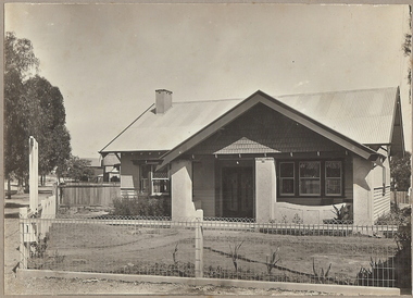
In 1931 electoral rolls, Eric Robert Kevil (1901- 23/5/1980) and his wife lived at 129 Russell St. He had married Edna May Cornish in 1921. By 1943 they had both moved to 77 Valley Pde., Camberwell.Black and white photograph mounted on rectangular brown board. House, pale weatherboard with rough cast above. Corrugated iron roof, one chimney, shingles in gable over verandah, diamond leadlights, bow window L.H., recessed front door rough east surround and pillars to verandah, concave top to verandah wall. Paling side and rear woven wire front and near boundary, lintel over front gate, letterbox. Written on back of photoboard ' Mr. Kevill's Russell and Olinda St., built to order £850 sold, 15.6.34' Date Stamp on back '11 April 1930'Frank A. Jeffree, Bendigorussell street, e.r. kevil, russell street bendigo, t.c. watts and son -
 Ringwood and District Historical Society
Newspaper, Scrapbook Clipping, Library Collection, Ringwood, Victoria, `
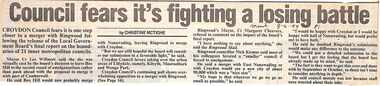
``Newspaper clipping from "The Mail" 8 -6- 94 P1 - Council fear's it's fighting a losing battle by Christine McTigheCroydon Council fears it is one step closer to a merger with Ringwood following the release of the Local Government Board's final report on the boundaries of 21 inner metropolitan councils. Croydon Mayor Cr Les Wilmott favors taking over the urban areas of Lilydale, namely Kilsyth, Mooroolbark and Wonga Park. The council fears that the Board has made up its mind to a merger between Croydon and Ringwood, which the councils don't want.` -
 Eltham District Historical Society Inc
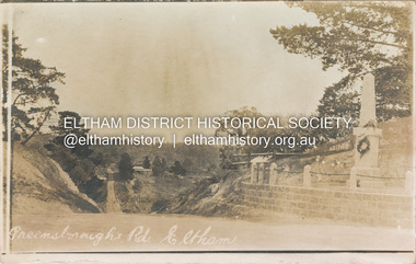
Postcard - Photograph postcard, Greensborough Road, Eltham, c.1925
Rare postcard showing view looking down Bridge Street with the Eltham Obelisk in situ in its original location. The Obelisk War Memorial was unveiled 3 August 1919. Subsequent to the unveiling provision was made of a stone retaining wall topped with a chain link and granite stone boundary. Along with the use of the name Obelisk Corner, the Bridge Street bridge was also known as Obelisk Bridge. The Obelisk was relocated to the fornt garden of the Eltham RSL sub-branch in the mid 1950s as a result of road widening and corner improvements. The Bridge Street Bridge was replaced with a new concrete bridge in 1956-1957.Digital file only Postcards scanned from the collection of Michael Aitken on loan to EDHS, 2 Sep. 2022michael aitken collection, eltham, postcards, bridge street, bridge street bridge, obelisk, obelisk corner, eltham cenotaph, eltham obelisk, war memorial, main road -
 Eltham District Historical Society Inc
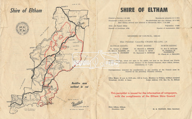
Pamphlet, Shire of Eltham, December 1962, 1962
Ratepayer information pamphlet issued by Eltham Shire Council. Gives details on shire boundaries and bushfire area, basic history, Councillors by Riding, meetings,office hours. Also information on the 1962 bushfires that raged throughout half the shire, 14-16 January 1962; local laws regarding dogs; Rates, Works Programme, Shire Offices and Town Planning The 1962 bushfire took two lives and caused damage to property approaching £1 million. Approximately 180 habitable dwellings were destroyed, hundreds of miles of fencing were burnt and thousands of acres of pasture lost.Colour bifold printed double sided (4 pages) councillors, dogs, eltham shire council, eltham shire office, infrastructure, rates, ridings, shire boundaries, shire of eltham, town planning, victorian bushfires - 1962, works programme -
 Eltham District Historical Society Inc
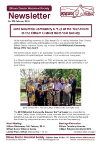
Newsletter, Newsletter, No. 238 February 2018
Contents: • 2018 Nillumbik Community Group of the Year Award to the Eltham District Historical Society • February Meeting • March Excursion – Eltham cemetery Artworks • Eltham 1950s – Childhood Reminiscences – Part 2 by Ann Constable • William Shillinglaw’s Homework Book by Richard Pinn • Early Eltham Shire Boundaries by Russell Yeoman • Wanted – a Treasurer • My Early Eltham Recollections – Part 1 by Alex Smith • Members On-line Survey – December 2017 • Neil Douglas by Wendy Wilson • News of Eltham England by Russell Yeoman • Webster Survey Group • ….and also • Contacts for the Eltham District Historical SocietyThe Shire of Eltham Historical Society was formed in October 1967. The first newsletter of the Society was issued May 1978 and has been published continuously ever since on a bi-monthly basis. With the cessation of the Shire of Eltham in late 1994, the Society's name was revised to Eltham District Historical Society and this name first appeared with issue No. 103, July 1995. The collection of the Society's newsletters provides a valuable resource on the history of the Society's activities, office bearers and committee members, guest speakers and subjects of historical interest pertinent to the former Shire of Eltham and the Eltham District.A4 newsletter distributed to membersnewsletter, eltham district historical society, shire of eltham historical society -
 Ballarat Tramway Museum
Map, Electric Supply Co. of Vic (ESCo), Ballarat Electoral Map - ESCo, 1900
Document prepared by the Electric Supply Co of Victoria, as part of an order under the Electric Light and Power Act 1896, section 5 of order No. 17 granted to company. Dated 19/2/1901 and signed by the Postmaster-General. Shows the order area being parts of the City of Ballaarat, Sebastopol and Ballarat East. Shows the street names, boundaries, principal power line routes, land reserves, parks, mine locations, railways and Lake Wendouree. Signed by R L Williams Town Clerk City of Ballarat, J R Hall for the Borough of Sebastopol, and John Gent for the Town of Ballarat EastYields information about the power supply to the Ballarat area.Cloth backed paper map, coloured and marked up as exhibit 17.Notes in ink including the signature of Benjamin Deakin 24/9/00 and certified by the three involved municipal Town Clerks.ballarat power supply, esco, electric supply co of victoria, city of ballaarat, east ballarat, sebastopol, orders, power lines, power supply -
 Surrey Hills Historical Society Collection
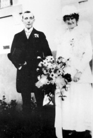
Photograph, Wedding Day of Amelia Amy Jacobs and James Dodgshun from Surrey Hills, 1916
Amelia Allan (Amy) Jacobs on her marriage to James Dodgshun in 1916; photographed at the home of her grandfather, "Terreglea" in Boundary (Warrigal) Road, Surrey Hills. Amelia attended Ormiston Girls' School in Mont Albert soon after its opening in 1900. Her mother was Eleanor Mills, youngest daughter of Robert Shortbridge Mills and Ann Lovelady. She died soon after the birth of Amy. Her father was Henry Atwood Jacobs. Following Eleanor's death Henry married Amy Lilian Scales. The donor Winifred Yarnold (nee Jacobs) was their youngest daughter and Amy's half-sister.Lady dressed as bride wearing a white dress and possibly a lace jacket with a fluffy collar and matching hat, carrying a large bouquet of flowers. The man is wearing a dark suit and carrying a top hat.wedding dresses, house names, surrey hills, warrigal road, clothing and dress, hats, terreglea, the tower house, weddings, wedding parties, ormiston girls school, schools, mont albert, miss amelia allan jacobs, miss amy jacobs, mr james dodgshun -
 City of Moorabbin Historical Society (Operating the Box Cottage Museum)
Clothing - Clothing, City of Moorabbin Tie, Circa 1960s
The City of Moorabbin existed from 1934 until 1994. Henry Dendy's Special Survey in 1841 of 5,120 acres in the Parish of Moorabbin , extended from Port Phillip Bay , then East to Boundary Road, South to South Road and North to North Road and became known as Brighton. 1859 Brighton became a Borough with its boundary Thomas Street ,and Bluff Road. In 1862 The Moorabbin Roads Board was formed and the extended area now included Cheltenham, Hampton, Sandringham, Black Rock, Beaumaris, Mentone and Mordialloc .and Little Brighton became known as Bentleigh. In 1871 the area became known as The Shire of Moorabbin. Gradually the area was separated into The Borough of Sandringham 1917, ( Black Rock, Beaumaris , Sandringham and Hampton ) Borough of Mentone and Mordialloc 1920, ( Parkdale ). In 1934 The City of Moorabbin was established for the area from South East corner of Thomas Street and North Road , East to Warrigal Road, Clayton Road, Kingston Road , Lower Dandenong Road, then South along Nepean Highway to Balcombe Road and along Bluff Road, Cummins Road, Nepean Highway, Thomas Street to North Road In the 1994 Amalgamation of Councils the City of Moorabbin was divided between the new City of Kingston in the South ( from South Road) and the new City of Glen Eira to the North . It was the largest Municipality in Victoria with a population of 118,865 in 1974This tie c 1960 is a memento of the City of Moorabbin 1934 - 1994Maroon colour, polyester, man's tie with the crest of City of Moorabbin woven on front.around circle enclosing Coat of Arms ; CITY OF MOORABBIN city of moorabbin, moorabbin roads board, moorabbin, brighton, dendy's special survey 1841, early settlers, pioneers, market gardners, dendy henry, were jonathan b, cheltenham, bentleigh, mentone, sandringham, mair william, bent thomas -
 Clunes Museum
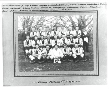
Photograph, HORNBY STUDIO - BALLARAT, FOOTBALL CLUB 1930, 1930
PHOTOGRAPH KEPT AT CLUNES FOOTBALL CLUBPHOTOGRAPH OF CLUNES FOOTBALL CLUB 1930 - MOUNTED ON GREY CARD WITH DARK GREY BORDER .1 ORIGINAL PHOTOGRAPH MOUNTED .2 MOUNTED PHOTOGRAPH WITH NAMES AND 'CLUNES FOOTBALL CLUB 1930' .3 PHOTOCOPY OF .2.2 LIST OF NAMES : BACK: BRIT JONES, (PRES).L EXELBY, L THOMAS,M ROGERS, M MITCHELL, R MCKENZIE, N SPARK, A CLARKE, MINTY ROBERTS, (TRAINER), CENTRE: M O'DONNELL, R DUNN, R ADAM, L CARTER (V.C)., D WRIGHT( CAPT), G LEISHMAN, G DUNN, J LEISHMAN. FRONT: S DUNN, H PETTIT, J PASCOE(BOUNDARY), E BROWN, G RICKARD.photographs, football, football club 1930 -
 Bendigo Historical Society Inc.
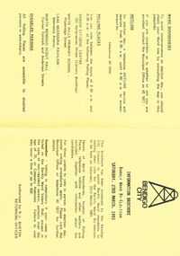
Document - BENDIGO CITY INFORMATION BROCURE BARKLY WARD, 23 March 1991
Bendigo City Information Brochure Barkly Ward By-Election. Saturday, 23rd March, 1991. Brochure by the Bendigo City Council to assist Barkly Ward residents in casting their vote in Barkly Ward, 23 March, 1991. Authorised by R J Burton, Returning Officer. Map of Barkly Ward. Candidate Information, Lois Angus, David Anderson, Lynne Geri. Ward Boundaries. Hotline. Polling places: Senior Citizens Centre (Bendigo), White Hills Primary School, Lake Weeroona Pavilion, North Bendigo Scout Hall. Disabled Persons all Polling Places are accessible to disabled persons in wheelchairs.government, local, barkly ward, bendigo city information brochure barkly ward by-election. saturday, 23rd march, 1991. 23 march, 1991. authorised by r j burton, returning officer. map of barkly ward. candidate information, lois angus, david anderson, lynne geri. ward boundaries. hotline. polling places: senior citizens centre (bendigo), white hills primary school, lake weeroona pavilion, north bendigo scout hall. all polling. accessible to disabled -
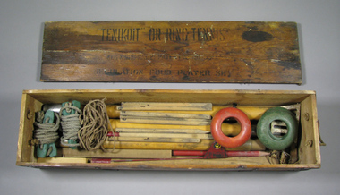 Tennis Australia
Ring tennis set, Circa 1922
A Ring Tennis set chest (.1) containing: rings (.2 - .5); guy ropes (.6 - .7); net posts (.8, 2 parts, .9, one part); court boundary markers (.10 - .19); rope (.20), and a metallic flag marker (.21). Eight miscellaneous pieces also feature. Inscription across top of lid: "TENIKOIT' OR RING TENNIS/...REGULATION FOUR PLAYER SET. Across top of base: R.H. MOTTRAM/(SOLE MAKER)/CHURCH STRETTON/SHROPSHIRE. On sides of box: TENIKOIT/NO. 2A. Materials: Wood, Metal, Lacquer, Ink, Glue, Rubber, Paint, Rope, Cord, Stringtennis -
 Bendigo Historical Society Inc.
Photograph - CENTRAL RED WHITE AND BLUE MINE, c1900s early
Black and White photo. On the right is the Central Red White and Blue Mine at the corner of Lilac and Honeysuckle Sts, at the front of the photo is Fadies Whim in Nettle Street, Iron Bark. Landscape view in background most likely High Street Bendigo/Golden Square boundary. Markings/Inscriptions: Central Red White and Blue Mine, Corner Lilac and Honeysuckle Sts. Fadies Whim, Nettle Street, Photo Taken early 1900s. Central Red White & Blue Whim. On rear of photo: Evolution in mining apparatus is illustrated in this photograph - Bendigo. 2 Royal Historical Society of Victoria, Bendigo Branch stamps on rear also.central red white and blue mine, mining, lilac, honeysuckle, fadies whim, 1900s, poppet head -
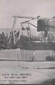
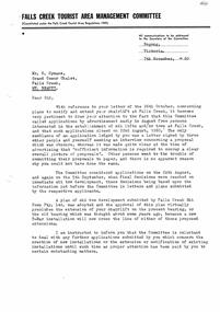 Falls Creek Historical Society
Document - Plans To Modify & Extend Chair Lift
Bob Hymans Collection Bob (Herman) Hymans (a former member of the Royal Netherlands Navy) was born in Bloemendaal, Holland on 30th September 1922. During World War II he fought against the Japanese in the Dutch East Indies (now Indonesia) and was imprisoned in Changi and on the Burma Railway. After gaining qualifications as a Ski Instructor, Bob arrived in Falls Creek in July 1950. Working as an Instructor and Supervisor at Bogong Lodge, Bob decided his future was in accommodation. He was successful in negotiating an indenture for land from the State Electricity Commission (SEC). It took Bob two years to build his Grand Coeur Chalet but, tragically, it was burned down in August 1961. Bob also built the first Chairlift in Australia. This was a single chairlift and the structure was built from wooden electricity poles. He was constantly full of new ideas and proposals for the village. Bob Hymans died on 7th July 2007. This Collection of documents and letters tells the story of Bob's endeavours to develop Falls Creek into the ski village it is today.This letter is significant because it reflects the relationship between Bob Hymans and the Management Committee.A letter from the Management Committee Falls Creek in relation to his application to modify his chairlift. It states that other people went to the effort of committing proposals to paper and that Bob Hymans should have done the same. The plan submitted by Falls Creek Ski Tows Pty. Ltd. had been accepted. This precluded any of Bob's proposals. It also states that the Committee was reluctant to deal with any further applications from Mr Hymans until he dealt with other outstanding matters. These included lodging a complete proposal for his restaurant and also storage of equipment within the boundaries of his licensed area.falls creek tourist area management committee, chairlift proposals, planning, bob hymans -
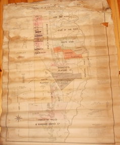 Bendigo Historical Society Inc.
Map - MARKS COLLECTION: MAP MINES BALLARAT AREA 1887
Large buff coloured map, wooden strip on bottom, top hanger missing, showing mine boundaries in Ballarat mining area. Mines include from top of map Bonshaw No. 1; Band and Albion Consolidated Company; Central Bonshaw; North Bonshaw; Star of the East block Claim; Star of the East; South Star; Owen's Freehold; Central Plateau; Sebastopol Plateau Company; Sebastopol Star; Sebastopol Plateau No. 1; South Plateau; Prince of Wales; Bonshaw United company; Gay's Freehold. Map prepared by Robert Alan, under the direction C.W. Langtree, Secretary for Mines, and Chief Mining Surveyor.map, ballarat, ballarat, mining, goldmining -
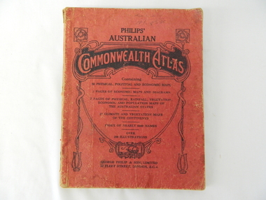 Kiewa Valley Historical Society
Atlas Australian Commonwealth, Philips' Australian Commonwealth Atlas, 1944
This atlas, printed in 1944, details not only the geographic and political boundaries of the world as it was at that time but also the snap shot of life of the time. This snap shot in time covers the major Australian cities, the major farming, grazing, industrial and sporting/recreational activities. Also there are snap shots of similar activities from other global areas. The period also covered World War II, detailed by a photo of "shell making", munitions, required by Australian soldiers. The great political and territorial changes made as a result of World War II can be clearly identified for example , Israel (the Jewish homeland). The various prewar colonies of major European nations.This atlas was used by children of a Kiewa Valley family and shows the value and the general educational exposure that these children had at this time. The rural setting and within the backdrop of a world war did not severely alter the life style of children in this region. The "news reels" shown in cinemas of cities and larger towns were the only visual realisations of major events of global significance available to these children. The information provided by this atlas allowed students to glimpse at what the "outside world" was. The majority of these students would possibly never see these regions for themselves. The great communication facilities of the late 1900s and beyond, was still only science fiction.This atlas has a thick (350 g/m) red cardboard cover with bold black lettering and shading. The cover is set out within a shield like frame. The shield is held up by two square markings, each with a four part circular pattern and a cord entwining two pendulum structures ending with a bowl figure at the bottom. There is a semi circular form enclosing a printed book contents list. The inside cover has the atlas title and contents and the publisher details. The atlas contain 56 pages of world and Australian maps, vegetation and rainfall maps. Within this atlas there are 27 double sided pages of black and white photographs depicting life styles, buildings, landscapes and prominent and significant to Australia males from 1652 to 1944. The pages are of approximately 200 g/m and have the yellow aged appearance.On front cover "Philips' Australian COMMONWEALTH ATLAS" and underneath "Containing" underneath "60 PHYSICAL, POLITICAL AND ECONOMIC MAPS". Publisher George Philip & Son, Limited 32 Fleet Street, London E.C. 4. Inside cover are: written, in freehand and in ink the following names and dates; "J.Muller Form V 1945", "L L Muller Form IV 1946", "N.J. Muller Form I + II + III 1948 +49 + 50" and "D Muller Form I 1949". also handwritten and in pencil is "Peter Leslie". On the last page is a small freehand sketch of Australia in biro.1940s school curriculum, rural education, 1940s atlas, australian atlas -
 Victorian Interpretive Projects Inc.
Photograph - Colour, Clare Gervasoni, Sculpture of Portuguese explores at Warrnambool, 02/09/2012
The sculptural installation was a gift from the Portuguese government and presented to Warrnambool City Council. The sculptor, Jose Nuncio, completed the work in 1999, and it was inaugurated at Warrnambool in 2001. Prince Henry the Navigator founded a school of navigation in Sagres, Portugal. This led to navigation techniques that made the 15th century voyages of discovery possible. The vision of Prince Henry brought together ship builders, cartographers, instrument makers and mathematicians. Vasco de Gama rounded the southern tip of Africa and sailed across the Indian Ocean to India in 1496. This started a new era of trade and exploration, expanding the boundaries of the known world, and linking the east with west.Six colour photographs of a sculptural installation at Warrnambool. Busts of Vasco De Gama and Prince Henry the Navigator feature in the installation. Images also include two informative plaques containing information on De Gama and the Prince.warrnambool, exploration, navigator, de gama, prince henry the navigator, portugal, portuguese, david atkinson, john pandazopoulos -
 Bendigo Historical Society Inc.
Document - Golden City Implements Foundry, Ironbark, Bendigo, 1960-1980s
This foundry had been a landmark in Mt Korong Road for many years. It began with an Osborne and Mitchell. After 1914 when mining declined, it became the Golden City Implement boundary and the name can still be seen painted on on the façade which faces the intersection of Marong Road (Calder highway) and Eaglehawk Road. The interior is a mass of used and un-used machinery scattered amongst modern lathes and more modern apparatus. The yard was a fascinating graveyard of past times, with old mining and agricultural scrap everywhere mixed up with coke and slag from the smelting sheds at the rear. A feature of the foundry was the manufacturer of cast iron lace. National Trust Survey Data Sheet and article from the Bendigo Advertiser November 4th 1981. Osbornes Ironbark Foundryhistory, national trust bendigo collection, bendigo, foundary, iron bark bendigo -
 Kew Historical Society Inc
Photograph - Willsmere [Kew] Billabong, 1993
Willsmere Park is bounded by the the Yarra River, Green Acres Golf Club, Willow Grove and the Eastern Freeway. The land on which the park is now situated was bought by Thomas Wills at the Crown Land Sales of 1846 (Section 56). From the 1840s to the 1940s it was intensively farmed. The park is dominated by very large playing fields, while planting to the southern boundary was undertaken when the Eastern Freeway was built. It is only along the banks of the Yarra that there is any remnant native vegetation. Willsmere Park is of significance as an area of open land that remains from the flood plain that once dominated northern Kew. (Source: Kew Conservation Study, 1988)Original colour small format polaroid photograph of the 'Kew Billabong' in the Willsmere Park, taken on 16 September 1993."Willsmere Billabong 16.9.93"kew billabong, willsmere park, yarra river -- billabongs -
 Kew Historical Society Inc
Photograph - Yarra River in flood at the Willsmere Park, 1993
Willsmere Park is bounded by the the Yarra River, Green Acres Golf Club, Willow Grove and the Eastern Freeway. The land on which the park is now situated was bought by Thomas Wills at the Crown Land Sales of 1846 (Section 56). From the 1840s to the 1940s it was intensively farmed. The park is dominated by very large playing fields, while planting to the southern boundary was undertaken when the Eastern Freeway was built. It is only along the banks of the Yarra that there is any remnant native vegetation. Willsmere Park is of significance as an area of open land that remains from the flood plain that once dominated northern Kew. (Source: Kew Conservation Study, 1988)Original colour small format polaroid photograph of the Yarra River in flood at the Willsmere Park, taken on 16 September 1993."Yarra River at Willsmere Park Flooding 16.9.93"willsmere park, yarra river -- floods -- kew (vic.) -
 Kew Historical Society Inc
Photograph - Flooding in the Willsmere Park, 1993
Willsmere Park is bounded by the the Yarra River, Green Acres Golf Club, Willow Grove and the Eastern Freeway. The land on which the park is now situated was bought by Thomas Wills at the Crown Land Sales of 1846 (Section 56). From the 1840s to the 1940s it was intensively farmed. The park is dominated by very large playing fields, while planting to the southern boundary was undertaken when the Eastern Freeway was built. It is only along the banks of the Yarra that there is any remnant native vegetation. Willsmere Park is of significance as an area of open land that remains from the flood plain that once dominated northern Kew. (Source: Kew Conservation Study, 1988)Original colour small format polaroid photograph of flooding in the Willsmere Park, taken on 16 September 1993."Flooding of shared path from Willsmere Billabong 16.9.93"willsmere park, yarra river -- floods -- kew (vic.), kew billabong -
 Kew Historical Society Inc
Photograph - Flooding in the Willsmere Park, 1993
Willsmere Park is bounded by the the Yarra River, Green Acres Golf Club, Willow Grove and the Eastern Freeway. The land on which the park is now situated was bought by Thomas Wills at the Crown Land Sales of 1846 (Section 56). From the 1840s to the 1940s it was intensively farmed. The park is dominated by very large playing fields, while planting to the southern boundary was undertaken when the Eastern Freeway was built. It is only along the banks of the Yarra that there is any remnant native vegetation. Willsmere Park is of significance as an area of open land that remains from the flood plain that once dominated northern Kew. (Source: Kew Conservation Study, 1988)Original colour small format polaroid photograph of flooding in the Willsmere Park, taken on 16 September 1993."Flooding of Willsmere Park from Yarra 16.9.93"willsmere park, yarra river -- floods -- kew (vic.) -
 Kew Historical Society Inc
Photograph - Flooding of Willsmere Park from Yarra, 1993
Willsmere Park is bounded by the the Yarra River, Green Acres Golf Club, Willow Grove and the Eastern Freeway. The land on which the park is now situated was bought by Thomas Wills at the Crown Land Sales of 1846 (Section 56). From the 1840s to the 1940s it was intensively farmed. The park is dominated by very large playing fields, while planting to the southern boundary was undertaken when the Eastern Freeway was built. It is only along the banks of the Yarra that there is any remnant native vegetation. Willsmere Park is of significance as an area of open land that remains from the flood plain that once dominated northern Kew. (Source: Kew Conservation Study, 1988)Original colour small format polaroid photograph of flooding in Willsmere Park resulting from heavy rain on 15 September 1993."Flooding of Willsmere Park from Yarra 16.9.93"yarra river -- floods -- kew (vic.), willsmere park -
 Kew Historical Society Inc
Photograph - Willsmere [Kew] Billabong, 1993
Willsmere Park is bounded by the the Yarra River, Green Acres Golf Club, Willow Grove and the Eastern Freeway. The land on which the park is now situated was bought by Thomas Wills at the Crown Land Sales of 1846 (Section 56). From the 1840s to the 1940s it was intensively farmed. The park is dominated by very large playing fields, while planting to the southern boundary was undertaken when the Eastern Freeway was built. It is only along the banks of the Yarra that there is any remnant native vegetation. Willsmere Park is of significance as an area of open land that remains from the flood plain that once dominated northern Kew. (Source: Kew Conservation Study, 1988)Original colour small format polaroid photograph of Willsmere [Kew] Billabong on September 1993."Willsmere Billabong 16.9.93"yarra river -- floods -- kew (vic.), willsmere park -
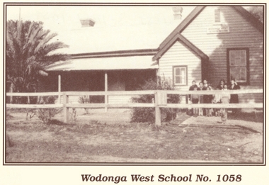 Wodonga & District Historical Society Inc
Photograph - Wodonga West School No. 1058
Wodonga West School opened on 24 January 1870 and closed on 9 May 1950. It was located near the current intersection of McKoy Street and the Hume Freeway in West Wodonga on land donated by J.W. Klinge. The school replaced an older school, “Green Hills School, which was located north of the railway line. A public telephone was installed at the school and the mail service operated from the school three days each week. In 1935 a row of 15 ornamental trees was planted along the boundary fence, one for each of the pupils at the school. When this school closed the nine remaining students were transferred to Wodonga Primary School.This image is significant because it documents the early developments in the provision of education in Wodonga, Victoria A black and white photo of a group of children standing outside the Wodonga West School building.wodonga schools, wodonga west primary school, education wodonga -
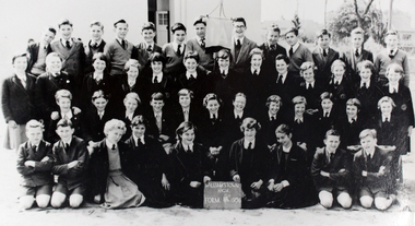 Williamstown High School
1956 Class 1A
Copy of a black and white photograph of Form 1A, 1956. Accompanied by a caption.Caption reads: Form 1A 1956. The photo was taken near Pasco Street boundary. Navy blue tunic, blazer and beret was the winter uniform for girls. In Summer they had a green dress trimmed with white and a straw hat. The boys uniform was grey and were expected to wear black caps with red buttons on the top (lots were kept in pockets). Original photo on loan from Iris Whitehurst (Webb). On back of photograph: Form 1A 1956 "Dingoes". Iris Webb has original.williamstown high school, 1956, class photos -
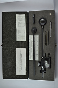 Melbourne Water
Compensating Polar Planimeter, c.1970s
As the Yarra became unsuitable as a source of water, several attempts were made to find alternative sources for the growing population of Melbourne. It was not until 1891 that the efforts to sewer Melbourne came to fruition with the setting up of the Melbourne Metropolitan Board of Works (MMBW), now known as Melbourne Water. From 1891 until 1992, it was the responsibility of the MMBW to safeguard public health by providing a sewerage system and a safe water supply system. In 1992, The MMBW merged with a number of smaller urban water authorities to form Melbourne Water. This item was used by MMBW employees as a measuring device to determine areas or figures on a plane surface having either straight or irregular boundaries. The Compensating Polar Planimeter is of historical significance for its association with the former Melbourne and Metropolitan Board of Works (MMBW). This measuring device is perfectly intact and a rare surviving object of standard Board issued equipment. The kit is significant for its representativeness of the theme of Technology in building Victoria's industries and workforce, which continues to resonate strongly within Melbourne Water today.The instrument is inside a black metal case with accessories including: Setting bar, screwdriver, Allen key and spare pole point. Inside is also the adjustable planimeter. mmbw, melbourne water, melbourne metropolitan board of works, technology, instrument, work, measure, historic, water, staff -
 Wodonga & District Historical Society Inc
Album - Ringer's River by Des Martin - Plate 12 - A positive result from the customs duty
Meantime back at Camoola "Top Or Nothing" Price, known to stockmen as "Old Stop At Nothing", and his shifty ex-jockey clerk Billy Matthews, have been stunned by the Victorian customs duty of 30 shillings per head on cattle, and 50 shillings per head on horses, suddenly promulgated just prior to a very important sale. Caught with a lot of cattle he cannot unload, and a property sale that has gone astray, Price accepts offers for both from O'Day, who thus sets himself up cheaply with a good holding that runs down Barmagulla's back boundary to the Murray River at the point where he often swims across.The album and images are significant because they document literature written by a prominent member of the Wodonga community. The presentation of this precis was supported by several significant district families and individuals.Ringer's River Album Coloured photo Plate 12des martin, many a mile, ringer's river, northeast victoria stories -
 Merri-bek City Council
Work on paper - Aerosol painting, synthetic polymer, gouache and colour pencils on Magnani paper, Luke King, Portrait, 2023
Luke King’s mixed media artwork Portrait (2023) was shown in the group exhibition Fever’Dreams at the Counihan Gallery in 2023. The group exhibition explored the slippery boundaries between abstract and figurative artwork, showcasing local artists with a strong connection to Merri-bek’s arts community. King uses portraiture to highlight the importance of gesture and facial expression in personal storytelling. Exhibition curator of Fever’Dreams, Mitchel Brannan, writes of King’s work: ‘King explores the profound capacity of the human face to convey emotions within the context of constraint. Through his art, King invites viewers to reflect on the complexities of human expression and the underlying dynamics of restraint within society.’ -
 Bendigo Historical Society Inc.
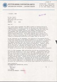
Letter - KANGAROO FLAT GOLD MINE COLLECTION: LETTER WESTERN MINING TO D. CAHILL
Letter from Western Mining Corporation to D.W. Cahill, Barrister, Bendigo dated 1st October, 1980, from J.H. Lalor, Exploration Manager, Minerals, WMC, regarding the objective of the Western Mining Corporation exploration program on the Bendigo goldfield. The major objective is to develop a long term mining operation 'which would be environmentally acceptable' It was considered that the value 'of such an operation to the local community and the Bendigo region would be substantial'. Bendigo Mining NL was planning 'to undertake a commercial mining operation using some existing facilities at the Central Deborah Gold Mine' Exploration activity was prohibited within the boundaries of the municipality of Bendigo prior to September 10th. 1980.bendigo, western mining corporation, exploration, central deborah gold mine. -
Port Melbourne Historical & Preservation Society
Photograph - J Kitchen & Sons site, Port Melbourne, 1978
Large black and white aerial photo in narrow gold-coloured metal frame of J Kitchen & Sons Pty Ltd factory . Port Melbourne Football/Cricket ground top left of photo . Photo taken approx 1978 or later, dated due to types of cars and by comparison with buildings along Boundary St opposite as shown in photos of catalogue iten 3202. Dated also by Glen Cosham who was a Councillor when Woodruff St was sealed and this did not occur until after Oct 1977, probably early 1978. It was paid for by the Country Roads Board as part of the preparations for the opening of the West Gate Bridge and the Johnson St Bridge later that year.industry - manufacturing, built environment - industrial, j kitchen & sons pty ltd, pental products pty ltd, symex, north port oval