Showing 619 items matching "shire offices"
-
 Glen Eira City Council History and Heritage Collection
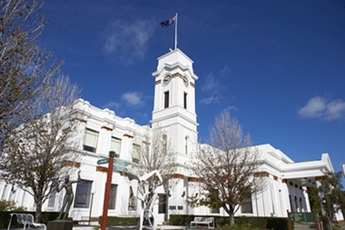
Photograph - Building, Glen Eira Town Hall, 1884
Originally known as Caulfield Shire Hall, the original 1884 building was designed by Shire surveyor Sydney Smith. In 1931 the Caulfield Town Hall, as it was then known, was remodelled to include the main hall and foyer and a Neo-Grecian portico with Corinthian Order columns. Major works completed since 1945 include Caulfield Arts Complex (opened 20 August 1988), Caulfield Library (opened 4 December 1993) and the award-winning Caulfield Municipal Offices extension which opened on 24 February 1991. The building is listed as No. H0106 in the GECC Heritage Overlay Schedule. The site also includes a Significant Tree (H&H Register No. 034). Brick exterior of two storey building painted white and featuring pillared portico entrance and solid glass doors on Glen Eira road facing north. On the eastern side of the portico is a two storey clock tower with clock surmounted by a flagpole and flag. Some of the eastern section of the building is original with various alterations over the years. The award winning service centre and offices in the westerly aspect of the town hall were extended on to the original buliding in 2000.building, town hall, council, local government, caulfield, glen eira, moorabbin, sydney smith -
 Sunbury Family History and Heritage Society Inc.
Photograph, c 1920s
The 'Meeise' French car is parked outside the former Mechanics Institute Hall in Stawell Street, Sunbury. J Eadie was responsible for the building of the hall in 1885 and the foundation stone was laid by Lady Janet Clarke. The former Shire of Bulla conducted their council meetings in the hall from 1923 until 1956 when new offices were built in Macedon Street. Later the RSL took over occupancy of the hall and it became known as the Memorial Hall. In the early 1970s Stawell Street was cut off to traffic and incorporated into the Village Green.Over the years the Memorial Hall has been the venue for many community events from debutant balls, flower shows, local gatherings, celebrations and markets to name a few.A sepia photograph with a cream border of a tree lined street with a building in the foreground and a vintage car parked outside the building. Tall pine trees are growing behind the fenceline.mechanics institute, shire of bulla -
 Port Fairy Historical Society Museum and Archives
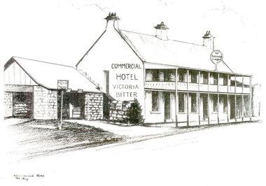
Postcard - Pencil Drawing
John J. Huntly appears to have been the only licensee of the Royal Oak Hotel, built in 1858. He was a Councillor of the Municipality of Belfast at the time and later became the Secretary of the newly formed Minhamite Shire in 1872. By 1861 D. Smith appears as the licensee of the now named Commercial Hotel. In 1877 it was offered for sale—the building described as follows “Built of bluestone with slate roof, having a frontage to Bank street of 106 feet, 6 inches. Accommodation consists of twelve bedrooms, eight sitting rooms, bathroom, bar and cellar and detached kitchen also of bluestones, with outside offices. Around this time beside its usual business the hotel had various rooms for visiting doctors and a dentist. Dr. Berncastle, who was associated with the Sydney Eye Infirmary, performed several operations there on those suffering from cataracts. It was the meeting place for the Port Fairy Freemasons, before their Lodge was built in James street, and all the local sporting clubs, at one time or another. The veranda was added in 1900. The name Royal Oak was restored this century, but the name Commercial Hotel can still be seen in the leadlight window over the front entrance. The hotel still continues serving patrons with beverages and meals but no beds these days. There is also an addition to the building, as seen in the bottom illustration— a bottle shopBlack and white sketch photographed Line drawing of the Commercial hotelhotel, building, commercial, oak and anchor, inn, pub, d.smith -
 Port Fairy Historical Society Museum and Archives
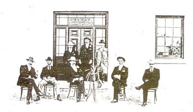
Photograph
John J. Huntly appears to have been the only licensee of the Royal Oak Hotel, built in 1858. He was a Councillor of the Municipality of Belfast at the time and later became the Secretary of the newly formed Minhamite Shire in 1872. By 1861 D. Smith appears as the licensee of the now named Commercial Hotel. In 1877 it was offered for sale—the building described as follows “Built of bluestone with slate roof, having a frontage to Bank street of 106 feet, 6 inches. Accommodation consists of twelve bedrooms, eight sitting rooms, bathroom, bar and cellar and detached kitchen also of bluestones, with outside offices. Around this time beside its usual business the hotel had various rooms for visiting doctors and a dentist. Dr. Berncastle, who was associated with the Sydney Eye Infirmary, performed several operations there on those suffering from cataracts. It was the meeting place for the Port Fairy Freemasons, before their Lodge was built in James street, and all the local sporting clubs, at one time or another. The veranda was added in 1900. The name Royal Oak was restored this century, but the name Commercial Hotel can still be seen in the leadlight window over the front entrance. The hotel still continues serving patrons with beverages and meals but no beds these days. There is also an addition to the building, as seen in the bottom illustration— a bottle shopBlack and white photograph of 8 males formally posed outside entrance to Commercial hotelhotel, building, kemp family, bank street, royal oak, commercial, oak and anchor, d.smith -
 Port Fairy Historical Society Museum and Archives
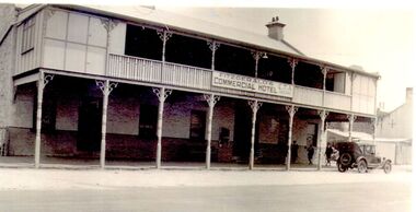
Photograph
John J. Huntly appears to have been the only licensee of the Royal Oak Hotel, built in 1858. He was a Councillor of the Municipality of Belfast at the time and later became the Secretary of the newly formed Minhamite Shire in 1872. By 1861 D. Smith appears as the licensee of the now named Commercial Hotel. In 1877 it was offered for sale—the building described as “Built of bluestone with slate roof, having a frontage to Bank street of 106 feet, 6 inches. Accommodation consists of twelve bedrooms, eight sitting rooms, bathroom, bar and cellar and detached kitchen also of bluestones, with outside offices. Around this time beside its usual business the hotel had various rooms for visiting doctors and a dentist. Dr. Berncastle, who was associated with the Sydney Eye Infirmary, performed several operations there on those suffering from cataracts. It was the meeting place for the Port Fairy Freemasons, before their Lodge was built in James street, and all the local sporting clubs, at one time or another. The sign on the hotel states "Fitzgerald's Commercial Hotel" more research is being undertaken as to this owner or lessee. The veranda was added in 1900. The name Royal Oak was restored this century, but the name Commercial Hotel can still be seen in the leadlight window over the front entrance. The hotel has now been transformed into apartments and a restaurant called the Oak and Anchor Image of the hotel at an earlier timeBlack and white photograph of Two story bluestone painted commercial hotel with large verandah car at kerbhotel, building, bank street, john j huntly, d smith, royal oak, commercial, fitzgerald, kemp, oak and anchor -
 Vision Australia
Photograph - Image, AFB Mildura plaques, 1996
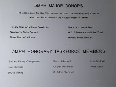
Radio was a key way of communicating with the blind and low vision community across Victoria, ensuring that news and information could be shared quickly and publicly. Some centres raised funds to develop their own studios, with local content programs, based in AFB offices. Mildura began 3MPH in 1998 as the result of major fundraising for equipment and support from AFB. Additionally a low vision clinic was also officially opened in that same year.3 plastic plaques with black writing on silver background3MPH Major Donors The Association for the Blind wishes to thank the following major donors who contributed towards the establishment of 3MPH Rotary Club of Mildura Deakin Inc Wentworth Shire Council Lions Club of Mildura The H & L Hecht Trust W C F Thomas Charitable Trust Mildara Blass Limited 3MPH Honorary Taskforce Members Shirley Penny, Chairperson, Kevin Ashelford, Lois Beckwith, Rob Duffield, Cr Don McKinnon, Ross Lake, Bruce Penny, Cr Eddie Warhurst This plaque commemorates the official opening of the Mildura Low Vision Clinic by the Chief Executive Officer of the Association for the Blind Mr John Cook, 5th August 1998. This plaque commemorates the official opening of Radio 3MPH 107.5FM by the Mayor of the Mildura Rural City Council, Cr Eddie Warhurst, 12th March 1998.association for the blind, 3mph, mildura -
 City of Greater Bendigo - Civic Collection
Work on paper - Photograph, W H Robinson, Druids Sandhurst Lodge No. 247, 01 / 11/ 1910
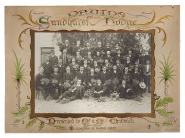
Druids are known to exist from around the 3rd century B.C. Their name may have come from a Celtic word meaning “knower of the oak tree.” Many of their ceremonies were carried out in oak groves, which they considered sacred and members were, at that time a mix of priest, judge, doctor and philosopher. The Druids enjoyed a revival in the 19th century and were taken up enthusiastically during the Victorian era. Druidry was believed to have been introduced into Australia in 1851 with the setting up of the first lodge in Melbourne under the name United Ancient Order of Druids. Unlike the Freemasons, the Druids were not a secret society and were not selective in who they let in, as long as they paid their dues and acted more like a benevolent society than a spiritual movement. "They originally operated when there were few benefits available from the government or employers and the introduction of sick leave and other employer provided benefits, combined with the gradual introduction of government subsidised medicine, caused the need for them to diminish." Druids House — in Swanston Street, was opened by the Lord Mayor in 1927 and was designed to be the movement's national head office. It was completed at a cost of 19,000 pounds. This photograph was believed to have been commissioned by the Druids of Bendigo to the Licensees of the Queens Head pub where they regularly met, situated on the corner of the Bendigo-Maryborough Rd & the Calder Alternate Hwy ( Lockwood Cross Roads). The old Marong Council offices were situated opposite from 1864 until around 1908 when new offices were then built in Marong. It is believed that this photograph and a photo of the pub were given to Marong Shire by descendants of the publicans, probably in the 90’s. Framed black and white group photographic portrait of 37 members of the Sandhurst Chapter of the Druids staged and shot outdoors. Each of the gentlemen is carrying a bouquet of flowers. The photograph has a gold inner mount with the second mount cut to give the impression of a frame. The outer mount is hand painted with botanical motifs and elaborate text c.t. DRUIDS Sandhurst Lodge/ No 247. l.c Presented to Mr and Mrs Chadwick / Lockwood / in recognition for kindness rendered.W. G. Robinson / Photo and J.H. Gribble / Long Gully / 1,11,10robinson photographer, j.h.b. gribble artist, chadwick, shire of marong, city of greater bendigo portraits, city of greater bendigo community groups -
 City of Greater Bendigo - Civic Collection
Photograph - Portrait of Councillor Keck, W H Robinson, c 1913
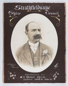
The district of Strathfieldsaye was proclaimed in 1861 and named a Shire on the 17th September in 1866. It remained a shire until amalgamation in 1994 when it became part of the City of Greater Bendigo. The shire was located 8 km to the south- east of Bendigo and covered an area of 601 square kilometres and extended from the Calder Highway to the Coliban and Campaspe Rivers. The shire's administration centre was in Strathfieldsaye until 1972 when new offices were opened in Kennington.Framed black and white head and shoulder portrait of Councillor Keck with hand coloured and drawn detail. Profile slightly to right with walrus moustache. Cut oval brown mount decorated with text and flowers. Hand written title top and lower centre.Strathfieldsaye / Shire Council / W.H. Robinson / Photo / Bendigo / J.H.E Gribbs / Presented by / Cr Herbert Keck / President 1903-4. 1912-13.shire of strathfieldsaye, councillor keck, strathfieldsaye shire council, president of strathfieldsaye shire -
 City of Greater Bendigo - Civic Collection
Photograph - Councillor group portrait, W H Robinson, Strathfieldsaye Shire Council, 1909
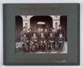
The district of Strathfieldsaye was proclaimed in 1861 and named a Shire on the 17th September in 1866. It remained a shire until amalgamation in 1994 when it became part of the City of Greater Bendigo. The shire was located 8 km to the south- east of Bendigo and covered an area of 601 square kilometres and extended from the Calder Highway to the Coliban and Campaspe Rivers. The shire's administration centre was in Strathfieldsaye until 1972 when new offices were opened in Kennington.Photographic group portrait of eleven Strathfieldsaye Shire Councillors in front of the Strathfieldsaye Shire Hall. Five men are seated and six standing with one man standing further in back ground on the building's verandah. Photograph is attached directly to green mount card and framed. Gold lettering on mount.Strathfieldsaye Shire Councillors / R. B. Brennan (Sec.) W. J. Lowdes S. Doak M. Burns () N Condon B. Code (Inspector) / WH Robinson Photo Bendigo / T Somerville / W. I. Long / Fred Osborne (President) H Keck / W Dresler / With the President's (Cr. Fred Osborne) Compliments / September 23rd, 1909shire of strathfieldsaye, strathfieldsaye shire council, president of strathfieldsaye shire, strathfieldsaye shire hall -
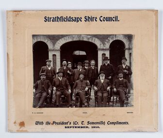 City of Greater Bendigo - Civic Collection
Photograph - Councillor group portrait, W H Robinson, Strathfieldsaye Shire Council
The district of Strathfieldsaye was proclaimed in 1861 and named a Shire on the 17th September in 1866. It remained a shire until amalgamation in 1994 when it became part of the City of Greater Bendigo. The shire was located 8 km to the south- east of Bendigo and covered an area of 601 square kilometres and extended from the Calder Highway to the Coliban and Campaspe Rivers. The shire's administration centre was in Strathfieldsaye until 1972 when new offices were opened in Kennington. Group portrait of 13 men / councilors, 5 seated and 8 standing dressed in suits. There are another 2 men further back in front of the hall doors. Photograph is taken outside the Strathfieldsaye Shire Hall.Srathfieldsaye Shire Council. / With the President's (Cr T. Somerville) Compliments. / September, 1910 / W.H. Robinson Photo. Bendigo Verso; William Drechslershire of strathfieldsaye, president of strathfieldsaye shire, strathfieldsaye shire council -
 City of Greater Bendigo - Civic Collection
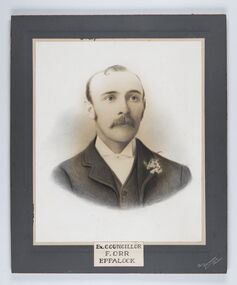
Photograph - Portrait of Councillor Orr, The Yeoman Studios, Ex. Councillor / F. Orr / Eppalock
The district of Strathfieldsaye was proclaimed in 1861 and named a Shire on the 17th September in 1866. It remained a shire until amalgamation in 1994 when it became part of the City of Greater Bendigo. The shire was located 8 km to the south- east of Bendigo and covered an area of 601 square kilometres and extended from the Calder Highway to the Coliban and Campaspe Rivers. The shire's administration centre was in Strathfieldsaye until 1972 when new offices were opened in Kennington. Eppalock Ward is one of three wards in the Greater Bendigo municipality which includes the former Strathfieldsaye Shire. Framed black and white head and shoulder portrait with hand coloured detail. Man with profile slightly to right, walrus moustache, image encircled. Photograph is attached to mount card. Hand written title lower centre.Ex. Councillor / F. Orr / Eppalock / The / Yeoman / Studiosshire of strathfieldsaye, councillor orr -
 City of Greater Bendigo - Civic Collection
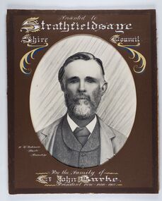
Photograph - Portrait of Councillor Burke
The district of Strathfieldsaye was proclaimed in 1861 and named a Shire on the 17th September in 1866. It remained a shire until amalgamation in 1994 when it became part of the City of Greater Bendigo. The shire was located 8 km to the south- east of Bendigo and covered an area of 601 square kilometres and extended from the Calder Highway to the Coliban and Campaspe Rivers. The shire's administration centre was in Strathfieldsaye until 1972 when new offices were opened in Kennington. Framed black and white head and shoulder portrait of Councillor Burke with hand coloured and drawn detail. Profile centre facing with beard. Cut oval brown mount decorated with text and fscrolls. Hand written title top and lower centre. Wooden frame with detail and gold inner.Presented to Strathfieldsaye / shire Council / w. H. robinson / Photo / Bendigo / By the family of / Cr John Burke / President 1890 - 1899 - 1900strathfieldsaye shire council, councillor burke, president of strathfieldsaye shire -
 City of Greater Bendigo - Civic Collection
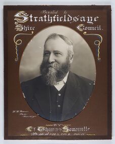
Photograph - Portrait of Councillor Thomas Somerville, W H Robinson
The district of Strathfieldsaye was proclaimed in 1861 and named a Shire on the 17th September in 1866. It remained a shire until amalgamation in 1994 when it became part of the City of Greater Bendigo. The shire was located 8 km to the south- east of Bendigo and covered an area of 601 square kilometres and extended from the Calder Highway to the Coliban and Campaspe Rivers. The shire's administration centre was in Strathfieldsaye until 1972 when new offices were opened in KenningtonFramed black and white head and shoulder portrait of Councillor Somerville with hand drawn detail. Profile slightly to left, face has full beard. Cut oval brown mount decorated with text and scrolls. Hand written title top and lower centre.Presented to / Strathfieldsaye / Shire Council / W. H. Robinson / Photo / Bendigo / by / Cr Thomas Somerville / President 1892 - 3. 1901.2. 1910.11 strathfieldsaye shire council, councillor somerville, president of strathfieldsaye shire -
 City of Greater Bendigo - Civic Collection
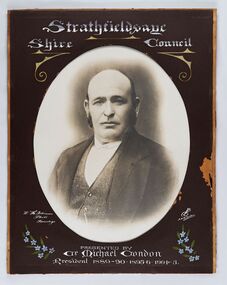
Photograph - Portrait of Councillor Michael Condon, W H Robinson
The district of Strathfieldsaye was proclaimed in 1861 and named a Shire on the 17th September in 1866. It remained a shire until amalgamation in 1994 when it became part of the City of Greater Bendigo. The shire was located 8 km to the south- east of Bendigo and covered an area of 601 square kilometres and extended from the Calder Highway to the Coliban and Campaspe Rivers. The shire's administration centre was in Strathfieldsaye until 1972 when new offices were opened in KenningtonFramed black and white head and shoulder portrait of Councillor Condon with hand coloured and drawn detail. Profile slightly to left. No facial hair. Cut oval brown mount decorated with text, scrolls and flowers. Hand written title top and lower centre.Strathfieldsaye / Shire / Council / W. H. Robinson / Photo / Bendigo / JMB Gribble / Presented by / Cr Michael Condon / President 1889 - 90. 1895-6. 1904 - 5strathfieldsaye shire council, president of strathfieldsaye shire, councillor condon -
 City of Greater Bendigo - Civic Collection
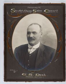
Photograph - Portrait of Councillor Doak, W H Robinson
The district of Strathfieldsaye was proclaimed in 1861 and named a Shire on the 17th September in 1866. It remained a shire until amalgamation in 1994 when it became part of the City of Greater Bendigo. The shire was located 8 km to the south- east of Bendigo and covered an area of 601 square kilometres and extended from the Calder Highway to the Coliban and Campaspe Rivers. The shire's administration centre was in Strathfieldsaye until 1972 when new offices were opened in Kennington.Framed black and white head and shoulder portrait of Councillor Doak with hand coloured and drawn detail. Left facing profile with walrus moustache. Cut oval brown mount decorated with text and scrolls. Hand written title top and lower centre.Presented to / Strathfieldsaye Shire Council / W. H. Robinson / Photo / JMB Gribble / by Cr S. Doak / President 1911 - 1912strathfieldsaye shire council, president of strathfieldsaye shire, councillor doak -
 City of Greater Bendigo - Civic Collection
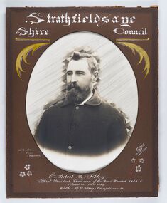
Photograph - Portrait of Councillor Sibley, W H Robinson
The district of Strathfieldsaye was proclaimed in 1861 and named a Shire on the 17th September in 1866. It remained a shire until amalgamation in 1994 when it became part of the City of Greater Bendigo. The shire was located 8 km to the south- east of Bendigo and covered an area of 601 square kilometres and extended from the Calder Highway to the Coliban and Campaspe Rivers. The shire's administration centre was in Strathfieldsaye until 1972 when new offices were opened in KenningtonFramed black and white head and shoulder portrait of Councillor Sibley with hand coloured and drawn detail. Profile slightly to left with walrus moustache and beard. Cut oval brown mount decorated with text, flowers and scrolls. Hand written title top and lower centre.Strathfieldsaye / Shire Council / W m Robinson / Photo / Bendigo / J N B Gribble / Cr Robert R Sibley / First President Chairman of the Road Board 1865 - 5 / President 1866 - 1869 / With Mrs Sibley's Complimentsstrathfieldsaye shire council, councillor sibley, president of strathfieldsaye shire -
 City of Greater Bendigo - Civic Collection
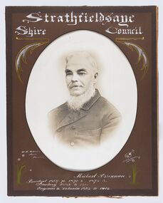
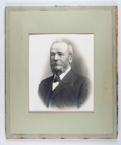
Photograph - Portrait of Councillor Brennan, W H Robinson
The district of Strathfieldsaye was proclaimed in 1861 and named a Shire on the 17th September in 1866. It remained a shire until amalgamation in 1994 when it became part of the City of Greater Bendigo. The shire was located 8 km to the south- east of Bendigo and covered an area of 601 square kilometres and extended from the Calder Highway to the Coliban and Campaspe Rivers. The shire's administration centre was in Strathfieldsaye until 1972 when new offices were opened in Kennington. Councillor Michael Brennan held roles of Shire Secretary and Clark of Works until around 1998 when his son R. B. Brennan was appointed Assistant Secretary and then Shire Secretary to assist his father with the work load during his later years. Michael Brennan remained Clerk of Works until his death at which time his son was appointed to the duties previously held by his father. Framed black and white head and shoulder portrait of Councillor Brennan with hand coloured and drawn detail. Profile to left. Cut oval brown mount decorated with text and flowers. Hand written title top and lower centreStrathfieldsaye / Shire Council / W H Robinson / Photo / Bendigo / J H B Gribble / Michael Brennan / President 1869 - 70. 1871 - 2. 1872 - 3 / Secretary 1882 to 1900 / Engineer & Valuator 1882 to 1902strathfieldsaye shire council, councillor brennan, president of strathfieldsaye shire -
 City of Greater Bendigo - Civic Collection
Photograph - Portrait of Councillor Long, Talma & Co
The district of Strathfieldsaye was proclaimed in 1861 and named a Shire on the 17th September in 1866. It remained a shire until amalgamation in 1994 when it became part of the City of Greater Bendigo. The shire was located 8 km to the south- east of Bendigo and covered an area of 601 square kilometres and extended from the Calder Highway to the Coliban and Campaspe Rivers. The shire's administration centre was in Strathfieldsaye until 1972 when new offices were opened in Kennington.Framed black and white head and shoulder portrait of Councillor Long. Profile to left with walrus moustache and mutton chops. Cut olive retangle mount. Verso; Long. On under board which has photograph attached; Talma & Co. / 119 Swanston St., / Melbournestrathfieldsaye shire council, councillor long -
 City of Greater Bendigo - Civic Collection
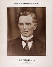
Photograph - Portrait of Shire Secretary Brennan, Unknown
The district of Strathfieldsaye was proclaimed in 1861 and named a Shire on the 17th September in 1866. It remained a shire until amalgamation in 1994 when it became part of the City of Greater Bendigo. The Shire was located 8 km to the south- east of Bendigo and covered an area of 601 square kilometres and extended from the Calder Highway to the Coliban and Campaspe Rivers. The shire's administration centre was in Strathfieldsaye until 1972 when new offices were opened in Kennington. Secretary Brennan, son of Councillor M. Brennan was appointed after his fathers death to the role and according to the The Bendigo Independent was in the role in 1917. See References.Framed black and white head and shoulder portrait of Councillor Brennan. Profile slightly to left. Cut rectangle cream mount. Hand written title top and lower centre. Shire of Strathfieldsaye / R. B. Brennan, Esq / Secretarystrathfieldsaye shire council, secretary strathfieldsaye shire -
 City of Greater Bendigo - Civic Collection
Photograph - Portrait of Councillor Hargraves, Bartlett Bros
The district of Strathfieldsaye was proclaimed in 1861 and named a Shire on the 17th September in 1866. It remained a shire until amalgamation in 1994 when it became part of the City of Greater Bendigo. The shire was located 8 km to the south- east of Bendigo and covered an area of 601 square kilometres and extended from the Calder Highway to the Coliban and Campaspe Rivers. The shire's administration centre was in Strathfieldsaye until 1972 when new offices were opened in KenningtonFramed black and white head and shoulder portrait of Councillor Hargraves. Profile slightly to right with walrus moustache. Cut rectangle brown mount decorated with coloured text and scrolls. Hand written title top and lower centre.Strathfiledsaye Shire Council / Cr John Hargreaves / President 1919 - 20 1928 - 29 / Presented by his Wife & Familystrathfieldsaye shire council, president of strathfieldsaye shire, councillor hargreaves -
 City of Greater Bendigo - Civic Collection
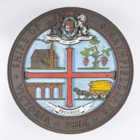
Sign - Shire of Strathfieldsaye Coat of Arms
The district of Strathfieldsaye was proclaimed in 1861 and named a Shire on the 17th September in 1866. It remained a shire until amalgamation in 1994 when it became part of the City of Greater Bendigo. The shire was located 8 km to the south- east of Bendigo and covered an area of 601 square kilometres and extended from the Calder Highway to the Coliban and Campaspe Rivers. The shire's administration centre was in Strathfieldsaye until 1972 when new offices were opened in Kennington. This coat of arms was commissioned for the front of the shire hall building.Brass painted coat of arms or emblem within a circle of the Shire of Strathfieldsaye. Outer rim contains text: SHIRE OF STRATHFIELDSAYE VICTORIA 1866 with the shield of the monarch of the United Kingdom centre top. The shield is divided into four parts with images reflecting the leading industries of the time; wine growing, mining, farming and tanning. The motto PROGRESS is depicted lower centre of shield. SHIRE OF STRATHFIELDSAYE / VICTORIA / 1866 / PROGRESSshire of strathfieldsaye, city of greater bendigo amalgamation, city of greater bendigo signs -
 Tarnagulla History Archive
Box of Donald Clark's Research Notes, Donald Clark's Research Notes, circa 1960s-2000s
Donald Clark Collection. Blue-grey archive box containing research notes of Donald Clark. Within this set are multiple archival folders with the following subject matter: Hotels Gold, prospecting & mining Peace Picnic Street lighting Churches Cemetery Poems Shire of Bet Bet Chinese Clubs Police Transport Local businesses/premises Local people Post Offices Previous history work / previous history enquiries Back To Tarnagulla events Victoria Theatre / Entertainment Schools Water and waterways Early town Mapping and geography Photocopies of photos Miscellaneous Rail Link Centenary Newbridge Eddington Waanyarra Bet bet (town) Llanelly Murphy's Creek / Irishtown Laanecoorie Military Service Fire Brigade Tarnagulla Landmarks / Places of Interest Family Histories Births, Deaths, Marriage info Transcript of St. Saviour's Records A plastic pocket containing duplicate copies of local history images held elsewhere in the collection. The contents of these files were research notes compiled by Donald Clark from his local history research about Tarnagulla and district. tarnagulla & district, donald clark, research -
 Wodonga & District Historical Society Inc
Photograph - Wodonga Civic Centre 1986
In the late 1960s the area in Wodonga between Hovell and Havelock Streets was zoned for civic purposes. By 1969 Melbourne architect Bruce Marshall had designed the civic centre which included a library, theatre and senior citizens' rooms. The main hall had a seating capacity of 1,000 people but could be divided by a sliding door. into smaller areas. It also included meeting rooms and kitchen facilities. The Civic Centre was officially opened by the Honorable Sir Henry Bolte, K.C.M.P., M.P., Premier of Victoria who was accompanied by the Honorable R. J. Hamer E.D., Minister for Local Government. The Shire President was Cr. James A. Terrill, J.P. In 1973, the Council engaged Bruce Marshall to design new offices beside the Civic Centre. Jennings Industries were contracted to complete the offices. The Governor, Sir Henry Winneke, laid the foundation stone of the new offices on 10 March 1976. The Civic Centre was demolished in 2011 to make may for a new $10 million community and entertainment centre which opened in August 2012.This image records an important stage in the development of local government and civic buildings in Wodonga, Victoria.A large framed image of Wodonga Civic Centre after it was upgraded in 1981wodonga history, wodonga civic centre, wodonga civic and government buildings -
 Wodonga & District Historical Society Inc
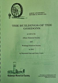
Booklet - The Buildings of the Gordons
... in High Street, Wodonga, Old Tallangatta Shire Offices and Butter ...John Gordon was born in Chelsea, London in 1826. He and his wife Eliza migrated to Australia in mid-1853. They settled originally in Sydney where John practiced his profession of carpenter. By 1868 John was advertising himself as an architect. In May 1876 he and George Sheppard of Wagga announced they had entered into partnership, adopting the name "Gordon and Sheppard". John drowned in the Murrumbidgee River at Wagga on the 19 December 1880 when aged 54, leaving a wife Eliza, two sons William Joseph and Charles Goodwin and a daughter, Ada Martin. In 1881 William and Charles established the firm Gordon & Gordon. Gordon & Gordon's practice initially covered southern Riverina, however by 1890 it was very Victorian orientated having offices in Melbourne, Corowa, Rutherglen, Mansfield, Benalla, Euroa, Wangaratta, Albury, Seymour and Wodonga. This publication documents many of the buildings designed by William and Charles Gordon, including images of many of them. Some of the more well-known ones were St. Patrick's Church in Albury, Fairfield villa at Brown’s Plains for G F Morris, the Wodonga Shire Hall of 1890, A. Schlink's Store in High Street, Wodonga, Old Tallangatta Shire Offices and Butter Factory, St. Joseph's Convent, Wodonga, "Cambourne" and the de Kerilleau Homestead.An A4 size spiral bound publication detailing the work of John Gordon and his sons William and Charles. It includes a speech transcript as well as articles and images.John Gordon was born in Chelsea, London in 1826. He and his wife Eliza migrated to Australia in mid-1853. They settled originally in Sydney where John practiced his profession of carpenter. By 1868 John was advertising himself as an architect. In May 1876 he and George Sheppard of Wagga announced they had entered into partnership, adopting the name "Gordon and Sheppard". John drowned in the Murrumbidgee River at Wagga on the 19 December 1880 when aged 54, leaving a wife Eliza, two sons William Joseph and Charles Goodwin and a daughter, Ada Martin. In 1881 William and Charles established the firm Gordon & Gordon. Gordon & Gordon's practice initially covered southern Riverina, however by 1890 it was very Victorian orientated having offices in Melbourne, Corowa, Rutherglen, Mansfield, Benalla, Euroa, Wangaratta, Albury, Seymour and Wodonga. This publication documents many of the buildings designed by William and Charles Gordon, including images of many of them. Some of the more well-known ones were St. Patrick's Church in Albury, Fairfield villa at Brown’s Plains for G F Morris, the Wodonga Shire Hall of 1890, A. Schlink's Store in High Street, Wodonga, Old Tallangatta Shire Offices and Butter Factory, St. Joseph's Convent, Wodonga, "Cambourne" and the de Kerilleau Homestead.gordon and gordon architects, building albury & wodonga -
 Wodonga & District Historical Society Inc
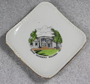
Memorabilia - China Souvenir Plate Shire Chambers Wodonga, Westminster Fine China Australia, C. 1957 - 1962
After meeting for 14 years in rented premises, in the Prince of Wales Hall, Wodonga Council built its first Shire Hall on the corner of High and Elgin Streets in 1890. The first Shire Hall was demolished in 1971. The second building, Wodonga’s new Municipal Offices in Woodland Grove were used for the first time by Wodonga Councillors on 7th August 1957. The Woodland Grove building has since been used for a range of purposes, most recently as a café, but is currently unoccupied. The third purpose-built council chambers were opened in November 1976 with the first council meeting there on 1st December 1976. Westminster Fine China Australia started in the Melbourne suburb of Cheltenham at 7 Arnold Street, in 1954 by Stanley Rogers and Son Ltd. They initially used imported blanks from Japan, which were made to their specifications, and which were then decorated locally. They produced a standard range of shapes for souvenir ware, later expanding into a wide range of tea sets, dinnerware and many other styles of china ware. The Abbey mark, based on Westminster Abbey in London, was used from the start of production until about 1962.Woodland Grove was named in honour of Wodonga Shire’s first president, John Woodland. The building depicted served as the centre of municipal government for approximately 20 years, throughout the 1960s and 1970s. Woodland Grove is a central point in the Wodonga CBD and a focus for many civic and cultural activities.Small square plate with gold trim and central coloured image of Wodonga Shire Chambers. The trademark of Westminster Fine China Australia is on the under side of the plateOn front beneath image "SHIRE CHAMBERS WODONGA VIC" Underneath the plate, surrounding an drawing of Westminster Abbey "FINE CHINA/WESTMINSTER CHINA /AUSTRALIA/ 7" municipal offices, woodland grove wodonga, souvenirs, westminster china -
 Charlton Golden Grains Museum Inc
Photograph, Globe Hotel c. 1987, c.1987
Globe Hotel, High St Charlton, established 1874 by John Walsh. This is the third building on the site. The first was destroyed by fire and rebuilt. It was then rebuilt as a two-storey hotel in 1940. It closed as a hotel in the early 1970's and became offices and flats. The Charlton Gentlemen's Club on the RH side was established in 1900. Photo is part of a series of streetscapes taken in 1987 for the Charlton Shire. Globe Hotel third (building) established 1874 as single storeyed and Charlton Gentlemen's Club est. 1900. Globe destroyed by fire and rebuilt in 1940. In 1970's to became offices and flats.Colour photograph of two storey red brick building. Signage on the windows reads SOIL CONSERVATION AUTHORITY (not all words fully visible). A man on a cherry picker in front of building trimming a tree. Signage on the side of the white truck says North Central TRAVEL TOWER Hire. Two orange safety cones on the road. RH side is the single storey, glass-fronted building with a white-framed door. charlton, globe hotel, soil conservation authority, business, industry, agriculture -
 Charlton Golden Grains Museum Inc
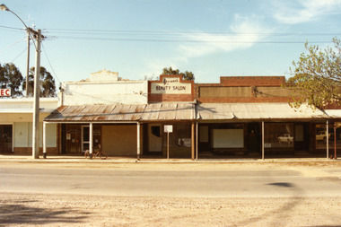
Photograph, Charlton High Street, west end, north side 1987, c.1987
West end, north side of High St Charlton. Part of Shire streetscape series 1987. From left, the buildings are; State Electricity Commission, Oakley Thompson Solicitors (formerly Dobson's), Yvonne's Beauty Salon (formerly Linda Hinsen's (?) Frock Shop, former 3CV offices (later J Knights Dentist, Arundell's Shoe Shop.Colour photograph of six shops at the west end, northern side of High St Charlton. Signage above one shop reads Yvonne's BEAUTY SALON. E.C signage for the S.E.C shop visible on LH side of photo. Bicycle leaning against middle verandah post. Large electricity pole on LH side of photo. Signage for Arundell's partially visible on RH side.state electricity commission, oakley thompson, dobsons, yvonnes beauty salon, 3cv, j knights dentist, arundells, business, industry -
 Lakes Entrance Historical Society
Photograph, Fish Marie, 1994
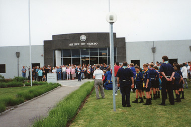
Shire of Tambo became part of East Gippsland Shire on amalgamation of all shires of East Gippsland.|Also one other colour photograph similar view.Colour photograph taken during the ceremony to mark the closure of the Shire of Tambo, taken at the offices on Palmer's Road, shows crowd at main entrance during speeches and socialising afterwards. Lakes Entrance Victorialocal government, local history -
 Eltham District Historical Society Inc
Photograph - Digital Photograph, Marguerite Marshall, Wingrove Cottage, Main Road, Eltham, 8 June 2006
Wingrove Cottage built 1858-1859 of hand made bricks is historically significant for its long association with Charles Wingrove, a prominent figure in Victorian local government, as secretary to the Eltham District Road Board and Shire Council from 1858 to 1904, and Shire Engineer and Secretary to the Heidelberg Road Board. The cottage was used as the office of the Eltham District Road Board and Council for many years It is one of the Shire's oldest dwellings, and one of the few surviving 19th century buildings associated with early Eltham and located in the original Eltham Village Reserve. The symmetrical planting of a pair of Pencil Pines (not visible in photo) is also historically and aesthetically significant as characteristic of the early period of planting in the district and because they are a distinctive landscape feature. In October 2002 new owners demolished the outbuildings attached to the rear of the cottage. Community protest at the demolition resulted in Council issuing a Stop Work order. The owner was issued with a court order in September 2003 to develop a conservation management plan and restore the heritage listed property. The owner sold the property in 2005 to Cameron Construction in 2005 who undertook the restoration work. In 2007 a planning application to build two offices and seven dwellings at the rear of the property was ultimately rejected. The cottage is now the main office for Cameron Construction. Covered under Heritage Overlay, Nillumbik Planning Scheme. Published: Nillumbik Now and Then / Marguerite Marshall 2008; photographs Alan King with Marguerite Marshall.; p57 Wingrove Cottage on Main Road beside Eltham Primary School, is one of the Shire’s most important historical buildings and was central to local government for almost 50 years. The cottage was built in stages from 1858 to 1888 for Charles Symons Wingrove JP. He was the Eltham District Road Board’s first paid secretary and later the Shire Secretary when the board became the Eltham Shire Council. Wingrove held those positions, and that of engineer for a time, for 46 years. He was also one of the main figures in the Municipal Association of Victoria. As Eltham’s first paid municipal officer, Wingrove used one room in his 11 – (originally two) roomed home, as the office for the board then the council. Meetings were held there from the late 1850s (as well as at more central locations) until Wingrove’s retirement in 1904. The cottage is a rare example of a local government office occupying a Road Board /Shire Secretary’s purpose-designed house. The cottage is also significant because it is the oldest largely intact building from the original Eltham township reserve (south of Dalton Street).1 The township had its origins in the 1848 Nillumbik Parish Plan and was one of the state’s earliest township reserves. The rectangular house of handmade bricks, roofed with grey slate tiles and with a veranda encompassing three sides, is reminiscent of those in the central goldfields including Castlemaine. Its overhanging eaves and gables were unlike houses in Melbourne at the time. Wingrove, who was born in 1827, had been a gold digger and a road surveyor. Impossible to imagine in today’s world, Wingrove was also the Shire of Heidelberg’s secretary and engineer for part of the time that he was secretary in Eltham. Living next door to the primary school was a mixed blessing. Wingrove and his wife Katherine, who had ten children, sent their eight surviving children to the school. But they had occasional disputes with the school authorities when their cattle wandered into the schoolyard. Eltham showed Charles Wingrove its appreciation of his services by giving him two illuminated addresses, one after ten years and the other at retirement. Wingrove died in 1905 aged 76 and was buried in the St Katherine’s Church of England cemetery in St Helena. His grave is surrounded by those of family members including his wife, Katherine and two babies, Henry, 12 months and Isobella, 15 months, who died in the mid-1860s. Cottage ownership passed to his wife, then to daughter Caroline and then to daughter Bessie, a Melbourne University graduate and artist. During the Great Depression their brother Walter was the ratepayer. At one stage the Wingrove property extended to Metery Road and included a small creek. The family ran a small dairy and orchard, with associated farm buildings, which were later removed. In 1949 part of the property was compulsorily acquired by the Eltham Primary School, which infuriated owner Bessie Wingrove. She protested in a letter about this ‘monstrous act of unmitigated tyranny’.2 She was the last Wingrove to occupy the cottage and died in 1955. Wingrove descendants sold the house in 1974 and the property was subdivided. In the 1960s the Eltham Shire named the park opposite the cottage in Wingrove’s honour. The cottage has since had several owners including psychiatrist Dr Daniel Kahans, who practised there. In October 2002 late rear additions which had been substantially altered were demolished contrary to council planning controls. This caused a community outcry and resulted in legal proceedings against the owner. Fortunately the historical significance of the demolished section was not as great as the older front part of the building, which has been retained and was later restored.This collection of almost 130 photos about places and people within the Shire of Nillumbik, an urban and rural municipality in Melbourne's north, contributes to an understanding of the history of the Shire. Published in 2008 immediately prior to the Black Saturday bushfires of February 7, 2009, it documents sites that were impacted, and in some cases destroyed by the fires. It includes photographs taken especially for the publication, creating a unique time capsule representing the Shire in the early 21st century. It remains the most recent comprehenesive publication devoted to the Shire's history connecting local residents to the past. nillumbik now and then (marshall-king) collection, cameron construction, charles symons wingrove, eltham, eltham road district board, eltham shire council, main road, wingrove cottage -
 Whitehorse Historical Society Inc.
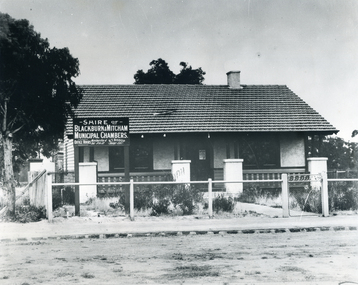
Photograph - B/W Photograph, Municipal Chambers - Shire of Blackburn & Mitcham - First Office
When the Shire of Blackburn and Mitcham was proclaimed on 27th May 1925, the second meeting of the Shire was held in the hall of the Methodist Church on Monday 28th September 1925 at 7.30pm.|Three ensuing meetings were also held there and following meetings were at the dwelling in Whitehorse Road, which was purchased by the Shire for use as their office. (By Coincidence this dwelling was almost on the site of their new Municipal Offices.)Black and white picture - Municipal Chambers of Shire of Blackburn & Mitcham located opposite the present offices of City of Whitehorse in Whitehorse Road, Nunawading|See also NP35 & NP36 after it was destroyed by fire.municipal chambers - first office, shire of blackburn and mitcham, whitehorse road, nunawading, methodist church