Showing 101 items
matching arthur taylor
-
 Bendigo Historical Society Inc.
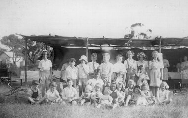
Newspaper - JENNY FOLEY COLLECTION: STYLISH
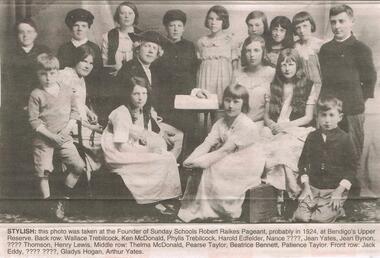
Bendigo Advertiser '' The way we were'' from 2002. Stylish: this photo was taken at the Founder of Sunday Schools Robert Raikes Pageant probably in 1924, at the Bendigo's Upper Reserve. Back row: Wallace Trebilcock, Ken MacDonald, Phylis Trebilcock, Harold Edfelder, Nance ?, Jean Yates, Jean Bynon, ? Thomson, Henry Lewis. Middle row: Thelma MacDonald, Pearse Taylor, Beatrice Bennett, Patience Taylor. Front row: Jack Eddy, ??, Gladys Hogan, Arthur Yates. The clip is in a folder.newspaper, bendigo advertiser, the way we were -
 Bendigo Historical Society Inc.
Document - THE MAYORAL AUXILIARY, 25 Sept. 1947
The Mayoral Auxiliary. Entertainment arranged by The Mayoral Auxiliary in aid of The Food For Britain Appeal. 25 Sept., 1947. Part 1 - Musical Programme. 1.Piano & Violin: Misses Leggo & McNair. Vocal Solo: Mr Arthur Nicholls. Trio: Mesdames Ennor & Lober & Miss Pianto. Dramatic Scene, Song & Dance: Miss Janice Morgan. Vocal Solo: Mr Beckwith. Specialty Act: Miss Gladys Brown. Vocal Solo: Mrs Ennor. Part 2 - Dramatic Entertainment. Dramatic Personage: Dreamer: Mr Jack Hocking. Grandparents: Mr Mac Walker & Mrs Oliver. Suitors: Messers Beckwith & Harvey. Daughter: Miss Letty White. Dancer: Miss Eileen Clarke. Sports Girl: Miss Mary Stanistreet. Marie & Mary: Misses A Taylor. The Cook & the Lady: Misses Dorothy Farmer & Helen Sargeant. Widow: Miss Beverly Dyer. Sister: Miss Judy Edwards. Bride: Miss Phyllis Farmer. Nanny & the Children: Mrs T O Hunter, Misses Janice Morgan & Gladys Brown. Nurses: Misses D Farmer & Helen Sargeant. Orchestra: Misses Leggo (Piano); McNair (Violin) & Kerr (Viola). Costumieres: Mr & Mrs L V Lansell. Cake Stall: Mesdames Amer, Bryenton & Poulston. Sweets: Mesdames Chellew & Guthery. Sellers: Girls School Students. Doorkeepers: Mesdames Anderson and Streader. Sweets supplied by Girls School, High School, Mr Wilkinson, Mrs Body, Misses Burgess & Weller. Tickets donated by Mr Albert Matthews. Stage Manager: Mrs T O Hunter. Compere: Mess L MacGillivray. Assistant: Mr L M Green. 3 copies of program 4268 a,b,c. 4 pages.entertainment, theatre, the mayoral auxiliary, the mayoral auxiliary in aid the food for britain appeal. 25 sept., 1947. piano & violin: misses leggo & mcnair. vocal solo: mr arthur nicholls. trio: mesdames ennor & lober & miss pianto. dramatic scene, song & dance: miss janice morgan. vocal solo: mr beckwith. specialty act: miss gladys brown. vocal solo: mrs ennor. dramatic personage: dreamer: mr jack hocking. grandparents: mr mac walker & mrs oliver. suitors: messers beckwith & harvey. daughter: miss letty white. dancer: miss eileen clarke. sports girl: miss mary stanistreet. marie & mary: misses a taylor. the cook & the lady: misses dorothy farmer & helen sargeant. widow: miss beverly dyer. sister: miss judy edwards. bride: miss phyllis farmer. nanny & the children: mrs t o hunter, misses janice morgan & gladys brown. nurses: misses d farmer & helen sargeant. orchestra: misses leggo (piano); mcnair (violin) & kerr (viola). costumieres: mr & mrs l v lansell. cake stall: mesdames amer, bryenton & poulston. sweets: mesdames chellew & guthery. sellers: girls school students. doorkeepers: mesdames anderson and streader. sweets supplied by girls school, high school, mr wilkinson, mrs body, misses burgess & weller. tickets donated by mr albert matthews. stage manager: mrs t o hunter. compere: mess l macgillivray. assistant: mr l m green. -
Bendigo Historical Society Inc.
Document - TOWN HALL, THE BENDIGO CHORAL SOCIETY, 24 Apr 1928 - 27 Nov 1928
Town Hall, The Bendigo Choral Society. 3 Programs for 1928: First Concert, Second Concert & Third Concert. a/ First Concert 38th Grand Concert, Town Hall, Bendigo. Tue. April 24th, 1928. Conductor MR W C Frazier ARCO. Artists: Miss A Caddell, Mr L Bienvenu. Pianiste: Miss Eileen Hains, ATCL. Hon. Sec. E H Collett. Asst. Sec. W F Mansell. Other Artists from BCS; Miss Essa McSwiney, Miss Jean Thompson, Miss May McGauchie, Hector Taylor. Programme: Price 3d. Programme: In These Delightful Pleasant Groves, Like To A Damask Rose, When The King Went Forth To War, Lament Of Isis, Tell I Tell Me, The Princess, Autumn's Storms, Prelude (The Cycle of Life), How Fair is Thy Face, God's Son Hath Set Me Free, Jesus Christ Our Lord Is Risen, I Heav'n Above, King Arthur. b/ The Bendigo Choral Society, Season 1928. Second Concert. 39th Grand Concert. Town Hall, Bendigo. Wednesday, Sep. 19th 1928. Conductor: Mr W C Frazier ARCO. Sub-Conductor: Mr E A Miller. Artists: Coral Trenerry, Muriel Bolt, Leslie Jephcott, Eileen Hains, Bendigo Choral Society. Hon. Sec. E H Collett. Asst. Hon. Sec. W F Mansell. Programme: The Hexhamshire Lass, Prelude and Allegro, M'Appari Tutt 'Amor', Rhapsody, Sweet Stay Awhile, There is a Lady Sweet and Kind, Danse Negre, Study, Merry Andrew, Gracious and Kind Art Thou My Queen, Secrecy, Sweet Honey-Sucking Bees, Mazurka, Sigh No More, Faery Song, Fantasie, Courage Brothers. Picture of W C Frazier is on cover. c/ The Bendigo Choral Society. Season 1928. Third Concert. 40th Grand Concert. Town Hall, Bendigo, Tuesday, November 27th, 1928. Conductor: Mr W C Frazier. Artists: Gwen Prockter, Lotte Daniell, A E Sayer, Eileen Hains ATCL, Joyce Connell LTCL. Hon. Se. E H Collett, Asst. Hon. Sec. W F Mansell. Programme 3d.Programme: Rest Sweet Nymph, Fine Knacks for Ladies, Adagio, Allegro, The Maiden's Complaint, I've Been Roaming, Down in a Valley, Flora Gave Me Fairest Flowers, Gipsy Dance, Songs of Love, Elegie, Songs of Love, Moonlight, The Nut-Tree, Songs of Love, Traumerei, Zigeunertanz, Nymphs and Fauns, Romance, Budmouth Dears, Bonny Fisher Lad, Rolling Down to Rio.Boltons Print, Bendigoprogram, music, the bendigo choral society, town hall, bendigo, the bendigo choral society. 3 programs for 1928 a/ first concert 38th grand concert. tue. april 24th, 1928. conductor mr w c frazier arco. artists: miss a caddell, mr l bienvenu. pianiste: miss eileen hains, atcl. hon. sec. e h collett. asst. sec. w f mansell. other artists from bcs; miss essa mcswiney, miss jean thompson, miss may mcgauchie, hector taylor. programme: in these delightful pleasant groves, like to a damask rose, when the king went forth to war, lament of isis, tell i tell me, the princess, autumn's storms, prelude (the cycle of life), how fair is thy face, god's son hath set me free, jesus christ our lord is risen, i heav'n above, king arthur. b/ second concert. 39th grand concert. wednesday, sep. 19th 1928. sub-conductor: mr e a miller. artists: coral trenerry, muriel bolt, leslie jephcott, eileen hains, bendigo choral society. hon. sec. programme: the hexhamshire lass, prelude and allegro, m'appari tutt 'amor', rhapsody, sweet stay awhile, there is a lady sweet and kind, danse negre, study, merry andrew, gracious and kind art thou my queen, secrecy, sweet honey-sucking bees, mazurka, sigh no more, faery song, fantasie, courage brothers. picture of w c frazier is on cover. c/ the bendigo choral society. season 1928. third concert. 40th grand concert. town hall, bendigo, tuesday, november 27th, 1928. conductor: artists: gwen prockter, lotte daniell, a e sayer, eileen hains atcl, joyce connell ltcl. programme: rest sweet nymph, fine knacks for ladies, adagio, allegro, the maiden's complaint, i've been roaming, down in a valley, flora gave me fairest flowers, gipsy dance, songs of love, elegie, songs of love, moonlight, the nut-tree, songs of love, traumerei, zigeunertanz, nymphs and fauns, romance, budmouth dears, bonny fisher lad, rolling down to rio. -
 Bendigo Historical Society Inc.
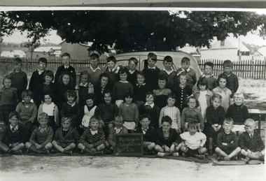
Photograph - GOLDEN SQUARE STATE SCHOOL COLLECTION: BENDIGO COMPETITIONS 1941, 1941
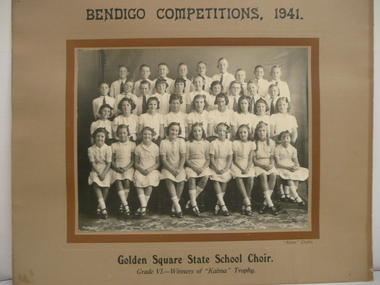
Black and white photograph mounted on card, Golden Square State School Choir Grade VI Winners of Kalma Trophy Bendigo Competitions 1941, with list of names attached to back. Fourth row from left: Fred Allen, Arthur Sullivan, Leigh Anquetil, Len Thirlwell, Bill Stevenson, Walter Randall, George Watt, Keith Taylor, Murray Woodman. Third Row: Fred Foon, Arthur Dixon, Stan Sullivan, Jean Guy, Unknown, Margareta Tuff, Barbara McIvor, Norm Priddle, Graeme Warne, John Meager. Second row: Csaryl Hammill, Ruby Crofts, Nora Willcocks, Lois Goodwin, Betty oldham, Margaret Withworth, Nancy Tarr, Joyce Pozza, Joan Dresder. Front row: Barbara Mamouney, Ruth Bull, Mary Watt, Arlene Matthews, Valerie Potter, Jean Cooper, Joy Porter, Lorna Browell, Margaret or Joan Sullivan.Kalma Studiosbendigo, education, golden square primary school -
 Bendigo Historical Society Inc.
Document - BILL ASHMAN COLLECTION: CORRESPONDENCE
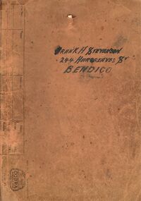
Dull orange folder containing copies of letters, brochures, information sheets and some newspaper cuttings. Name on the front is Frank A. Stevenson 244 Hargreaves St Bendigo. Letters date from 1937 to 1942. Newspaper titles include: Prevention of Rust- Principle of the Scalebuoy, Scalebuoys in Cars, Tragic Death of Captain Hartley Abbott and the Obituary of Captain R.H.S.Abbott.sciences, instruments - general, scalebuoy, bill ashman collection - correspondence, frank a stevenson, mr bacon, amalgamated freezing co bendigo, g whalley, gunbower co-operative butter factory & trading coy ltd, mr wallace, j charlesworth, d v evershed, bendigo electronic co, walshes crown hotel, hunter bros, wybgones unit, 180 gold mining co, o'hallorans cyanide unit, crystal ice works, stevenson unit, bendigo council, central nell gwynne, nth deborugh g m co, deborugh g m c, deborugh consolidated, cohuna butter factory, geo ross, victorian producers' co-operative coy ltd, h abbott, ernest f o liddell, rothacker bros, motor spares ltd, leggo's buildings, t j jorgensen, mr robinson, stevenson bros, r h s abbott, d c house, the electrical factor in metabolism, w n abbott, the great boulder proprietary gold mines ltd, w o galletly, mr stronell, newport workshops, victorian railways, mr brownbill, mr james, the university of melbourne, j l osborne, n clarkson, sister mary gonzaga, st joseph's hospital, mater misericordiae hospital, mr herzog, sister m monica?, vacuum oil, j johns, h j grigg, w a walsh, market square, crown hotel, g e cole, transport & engineering in australia 16/12/1937, mr menderson, mr ross, sanitary age 8/2/1935, northern kiwanis clubs, harry a baxter, w h cunningham & hill ltd, link-belt co ltd, sir william crooks, royal zoological society, ginna works germany, close brothers, w h taylor, geo taylor hardware co ltd, details of hydraulic spinner unit (scalebuoy), a davidson, john g kelly inc, hannon, myers wishart, kennedy, mr critten, pennsylvania rubber coy, paul a douden & co, w e humphrey, kansas city public service co, smith, tangney hotels, wahkonsa hotel, muscatine hotel, arlington hotel, burke hotel, helen tangney-springer, f w woolworth co, w w edan, ymca, n f alcock, b j ingram, scalebuoys, bendigo electronic company of australia proprietary limited, a s bloomfield, harry ponsonby mackenzie, arthur robinson & co, the commercial banking company of sydney ltd, a t madden, victorian railways, e c eyers, city of bendigo, frank h day, lane's motors pty ltd, h c holland, union oil soap & candle co ltd, knox home, n a duthie, w h mccorkindale, maungatapere co-op dairy co ltd, the whangarei co-op dairy co ltd, w h millingford, kettering cartons limited, j g arlidge, w e humphrey, kansas city public service company, h w smith, prospectus of scale buoy distributors limited, edwin gripper banks, richard hartley smith abbott, frank shaw fitchett, hayden smith & fitchett, the commercial bank of australia limited, william john stanley horsfall, frank cooper, scott's hotel, a j phillips, stringer & phillips proprietary ltd, e g banks, edwin gripper banks, reginald william stringer, frank cooper, claude gordon robinson, s reid -
Port Melbourne Historical & Preservation Society
Photograph - Debutantes, St Joseph's, Port Melbourne, 1950s
St Joseph's deb photo mid-late 1950s. religion - roman catholic church (st josephs), celebrations fetes and exhibitions, les hetherton, pat o'reilly, arthur seeley, george mallett, chris watson, graham taylor, alice rowlands nee burke, judy ferris -
Port Melbourne Historical & Preservation Society
Book, Terry Keenan, A Taste of Port, Apr 1999
Researched for years by the author, who has also researched the PMCC (for which he played and later was for some years President)(.01)'A Taste of Port - Personal Profiles, snapshots and statistical records drawn from the history of the Port Melbourne Football Club' by Terry KEENAN. Red and blue paperback 1999, signed by author. (.02) Letter to Martin FLANAGAN - writer for "The Age" - from Terry KEENAN regarding the Prahran Football Club. Letter is inside back cover of above book.Signed 'Terry Keenan' on title pagesport - australian rules football, societies clubs unions and other organisations, terry keenan, norm goss snr, norm goss jnr, denise goss, kevin goss, paul goss, michael goss, lilian 'lil' goss nee johnson, goss family, tommy lahiff, vic aanensen, frank johnson, george ogilvie, billy henneysee, billy fraser, jack hutchinson, john croft, george taylor, bob merrick, bill bedford, ron bedford, ted freyer, bob bonnett, alma football club, graeme anderson, ron barassi, william 'bill' barfoot, jack mcmurray, alexander harold james howlett, joe garbutt, billy mcgee, arthur knox, bob skilton jnr, bob skilton snr, port melbourne football club, pmfc, j kitchen & sons pty ltd, fred cook -
 Port Melbourne Historical & Preservation Society
Book, Terry Keenan, "In Safe hands: Presidents of the Port Melbourne Football Club", 2011
"In Safe hands: Presidents of the Port Melbourne Football Club", by Terry KEENAN. describes the 29 presidents of the Port Melbourne Football Clubcyril letts, richard taylor, william swallow, peter saultry, albert victor renowden, sport - australian rules football, thomas swallow, carl frederick julius seismann, john finlay malcolmson, frederick thomas derham, george sangster, arthur tate, arthur hester, franz opitz, george alexander rogers, james peter crichton, william harper, arthur hardingham, hugh stranaghan, henry lang, walter 'watty' power, thomas griffin, joseph earle, albert garbutt, henry perazzo, james mutch, norm goss snr, henry harrison, john bradley, port melbourne football club, pmfc, alexander arthur james -
Port Melbourne Historical & Preservation Society
Photograph - Class 8, Nott Street School, Nott Street Class VIII 1941, 1941
Norma and Ruth ? (twins)Lasercopy of Nott Street School photograph, class 8 of 1941'Nott St School 1427 VIII 1941'education - primary schools, arthur keeping, ray gibbons, jack boyden, frank brennan, george taylor, fred perazzo, alan mccarthy, ken hudson, alan turner, fred cooper, betty wooley, betty lyons, joyce jenkinson, pearl nicol, joyce renfrey, hodges, kenny hennessy, alma rowe, betty watt, reba wright, joan jarvis, moya hannan, shirley rochford, pat andrews, june cooper, vic thompson, irene birch, nancy brown, beryl hall, norma ?, ruth ?, joyce irving, sylvia craig, dorothy richardson, ron egaroff, amy mick, len chiviers, wally myers, percy carter, jimmy lewis, fred billings, jack timms, bobby newman, ron bedford, ron stephenson, nott street state school -
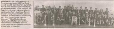 Bendigo Historical Society Inc.
Newspaper - JENNY FOLEY COLLECTION: BIG BRASS
Bendigo Advertiser "The way we were" from Saturday, July 17, 2004. Big brass: the Eaglehawk bandat Echuca showgrounds, 1937-38. Back row left to right: Stan Croshan, Suna Tab, Alex Hunter, Whistler Christy, Stan Finch, Snowy Holingshead, Frank Sullivan, Ted Taylor, drum major George Miller, band master Ted ?, Les Gray, Tommy Broman, Harry Truscott, Stan Jackson. Front row: Bob Henderson, Frank Davey, Alf ?, Tom Brown, Arthur Sullivan, drummer, Unknown, Mick Morton, George Porter, Arthur Morton, Eric Hawkins, Harold Pithie, Albert Miller and Rob Porter.newspaper, bendigo advertiser, the way we were -
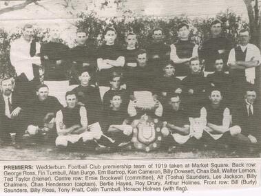 Bendigo Historical Society Inc.
Newspaper - JENNY FOLEY COLLECTION: PREMIERS
Bendigo Advertiser "The way we were" from Tuesday, April 19, 2005. Premiers: Weddeburn Football Club premerieship team of 1919 taken at Market Square. Back row: George Ross, Fin Turnbull, Alan Burge, Ern Bartrop, Ken Cameron, Billy Dowsett, Chase Ball, Walter Lemon, Ted Taylor (trainer). Centre row: Ernie Brockwell (committee), Alf (Tosha) Saunders, Les Jackson, Billy Chalmers, Chas Henderson (captain) Bertie Hayes, Roy Drury, Arthur Holmes. Front row: Bill (Burly) Saunders, Billy Ross, Tony Pratt, Colin Turnbull, Horace Holmes with flag.newspaper, bendigo advertiser, the way we were -
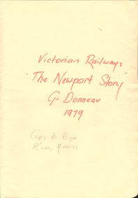 Bendigo Historical Society Inc.
Document - VICTORIAN RAILWAYS - THE NEWPORT STORY
Typed history of the Newport Railway Workshops. Mentions the men who worked at the workshop, the locomotives that were built there, the different classes of locomotives, the equipment they used, and some of the work they did. Written by G. Donneau (who worked there) and dated 19-3-79.document, victorian railways, the newport story, g donneau, melbourne and geelong railway co, melbourne & hobson's bay united railway co, mr william meikle, solomon mirls, richard speight, sir james allport, midland railway, mr allison dalrymple, phoenix foundry, north melbourne loco depot, beyer peacock & co, mr a e smith, roger barnes, thomas tait, bhp, f j shea, commonwealth ordnance department, james rooks, london times, mr merz, mr mclellan, bendigo north railway workshops, ballarat shops, james taylor, donald mcgregor, julius aurelian sylvester barber, victor lethlean, melbourne institute of technology, prince of wales, queen victoria, w m shannon, sir thomas bent, puffing billy, harold winthrop clapp, francis boardman clapp, melbourne tramway & omnibus co, austral otis engineering co, melbourne university, franklin supply co, e h brownbill, heavy harry, locomotive mausoleum north melbourne, north british locomotive co, walter stinton, thomas smith, peter alexander, peter alexander, robert ferguson, king george v, english railway gazette, harry nunn may, merz & maclellan, arthur lowe, r h roach, w h chapman, l c rolls, g a swift, john mcrae, caledonian society, thistle club, bristol hotel, james taylor, george allibon, walter grimshaw, robert maybin, roy hodge, walter biddle, john ramsbottom, robert hewitt, james green, thomas waldhuter, giles dobney, mr richardson, mr arthur, sydney express, the age, mr speight, david syme, father gapon -
Tatura Irrigation & Wartime Camps Museum
Certificate of Title, Subdivisions, 1879 and 1930
Title Deeds for property in Tatura2 certificates of title showing subdivisions made over several years. Vol. 5655:Folio 1130935 dated 16/5/1930 and Vol.1182: Folio 236330 dated 23/12/1869. Lease between Thomas Hogan and W F Bazeley dated 7th July 1911 for land in Hogan Street known as Slaughter Yard Paddock .Also lease dated 1911. In buff coloured legal envelope with number "2678" and "Hogan - Thomas" written in red on outside.tatura, relationship folders, certificate of title, lease, thomas hogan, john hogan, john james hanlon, edward glover, arthur burke, james brady, andrew collie, jean hunter, sydney embling, john maher, arthur goyen, patrick o'toole, philipe dove, george wildon, edwin harden, cuthbert corke, lee chung, hugh barnes, george manning, francis williams, john fawkner, michael walshe, alexander ferguson, rose gullett, john gibb, william taylor, richard casey, anthony grover, arthur grover, charles brady, elizabeth davey, frank williams, honora culkin, alexander park, stephen reville, richard carr, charles grover, henry mccarthy, james bruce, edward hanley, chew yen, ah poy, loo way, ah dick, charles mitchell, lionel martin, douglas forsyth, catherine wilson, mabel heath, patrick mcnamara, micheal cussen, james wilson, bazeley, documents, legal -
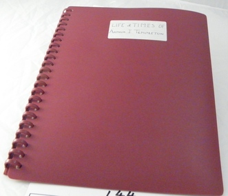 Sunshine and District Historical Society Incorporated
Autobiography, Life and times of Arthur J. Templeton
Autobiography as told by Templeton, Arthur John. Typed and edited by David Templeton (Arthur's brother) from November 1991-July 1992.Typescript in a maroon display book with a maroon binding. Contains autobiography of Arthur J. Templeton.LIFE & TIMES OF ARTHUR J. TEMPLETONarthur j. templeton, birth 1923, sunshine harvester co, h. s. taylor, waterloo ontario canada, apprenticeship, family, work in tasmania, president chamber of manufactures, leisure. -
 Stawell Historical Society Inc
Photograph, Ledcourt School Students in front of shelter
Back 'Left Shirley Walker, Arthur Clarke, Mervyn Launder, Freddy Howard, Bill Cunningham, Lorraine Pickering, Sylvia Launder, Joan Clark, Anne Taylor, May Cunningham(Standing). Front: Stan Pickering, Mervyn Pickering, Dorothy Launder, Alf Taylor, Neville Howard, Cunningham, Beverley Rosenow, Maragret Howard, Ian Howard, ??, Laura Howard, Pauline MOrgan "??' Cunningham, ? < Margaret RallyLadies with tables in background of student and young infants in two lineseducation -
Stawell Historical Society Inc
Photograph, Students of Pleasant Creek Training Centre 1950's
Bob Smith, Gordon Prior, Bill Kelly, Kath Delahunty, Margaret Forsyth, Peter Woods, Matron Carter, Matt Lynch, Miss Burnside, Ira Carter, Smart, Haywood, Irene Peters, John Scarlatti, Mavis Taylor, Brian Winks, Ray Squire, Lillian Haughton, Maureen Karline, Brian Siggins, Ken Thompson, Lindsay Thompson, Arthur Young, Brian Clugson, Bev Berry Students and Staff at Pleasant Creek Training Centre late 1950'seducation, students -
 Whitehorse Historical Society Inc.
Document - Land Title, Transfer of Land
Photocopy of transfer of land in Vermont (2 pages)morton, william, taylor, maclare, john, griffett, henry, finlayson, florence isabella, laura helen, lemmon, macgibbon, elizabeth corsar, elms, marie, arthur william, mccoll, hilda guthrie -
Whitehorse Historical Society Inc.
Newspaper - Article, Schwerkolt Cottage has history in a wine cellar - Schwerkolt wine cellar, 11/07/1973
'Schwerkolt Cottage has history in a wine cellar' : article on restoration and official opening of the Schwerkolt Cottage wine cellar.schwerkolt cottage, wine cellars, vermont winery, s. wynn & co ltd, taylor frank, councillors, mayors, patterson keith arthur -
 Whitehorse Historical Society Inc.
Photograph, Prep - Mitcham Primary - 1940, 1940
Black and white photograph of Prep grade (Grade 1A) of Mitcham Primary School in 1940. Davin's Dairy and stable in background at corner of Mitcham Road and Victoria Street. Back row - ????Sargeant, David McLean, ???????, John Robertson, Keith Jones, Herb Lilburn, Dave Jones, Jeff Ellis, Alfred Gadsen. 2nd Row - Dawn freeman, Clare Smith, Barbara Savage, Keitha Petty, Marjory Stonehorn, Judith Honeybun, ??????, Pat Flynn, Peggy Burns, Betty Dashwood, Norma Hennessy. 3rd Row - Thelma Burton, Irene Schafer, Robin Leeworthy, Maureen Webster, Barbara Spelling, Margaret Newing, Judith Gorsuch, Lorna Treverton, Valda Hancock, Marion Cumming, ??? Taylor. Front Row - Bill McCaulay, Graham Clements, John Colman, Vernon Osterlind, Arthur Charles, ???? Boyle, Keith Brown, Alan Smith, Micky Dee, Lawrence Petty.mitcham primary school, no. 2904, sargeant, lilburn, herb, jones, keith, robertson, john, mclean, david, dave, ellis, jeff, gadsen, alfred, freeman, dawn, hennesy, norma, dashwood, betty, burns, peggy, flynn, pat, honeybun, judith, stonehorn, marjory, petty, keitha, savage, barbara, burton, thelma, smith, clare, schafer, irene, taylor, cumming, marion, hancock, valda, treverton, lorna, gorsuch, newing, margaret, spelling, webster, maureen, leeworthy, robin, bill mccaulay, fry, lawrence, dee, micky, alan, brown, boyle, charles, arthur, osterlund, vern, colman, clements, graham -
 Rutherglen Historical Society
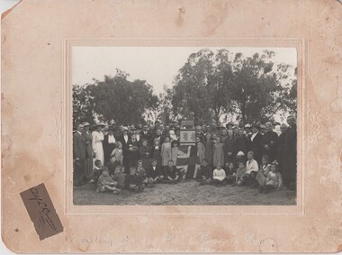
Photograph, Alf L. Bowden, 1918-1920 (Approximate)
Names of those in photograph (33 adults, 29 school children) are listed on verso of worksheet - Information from Mrs Murtagh.Photograph of Brown's Plains School unveiling Honour Roll, circa 1920. cardboard, unframed"Unveiling Honour Roll, Browns Plains / After 1914-1918 War"ivy fisher, dearie fisher, ernie beck, mrs j milthorpe, murray smith, ray milthorpe, mary stewart, edmund doolan, jim doolan, joe fisher, mrs c morris, mr c morris, w keeble, fred fisher, harry beck, tom fisher, jack milthorpe, j doolan, mrs mills, j flegg, mrs flegg, louis leseberg, dan whelan, mrs grace, mrs leseberg, daisy flegg, miss milligan, mrs doolan, ann whelan, mrs t fisher & babe, mrs robinson, rev taylor, leo doolan, hec mills, ted newbound, phon doolan, noel mills, norm newbound, jim milthorpe, lin whelan, muriel mills, arthur strahan, eileen grace, nora shelley, matt grace, gladys smith, madge whelan, alice keeble, julia whelan, charles milthorpe, mona newey, jessie hamilton, vonie shelley, daisy smith, mollie grace, eva keeble, artie ashton, tess grace, ernie newey, lyla smith, peggy milthorpe -
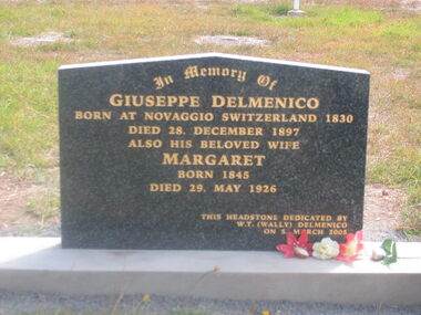 Ballarat Heritage Services
Photograph - Photograph - Colour, Guildford Cemetery
Headstones from the Guildford Cemetery. Headstones found in the cemetery include: ALFORD Phyllis Edith ANDERSON Phyllis Mary BARASSI Guiseppi, Jemima, Ann Conolly, Carlo Guiseppi, Carlo Guiseppi BAUD Catherine Edith BIRD Axel Jackson BISHOP George F, Elizabeth Futtrel BLACKMORE Lindsay Horace, Thelma Phyllis BLIGHT Edith Ann BLINKHORN Billinge, Amy Clark BOOTH Lyn BOURKE Gordon, Margaret BRANDON Janet Annie BYATT Elizabeth CANEVASCINI Vincenzo CARTER David, Ruth Vida CARTER Frank Noel CARTER Peggy Dawn CARTER Ruth, Strutten CASLEY George Alfred CERCHI Brian Maxwell CHAPMAN Stephen Henry James COX James, Sarah DARROCH Jennifer Anne DARROCH Robert Henry, Madge Annie DAVIES Marlene Kaye DAVIS Mark Richard DELL John, Anna DELMENICO Charles David, Robina May DELMENICO Giuseppe, Margaret DELMENICO Ivy May DELMENICO Jack, Adeline Marie DELMENICO Morris Charles DELMENICO Morris Vivian, Christina DELMENICO Pasqual Levio, Mary Ann DELMENICO Victor Guildford, Daisy Evelyn DELMENICO Victor M, Catherine DELMENICO Angelina (Quadri) DERRETT Edith Ellen DERRETT John William DOWNEY C L DOWNEY John Neville ELLIS Louisa, James, Emily, Edith Mary EMMETT Elsie Victoria, Robert Gordon ENVALL Paul Persson EVANS William George EVANS Florence Jane, William George EVANS John Herbert EWIN George Alton Cedric EWIN - MARTIN Marjorie Patricia FARRELL Lawrence John FLEMING James FOLETTI James Desmond FOLETTI John, Beatrice Emily FOLETTI Joseph, Susan Juliet FOLETTI Nell FOLETTI Virginia, John Alfred FOUND Joyce Lily FOUND Laurence Charles FRANZI Ann, Guiseppi Angelo FRANZI Clifford J, Ivy I FRANZI Marjorie, Harcourt F FRANZI Norman Charles FRANZI Sydney Gladstone, Augustus Lewis FRANZI Walter Edward, Amelia Selina FRANZI Giuseppi, Mary Ann Geeves, Edgar Alberto GALLICIOTTI G D GIBSON Frank D, Irene E GILL Charles Clifford GILL Gordon E, Alma M GILL Henry J E, Jane GLEN Douglas William GLEN Heather Lynette GLEN Winifred, Robert Alexander GLEN Robert Maxwell Stuart GLEN Ronald William GREENING Alfred James, Joyce HARDING Albert HARRIS Baby daughter of Raymond and Gail HARRIS Raymond John Wright HARRIS F D, Olwen Jennett HASSELL Marian HILL Daniel, Ada Maude HILL Isobel Mary, Daniel HILL Louisa Elizabeth, Emilie Jane, Robert, Sarah Jane HILL Frederick T HOLLAND Derek Patrick HOLLAND Anthony HOWLETT Walter , Zillah May HUNTER Bruce Andrew INGRAM Florence Ada KAY Gordon F, Beatrice KELLY Margaret KIDMAN Ann, John William KIDMAN George W, Mary Ann, Charlotte, Thomas KIDMAN Mary Jane, George J, George, Robert KIMPTON Violante O, Albert KINGSLEY Elizabeth KIRKPATRICK Colin McKay KIRKPATRICK Cyril E KIRKPATRICK Israel, Maria KIRKPATRICK Roy D KIRKPATRICK William H, Margaret LEE Annie Isobel (Vosti) LEONI Amy, Celestino LEONI Rosa LOMAS Robert A MANNING Roger Fielding MARSH Anthony Joseph MARTIN Sarah Jane, Wilfred MARTINOJA Filippo, Antonio, Domenica MARTINOJA Margaret McDONALD Ronald, Doris Annie McELHINNEY David G, Charles Galbraith McELHINNEY David Lewis, Mary Dorothy McELHINNEY Emily McGARRIGLE William L McKENDRY James Henry McQUEEN Charles, Olive May MEANEY Albert John, Emma Tomsey MEGEE Kay Leonore MEIN Alma Joan MEIN Ethel Muriel MEIN Eva, Norman D MEIN Florence MEIN Leonard Alvin, Hilda Margaret MEIN Wilfred Gordon MINHINNICK James Henry, Kathleen Dorothy Rose MOLLOY Matilda Seraphina, Richard, Matilda Winifred NICHOLLS G D, William NORTH Henry NORTH Henry, Margaret, Susannah OAKFORD W OLIVER PALLOTT Ernest Hiram PASSALAQUA Albert John, Louisa Emily PASSALAQUA Frederick, Prospero, Mary Ann PASSALAQUA John Antonio PASSALAQUA Laurie, Joyce PASSALAQUA Peter Francis PASSALAQUA Ronald Francis PASSALAQUA Virginia PASSALAQUA Zoe Victoria PASSALAQUA Frank PEDLER Horace Roy, Thelma PERRY Betty May (Simms), Alan Graham PIETSCH Allan William PIETSCH Florence Annie PINCINI Venanzia (formerly Bonetti, Leoni) POOLE Harry, Beryl Lyell POWELL Mary J, John PROWSE William Hubert PYWELL Albert James RALPH George RANKIN Percy, Harriet RASMUSSEN Eileen RAY Arthur Thomas REECE Ernest, Katie ROBERTS David, Lily ROBERTS Hannah Vernon ROBINS Davina B J RUSCONI Jane, John, Carlo, Carlo, William SCOTT Marietta SEWART Isaac, Margaret SHEEN Kenneth, Louisa SIMMONDS Lance Kurt, Rachael Pamela SIMMS Leslie T, Veronica Victoria SIMMS Margaret Jane, Harold Norman SIMMS Thomas, Louisa Emily SMARK Michael Joseph SMITH Annie Ethel SMITH Leslie Victor SOUTHWOOD William, Emily Thorpe STEVENS Clarence David, Ida STEVENS Daphne Jean, Arthur STEVENS Herbert Charles STEVENS Isobel, George STEVENS John, Fanny, Sarah STEVENS Leslie, Elaine STEVENS Mary K, Samuel STEVENS Mavis Ina, Roy Clifford STEVENS Roland Oswald STEVENS Samuel STEWART Charles, Catherine, Philip STEWART Francis, Ann STEWART Francis, Delfina STEWART Francis, Mary STEWART James A, Alice STEWART Leslie William STEWART Mary Madalene STEWART William STEWART William D, Gladys Irene STREETER Margaret Eugenie STREETER W G STURGESS Alan Robert STURGESS Albert John TAYLOR T R THOMAS Lily Ann THOMPSON Edwin James THOMSON - EWIN Kimley THORNHILL Peter Charles THRUSSELL R J - wooden cross TIRINANZI Pasqual TITHER Arthur, Mary Elizabeth TOGNI Angelina May, Massimo TOGNI Mary Caroline, Antonio Battista TRACEY Jacquiline Carol TRANTER Phyllis Elsie, Benjamin Alfred TREVENA George Robert TRUDGEON Eric, Vera May TULLO George TULLO John, Catherine TULLO John, Isabella TYZACK Dorothy Edith, Thomas William Paul TYZACK Harold Gordon, Louisa Caroline TYZACK Helen Adele UDEN Dorothy UNKNOWN Ron UNWIN Edward J, Edward G T VACA Milan, Margaret Mary VERLIN Elizabeth, James VOSTI Antonio Domenico, Victoria Kate VOSTI Brian Joseph VOSTI Giovanni Antonio VOSTI Joseph Charles, Ivy Elizabeth VOSTI William Francis VOSTI Antonio Domenico VOSTI Lucinda Margaret (Keating) WALKER David, William WATSON Mary Ascot (Vosti) WERNER George William WESTBROOK Dawn Frances, Eric Ernest WHARTON Richard, Jane WHARTON Thomas, Mary WHIDBOURNE Joyce Eileen WILLOUGHBY Trevor John WOOD Caroline V, E May WOOD Edwin David, Edna Letitia WOOD Edwin, Madeline WRIGHT Margaret, Annie Jane WRIGHT Reuben, Jessie, Elijah, Olive WYLIE William Abecrombie ZEPNICK Dennyvosti, delmenico, martonoja, sellars, guidlford, guildford cemetery -
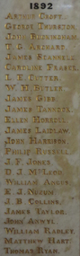 Old Colonists' Association of Ballarat Inc.
Photograph - Photograph - Colour, Marble Honour Boards listing benefactors to the Ballarat Old Colonists' Associations
The Old Colonists' Hall opened in 1887.Marble Honour Boards listing benefactors to the Ballarat Old Colonists' Associations. The name was added to the boards the year of the donors death. 1892 Arthur Croft George Thurston John Buckingham T.G. Archard James Scannele Caroline Fraser L.E. Cutter W.H. Butler James Gibb James Tannock Ellen Horroll James Laidlaw John Harrison Philip Russell J.F Jones D.J. McLeod William Angus E.J. Nuzum J.B. Collins James Taylor John Anwyl William Radley Matthew Hart Thomas Ryan 1897 William Taylor Joseph Langfon W.C. Phillips Henry Dobson Peter Brose Edwin Parr John Magor Natale D'Angri Lawson Ure James Malcolm Robert Sim W.J. Clarke F.N. Martin William Kelly Edward Hrose Francis Edwards William Kay James Simpson J.R. Hopkins W. Booth 1898 John Peart J.J. Cahir Joseph Betts Thomas Rowlands George Brown Rudolph Stephens James Houston John McPhee Alban Atwood David Fitzpatrick L.H. Kopke Henry Morrison William Bones Henry Morris 1899 Alexander Miller David McNaught C.W. Langtree John Twentyman Nathaniel Trench Adam Bennett James Gay C.B. Retallack James Richardson Thomas Hawkins John Taylor D.F. Stalker William Laplau John Jarvie J.E. Morris James Harrison J.S. Paterson Henry Leggo W.J. Seeley Charles Stewart James Vigar J.J. Cahir Joseph Betts Thomas Rowlands George Brown Rudolph Stephens James Houston John McPhee Alban Atwood David Fitzpatrick L.H. Kopke Henry Morrison William Bones Henry Morris 1900 Peter Le Page W.H. Barnard George Perry George Eason James Ivey 1903 James Miller Matthew Morgan William Norman G.G. Graham John Griffiths Richard Ince John Wallace John Blight J.W. Mills C.E. Jones John Noble Wilson David Mitchell William Walner David Munroe John English David McDonald William Saunders William Dougall A.T. Morrison Thomas Wilson M.C. Donnelly James Fry John Haworth Edward Newman E.F. McElroy J.H. Reed Helen Trounson E.A. Miller Alexander Ross Alexander Taylor H.A. Comber 1909 John Blyth Charles Tunbridge Henry Gore Walter Owen Charles Rowsell Edward Elliott Charles Robinson T.J. Wills R.S. Hager Henry Fields T. Paterson William Woodridge A. Morrah Adam Scott J.C. Shepherd J. Holland J. Cochran G. Lovitt J. Haig G. Sharp J. Dulfer R. Davidson E. Lillingston T. Raw 1911 W.H. Uren John Paterson H.J. Summerscales James Oddie W.H. Malyon T.E. Gill Agnes D. McIntosh John Wright Andrew Byrne Thomas Greenwood H.W. Morrow James Lambert E.E. Eberhard John Reid T.W. Purdue H.J. Symons John Lynch 1915 William Bell D.B. Wheeler Richard Baker M.L.C. W.B. Bradshaw Betsy F. Graham A.J. Hare C.V. Day J.P. Smart Lieutenant Colonel A.H. White Dr R.C. Lindsay Andrew Cant T.C. Coates E. Goodwin Thomas Lyle 1916 James Long John King Junior G.A. Brown C.E. House G.T. Jones Hon. R.T. Vale J.G. Tucker H. Baber J. Lammin D. Lillingstone George Becher Laurence Clark William Brazenor A. Clinton William Little W.B. Bannerman J.H Peady James Lamb 1917 J.C. Charles Joseph Fields John McPhail John Lombard Thomas Lyle H.L. Pobjoy E.E. Llewellyn E.C. Dermer John M. Bickett Hon. J.Y. McDonald Capt. J.W. Pearce. M.C. Joseph Pounder 1918 Lieutenant E.S. Holgate Grace Valkins J.C. Brough Thomas Mitchell George Buchanan J.H. Ward T. Davey A.B. Berry Corporal L.J. Malin G.H. Abrams James Tyler 1919 T.C. Anderson Agnes Murray G. Donaghy F. Opie Thomas Bodycomb Harry D. Davies John Clarke R.L. Medwell G.N. Robinson Isaiah Pearce A.R. Tunbridge H.C. Handford F.G. Fraser F. Carver J.S. Douglas Hon. Alfred Deakin T.J. McConnellarthur croft, george thurston, john buckingham, t.g. archard, james scannele, caroline fraser, l.e. cutter, w.h. butler, james gibb, james tannock, ellen horroll, james laidlaw, john harrison, philip russell, j.f jones, d.j. mcleod, william angus, e.j. nuzum, j.b. collins, james taylor, john anwyl, william radley, matthew hart, thomas ryan, william taylor, joseph langfon, w.c. phillips, henry dobson, peter brose, edwin parr, john magor, natale d'angri, lawson ure, james malcolm, robert sim, w.j. clarke, f.n. martin, william kelly, edward hrose, francis edwards, william kay, james simpson, j.r. hopkins, w. booth, john peart, j.j. cahir, joseph betts, thomas rowlands, george brown, rudolph stephens, james houston, john mcphee, alban atwood, david fitzpatrick, l.h. kopke, henry morrison, william bones, henry morris, alexander miller, david mcnaught, c.w. langtree, john twentyman, nathaniel trench, adam bennett, james gay, c.b. retallack, james richardson, thomas hawkins, john taylor, d.f. stalker, william laplau, john jarvie, j.e. morris, james harrison, j.s. paterson, henry leggo, w.j. seeley, charles stewart, james vigar, j.j. cahir, joseph betts, thomas rowlands, george brown, rudolph stephens, james houston, john mcphee, alban atwood, david fitzpatrick, l.h. kopke, henry morrison, william bones, henry morris, 1900, peter le page, w.h. barnard, george perry, george eason, james ivey, james miller, matthew morgan, william norman, g.g. graham, john griffiths, richard ince, john wallace, john blight, j.w. mills, c.e. jones, john noble wilson, david mitchell, william walner, david munroe, john english, david mcdonald, william saunders, william dougall, a.t. morrison, thomas wilson, m.c. donnelly, james fry, john haworth, edward newman, e.f. mcelroy, j.h. reed, helen trounson, e.a. miller, alexander ross, alexander taylor, h.a. comber, john blyth, charles tunbridge, henry gore, walter owen, charles rowsell, edward elliott, charles robinson, t.j. wills, r.s. hager, henry fields, t. paterson, william woodridge, a. morrah, adam scott, j.c. shepherd, j. holland, j. cochran, g. lovitt, j. haig, g. sharp, j. dulfer, r. davidson, e. lillingston, t. raw, w.h. uren, john paterson, h.j. summerscales, james oddie, w.h. malyon, t.e. gill, agnes d. mcintosh, john wright, andrew byrne, thomas greenwood, h.w. morrow, james lambert, e.e. eberhard, john reid, t.w. purdue, h.j. symons, john lynch, william bell, d.b. wheeler, richard baker m.l.c., w.b. bradshaw, betsy f. graham, a.j. hare, c.v. day, j.p. smart, lieutenant colonel a.h. white, dr r.c. lindsay, andrew cant, t.c. coates, e. goodwin, thomas lyle, james long, john king junior, g.a. brown, c.e. house, g.t. jones, hon. r.t. vale, j.g. tucker, h. baber, j. lammin, d. lillingstone, george becher, laurence clark, william brazenor, a. clinton, william little, w.b. bannerman, j.h peady, james lamb, 1917, j.c. charles, joseph fields, john mcphail, john lombard, thomas lyle, h.l. pobjoy, e.e. llewellyn, e.c. dermer, john m. bickett, hon. j.y. mcdonald, capt. j.w. pearce. m.c., joseph pounder, lieutenant e.s. holgate, grace valkins, j.c. brough, thomas mitchell, george buchanan, j.h. ward, t. davey, a.b. berry, corporal l.j. malin, g.h. abrams, james tyler, t.c. anderson, agnes murray, g. donaghy, f. opie, thomas bodycomb, harry d. davies, john clarke, r.l. medwell, g.n. robinson, isaiah pearce, a.r. tunbridge, h.c. handford, f.g. fraser, f. carver, j.s. douglas, hon. alfred deakin, t.j. mcconnell -
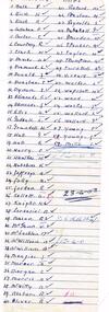 Ballarat Tramway Museum
Document - List, Dave Kellett, "Welfare Club Payment", 23/04/1953 12:00:00 AM
Yields information about the SEC Ballarat tram employees names for 23/4/ 1953. Has a strong association with the list Author. Also demonstrates the administration of a locally based welfare fund.Carbon copy of a hand written list dated 23-4-1953 of 59 people on the front and two on the rear showing payment to the Ballarat Tramway "Welfare Club Payment". Payment appears to total 12 pounds 4 shillings. See also Reg item 6312 for a June 1952 list. Handwritten on ruled paper which has been folded into four. Note: - this list may also include depot employees. List compiled from the .xls file compiled by Peter Waugh. The ones listed as record 6312 only below. Bath Percy Carl Motorman 1949 1971 6312 Birch Harold Reginald Conductor 1949 1963 6312 Black E. 1953 6312 Carter T. 1953 6312 Courtney R. 1953 6312 Davies A. 1953 6312 Diamond Leo Motorman 1953 1954 6312 Donald James Frederick 1949 1963 6312 Dynon J. 1953 6312 Ellis Alfred Lewis Motorman 1942 1968 6312 Hall Keith William Conductor 1953 1954 6312 Harry D. 1953 6312 Hutchins K. 1953 6312 Jolly A. 1953 6312 Jordan R. 1953 6312 Kellett Alfred Joseph Tramway employee 1949 1971 6312 McGann N. 1953 6312 Menzies J. 1953 6312 Mills I. 1953 6312 Morgan Colin George 1953 1963 6312 Morris N. 1953 6312 Oliver R. 1953 6312 Pinkard M. 1953 6312 Spencer M. 1953 6312 Taylor H. 1953 6312 Thompson Arthur Frederick Mark 1953 1954 6312 Vicars A. 1953 6312 Wapshott Herbert William 1953 1954 6312 Weeks John Herbert Motorman 1953 1954 6312 Wellard Graham Charles 1953 1954 6312 Young S. 1953 6312 These people have more than one entry into the data base T. Dunstan H. Grundell G. Hall H. Hawkes A. Jeffreys D. Kellett H. Knight H. Lorensini H. McWilliams A. McWilliams R. Mason A. Mercer R. Nestor H. Preston S. Reynolds H. Smerdon G. Satchell R. Turnbull A. Vicars W. Ward L. Walker L. Wellard S. Young T, Young J. Menzies F. Edmonds S. Edmonds F. Callahan N. Clark L. Godsell N. McLachlan F. Brown J. Myers On rear "Welfare Club Payment"sec, ballarat, personnel, welfare, crews -
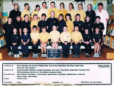 Bendigo Historical Society Inc.
Photograph - GOLDEN SQUARE MAPLE STREET P.S. COLLECTION: PHOTOGRAPH - GRADE 5-6 S 1999
Golden Square Maple Street P.S. Collection - Photograph - Grade 5-6 S 1999 class and their teacher. Their names are: 3rd Row L-R: Reece Alderding, Tim Marmion, Felicity Usher, Tracey Priest, Dylan Hunt, Erin Wyatt, Jessie Taylor, Max Grant, Amy Campbell. 2nd Row L-R: Jacquie Fordham, Michele Brannagan, Sam Bacon, Kate Geyer, Toby Martin, Jessica Hall, Llewellyn Green, Miriam Henderson, Kyle Bevans, Tara Sullivan, Broderick Gordes. Front Row L-R: Hope Williams, Chas Barker, Lindon Stewart, Martin Olsen, Lisa Haines, Nicholas Parker, James Ng, Rebecca Negus, Jessie Rodgers. Absent: Clinton Turner. Teacher: B Savy. Principal: Mr David Robins.Arthur Reed Photoseducation, primary, golden square laurel st p.s., golden square maple street p.s. collection - photograph - grade 5-6 s 1999, reece alderding, tim marmion, felicity usher, tracey priest, dylan hunt, erin wyatt, jessie taylor, max grant, amy campbell, jacquie fordham, michele brannagan, sam bacon, kate geyer, toby martin, jessica hall, llewellyn green, miriam henderson, kyle bevans, tara sullivan, broderick gordes, hope williams, chas barker, lindon stewart, martin olsen, lisa haines, nicholas parker, james ng, rebecca negus, jessie rodgers, clinton turner, b savy, mr david robins, arthur reed photos -
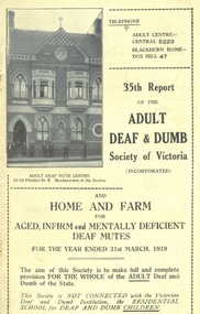 Expression Australia
Annual Report, 35th Report of the Adult Deaf and Dumb Society of Victoria 1919
The Adult Deaf and Dumb Society of Victoria, now known as Vicdeaf, (the Victorian Deaf Society), was founded in 1884 as the Victorian Society for Promoting the Spiritual and Temporal Welfare of the Adult Deaf and Dumb. The provisional committee being Mr W Bates, Mr J M Bruce, Mr J D Gowan, Mr Edwin Newbiggin, Mr C M Officer, M. L, A., and the Rev. W. Moss. The Adult Deaf and Dumb Mission's objects were: 1. To provide the means for religious worship and instruction for the adult deaf and dumb of Victoria 2. To visit the deaf and dumb in their homes, especially when sick or in distress 3. To assist the deaf and dumb of good character in obtaining suitable employment 4. To provide technical and other education for the adult and dumb 5. To give pecuniary assistance to adult deaf and dumb who are in needThe Annual Reports of the Adult Deaf and Dumb Society are historically significant providing insight into the history of the evolving Deaf Community in Victoria. They are a annual 'snapshot' of the year with references not only to the progress of the Society but also to the significant people and events within the Deaf Community.Cream Cover, Size 21.5Hx13.5W, 56 pagesarthur stanley, w. g. mcbeath, e. r. peacock, r. j. oehr, h. l. walters, m. l. miller, john higgins, g. g. mercy, harold w. bickford, george brown, a. macaulay caldwell, w. a. dickins, f. e. frewin, j. m. johnston, r. h. luff, h. sumner martin, george vial, ernest j. d. abraham, r. dow, e. empson, l. fletcher, d, hickey, a. graham, mrs c. robertson, e. r. smith, mrs a. wilso, mab dow, ivy cole, j. craig, john cronin, alex williamson, adam c. muir, w. taylor, s. moss, m. g. b mortimer, blackburn, deaf workers club, ramblers club, j. johnston, m. maloney, lacrosse, cricket, t. a. nelson, a suthersland, w. a. paterson, n. amos, j. leber, j. cariss, alfred peacock, mrs abraham, g. rees, s. w. showell, w. warren, isabella fister, nora kennedy, -
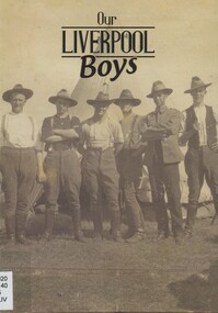 Surrey Hills Historical Society Collection
Book, Our Liverpool Boys, 2015
Sent to the collection as part of the Centenary of the ANZAC Gallipoli landing, 2015. This publication reveals the stories of everyday civilians-turned-soldiers who served in the trenches and on the front lines, highlighting their vast contribution to the war effort, including those who made the ultimate sacrifice.This publication reveals the stories of everyday civilians-turned-soldiers who served in the trenches and on the front lines, highlighting their vast contribution to the war effort, including those who made the ultimate sacrifice.world war, 1914-1918, miltary history, (mr) cecil alfred ashcroft, (mr) arthur percival attwood, (mr) thomas walter barker, (mr) george francis bell, (mr) lawrence robert hanna, (mr) charles elvin hyland, (mr) john frederick kammel, (mr) joseph harold kemp, (mr) harry boyland, (mr) james ashcroft braithwaite, (mr) walter henry brewster, (mr) william brown, (mr) charles alfred bull, (mr) william francis cloke, (mr) eric gladstone deadman, (mr) george leslie fullagar, (mr) joseph gomes, (mr) eric sydney walpole sealy-vidal, (mr) samuel kirkpatrick, (mr) nathan douglas lackie, (mr) joseph henry leach, (mr) harry learoyd, (mr) charles m mcfarline, (mr) joseph campbell mcmiles, (mr) robert mcmiles, (mr) james unison morn, (mr) edward hugh oprey, (mr) arthur salis, (mr) (henry) studley sealy-vidal, (mr) walter samuel shaw, (mr) walter samuels, (mr) samuel john southwell, (mr) geoffrey gordon steenson, (mr) eric andrew taylor, (mr) alfred charles thorn, (mr) andrew charles thorne, (mr) campbell throsby, (mr) william george waters, (mr) albert ernest wearne, (mr) thomas william garnet whitney, liverpool training camp, holsworthy internment camp -
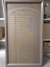 Vision Australia
Photograph - Image, Tilly Aston award 15 years of service boards
The Tilly Aston Award was presented for 15 years of service. This signboard commemorates recipients of the this award and was displayed at the Kooyong centre until it's refurbishment. The list of names is as follows: 1987 Betty Dainton, 1990 Beryl Smout, 1990 Vi Wilkinson, May Wallace, 1991 Bill Arthur, 1992 Peg Lucas, 1993 Nell Gibbons, Ilma Jewell, Charles Parker, 1994 Margaret Collins, Coral Matheson, 1997 Louise Doddrell, Alma Davey, Janice Cowan, Elaine Coe, Peg O'Dea, 1998 Mary Burgess, Val Doyle, May Edwards, Margaret Ford, Mais Opie, Moira Proustie, Dorothy Shipston, Moira Spencer. (Second board:) 1998 Yvonne Taylor, Vera Watkins, Elaine McMullan, 1999 Gwen Dick, Ron Matheson, Penny Ford, Joyce Oxenbury, 2000 Jean Hocking, Nilma Henson, Eileen Burke, 2001 Lorna Britton, 2002 Joan Feldtman, Elwyn Gayfer, Beryl Alexander.Boards with grey wash and vinyl gold letteringTilly Aston Award 15 years Service (thereafter follows a list of names that extends across to a second board)association for the blind, volunteers, nameplates -
 Vision Australia
Newspaper - Image, Lady Nell Seeing Eye Dog School newspaper cuttings 1969-1978, 1969-1978
Newspaper articles about blindness, visually impaired or blind people and activities.Scanned copies of newspaper articles collected by Lady Nelllady nell seeing eye dog school, royal victorian institute for the blind, association for the blind, royal institute for the blind (sa), villa maria society, queensland industrial institute for the blind, guide dogs for the blind association of victoria, australian national council of and for the blind, phyllis gration, max medlyn, christopher finnen, dawn goebel, arthur mackey, walter jacobs, kevin o'mahoney, jean smith, pam marks, white cane, assistive devices, garry stinchcombe, matey fisher, robert gordon, ruth keoden, winsome mclean, arthur wilkins, len childs, bob elliott, graham miller, jack birkett, norman pressey, don westaway, norman salmon, mark houran, yvonne simpson, irmo guglielamana, jenny ziviani, shaun oliver, peter goss, albert poelstra, ewan gouldon, uncle ben's of australia, dr henry nowik, mary martin, kathleen wenzer, donna hayes, ken campbell, barry murphy, michael riley, jack dowdle, harold gration, leah francis (nee wilson), john dingle, alex mcnish, peter richards, irene mye, jim finn, cec mcillwraith, terry carlson, keith smith, gordon stent, frank taylor, don verlander, olive moody, roslyn sackley, ross johnson, jako mikulic, jewel blanche, william mckennariey, vicki barclay, grantley dee, ray hannah -
 The Beechworth Burke Museum Research Collection
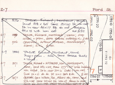
Card (Series) - Index Card, George Tibbits, Ford Street, Beechworth, 1976
George Tibbits, University of Melbourne. Faculty of Architecture, Building and Town & Regional PlanningIndex system that support the research for Beechworth : historical reconstruction / [by] George Tibbits ... [et al]Arranged by street names of BeechworthEach index card includes: street name and number of property, image of property, allotment and section number, property owners and dates of ownership, description of the property according to rate records, property floor plan with dimensions.beechworth, george tibbitsbeechworth, george tibbits -
 Melton City Libraries
Photograph, Melton Urban Fire Brigade, 1970
C.E Barrie was the Urban brigade's first captain. November 19, 1975, Page 2 OBITUARY Ex-Captain C E BARRIE Over 50 firemen attended the funeral of Ex- Captain Edgar Barrie of Melton Fire Brigade who died at the age of 62 on Thursday 16th October, 1975. Edgar was a volunteer fireman for 33 years, all of this service with the Melton Rural and Urban Fire Brigades. He joined the rural brigade in February 1942 was Secretary 1942 until 1965 when he became Captain as position he held until 1973. He was the urban brigade’s first Captain when it was formed in 1970 and held this position until 1971. The fire service runs in the Barrie family, brother Bon was Captain of the rural brigade from 1953 to 1965 relinquishing the position to become Group Officer of the Mt Cottrell Group, a position he still holds. Another brother Tom has been a member since 1941, nephew Peter has been a member since 1962 and Edgar’s son Vivian has been a member since 1971. Firemen, led by Snr. A/C/O Max Taylor, A/C/O Harry Rothsay, R/O Arthur Haynes and retired R/O Jim Dinsdale formed a guard of honour at the church and cemetery. A/C/O Rothsay read the Fireman’s Funeral Ritual at the graveside. Edgar who was a farmer, leaves a wife and four children. Sympathy is extended to them in their loss. Six members from the Melton Urban Brigade including Captain C.E Barrie, Secretary Dale Blampied, Lieutenant Steve Hirt, Apparatus Officer Graham Quick and Foreman Barry Sherwell.local identities, emergency services