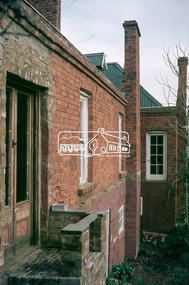
Showing 438 items matching " brick home"
-
 Eltham District Historical Society Inc
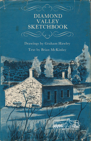
Book, Diamond Valley sketchbook / text by Brian McKinlay ; drawings by Graham Hawley, 1973
... Hotel, Heidelberg, Eltham Primary School, Mud brick homes... Hotel, Heidelberg, Eltham Primary School, Mud brick homes ...Contents include short articles and illustrations of historic properties within the municipalities of Banyule, Nillumbik and Whittlesea. Including The Griffin House, Rosehill, Lower Plenty, The Austin Hospital, Heidelberg, St John's Church, Heidelberg, Banyule, Heidelberg, Trestle Bridge, Eltham, Diamond Valley railway, The Shillinglaw Cottage, Eltham, Montsalvat, Old England Hotel, Heidelberg, Eltham Primary School, Mud brick homes, Eltham, Sweeney's Cottage, Eltham, Pound Pend Tunnel, The Gold Memorial, Potter's Cottage, Memorial Tower, Charterisville, Weller's Pub, The Barrel, Eltham, Hassall's Gallery, The Old Bridge, Greensborough, Diamond Valley Shire Offices, Greensborough, St Katherine's Chapel, Yan Yean Reservoir, Mernda Hotel, Mernda Mechanics Institute, Old Barn, Mernda, Parade College, La Trobe University.Hardback with jacket ; 63 p. : ill., maps ; 22cm. diamond valley shire, shire of nillumbik, city of whittlesea, city of banyule, shillinglaw cottage, weller's hotel -
 Kew Historical Society Inc
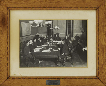
Photograph - Framed Photograph, Kew Town Council, circa 1903, c. 1904
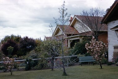
... his two-storey red brick home, on the ‘corner of Gellibrand... his two-storey red brick home, on the ‘corner of Gellibrand ...Medical practitioner Sir Stanley Seymour Argyle (1867-1940) was a man ‘much admired’ for his civic contribution to Kew. To ensure ‘pure [uncontaminated]’ milk for Kew, he co-foundered the Willsmere Certified Milk Company in 1898. His mayoralty of Kew, 1902-04, exhibited superior leadership. In association with local chartable institutions and churches he ensured the unemployed of Kew were not distressed. He also agitated for the removal of the Kew Lunatic Asylum. After a long stint as a doctor in the Army Medical Corps with the Australian Expeditionary Force, Kew formally welcomed him back home in 1918. However, in 1919 he left his two-storey red brick home, on the ‘corner of Gellibrand Street’ for Toorak. He went on to have an outstanding career in radiology at the Alfred Hospital and in Victorian politics. He was cremated following a State funeral. (SMcW)An important photograph of local and statewide historical significance showing Sir Stanley Argyle, Mayor of Kew. Argyle was later to be Premier of Victoria. This is a commemorative photograph, presented by Argyle to the Town of Kew.An early, important photograph of the Kew Councillors at a meeting in the Council Chamber of the Kew Town Hall in Walpole Street. The framed photograph was donated by Sir Stanley Seymour Argyle (1867-1940) who was Mayor of Kew in 1902-03 and 1903-04. Stanley Argyle, later to be Premier of Victoria, is in the mayoral chair wearing his robes of office. The photograph was once displayed in the Kew Town Hall. Brass Plaque: "Presented by / Cr Stanley S. Argyle / Mayor 1902-3 & 1903-4".sir stanley argyle (1867-1940), kew town council, council chamber (kew town hall) -
 Royal District Nursing Service (now known as Bolton Clarke)
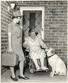
Photograph - Photograph, black and white, 1967
... on the veranda of Mrs. Lata's brick home, and is smiling as she observes... is standing on the veranda of Mrs. Lata's brick home, and is smiling ...Royal District Nursing Service (RDNS), Sister Meisser is visiting Mrs. Lata to attend to the nursing care she requires in her home. She is greeting Mrs. Lata on her veranda and is observing her interaction with her dog. Sr. Meisser is wearing her RDNS uniform of a grey cotton short sleeve frock with a small white arched material logo with 'Royal District Nursing Service' in blue capital letters emblazoned on it, attached to the upper sleeve. She is wearing her grey peaked hat. This had a metal RDNS logo attached to the centre front. Sister Meisser worked from the RDNS Moorabbin centre.From its earliest years when the Trained nurses of the Melbourne District Nursing Society (MDNS) began to wear uniforms, the chosen colour was grey, though the style changed throughout the years as fashions changed from the late 1800s through to the 1970s. Their Trained nurses (Nurses) firstly wore long grey frocks and a white cap with a long white tail hanging from the centre back. When bicycles were introduced the headgear changed to a white pith helmet adorned with a red Maltese cross in the centre front. This was held on with a veil going over the hat and tied under the chin. Over the years there were complaints that the veils became wet in the rain and they asked for a change of uniform, but this did not happen until 1921. Later the Nurses complained their skirts became wet when riding their bicycles in the rain and asked, when raining, to be able to wear breeches and gaiters. This was granted provided they wore aprons when attending patients. It was not long before the uniform changed to a shorter length grey frock, red cardigan, grey coat and grey brimmed hat; later changed to a peaked grey hat. This uniform was used when MDNS was granted Royal patronage in 1966 and worn until 1971 when the uniform changed to a blue V necked frock over a short sleeve white blouse in summer and a blue/grey skivvie under a blue/grey herringbone V neck tunic style frock made of winter material in the cooler weather. Black and white photograph of Royal District Nursing Service (RDNS), Sister Meisser, of Moorabbin Centre. She is standing on the left of the photograph; has short dark hair and is wearing her grey uniform with peaked hat and black shoes, and is holding her rectangular nursing case. She is standing on the veranda of Mrs. Lata's brick home, and is smiling as she observes, to her right, Mrs. Lata, who has grey curly hair and is wearing a light coloured floral frock. Mrs. Lata is sitting in her wheelchair and with her left hand is patting her pale coloured Labrador dog who has a dark collar and is sitting to her right. Mrs. Lata is in front of her security door which has a white door frame. The house has a white lantern shaped light attached to the wall on the left hand side of the photographPhotographer's stamp and the word 'Publicity'royal district nursing service, rdns, rdns uniform, moorabbin centre, mrs lata, sister m. meisser -
 Mt Dandenong & District Historical Society Inc.
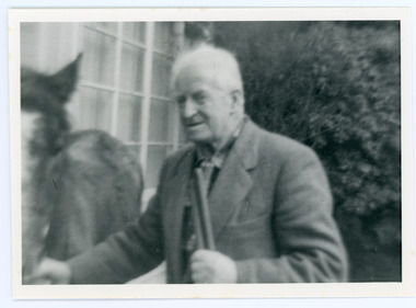
Photograph, Edward John Price 1973
... . They lived in the first brick home built in the district. They had... John married Myra Wilson in 1930. They lived in the first brick ...John Lundy-Clarke grew up in the Kalorama/Mt Dandenong area and later in life (1972-74) began to write a comprehensive history of the district working from an original settlement map in an effort to cover all areas. Edward John Price (Ted)(1899-1974) was the third child of Edward Joseph and Annie Price. He lived a very industrious life in the area. When the new CRB road cut through the family land Edward John established a Corn and Produce store on a level area adjoining the new road . Along with his brother Charlie, Ted took up road contracting and formed Grange Road in 1923. They also took up contracts to metal the CRB road between The Gap and Olinda. Edward John married Myra Wilson in 1930. They lived in the first brick home built in the district. They had two sons, Edward Joseph 2nd and Alan.Black and white photograph showing an old man dressed in a jacket holding the reins of a horse. Reverse of photograph has handwritten description by John Lundy-Clarke.Edward John Price 1973. Son of Edward Joseph & Annie Ada nee Ross. Born 1899 died 1974. Farmer, Carrier, Sawmiller, Contractor, Quarry Owner, Shop Proprietor (Kew Junction 1935). Father of Alan & Edward J.edward john price, myra wilson, edward joseph price, annie price, alan price, charles price, grange road, crb road -
 Phillip Island and District Historical Society Inc.
Photograph, 1927
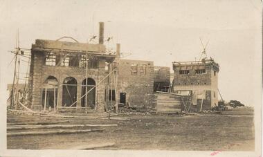
... Home, the bricks were in place. Photo showing the arches... of the building of St Pauls Home, the bricks were in place. Photo showing ...A photograph of the progress of the building of St Pauls Home, the bricks were in place. Photo showing the arches of the 2 storey brick construction.Building progressed to the brick construction. Sepia photograph of the 2 storey building. Photo showing the arches of the 2 storey brick construction with scaffolding and building supplies.local history, photography, photographs, slides, film, st pauls training school, schools, phillip island, sepia photograph, ken pound -
 Surrey Hills Historical Society Collection
Photograph, 6a Thistle Street, Surrey Hills, 1924
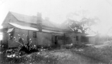
... Black and white photo of a timber home with brick chimneys... street Black and white photo of a timber home with brick chimneys ...One of the oldest homes in Surrey Hills. The photo was taken in 1924 when the property was purchased by Mr John Francis Evans, father of Mrs Lillian Austin. The Evans family came from Gembrook. John Evans was born in Wales; he and his wife Mary had 3 children, 2 daughters and one son. Mary Evans pre-deceased her husband, who died on 23 October 1924 at Hillsborough, 6A Thistle Street. The first owner of the property was Mrs Rachel Sweetnam (nee Lewis) who married Thomas Edward Sweetnam on 24 September 1884 at St John's Church, Camberwell. REF: THE ARGUS 4 Oct 1884 Thomas second eldest surviving son of Matthew Sweetnam married to Rachel (Ray) third eldest daughter of Captain T.D. Lewis, Culm Haven, Camberwell. Thomas was active in land sales and variously described as a land agent, real estate agent and auctioneer. The property - Hillsboro or Hillsborough - was originally a house on a farm of 10 acres owned by her. It became 6A Thistle Street. According to the Alan Holt property register Rachel Sweetnam owned the property prior to 1890 and a family tree on Ancestry.com has that it was owned by her in c1886. It is likely that at this stage the property was an investment rather than the Sweetnam's family residence. Other property owners or residents are: 1890 Selina Gaylor 1900 Stephen Pullen 1910 William Murray (draftsman) 1920 George C Hughes 1930 Arthur Leslie Austin (tram driver) 1980 Mrs Lillian Evelyn Austin Lillian Austin died on 19 August 1983 and the property was sold that year for $87,000. The house is still extant (January 2025). Note that we also have material / photos regarding George Hughes and family.Black and white photo of a timber home with brick chimneys and a (?) corrugated iron roof. There are sheds and outbuildings attached to the house. The garden looks untended. In the background a mature eucalypt tree can be seen.houses, hillsboro, timber houses, mrs lillian austin, hillsborough, selina gaylor, stephen pullen, william murray, george hughes, arthur austin, john francis evans, thistle street -
 Eltham District Historical Society Inc
Magazine - Magazine Article, Rosscorp Pty Ltd, 1990 Home Directory Magazine, 1990
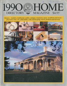
... by Gordon Ford • “At Home with the Browns”, pp114-116 ‘Cherrytrees... by Gordon Ford • “At Home with the Browns”, pp114-116 ‘Cherrytrees ...Articles featuring local Eltham mudbrick houses designed by Robert Marshall, Alistair Knox, etc and landscape bush gardens by Gordon Ford • “At Home with the Browns”, pp114-116 ‘Cherrytrees’, home of Margaret and Neil Brown, originally built in 1917 for eminent Collins Street surgeon, Dr. Kent-Hughes. • “The Mud Brick homes of Eltham”, pp148-149 References to Alistair Knox and Robert Marshall • “Mudbrick Collecting”, pp150-155 Features a Robert Marshall designed home built by Barry Wild and Geoff Williams • “Mudbrick sophistication”, pp156-158 Features a Robert Marshall designed home with Gordon Ford landscape garden • “It grew like topsy”, pp160-162 originally designed by Alistair Knox then extended upon • “A love of the environment”, pp163-164 Features artist and local Councillor Jenni Mitchell’s mudbrick cottage designed by Bohdan (Danny) Kuzyk with influences of Alistair Knox • “Build your own muddy”. Pp165-167 • “Pioneer of bush gardens; Gordon Ford and his no mowing no weeding approach”, pp174-177 robert marshall, alistair knox, gordon ford, mudbrick, margaret brown, neil brown, cherrytrees, dr kent-hughes, eltham, barry wild, geoff williams, jenni mitchell, bohdan (danny) kuzyk, bush gardens -
 Eltham District Historical Society Inc
Slide, "Kangaroo Hall" (c.1843-1969), Donaldsons Road, Kangaroo Ground, which was destroyed during the January 8, 1969 bushfire; c.1975, 1975c
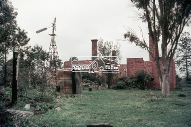
... by this substantial brick home around the mid 1840s. James Donladson died 1856... by this substantial brick home around the mid 1840s. James Donladson died 1856 ...Built by James and Isabella Donaldson at the centre of their 1 square mile property southwest of the present day Presbyterian Church. The Donaldsons first arrived in Port Phillip on 17 December 1841. Their first house was a bark hut which was replaced by this substantial brick home around the mid 1840s. James Donladson died 1856. Kangaroo Ground Presbyterian Church http://kgpc.pcvic.org.au/history-2.html Pictures of the farm and homestead (rented by Mr E. Hobson) were published in The Weekly Times, 18 March 1911, p27 1911 'MR. E. HOBSON'S FARM AT KANGAROO GROUND.', Weekly Times (Melbourne, Vic. : 1869 - 1954), 18 March, p. 27. , viewed 29 Feb 2020, http://nla.gov.au/nla.news-article222243528 A letter from Mr Hobson published in the following edition clarified that he only rented the property and that the owner was Mr John Donaldson of Sandringham 1911 'KANGAROO GROUND.', Weekly Times (Melbourne, Vic. : 1869 - 1954), 25 March, p. 47. , viewed 29 Feb 2020, http://nla.gov.au/nla.news-article22224117935 mm colour positive transparency Mount - Agfacolor Service (Blue)bushfire, donaldson home, donaldsons road, isabella donaldson, james donaldson, kangaroo ground, kangaroo hall, victorian bushfires - 1969 -
 Eltham District Historical Society Inc
Slide, "Kangaroo Hall" (c.1843-1969), Donaldsons Road, Kangaroo Ground, which was destroyed during the January 8, 1969 bushfire; c.1975, 1975c
... by this substantial brick home around the mid 1840s. James Donladson died 1856... by this substantial brick home around the mid 1840s. James Donladson died 1856 ...Built by James and Isabella Donaldson at the centre of their 1 square mile property southwest of the present day Presbyterian Church. The Donaldsons first arrived in Port Phillip on 17 December 1841. Their first house was a bark hut which was replaced by this substantial brick home around the mid 1840s. James Donladson died 1856. Kangaroo Ground Presbyterian Church http://kgpc.pcvic.org.au/history-2.html Pictures of the farm and homestead (rented by Mr E. Hobson) were published in The Weekly Times, 18 March 1911, p27 1911 'MR. E. HOBSON'S FARM AT KANGAROO GROUND.', Weekly Times (Melbourne, Vic. : 1869 - 1954), 18 March, p. 27. , viewed 29 Feb 2020, http://nla.gov.au/nla.news-article222243528 A letter from Mr Hobson published in the following edition clarified that he only rented the property and that the owner was Mr John Donaldson of Sandringham 1911 'KANGAROO GROUND.', Weekly Times (Melbourne, Vic. : 1869 - 1954), 25 March, p. 47. , viewed 29 Feb 2020, http://nla.gov.au/nla.news-article22224117935 mm colour positive transparency Mount - Agfacolor Service (Blue)bushfire, donaldson home, donaldsons road, isabella donaldson, james donaldson, kangaroo ground, kangaroo hall, victorian bushfires - 1969 -
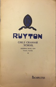 Kew Historical Society Inc
Document, Ruyton Girl's School, Ruyton Girls' Grammar School, Prospectus, 1950
... , but once known as ‘Tarring’. The grand, polychrome brick home..., but once known as ‘Tarring’. The grand, polychrome brick home ...Ruyton was founded in 1878 in the Bulleen Road, Kew, home of newly widowed Mrs Charlotte Anderson (now High Street South). There she hired a governess, Miss Flora Barton, to educate a small group of children, including her own, in her front parlour. Her school immediately flourished. By 1882 she was able to move it to larger premises at ‘Edgecomb’, in Studley Park Road, and name it Ruyton, after a family connection with the village of Ruyton-XI-Towns, Shropshire, England. Since that time Ruyton has continued to thrive, outgrowing its Edgecomb site, and another at A’Beckett Street, Kew, before settling into its current home in Selbourne Road in 1920. The centrepiece of this property is Henty House, now named for its original owners, Henry and Marion Henty, but once known as ‘Tarring’. The grand, polychrome brick home was built in 1872 and with nearly four acres of gardens and grounds around it, it has proved to be a place where Ruyton and its students could continue to prosper. (source: Ruyton website 2020)Prospectus provided in response to an enrolment inquiry in 1950 for Ruyton Girls' Grammar School. (See also Item 2016.0468)ruyton girls grammar school -
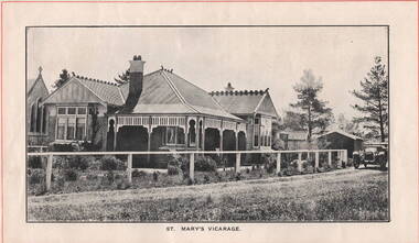 Sunbury Family History and Heritage Society Inc.
Photograph, ST. MARY'S VICARAGE, c1920
... border across the top and base of the image off a brick... border across the top and base of the image off a brick ...The Federation style house was the former vicarage for St. Mary's Church in O' Shanassy Street, Sunbury. It replaced the former 'Priorswood' vicarage, which was in Station Street about a mile from the church. The foundation stone for the new vicarage was laid by Mrs. Russell Clarke on 21st February 1914 and was opened by His Grace the Archbishop of Melbourne on 10th June 1914. A non-digital black and white photograph with a cream border across the top and base of the image off a brick federation style home with a corrugated iron roof. It has a return verandah with a decorative wooden trip under the eaves. A car is parked in the street by the gate and there are two buildings behind the house.st. mary's church of england, sunbury, vicarages, o'shanassy street -
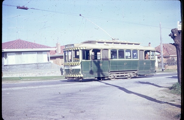 Ballarat Tramway Museum
Photograph - Digital image, Joy Waller, 19/09/1971 12:00:00 AM
... in the background. Three brick veneer homes can be seen. The photographer... leaning on a fence in the background. Three brick veneer homes can ...Copy of a colour slide showing Tram 17 in Lydiard Street North, at the terminus. From the direction of the trolley pole and the sign on the destination board, it is preparing to return to Sebastopol. One of the crew can be seen leaning on a fence in the background. Three brick veneer homes can be seen. The photographer says this was taken on the last day of trams in Lydiard Street in 1971. (More likely 17/9/1991 based on A Cook notes, 17 was not used on the last day, all bogie trams)trams, tramways, ballarat trams, crews, houses, last day, lydiard st nth, secv tramways, street scene, terminus, tramway closure, tram 17 -
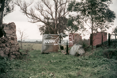
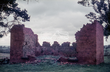
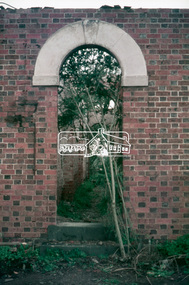
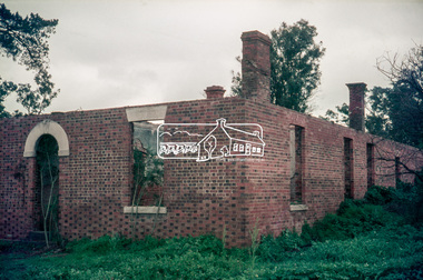
 Eltham District Historical Society Inc
Photograph, Fay Bridge, Former Glynn's Dairy Farm, Glynns Road, North Warrandyte, 31 August 2018
... . The fine brick home was destroyed on Black Friday (13 Jan.) 1939.... The fine brick home was destroyed on Black Friday (13 Jan.) 1939 ...Glynn’s farm Originally Section 7, Parish of Nillumbik marked Aborigine Reserve in 1866 Crown Allotment 8, Section 7, Parish of Nillumbik, County of Evelyn, Certificate of Title Volume 4095, Folio 818.835, approx. 93 acres purchased by Joseph Panton in 1881 for £1/acre and known as Panton’s Point. By 1924 owned by S.S. Sergeant and called Riverswood. Sergeant commissioned Edna Walling to design the garden. In September 1929 the property was sold at auction by Mortgagee’s sale. Described as well built, brick, tile roof, Attic Villa containing downstairs 7 good rooms, bath, scullery, inside lavatory, etc. Upstairs 2 bedrooms and sleep out. Outbuildings compromising of brick and weatherboard wash house, stables, workshop, feed room, cow bails, large G.I. Hay shed, etc In January 1931 Riverswood property was proclaimed a sanctuary for native game for the entire year. A private swing bridge crossed the river at Pound Bend was known as Pearson’s bridge after C.W.K. Pearson who bought Riverswood in the early 1930s. The bridge was swept away in the December 1934 floods. Riverswood was sold by C.W.K. Pearson at auction on 25 November 1936. Described as a beautiful farm home of 93 acres and over one mile of River Yarra frontage, modern brick residence, lovely garden, rich river flat pastures, model poultry farm. The fine brick home was destroyed on Black Friday (13 Jan.) 1939. It was still a ruin when the Evelyn Evans purchased Waikowhane above Riverswood in 1940. The Glynn family purchased the Riverswood property in 1941 from Robert and Emily Hannon. Their son Kenneth Patrick Glynn inherited the property and he set about clearing the land during WW2 selling wood. Prior to marriage, Kenneth was living alone on the farm in a house he had built from whatever was available. He used the bluestone foundations from the original fine brick home. He met and married Honora Elizabeth Drew in early 1945 and their daughter Anna grew up on the farm. It was compulsorily acquired by the Board of Works in 1976 who then rented the house out in the 1980s. The property was transferred to Melbourne Parks and Waterways in 1996. Waikowhane was a pretty timber house built on top of the hill on 50 acres above Riverswood by retired nurse Jessie MacBeth. (This would be at the intersection of Glynns Road and Overbank Road where the big water tank is now situated on what was once James Orford’s property.) It was also destroyed Black Friday and she rebuilt it from the plans living in a caravan on site supervising the build. It was almost complete when she died May 1939. The property was bought by Evelyn Evans (a city girl) and her estranged husband in 1940. She had two sons, one only 9 months old at the time. It was a timber house with no power or water connected. The Ewen Cameron family bought Waikowhane in 1957. They had to evacuate when the 1961 bushfires swept through. The house was saved by Matcham Skipper. It was demolished by Melbourne Water in the 1990s when they acquired it.fay bridge collection, 2018-08-31, glynn's, glynn's dairy farm, glynns road, north warrandyte, parks victoria, ruins, riverswood, kenneth patrick glynn -
 Surrey Hills Historical Society Collection
Photograph - Digital photograph, George L Coop, 690 Whitehorse Road, Mont Albert 1958, 1958
... . A wire fence divides the 2 properties. No 690 is a red brick... the Coop family home at 688 Whitehorse Road. Ralph Walton ...The donor George Lister Coop was about 21 years of age when he took this photo in 1958 from the Coop family home at 688 Whitehorse Road. Ralph Walton, a bricklayer, and his wife Maria lived at 690 Whitehorse Road from c1931 (when it was numbered 447) until their deaths. Maria died in 1944 aged 77 years and Ralph died in 1959 aged 85 years. Whitehorse Road was renumbered in 1936.A view from the adjacent front garden of 690 Whitehorse Road, Mont Albert which includes some garden details of 688. A wire fence divides the 2 properties. No 690 is a red brick Californian bungalow style home with a tiled roof and a veranda offset to the eastern side.george l coop, whitehorse road, mont albert, ralph walton, maria walton, californian bungalow -
 Greensborough Historical Society
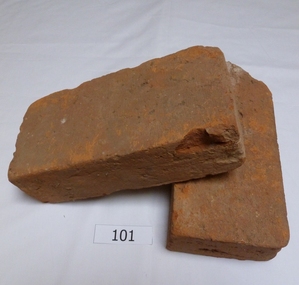
Functional object - Bricks, Hand made bricks from Partington house (Willis Vale) Greensborough, 1840c
... Bricks from "Willis Vale' home of the Partington family... Plenty Lower Plenty melbourne Bricks from "Willis Vale' home ...Bricks from "Willis Vale' home of the Partington family of Greensborough. Built in 1840, Willis Vale was owned by the Partington family from 1878 to 1947. It was a 2 storey house overlooking the Plenty River and set in 150 acres of farmland. The Partingtons moved out in 1947 and the house was vandalised shortly after. It was destroyed by fire in the 1960s.The bricks are a link to pioneer homes and farms in the area.Hand made clay bricks, light red in colour. All faces are flat.. One brick is chipped. Accompanying note: Hand made bricks from Partington house in Greensborough. Donated by Alan Partington.willis vale, partington family, greensborough, alan partington, bricks -
 Surrey Hills Historical Society Collection
Photograph - Digital photograph, George L Coop, 692-694 Whitehorse Road Mont Albert, 1958, 1958
... he took this photo in 1958. This photo is of Annesley Home... in 1971. A Queen Anne / Edwardian brick attic home was built ...The donor George Lister Coop was about 21 years of age when he took this photo in 1958. This photo is of Annesley Home for the Aged at 692-694 Whitehorse Road. It was originally a Methodist, later a Uniting Church facility. The new sections in the photo was part of an extension built in 1958. A further extension encompassing 21 beds occurred in 1971. A Queen Anne / Edwardian brick attic home was built on No 694 in 1908 for William Pilkington, a manufacturer and was called 'St Martins'. Ownership stayed in this family until c1950. It was retained as part of the facility. Alan Holt's register of 3127 properties list 34 residents in 1980, of which all but 3 were female. The property was replaced by apartments in c2018 but had ceased function as a nursing home quite a number of years prior to this and in the interim appeared to be used for temporary accommodation. A street view of new brick veneer 2 storey extensions to Annesley Home for the Aged. It does not show the original home 'St Martin's' that the facility was built around. In the foreground the pile of soil relates to the excavation works undertaken in widening Whitehorse Road.george l coop, whitehorse road, mont albert, annesley home for the aged, uniting church, st martins, pilkington family -
 Stawell Historical Society Inc
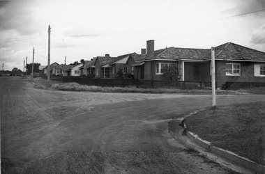
Photograph, Housing Commission House in Dawson Street -- Photo & Newspaper Clipping
... The first Housing Commission homes of brick and tiled roof... grampians The first Housing Commission homes of brick and tiled roof ...The first Housing Commission homes of brick and tiled roof built after WW2 in Stawell Dawson Street c 1950's. Also in the file a Newspaper clipping from News, Saturday, October 11. 1947. "George Mitchell Square" the first Housing Commission homes built in Stawell. George Mitchell was a member of Borough Council for 40 years and Mayor for 4 years. The housing estate was named in his honor. The architects "Buchannan Laird & Buchanan Geelong.Black and white photograph of a street scene. The photograph shows a line of brick houses along the street with timber fences. Four electric power lines are along the street with 2 in the distance. The street also has curb and guttering. The street to the right has a street post with "George Mitchell St" written on the street sign.stawell -
 Melton City Libraries
Newspaper, Special Melton People, 1971
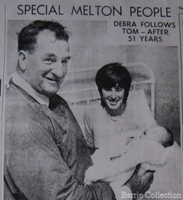
... a bluestone and mud brick home. It is believed that while travelling... a bluestone and mud brick home. It is believed that while travelling ..."Hannah ‘Grannie’ Wattsis one of Melton’s mostcelebrated and cherished pioneers. Born in Ireland in 1831, Hannah immigrated to Australia with her husband George Byrns in 1854. Moving to Melton, they built a wattle and daub hut home where they lived with their four children until George was tragically killed in 1860. Unusually for the time, Hannah purchased land in her own name in the Melton township in 1863. Later that same year she married William Watts and together they moved to Toolern Vale and built a bluestone and mud brick home. It is believed that while travelling to Australia, Hannah assisted the ship surgeon and demonstrated a natural aptitude for the tasks assigned to her. When she was living in Melton she assisted other women in an unofficial capacity as neighbourhood midwife, while also working on her farm and raising her six children. By 1887, however, her reputation as a midwife had grown to such an extent that she was able to establish her own practice. William Watts died in 1874, but Hannah remained in Toolern Vale for the next twenty years. In 1894, she moved into the Melton township and built Lynch Cottage on the corner of Yuille and Sherwin streets, near Toolern Vale Creek. There she assisted in the births of hundreds of Melton residents, as well as the laying out of the deceased. Meticulous in her record keeping, Hannah Watts recorded the details of a total of 442 births between the years 1886 and 1921. Lynch Cottage was officially registered as a private hospital in 1911 and Hannah was listed in the Victorian Register of Midwives in 1917. Hannah Watts died on 21 October 1921, a few months after she assisted with the delivery of her final baby, Thomas Watts Minns. She was 90 years old. Hannah was buried in Melton Cemetery and mourned by the Melton community. Her obituary in the Gisborne Gazette is a testament to how beloved she was by the people she served: ... while in the absence of medical aid residents looked to Grannie as their doctor, philosopher and friend. Hundreds, in fact we might say thousands of people held the deceased in veneration ... A woman of great energy and determination combined with superior intelligence, Grannie conquered difficulties that would have made many falter... Today Grannie Watts is remembered by her descendants and by many locals in the City of Melton. Created in 1985, Hannah Watts Park honours Grannie Watts’ pioneering work for the health and wellbeing of hundreds of Meltonians. Not only is the park a fitting tribute to the memory of an outstanding citizen, it also continues to provide today’s residents and visitors with a space to walk, relax, gather and celebrate in Melton" .Tom Minns holding Debra Wain, first hospital baby to be born In Melton since 1921. Article featured in the Herald. Mother Rhonda Wain is featured in the photo too. local identities, local significant events -
 Eltham District Historical Society Inc
Photograph, Woodburn residence, mudbrick adobe (1949), Eltham Heritage Tour, 24 May 1992, 24/05/1992
... homes', mud-brick or pise, rammed dirt. Crossing Main Road... with a sprinkling of 'earth homes', mud-brick or pise, rammed dirt. Crossing ...ELTHAM HERITAGE TOUR The Society excursion on 24th May 1992 was arranged by David Bick, leader of the team carrying out the Shire's heritage study. David selected a number of sites or buildings identified in the study, some of them lesser known components of the Shire's heritage. The tour commenced at the Eltham Shire Office at 10.00 am. Travel was by private car and mini-bus with stops at about twelve locations for commentary by David.It included a short walk in Hurstbridge and lunch at Kinglake. Highlights of the tour included: - 10 am Leave from Shire Offices - 3 Important Trees - A Physical Link to Eltham's First Settlers - Toorak Mansion Gates - A Surviving Farm House - An Intact Circa 1900 Main Street - First Settlers - Gold Miners, and Timber-getters - An Early Hotel - A Pioneering Homestead - Changing Eltham Shire - 20th Century - 4 pm Afternoon Tea and Finish Tour Extract from ELTHAM CULTURAL HERITAGE TOUR (Newsletter No. 85, July 1992, by Bettina Woodburn) "In some respects Eltham is a 'back-water' and it has its own distinctive flavour. On the outskirts the homes date from the 1960's, 70's and 80s with a sprinkling of 'earth homes', mud-brick or pise, rammed dirt. Crossing Main Road into Beddoe Street and Thompson Crescent a very pleasant drive past pines and old fence lines, front lawns unfenced, the occasional ·old farm building, we eventually looked down on a huge circular roof of a 1992 adobe home. Other distinctive places included the Pauline Toner Butterfly Reserve, Gordon Ford's splendid garden at Fulling in Pitt Street, cypress hedges and old houses in Bridge Street and in every direction Eltham's special feature - a totally treed horizon. We were now in the part of the Shire closest to Melbourne - Montmorency - not on the way to anywhere, with no through road going across it, developed in the 1950's and 1960's with conventional gardens, now converted to native plants. The rail looped between Greensborough and Eltham and a shopping street (Were Street) served the area, growing up the hill from the station. It was a typical outer Melbourne suburb with lawns and roses with patches of originality. The shopping precinct still has 1950 characteristics - walls which sloped back, projecting roofs, the original shop fronts are nearly all tiled below the old windows. There's an air of past times about the School, the Dairy, the Butcher's (now a milk bar) and the Castlemaine stone face of the Commonwealth Bank. The final stop for the tour was at the mud-brick Woodburn residence, adobe of 1949 with additions. After War Service, Bill Woodburn had commenced an Architecture course at Melbourne University and after second year in the Christmas vacation, with his wife, Betti, built the two bedroom house - with amazing saving of costs. In the three and a half months they made over 3000 bricks (external walls 18" x 12" x 4", internal walls 12" x 9" x 4"), sifted top soil for mortar and laid them, on concrete foundations and slab floor, made all the structural window frames, door frames and roof members to carry 'super six' asbestos sheets, laboured for the electrician and plumber, did all the glazing and, still without electricity, moved in in March 1949. Rooms have been added, at first with glass walls, later using concrete blocks, to accommodate three daughters and a son. The house not only grew from the earth, but also with the family."Record of the Society's history and activities and highlighting various aspects of the Heritage Study undertaken by David Bick used to create the future heritage overlay for the Shire of Eltham and later Nillumbik Shire.Roll of 35mm colour negative film, 4 stripsKodak Gold 100 5095shire of eltham historical society, activities, heritage tour, woodburn house -
 Eltham District Historical Society Inc
Photograph - Digital Photograph, Marguerite Marshall, Sutherland Home for Children, Diamond Creek, 27 September 2007
... in February, 2000.2 The Sutherland Homes red-brick and stuccoed... in February, 2000.2 The Sutherland Homes red-brick and stuccoed ...The Sutherland Homes for Children on Yan Yean Road, Diamond Creek cared for thousands of children from when it was opened in 1912. The site closed for this purpose in 1991 and was sold and later developed for commercial and office purposes. Covered under Heritage Overlay, Nillumbik Planning Scheme. Published: Nillumbik Now and Then / Marguerite Marshall 2008; photographs Alan King with Marguerite Marshall.; p107 The Sutherland Homes for Children at 14 Yan Yean Road, Diamond Creek, cared for thousands of children since they opened in 1912, after beginning at La Trobe Street, Melbourne in 1908. In 1994 Sutherland Homes (then called Sutherland Child, Youth and Family Services) amalgamated with Berry Street Child and Family Welfare. Together as Berry Street Victoria, they formed Victoria’s largest independent provider of support and accommodation services for children, young people and families in crisis.1 However with the move from institutional to community care, the Diamond Creek site had not been used since 1991 and was sold to private purchasers in 1999. More than 2000 former residents, staff, neighbours and friends attended a farewell in February, 2000.2 The Sutherland Homes red-brick and stuccoed building in Diamond Creek (a rare design in the Eltham Shire), was opened in 1929 by Lord Somers, the Governor of Victoria. Destitute children lived in dormitories bathed in natural light through large windows. However in 1958 as the cottage–parent system replaced the dormitory system, the first of eight residential cottages accommodating ten to 12 children was built. The site also included Special School 3660 and a farm, and the children were able to form relationships with people outside Sutherland, by staying with holiday hosts. Children were originally placed at Sutherland because of extreme poverty, or because single parents could not cope. However later, most placements occurred due to family violence, abuse or neglect. The property was originally bought from the Crown in 1869 by Timothy Mahony. Later owner, Augusta Meglin, ran a 40-acre (16ha) farm there. In 1909 she bequeathed this, including the house, orchards, vegetable gardens, vineyards and the balance of her income to The Sutherland Homes for Neglected Children. Sutherland Homes’ founder, Selina Sutherland, was known as ‘New Zealand’s Florence Nightingale’. In 1888 she became Victoria’s first licensed ‘child rescuer’3 and was to rescue around 3000 waifs from Victoria’s streets and slums.4 Born in Scotland in 1839, Sutherland joined her sister, who had emigrated with her husband to New Zealand. Sutherland trained as a nurse and led the establishment of a public hospital at Masterton. In 1881, while holidaying in Melbourne, Sutherland was so touched by seeing young people living under Princes Bridge, that this determined her future work. Meanwhile Sutherland instigated the Melbourne District Nursing Society, (now Royal District Nursing Service). She also led the founding of The Victorian Neglected Children’s Aid Society (now Oz Child) and the Presbyterian Neglected Children’s Aid Society (now Kildonan). From 1894 Miss Sutherland was Melbourne’s best known woman and cut a distinctive figure, wearing an alpine hat with a prominent feather. In 1906 Prime Minister Alfred Deakin named her Melbourne’s most successful philanthropic worker. However she was to face some difficult times. That year she suffered severely from an injured shoulder and dizzy turns and was pressured to resign as Superintendent of The Victorian Neglected Children’s Aid Society. In 1908 the committee of management offered her 12 months leave with pay. Sutherland declined – but soon after, was dismissed. However she continued her work from Latrobe Street, Melbourne, with the help of Sister Ellen Sanderson and several committee members. Sutherland attempted to register her new organisation but the Victorian Neglected Children’s Aid Society objected to the government, alleging that Sutherland, because of increasing infirmity, was unable to satisfactorily carry out such duties. They accused her of cruelty and of intoxication. However the charges were not proven, so The Sutherland Homes for Neglected Children was registered.5 Sadly, in 1909 Sutherland died, the day she was to move the children to the ‘country property’ at Diamond Creek. At her death she owned less than £10. Today Berry Street recognises Sutherland’s enormous contribution to child welfare with a memorial and an annual Selina Sutherland Award, presented to an outstanding volunteer.This collection of almost 130 photos about places and people within the Shire of Nillumbik, an urban and rural municipality in Melbourne's north, contributes to an understanding of the history of the Shire. Published in 2008 immediately prior to the Black Saturday bushfires of February 7, 2009, it documents sites that were impacted, and in some cases destroyed by the fires. It includes photographs taken especially for the publication, creating a unique time capsule representing the Shire in the early 21st century. It remains the most recent comprehenesive publication devoted to the Shire's history connecting local residents to the past. nillumbik now and then (marshall-king) collection, diamond creek, sutherland home for children -
 The Beechworth Burke Museum
Photograph
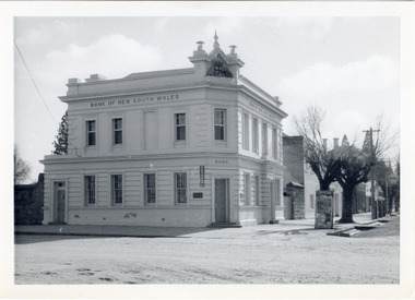
The old Bank of New South Wales building is located on the corner of Camp and Ford streets in Beechworth, Victoria. It was constructed between 1856 and 1857 from local honey coloured granite. It was designed by architects Robertson & Hale and is a two-storey rendered brick building and the original coat of arms is still visible. The coat of arms is distinctive and consists of a kangaroo, emu, lion, and rising sun. The rear of the building was surrounded by high granite walls for security as it was the original home for the local gold office. Beechworth Honey currently offers tourist accommodation in the Hive Apartment located in the former Bank of New South Wales Managers residence.The Bank of New South Wales building in Beechworth is significant for its location in one of Australia's most prominent goldfield towns. Of particular interest is the use of distinctive local Beechworth honey coloured granite in its construction. The building’s architecture is a simple, conservative classical style known as Renaissance Revival. It is one of the few known surviving works of the architects Robertson and Hale. The decorative composition above the main entrance and the counter in the banking chamber are of special interest.Black and white rectangular photograph printed on cardAHold bank of new south wales, bank of new south wales building, beechworth bank of new south wales, bank of nsw, beechworth 1850s, robertson and hale, architects robertson and hale, rendered brick, coat of arms, granite walls, local honey coloured granite, gold office, 1856, 1857, beechworth, beechworth honey, hive apartment, manager's residence, renaissance revival -
 The Beechworth Burke Museum
Photograph - Lantern Slide, c1900
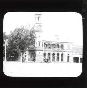
This glass slide presents an image of the Old Beechworth Post Office and was taken in the year 1900. The building displayed within the image is not that of the post office in its original form; the post office originally consisted of only a simple wooden building. With the establishment and growth of new towns across Victoria, as well as an increased need for more consistent communications with the City of Melbourne, this modest building was soon deemed inadequate. In 1858 it was brought into the style of the changing times, with the tall clock tower added in 1865. This transition aligned with a pattern of refurbishment and conversion of many Beechworth buildings (which could be seen during the 1860s-70s), aiding in the growth and prosperity of the town. Early makeshift homes were turned into more substantial dwellings, featuring elements such as weatherboard, brick, and granites materials, and gabled or hipped roofs with iron lacework fringing the verandah. These refurbishments were temporarily halted in March of 1867 when a fire swept through the town, damaging many buildings including the post office. This led to further reconstructions on the building, including heightening of the clock tower, and in 1870 the two-storey Italianate style building was completed. The Old Beechworth Post Office itself also holds significance due to its connection with one of Australia's most infamous families. It reportedly played an important role in communicating the news of the 1880 murders of police at Stringybark Creek by the Kelly Gang. Lantern slides, sometimes called 'magic lantern' slides, are glass plates on which an image has been secured for the purpose of projection. Glass slides were etched or hand-painted for this purpose from the Eighteenth Century but the process became more popular and accessible to the public with the development of photographic-emulsion slides used with a 'Magic Lantern' device in the mid-Nineteenth Century. Photographic lantern slides comprise a double-negative emulsion layer (forming a positive image) between thin glass plates that are bound together. A number of processes existed to form and bind the emulsion layer to the base plate, including the albumen, wet plate collodion, gelatine dry plate and woodburytype techniques. Lantern slides and magic lantern technologies are seen as foundational precursors to the development of modern photography and film-making techniques. This glass slide captures social and historical significance as it displays the Old Beechworth Post Office in 1900, a building that demonstrates the prosperity and growth of Beechworth as a town during this time period. This slide also holds a level of aesthetic significance due to the Italianate style building that is featured in its image; a style that became very popular during the nineteenth-century. Thin translucent sheet of glass with a square image printed on the front and framed in a black backing. It is held together by metal strips to secure the edges of the slide.Obverse: x / burke museum, beechworth, lantern slide, slide, glass slide, plate, burke museum collection, photograph, monochrome, beechworth post office, beechworth post office kelly gang, 1900, 1900 beechworth, growth of beechworth, 1867 beechworth fire, old beechworth post office, beechworth post office reconstructions, italianate style, italianate style buildings, italianate style beechworth post office