Showing 10994 items matching " land"
-
 Ringwood and District Historical Society
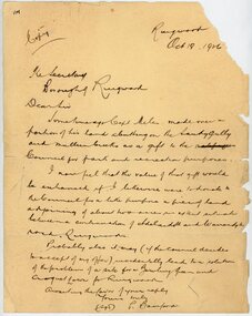
Letter, From Philip Bamford to Borough of Ringwood gifting a parcel of land for park and recreation purposes
1929 saw the establishment of the Ringwood Bowls Club initially located on the land now occupied by the Eastland Shopping Centre. It moved to its current location in Loughnan Road, Ringwood in 1997.Hand-written letter from Philip Bamford to To Borough of Ringwood's Town Clerk giving a parcel of land for park and recreation purposes. Probable site for bowling green and croquet lawn. The land would adjoin similar donation from Capt Miles [Miles Park]. Dated 18th October 1926.city of ringwood bowls club, ringwood bowling club, ringwood bowls club, lawn bowls, bowling -
 Bacchus Marsh & District Historical Society
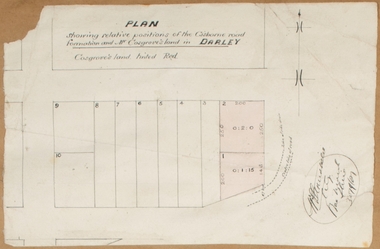
Map, Plan showing relative positions of the Gisborne road formation and Mr. Cosgrove's land in Darley. 1907
No background information about the roadworks referred to in this plan has been found. The portion of land referred to as 'Cosgroves' in this plan is located close to the present day Darley Park Recreation Park in Darley, near Bacchus Marsh. The land indicated appears to be close to the corner of Grey Street and Gisborne Road. James Cosgrove who died in 1923 aged 65 owned a farm of 52 acres in this area of Darley.Single page map showing a proposed deviation of the Gisborne road in Darley and its position relative to land owned by Mr. Cosgrove. The land owned by Cosgrove is shaded in pink. No scale indicated. Part of a set of maps which are pasted into a bound volume containing 76 maps or plans in total. High resolution digital image stored on BMDHS computer network. Signature (illegible), Eng, Bac Marsh Shire, 30/9/07bacchus marsh roads and streets, darley victoria maps -
 Ringwood and District Historical Society
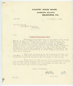
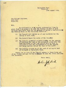
Letter, From Country Roads Board re compensation for road-widening land from Mr Bamford in 1929
1929 saw the establishment of the Ringwood Bowls Club initially located on the land now occupied by the Eastland Shopping Centre. It moved to its current location in Loughnan Road, Ringwood in 1997.From Country Roads Board re compensation for road-widening land from Mr Bamford. Dated 14th March 1929.city of ringwood bowls club, ringwood bowling club, ringwood bowls club, lawn bowls, bowling -
 Whitehorse Historical Society Inc.
Document, Community participation with land use
Community participation with land use - a Nunawading example.Community participation with land use - a Nunawading example. Edited version of a paper presented at 'Land for Leisure', annual conference of the Royal Australian Institute of Parks and Recreation, Burnie, 1978. Includes introduction and colour thumbnail prints of slides which were part of the presentation. 3 Cds contain images NP2904-2906.Community participation with land use - a Nunawading example. community gardens, city of nunawading. parks and recreation -
 Bacchus Marsh & District Historical Society
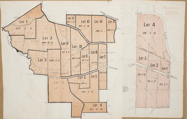
Map, Glenvale Estate and Glenmore Estate Land Sales 1909
The two land auction plans shown in this record relate to the sale of land from the Glenmore Estate property. The Glenmore property was established by C.J. (Charles James) Griffith and James Moore around 1840. Moore sold his interest to Moelesworth Greene in 1848. Greene was the nephew of the other owner Charles Griffith who died in 1863. From around the 1870s onwards parts of the Estate were subdivided and put up for sale or lease. In subsequent decades more changes in ownership occurred. These two plans document another major sale of the land from the original Glenmore Estate including part of the estate which had become used for dairy farming and was at that time known as the Glenvale Estate. Two single page maps pasted together on a single page of a bound volume of maps. One map shows 15 separate lots of land for sale. The other map which has the words 'Glenvale Estate' at the top of the map shows 4 lots of land for sale. Both parcels of land were originally part of the Glenmore Estate a pastoral holding belonging to C.J. Griffith and James Moore which the began in the Rowsley area south west of Bacchus Marsh in the 1840s. The maps are pasted into a bound volume containing 76 maps or plans in total. High resolution digital image stored on BMDHS computer network. bacchus marsh victoria maps, glenvale estate property, glenvale estate land sales, glenmore estate, glenmore station -
Whitehorse Historical Society Inc.
Letter - Correspondence, McGlone land, 2/12/1921 12:00:00 AM
Letter from T.R.B. Morton & Son to W.J. McGlone.Letter from T.R.B. Morton & Son to W.J. McGlone about terms for a possible sale of land the the corner of Whitehorse Road and Elizabeth Street, Mitcham, 2 Dec 1921.Letter from T.R.B. Morton & Son to W.J. McGlone.mcglone, william j., t.r.b. morton & son, whitehorse road, mitcham, elizabeth street, mitcham -
Whitehorse Historical Society Inc.
Document, Land for leisure, 1978
Papers presented at the annual conference of the Australian Institute of Parks and Recreation at Burnie, Tasmania, 1978.Papers presented at the annual conference of the Australian Institute of Parks and Recreation at Burnie, Tasmania, 1978. Includes paper by John P. Brandenburg titled 'Community participation with land use - a Nunawading example.'Papers presented at the annual conference of the Australian Institute of Parks and Recreation at Burnie, Tasmania, 1978. brandenburg, john p, nunawading community gardens, royal australian institute of parks and recreation -
 Hume City Civic Collection
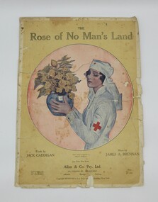
Music Book, The Rose of No Man's Land
Words and music of popular song about Red Cross Nurses during World War 1.Music book, yellow background with Red Cross Nurse holding vase of flowers on front cover. Three loose pages. 407 $1 written in pencil on front. In fragile condition.front "The/Rose of No Man's Land/ words by..."music, red cross, world war 1, george evans collection -
 Ringwood and District Historical Society
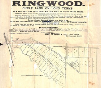
Flyer, Land Sale Advertisement, Ringwood, Victoria - 1894
Land sale advertisement for 10 and 20 acre lots from £5 per acre on eight years' terms in Ringwood, with description of local facilities and agricultural features.Subdivision map includes Mullum Mullum Road, Wonga Road, Oban Road and Anderson's Creek Road (later Warrandyte Road). Markings on reverse side indicate the sheet was sent by post from John McEwan & Co., Auctioneers, Land Agents & Business Brokers, 71 Swanston Street, Melbourne, to Mr Allan, Builder, Ringwood, postmarked in JE (June), 1894. -
 Whitehorse Historical Society Inc.
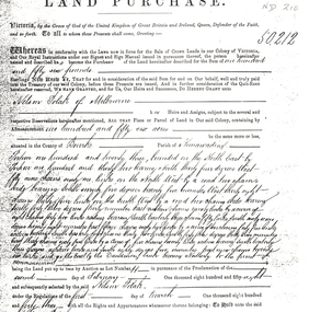
Document - Land Title, Land purchase, 31/07/1858
Record of land purchase by Louis Laurence Smith dated 31 July 1858. The land is adjacent to Dandenong Creek. Records of the transfer of the land in June 1895 are included. Photocopies.dandenong creek, smith, l l dr, william, gallien, jacque jean, speary, catherine, langdon, harry joseph, foster, john, youngman, edward, simmons, morris, mayfield, william george, marion, land sales -
 Ringwood and District Historical Society
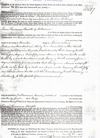
Letter, To Borough Engineer from Arthur Blood confirming gift of land adjoining Bowling Green for road-making purposes
1929 saw the establishment of the Ringwood Bowls Club initially located on the land now occupied by the Eastland Shopping Centre. It moved to its current location in Loughnan Road, Ringwood in 1997.Typed letter to Ringwood Borough Engineer from Arthur Blood confirming gift of land adjoining Bowling Green for road-making purposes. Dated 10th August 1930.city of ringwood bowls club, ringwood bowling club, ringwood bowls club, lawn bowls, bowling -
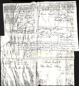 Whitehorse Historical Society Inc.
Document - Land Title, Land Transfers, 30/11/1884
Photocopy of records of land transfers of land belonging to William Logan dating from 1882 to 1884logan, william, longley, annie caroline, sarah, whiting, robert salmon -
Ringwood and District Historical Society
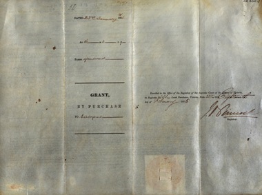
Land Titles Documents, Titles Department, Documents of land transfer 1911and Certificate of title for land in Pitt Street Ringwood 1920 plus list of names of transferees, 1911 -1920
Photocopies of transfer of land 1920 (poor quality) 1 copy A3, 1 A4. Certificate of title 1920, A4 and list of transferees for land in Bedford Road and Pitt Street Ringwood +Additional Keywords: Walker, E.E Thomas,A / E Thomas,A / Wisemann, A. / Edelsten, E / Unsworth,M -
Whitehorse Historical Society Inc.
Letter - Correspondence, Letter re land tax, Strathdon, 4/08/1961 12:00:00 AM
Letter from State Land Tax office to Mrs Mary Matheson re land on Springvale Road.Letter from State Land Tax office to Mrs Mary Matheson re land on Springvale Road.Letter from State Land Tax office to Mrs Mary Matheson re land on Springvale Road.matheson, mary, strathdon community -
Whitehorse Historical Society Inc.
Article, Couple give land for park, 21/01/1967 12:00:00 AM
Article from The Age, 21 Jan 1967.Article from The Age, 21 Jan 1967, re Blackburn couple Arthur & Janet Cooke deciding to hand over their house and land to the Council on their death to keep as a sanctuary for birds, plants and flowers.Article from The Age, 21 Jan 1967. hooke, albert arthur, hooke, janet emily, wandinong sanctuary -
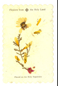 Federation University Historical Collection
Plant specimen, Flowers from the Holy Land, possibly c1949
This item was located in a book called The English Lakes which was owned by E.C. Holmes [Edward Carter Holmes was the name of my mother's, Elizabeth Mary [Elizabeth] Holmes family's pioneer settler. He arrived in Geelong on the 28th of June, 1849, with his wife Sarah and their first child Frances Harriet as assisted immigrants (people whose passage was subsidised by an assisted immigration scheme) to New South Wales at Port Henry, Geelong in the sailing boat ‘Larpent’. Sarah and Edward arrived two years before his mother, Harriet, arrived as unassisted passenger in Geelong on ‘The Eagle’. 200 of the " Larpent" passengers had been selected in England by Rev John Dunmore Lang whose wish was to encourage the migration of hard-working, God-fearing Protestants to the colony. He sponsored two ships, the "Travancore" and the" Larpent', to bring the settlers to Australia in 1849 with Dr Alexander Thomson, a Sydney Presbyterian minister, ready to receive and settle them. Thomson owned section 10 of the parish of Barrabool known as the Kardinia section — a square mile of undulating land west of Colac, still known today as Larpent. Among the 'Larpent' immigrants were many well-known Ballarat and District pioneers including Armitage, Mercer, Oddie and Scott. For more details about this migration scheme refer to: A thoroughly Protestant emigration: the emigration activities of the Rev. Dr. J.D. Lang / Ian Wynd.2006.] [source: Jane Dyer 2024] Printed card with a pressed botanical specimen glued onto it. Printed onto the card 'Flowers from the Holy Land. Placed on the Holy Sepulchrechatham family archive, chatham, holmes, ec holmes. holy land, relic, botanical, botany, holy sepulchre, botanical specimen -
University of Melbourne, Burnley Campus Archives
Booklet, The University of Melbourne, The University of Melbourne Institute/Faculty of Land and Food Resources Postgraduate Handbook, 2003-2007
the university of melbourne, institute of land and food resources, faculty of land and food resources, postgraduates, handbook, courses -
 City of Kingston
Pamphlet - Colour, R. Malcolm Estate Agents et al, Last Chance Land Sale Heritage Estate Cheltenham, c.1994
Sales plan for land in the suburb of Cheltenham, bounded by Chesterville Road and Bernard Street, and incorporating Clendon Court, Tintern Grove and Tintern MewsThis land sale pamphlet illustrates one of the last subdivisions of the century in Cheltenham, incorporating house and land packages. It shows that land sales and subdivision for the area had slowed considerably by the end of the 1900s and that the infrastructure was significantly developed. Colour pamphlet advertising last chance land sale of Heritage Estate Cheltenham. Incorporates a map of the estate bordered by Chesterville Road and Bernard Street, and including Clenton Court, Tintern Grove and Tintern Mews.cheltenham, land sales, estate -
University of Melbourne, Burnley Campus Archives
Document - Prospectus, School of Land and Environment, Graduate Prospectus, 2011
courses, graduates -
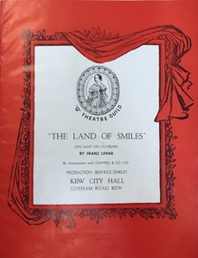 Kew Historical Society Inc
Programme, The "Q" Theatre Guild, The Land of Smiles, 1961
The "Q" Theatre Guild was formed out of the Kew Light Opera Company in 1957. It marked the transition of the company that had initially been directed by Lance Nicholls to one directed by Beatrice Oakley. It continued to perform in the Kew Recreation Hall, but, with its demolition in 1960, and the opening of the new Kew City Hall in Cotham Road, moved its productions to that venue. Productions of the "Q" Theatre Guild included The Geisha (1957), Maritana (1958), They All Do It (1959), Blossom Time (1959), Love's A Luxury (1959), There And Back & The Bohemian Girl (1960), Die Fledermaus (1960), Gay Rosalinda (1961), The Land Of Smiles (1961), Kisses For A Kid & Hansel And Gretel (1961), Die Fledermaus (1962), Monsieur Beaucaire (1964), Macbeath or The Beggar's Opera, and So To Bed.The scrapbook of annotated photographs, programmes, and newspaper reviews of which this item is a part was assembled by Marion Tilley, wardrobe mistress for, and performer in, productions by the Kew Light Opera Company and the "Q" Theatre Guild. It is significant as a remarkably complete document of theatre performances in Kew, Victoria during the 1950s and 1960s. The scrapbook, and the items individually catalogued within it, have artistic and aesthetic significance within the history of performing arts in Victoria in the middle of the 20th Century. They have social significance in that they reveal socio-cultural values and preoccupations during the period. The records also act as a history of arts activities in the Kew Recreation Hall and later in the Kew City Hall as entertainment and community arts and music precincts.Souvenir programme issued by the "Q" Theatre Guild for a performance of Franz Lehar's The Land of Smiles in 1961. The production was performed at the Kew City Hall. The Cast List includes annotations by Marion Tilley. This was the first time that The Land of Smiles had been performed in Melbourne."q" theatre guild, performimng arts, kew city hall, the land of smiles (lehar) -
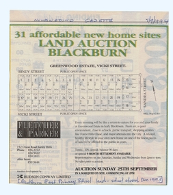 Whitehorse Historical Society Inc.
Article, Land Auction, Blackburn, 7/09/1994 12:00:00 AM
old Blackburn Advertisement in the Nunawading Gazette 7 September 1994Advertisement in the Nunawading Gazette 7 September 1994 for auction of the old Blackburn East Primary School (closed December 1993) land. Auction 25 September 1994. Greenwood Estate, Nicoli Street.old Blackburn Advertisement in the Nunawading Gazette 7 September 1994 land subdivision, bindy street, blackburn south, vicki street, sandra street, blackburn east primary school, no. 4800 -
 Federation University Historical Collection
Document, Victoria: Land Purchase, Edward Ager Wynne, 1856, 23 January 1856
.1 Document outlining the purchase of Lot No. 39: 16 acres, 3 roods, 9 perches situated in the County of Talbot, Parish of Glendaruel by Edward Ager Wynne of Melbourne for the sum of Seventeen Pounds Thirteen Shillings .2 Document outlining the purchase of Lot No. 30: 50 acres, 2 roods, 38 perches situated in the County of Talbot, Parish of Glendaruel bu Edward Ager Wynne of Melbourne for the sum of Fifty Pounds Fourteen Shillings and Nine Pence Both documents were witnessed by Major-General Edward Macarthur the Senior, Officer in Command of Our Land Forces Thick cream paper, hand writtenDate: 23 January 1856 Signature: E Macarthur - Major General of Our Land Forces Official Seal county of talbot, parish of glenaruel, acres, roods, perches, edward ager wynne, major-general, edward macarthue, land purchase agreement -
 Orbost & District Historical Society
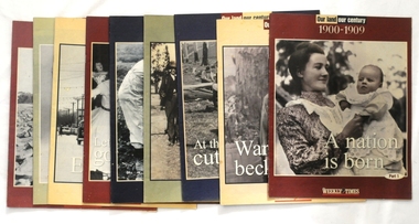
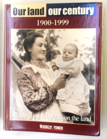
magazines/booklets, Our Land/Our Century, 1999
The Weekly Times was first published on September 11, 1869. In September 1875, The Weekly Times absorbed two other Melbourne-based rural publications, the Economist and Town and Country.In 1892 the Daily Telegraph company sold its buildings and mastheads to the Herald group, which has published The Weekly Times continuously since. In 1902 The Herald and Standard Newspaper Company Ltd changed its name to the present Herald and Weekly Times. These booklets were published as souvenir magazines to "celebrate 100 years on the land". These magazines are records of the rural history of Victoria.Nine of ten Weekly Times souvenir booklets/magazines titled Our Land, Our Century 1900-1999: Celebrating 100 Years on the Land. They contain pictures and stories of events related to rural Australia. Each edition covers ten years from 1900 -1989. The issue, 1990 -1999 is missing.magazine weekly-times souvenir rural-history -
 Victorian Aboriginal Corporation for Languages
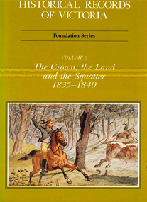
Book, Michael Cannon, Historical records of Victoria : foundation series : volume 6 : the crown, the land and the squatter 1835-1840, 1991
Reproductions of various transactions and reports dealing with squatting, land tenure and agricultural production in Port Phillip in the years 1835-1840. A history of land grants, surveying, squatters? life and land use during this period.maps, b&w illustrations, colour illustrationsvictorian history -
 Linton and District Historical Society Inc
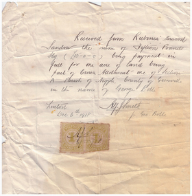
Receipt, Receipt for Payment for a Block of Land near Linton, 1918
Note that the block of land which was traded was not the block in Sussex Street, Linton on which the Sandows had a shop and house, but a block just outside the town boundary, near the Geelong Road (Linton-Naringhil Road). See map of Parish of Argyle for clarification.Photocopy of original handwritten receipt, which was for payment in full for a block of land situated just outside of Linton - Section A, Crown Allotment 1, Parish of Argyle. This land was purchased by Rubina (Ruby) Sandow from George Bolte in 1918. Receipt is for fifteen pounds, it is made out to "Rubinia Norwood Sandow" and is signed by Alf J. Smith, "for Geo. Bolte". Two Victorian Stamp Duty stamps are attached to the original document.rubina (ruby) sandow, george bolte, receipts, sale of land -
 Bacchus Marsh & District Historical Society
Map, Plan of Land at Bacchus Marsh, the Property of James Young, 1868
James Young was a prominent businessman, land owner and public figure in the early colonial period of Bacchus Marsh. In February 1868 he offered for sale through the agent W. Anderson 38 blocks of land which ran from the Lerderderg RIver westwards beyond Gisborne Road in the vicinity of the present day Masons Land. The land for sale was described as, 'unsurpassed Agricultural Land, in the immediate vicinity of Bacchus Marsh, varying in size from 2 to 12 acres each'. The sale notice in the Bacchus Marsh Express of 1st February 1868 page 2, also noted that, ' Plans can be seen at Mr. Young's Border Mills Store, and at the Border Inn'. One of the largest and most important land sales in the early colonial period of Bacchus Marsh.A single page paper map showing 38 blocks of land for sale in 1868 in the vicinity of Masons Lane Bacchus Marsh. Scale 11 chains to 1 inch. The map is pasted into a bound volume containing 76 maps or plans in total. High resolution digital image stored on BMDHS computer network. land sales bacchus marsh, bacchus marsh victoria maps, james young 1816-1871, masons lane bacchus marsh land sales -
 Orbost & District Historical Society
magazines in folder, Our Land Our Century 1900-1999, 1999
The Weekly Times was first published on September 11, 1869. In September 1875, The Weekly Times absorbed two other Melbourne-based rural publications, the Economist and Town and Country.In 1892 the Daily Telegraph company sold its buildings and mastheads to the Herald group, which has published The Weekly Times continuously since. In 1902 The Herald and Standard Newspaper Company Ltd changed its name to the present Herald and Weekly Times. These booklets were published as souvenir magazines to "celebrate 100 years on the land". They had ten parts published weekly from September 15 - November 17 1999. These magazines are records of 20th century rural history of Victoria. Ten magazines inside a hard plastic covered folder. They are Weekly Times souvenir booklets/magazines titled "Our Land, Our Century 1900-1999: Celebrating 100 Years on the Land". They contain pictures and stories of events related to rural Australia. Each edition covers ten years from 1900 -1989. -
 Bacchus Marsh & District Historical Society
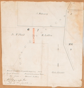
Map, Land required for a public highway near Rowsley, Victoria. Circa 1880s
This map indicates portions of land in the Parish of Gorrockburkchap near Rowsley which was required for construction of a road. The land required was leased to a Michael Laffan. Other blocks of land nearby owned or leased by D. McPhail and J. Mahoney are also indicated on the map. The date of the map is not known. However newspaper reports in the Bacchus Marsh Express on the 18 March 1882, page 3, column 3 mention land occupied by McPhail and Laffan near Rowsley in connection to the construction of a public road.Single page map showing land occupied by farmers D. McPhail and Michael Laffan which was required for a public highway. Scale 6 chains to inch. Part of a set of maps which are pasted into a bound volume containing 76 maps or plans in total. High resolution digital image stored on BMDHS computer network. Signed by Shire Engineer, W.E. Standfieldrowsley victoria maps -
 Whitehorse Historical Society Inc.
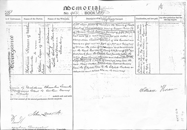
Legal record - Land Title, Land Memorial, 1860
Land Memorial No 963, Book 377, relating to transfer of land in Metropolitan Avenue, Nunawading from William Horan to William Loganhoran, william, logan, metropolitan avenue, nunawading, land sales -
 Whitehorse Historical Society Inc.
Legal record - Land Title, Land Purchase, 2/02/1858
Photocopy of agreement for land purchase by auction held on 2 February 1858.Photocopy of agreement for land purchase by auction held on 2 February 1858. Purchase by Nelson Polak of land adjacent to Dandenong Creek.Photocopy of agreement for land purchase by auction held on 2 February 1858. polak, nelson, dandenong creek, land sales