Showing 1642 items
matching 1791-1866.
-
 Hume City Civic Collection
Photograph
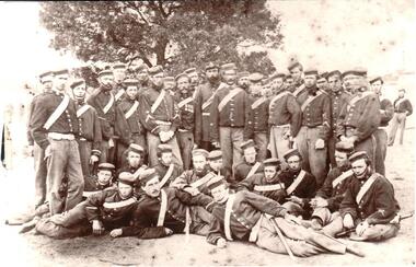
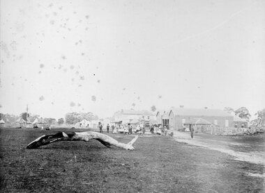
In 1866 the North Melbourne Company RVV Infantry were camped at the escarpment in the grounds of Rupertswood.A sepia photograph of the North Melbourne Company at an 1866 camp RVV Infantry. 13 men are sitting on the ground in front and there are 25 men standing behind them. Two men are in the background at the right and one man at the left. The group are standing in front of a tree.written on back: N. MELB. COY. R.V.V. INF. 1866 SUNBURY CAMP N. MELB. RCA 63sunbury camp, sunbury escarpment, north melbourne company, armed forces, men, clothing and dress, rupertswood, 1860s, george evans collection -
 Stawell Historical Society Inc
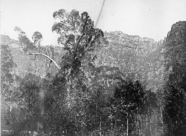
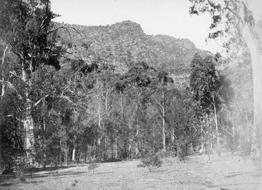
Photograph, Wonderland Range in the Grampians 1866
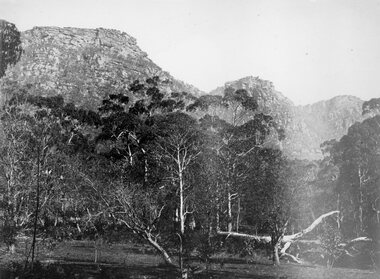
Grampians (Wonderland Range). Part of a collection of Photographs by Mr. O.G. Armstrong as commissioned by the Shire of Stawell for the Inter-colonial and Paris Exhibition in Melbourne in 1866. The Grampians, with its wildflowers and rock formations, have attracted people from all parts of the world for many years and have always been promoted strongly by local groups. One such group was the Grampians Tourist Association, formed in 1901. Wonderland would probably be the best known part of the whole area, noted for its rugged and weather worn rock formations and spectacular views, too numerous to mention. The Grampians are now a National Park. stawell -
 Stawell Historical Society Inc
Photograph, Court House and Cells Pleasant Creek Stawell 1866
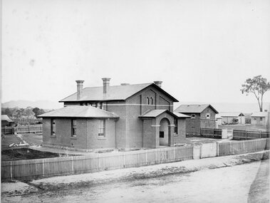
Court House and Cells Pleasant Creek Stawell. Part of a collection of Photographs by Mr. O.G. Armstrong as commissioned by the Shire of Stawell for the Inter-colonial and Paris Exhibition in Melbourne in 1866. The first courthouse was built at Pleasant Creek Stawell by William Scobie for the sum of £1975 in September 1858. A further sum of £1832 was spent on the building by J. Francis in January 1860. Pleasant Creek Court House was used as a court of Petty sessions, County Court, Court of Mines, and a Court of General Sessions before the newer Stawell Court House in Patrick Street was built. Later it was used as a police barracks then private home. stawell government -
 City of Greater Bendigo - Civic Collection
Sign - Shire of Strathfieldsaye Coat of Arms
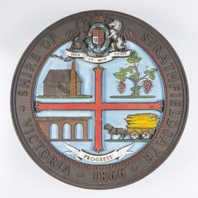
The district of Strathfieldsaye was proclaimed in 1861 and named a Shire on the 17th September in 1866. It remained a shire until amalgamation in 1994 when it became part of the City of Greater Bendigo. The shire was located 8 km to the south- east of Bendigo and covered an area of 601 square kilometres and extended from the Calder Highway to the Coliban and Campaspe Rivers. The shire's administration centre was in Strathfieldsaye until 1972 when new offices were opened in Kennington. This coat of arms was commissioned for the front of the shire hall building.Brass painted coat of arms or emblem within a circle of the Shire of Strathfieldsaye. Outer rim contains text: SHIRE OF STRATHFIELDSAYE VICTORIA 1866 with the shield of the monarch of the United Kingdom centre top. The shield is divided into four parts with images reflecting the leading industries of the time; wine growing, mining, farming and tanning. The motto PROGRESS is depicted lower centre of shield. SHIRE OF STRATHFIELDSAYE / VICTORIA / 1866 / PROGRESSshire of strathfieldsaye, city of greater bendigo amalgamation, city of greater bendigo signs -
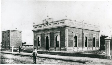 Stawell Historical Society Inc
Photograph, Stawell Shire Hall 1866
This photograph is a copy obtained from State Library of Victoria. The photograph is of Stawell Shire Hall. Two persons can be seen in the foreground. The two story brick building beside the Stawell Shire Hall was once the Literary Institute. The Stawell Shire Hall building has been added to over the years. Ronald Campbell, the Shires second president laid the foundation stone on 28th April. 1866. The contractors were Hutchings and Delbridge. The photograph shows the first hall and office. The building contained simple 18 feet square rooms, with an entrance hall separating them, the facade was almost as it is now. The initial cost of the Shire Hall was $502.Black and white photograph of Stawell Shire Hall as one single storey brick building with parapet on top. Beside the Shire Hall is a two storey brick building. Also, a dwelling between the two building in the background in Cooper St. Two persons in the foreground, one on the road the other on the pathway. stawell -
 Stawell Historical Society Inc
Photograph, "Barney’s Castle" in the Grampians at Halls Gap 1866
Grampians Halls Gap (Barney’s Castle). Part of a collection of Photographs by Mr. O.G. Armstrong as commissioned by the Shire of Stawell for the Inter-colonial and Paris Exhibition in Melbourne in 1866. In 1880 a branch line from Stawell Railway Yards was built to Heatherly Quarry, to carry stone for part of Parliament House Melbourne, the GPO in Elizabeth St, the Harbour Trust buildings, additions to the Melbourne Town Hall, the Stawell Courthouse Patrick Street and the Stawell Catholic Church in Patrick St. The line was taken over by the Railways Department in June 1905 and was closed in March 1949. It has since been removed but remnants of the machinery and buildings are visible at the quarry site. stawell -
 Stawell Historical Society Inc
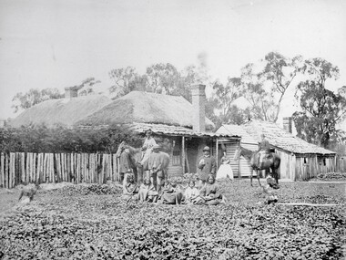
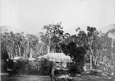
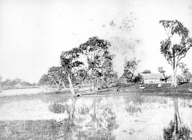
Photograph, Swinton Family Home Station in Glenorchy 1866
Swinton Home Station. Part of a collection of Photographs by Mr. O.G. Armstrong as commissioned by the Shire of Stawell for the Inter-colonial and Paris Exhibition in Melbourne in 1866. Swinton was a family name of John Carfrae, whose father was Thomas Swinton Carfrae of Edinburgh. When John Carfrae came to Ledcourt in 1848 he divided it into three runs, Ledcourt, Swinton and Newington. John Holt occupied Ledcourt and Swindon before 1865, at which time Marcus Clarke was a jackaroo. Alexander Gray came to Swinton in 1881. The Grey family still live at Swinton. The present home was built in 1911 after severe floods in 1909 destroyed the original homestead. Wooden cottage with outbuildings in front of trees. A number of men women and First Nations people standing and sitting in front.stawell aborigional -
 Stawell Historical Society Inc
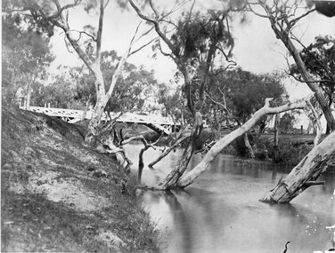
Photograph, Glenorchy Bridge on the Wimmera River 1866
Glenorchy Bridge Wimmera River. Part of a collection of Photographs by Mr. O.G. Armstrong as commissioned by the Shire of Stawell for the Inter-colonial and Paris Exhibition in Melbourne in 1866. Prior to the construction of this bridge in 1860, there existed two forwards across the Wimmer River at Glenorchy. One was 2 miles on the Stawell side of Glenorchy and 500 metres from the present railway bridge. It was well made, stone floor and can be seen today. The second was located 800 metres downstream of the town and was known as Stuart’s Crossing. These Fords were popular crossing spots for Bullock Drays which were delayed for days during floods before the bridge was built. The original Bridge was built near the site of the present ‘old’ bridge. stawell -
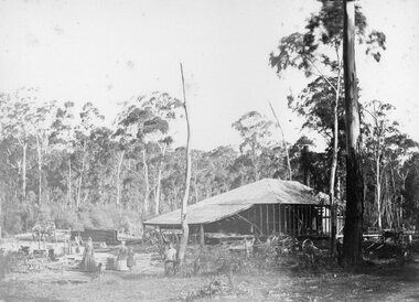 Stawell Historical Society Inc
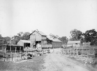
Photograph, Saw Mills at Childe’s Glenbower Creek in Halls Gap 1866
Saw Mills Halls Gap (Childe’s Glenbower Creek). Part of a collection of Photographs by Mr. O.G. Armstrong as commissioned by the Shire of Stawell for the Inter-colonial and Paris Exhibition in Melbourne in 1866. During the years of gold, the hardwood forests around Stawell were ravaged to provide timber for the mines. It was used undergrounds to shore up workings, and millions of feet of it were fed into furnaces and kilns in which the quartz was roasted. In the years after the gold boom, hardwood from the Grampians was milled for building timber. Wherever there are large tracts of natural bushland, fires are always a danger. A huge fire in January 1939 caused havoc in the Grampians, burning out towns and sawmills such as the one pictured. There have been no sawmills in the Grampian since that fire. stawell industry -
 Stawell Historical Society Inc
Photograph, Grampians Sunrise over the Saw Mills 1866
Grampians (Sunrise over the Saw Mills). Part of a collection of Photographs by Mr. O.G. Armstrong as commissioned by the Shire of Stawell for the Inter-colonial and Paris Exhibition in Melbourne in 1866. The Grampians were first sighted by Major Thomas Mitchell on the 11th of July 1836. Four days later he and a small party climbed its highest peak and named it Mount William. Owing to the lateness of arrival at the summit they had to spend a very cold and miserable night. Whilst in the Grampians, which he so named because of their likeness to his native Scotland. He collected about 150 plants and sent them to the Professor of Botany, John Lindley at the University of London. It is now known there about 900 different flowering plants in the Grampians, over one third of all those growing in Victoria. stawell industry -
 Stawell Historical Society Inc
Photograph, Great Western 1866
Great Western. Part of a collection of Photographs by Mr. O.G. Armstrong as commissioned by the Shire of Stawell for the Inter-colonial and Paris Exhibition in Melbourne in 1866. Great Western began as a changing station on Concongella, northeast of the present Township. The gold rush in Great Western began in 1858 and soon after a post office and store opened. A Township was surveyed and lots sold in October 1858. The gold soon passed and the diggers went on, leaving a small settlement. In 1863 Jean Pierre Trouette and Emile Bampied, his brother-in-law, planted the first vines and build the first winery, thus setting a firm foundation upon which the present wine industry has been built. Telegraph poles and wires visible. Bakery visible in distance on right of road, looking west. stawell -
 Stawell Historical Society Inc
Photograph, Grampians at Halls Gap 1866
Grampians Halls Gap. Part of a collection of Photographs by Mr. O.G. Armstrong as commissioned by the Shire of Stawell for the Inter-colonial and Paris Exhibition in Melbourne in 1866. From about 1860 there was agitation for a water supply, not only for Stawell but for the Wimmer Mallee as well. In 1887 Wartook was adopted as the first reservoir for the Wimmer. Stawells water supply was designed by Mr. John D’Alton. The scheme came from Fyan’s Creek via Wooden Fluming and a Syphon and finally through the mountain in a tunnel, before being piped to a reservoir on Big Hill. The system was completed in December 1881 and although there have been modifications, basically it has not been changed to this day. The Wimmera Mallee stock and domestic system from the Grampians is the largest system of its kind in the world, the latest edition being like Belfield and piping of Wimmera channels. stawell -
 Stawell Historical Society Inc
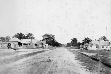
Photograph, Glenorchy 1866
Glenorchy. Part of a collection of Photographs by Mr. O.G. Armstrong as commissioned by the Shire of Stawell for the Inter-colonial and Paris Exhibition in Melbourne in 1866. Glenorchy township began as a resting place for bullock teams and travellers in the 1840s. In 1847, John Gleeson built the Four Posts Inn, which then became the name of the settlement. Gleeson is credited with naming the settlement Glenorchy, meaning tumbling waters, after his birth place in Scotland. In 1865 the Township consisted of a church, school, three hotels the Four Post Inn built 1847, Royal Hotel built 1855, The Royal Mail Hotel built1862. As well as boot makers, a blacksmith, stores, butcher and other enterprises. The town was a postal centre served by three coaches each day until the advent of the railway. stawell -
 Stawell Historical Society Inc
Photograph, Fountain Head Brewery at Armstrong 1866
Fountain Head Brewery Armstrong's. Part of a collection of Photographs by Mr. O.G. Armstrong as commissioned by the Shire of Stawell for the Inter-colonial and Paris Exhibition in Melbourne in 1866. The brewery, a three-storey high building, was established close to two streams which joined the Concongella Creek near Armstrong, although the water required to run the brewery was obtained from a natural underground spring which is still visible. Further findings of Gold in Victoria around 1859-1860 brought a large rush of miners to the area. Some stayed on to become merchants, farmers, etc. Jens Kofoed, a shipwright from the Netherlands, was one who came to the area at this time. He and his family move to Armstrong in 1860, establishing the Fountain Head Brewery, which employed quite a number of people for about 40 years. stawell industry -
 Stawell Historical Society Inc
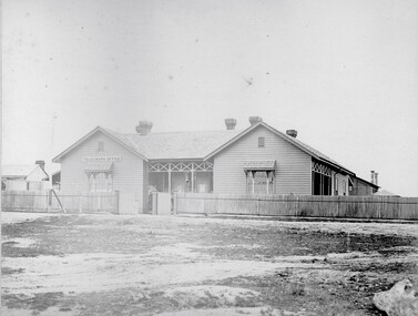
Photograph, Telegraph Office Pleasant Creek Stawell 1866
Telegraph Office Pleasant Creek Stawell. Part of a collection of Photographs by Mr. O.G. Armstrong as commissioned by the Shire of Stawell for the Inter-colonial and Paris Exhibition in Melbourne in 1866. The first post was office was erected at Commercial Street, Pleasant Creek in the goldfields, in June 1858, by J Harding and was a portable one. In October 1860 the first permanent Telegraph Office was erected by Cormick and Irvine for £329. In the same month the Post Office was removed from Commercial St in the Goldfields to the rear of the Telegraph office in Stawell. In February 1862 Edmond Johnson was appointed manager of Electrical Telegraph, Collector of Imposts and acting Postmaster. This building was later used as a private dwelling. It is situated in Lesley Street at the rear of the Pleasant Creek Courthouse although the right-hand wing has been removed. stawell -
 Stawell Historical Society Inc
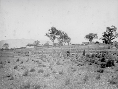
Photograph, Concongella Home Station 1866
Concongella Home Station. Part of a collection of Photographs by Mr. O.G. Armstrong as commissioned by the Shire of Stawell for the Inter-colonial and Paris Exhibition in Melbourne in 1866. The Concongella Station consisted of 57,000 acres along the Concongella Creek. It was first part of Allanvale, taken up by John Allan in 1841. Allen's right to the 137,000 acres of Allanvale was contested and as a result, the northern section of 57,000 acres was renamed Concongella. Concongella Run, with the homestead on the creek of the same name just east of Stawell, occupied the lands between the later named Deep Lead and Great Western. It was on this station that William McLaughlin a sheep minder discovered gold at Pleasant Creek in 1853. Doctor Blundell held Concongella under licence at this time and through until 1858. The homestead has been gone for many years and only some lonely graves remain at this vicinity. stawell -
 Stawell Historical Society Inc
Photograph, "Schoolers" Homestead at Lake Lonsdale 1866
Schoolers Homestead Lake Lonsdale. Part of a collection of Photographs by Mr. O.G. Armstrong as commissioned by the Shire of Stawell for the Inter-colonial and Paris Exhibition in Melbourne in 1866. Similar Photo Scoullar station Rosehill Cat No 3888 G.F. Scoullar originally from Canada, according to W.G. Sharply in his 1930 Stawell Borough History, was a member of the Stawell Shire Council 1870-1888 and president 1875-1876. Maynard Ord in Stawell Past and Present says G.F. Scoullar, M. Brinkman and one other, took up small pieces of land fronting Lake Lonsdale. The owners of the Squatting Run, presumably Ledcourt, charged them with illegal occupation. They were heavily fined at Pleasant Creek Court, or in default gaol. As they could not afford the fine, some friends raise the money. Note re the spelling of ‘Schooler’. Variations in local records are ‘Schoullar’ and ‘Scoullar’. stawell education -
 Stawell Historical Society Inc
Photograph, Ledcourt Home Station in the Grampians 1866
Ledcourt Home Station Grampians. Part of a collection of Photographs by Mr. O.G. Armstrong as commissioned by the Shire of Stawell for the Inter-colonial and Paris Exhibition in Melbourne in 1866. This was one of, if not the first, Squatters Sheep Station in this region. The first licence of Ledcourt was granted to Robert Briggs in about 1840. In 1842 the run passed to Benjamin Boyd of Whaling and Boydtown Banking fame in NSW. He held it for six years. It was then taken over by Thomas Young and John Carfrae, who divided it into 3 holdings. Ledcourt 74,500 acres, Newington 74,500 acres and Swinton, 52,000 acres. It again changed hands in 1859, this time to Henry Alfred and Joseph De Little. It has changed hands several times since and in later years owned by the Cooper family and now the Marr family. The date of the actual building is uncertain, but it is known that the stone used in the building was carted from the Mount Difficult area in the Grampians and some of the courtyard paving shows convict origin. Looking up hill with Homestead on left and stone stables or right.stawell -
 City of Greater Bendigo - Civic Collection
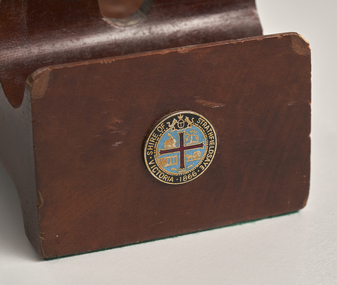
Ceremonial object - Shire of Strathfieldsaye Gavel and Stand, Unknown
This gavel (or mallet) and stand was used by the Shire of Strathfieldsaye Mayor or a presiding officer of a meeting to signal for attention or order.Wooden gavel with carved handle and stand. Front of stand has enameled circular badge containing the Shire of Strathfieldsaye coat of arms with words Shire of Strathfieldsaye Victoria 1866.Shire of Strathfieldsaye Victoria 1866.shire of strathfieldsaye, city of greater bendigo administration item -
 Stawell Historical Society Inc
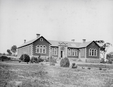
Photograph, Pleasant Creek Hospital 1866
Pleasant Creek Hospital. Part of a collection of Photographs by Mr. O.G. Armstrong as commissioned by the Shire of Stawell for the Inter-colonial and Paris Exhibition in Melbourne in 1866. Due to a public outcry for medical services on the goldfield a public meeting was held in the Olympic Theatre at Deep Lead on the 7th of August 1858. It appointed a 50 man committee to establish a hospital at Pleasant Creek. A temporary Tent structure was soon erected at Doctors Hill, situated midway between Deep Lead and Commercial Street Pleasant Creek, just South of the later Western Highway. The site is now marked by a commemorative stone. Within two months the committee had collected £600 in subscriptions, a government Grant for £2500 and acquired 10 acres of land. The foundation stone of the hospital building was laid on 21st December 1860 and the building completed and occupied by 21st June 1861. In the 1930’s the hospital moved to the centre of Stawell in Sloane Street and the buildings then taken over by the Pleasant Creek Training Centre. Brick hospital building with two ward wings and central front door. Man standing on steps.stawell health -
 Stawell Historical Society Inc
Photograph, Stawell Shire Hall 1866 -- 04 Photos -- Coloured
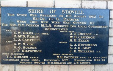
Shire Hall 4 Colour photos. Three photos (84.10a, b, c,) showing the brick veneer addition to the Stawell Shire Hall. One photo (84.10) of the plaque bearing the councillors names. These photos were taken in 2013 and each photo shows a different view of the brick veneer addition. One view is the front of the brick addition and other 2 are of the rear view of the 1962 addition.Four colour Photographs. Three of the brick additions to the Stawell Shire Hall in 1960-1962. One photograph of the plaque bearing the councillors names.Shire of Stawell. This stone was unveiled on 8th August 1962 by Ex. Cr. C. S. Reading When this new wing was opened by the Hon. M.V. Porter M.L.A. Minster for Local Government. Councillors WEST - E. W. Giles J.P. Pres., R. McD. Perry., L. J. Campbell., EAST - G. W. N. Cox., A. G. Holden., I.F. Kilpatrick., NORTH EAST - A. E. Duxson J.P., W.B. Cameron., A.H. Ellen., NORTH - C.J. Hutchings., A. J. H. Gray., J. R. Williams J.P., Shire secretary V. C. Neilson F.I.M.A. Shire Engineer N. H. Cottman B.C.E. C.E. A.M.I.E (Aust) Originally Built 1866. Extended 1873. Remodelled 1960-62 Builders 1960-62 W.R. Willcock and J.W. Kennedy.stawell -
 Stawell Historical Society Inc
Photograph, "Allanvale" Home Station in Great Western 1866
Allanvale Home Station. Part of a collection of Photographs by Mr. O.G. Armstrong as commissioned by the Shire of Stawell for the Inter-colonial and Paris Exhibition in Melbourne in 1866. Allanvale was taken up about 1841 by John Allen, who was the son of George Allan of Allanvale, near Launceston in Van Diemen's Land. He selected 80,000 acres between present day Stawell and Ararat. The property was gradually reduced in size, with the first split occurring in the 1840s with the annexation of Concongella Selection due to a land dispute. J.S. Davidson was the occupier of Allanvale at the time this photograph was taken. The homestead pictured here was destroyed by fire at the end of the First World War and replaced by a new building around 1923. The present owners of Allanvale are the Kilpatrick family A note on the Allan family. On the 15th of March 1845, John Allen's 26 year old wife died at the birth of their third child, a daughter, who also died several weeks later. Elizabeth Allen had been a dear friend of Mrs Horatio Wills of neighbouring Lexington station. Eliza and her daughter were buried side by side in the garden of Lexington homestead. She was said to have been the first white woman to have died in the district. Homestead and stables on left with people on verandah and orchard in foreground.stawell great western -
 Tarnagulla History Archive
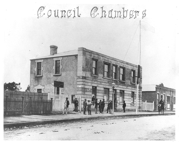
Photograph of Tarnagulla Council Chambers, June 1866
Murray Comrie Collection. Copy of an 1866 photograph by Aimé Marchand. The building was originally Company's Hotel, then used as temporary premises by the Colonial Bank during construction of the bank's own premises, then Borough of Tarnagulla Council Chambers and Mechanics Institute. Also known locally as Burstall Hall from c1960 following a donation of maintenance funding from the Estate of the late RH Burstall. In June 1866, Aimé Marchand (1846-1910) made a series of fourteen photographs which were submitted to the 1866-67 Melbourne Intercolonial Exhibition, where they earned a 1st Class Honorable Mention. This is one of those fourteen images. Of French or Belgian origin and possibly formerly an assayer in California, Marchand appears to have begun his practice of photography in Tarnagulla around 1865 as an assistant to A.B. Clay. By the following year he had settled in Portland, where he opened the Royal Photographic Studio in Gawler Street. From his base in Portland he toured surrounding districts, offering portrait and view services. Little else is known about his life. He appears to have left Australia in 1878. A misprint of his name in a local directory as Annie Marchand created the misconception that he was one of only a few named women photographers in the colonies. Monochrome photograph the Tarnagulla Council Chambers in June 1866. tarnagulla, views, burstall hall, council chambers, local government, commercial road, local people, residents, aimé marchand, photographers -
 Tarnagulla History Archive
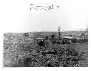
Photograph: View of Tarnagulla, June 1866
Murray Comrie Collection. In June 1866, Aimé Marchand (1846-1910) made a series of fourteen photographs which were submitted to the 1866-67 Melbourne Intercolonial Exhibition, where they earned a 1st Class Honorable Mention. This is one of those fourteen images. Of French or Belgian origin and possibly formerly an assayer in California, Marchand appears to have begun his practice of photography in Tarnagulla around 1865 as an assistant to A.B. Clay. By the following year he had settled in Portland, where he opened the Royal Photographic Studio in Gawler Street. From his base in Portland he toured surrounding districts, offering portrait and view services. Little else is known about his life. He appears to have left Australia in 1878. A misprint of his name in a local directory as Annie Marchand created the misconception that he was one of only a few named women photographers in the colonies. Monochrome photograph depicting a view across Tarnagulla in June 1866.tarnagulla, views, mining, aimé marchand, photographers -
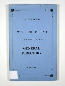 Marysville & District Historical Society
Book, Butler's Wood's Point and Gipps Land General Directory 1866, 1985
A directory of the local businesses, road guides and table of distances in the Wood's Point, Jamieson, Omeo and Bairnsdale areasHardback. Blue dust cover. Title in black on the front cover.Stamp of the Marysville & District / Historical Society Inc / P.O. Box 22 / Marysville 3779directory, wood's point, gippsland, victoria, history, jamieson, bairnsdale, omeo, road guide, table of distances, advertisements -
 Glenelg Shire Council Cultural Collection
Book, Victorian Government Gazette 2, 1866. 1 July - 31 December, 1867
Dark blue marbled cloth over hard cardboard. Red leather spine and corners. Gold lettering on black band on spine. Gold crown and lettering on spine.local courts, local government, government administration, gazette, victorian government -
Glenelg Shire Council Cultural Collection
Book, Victorian Government Gazette 2, 1866. 1 July - 31 December, 1867
Green marbled fabric over hard cardboard. Red leather spine and corners. Gold lettering on black band on spine. Gold crown and lettering on spine.local courts, victorian government, government administration, gazette -
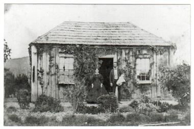 Yarra Glen & District Historical Society
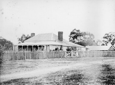
Black and white photographs, House and post office owned by John Hicks Petty 1866
Built in 1861 on the south side of Symonds Street opposite Irvine Crescent this building was the home of John Hicks Petty. He operated the first Post Office in Yarra Flats from here. Mr Petty, holding a baby, is standing alongside his wife Maria Louisa Petty. The cottage is built of sawn timber, placed vertically, and a shingle roof. There is an established garden surrounding the house with creeper climbing the walls.post office, original post office, john hicks petty, maria louisa petty, symonds street, irvine crescent, shingle roof, timber house, cottage garden, baby, yarra flats post office, yarra flats -
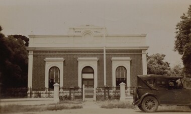 Stawell Historical Society Inc
Photograph, Stawell Shire Hall 1866 in Longford Street c 1920
Front view of Stawell Shire Hall in Longford Street with wrought iron fence and 1920's motor vehicle parked outside. The photograph taken in 1949 was donated by Mr. F. M. Mortyn who was Secretary of the Stawell Shire from 1947 - 1960. A small black & white photo of the Stawell Shire Hall with its brick facade with a parapet top. The entrance doorway in the centre with windows each side. In front a wrought iron fence. The gate of the fence is painted white. A 1920's motor vehicle is parked out the front to the right of the Shire Hall. Stawell Shire Hall 1949.stawell -
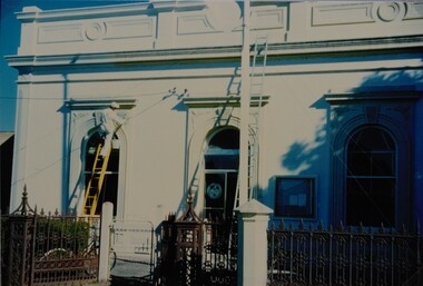 Stawell Historical Society Inc
Photograph, Stawell Shire Hall 1866 -- Coloured
Stawell Shire Hall in the process of being painted. The photo shows the painter up the ladder with a paint bucket. A bicycle is leaning against the decorative fence possible the painters bike.Coloured photograph of the Stawell Shire Hall being painted. A person in white overalls is standing on the top rails of the ladder painting the decorative window out the front. A taller ladder is positioned near the door and leaning against the parapet. The photo also shows the decorative fence, with a white post and white gate. Peterboro Cardboards The Canadian Board/Le Carton Canadian No. 337stawell