Showing 610 items
matching boundary road
-
 Bayside Gallery - Bayside City Council Art & Heritage Collection
Map, H.B. Foot, Plan of the Brighton Estate containing 5120 acres, first special survey at Port Phillip, c. 1842
... miles south from Melbourne, bounded by North Road, East Boundary... by North Road, South Road and East Boundary Road. The plan shows... Melbourne, bounded by North Road, East Boundary Road, South Road ...This plan records the Brighton Estate, also known as Dendy's Special Survey. In 1840 Henry Dendy, a farmer in Surrey, England acquired a "Special Survey" from the Commissioners for Land and Emigration which gave him the right to choose land in Port Phillip for the low price of £1 per acre for 5120 acres. Dendy appointed Jonathan Binns Were, as his agent, who later became a partner. Together, Dendy and Were decided on an area 5 miles south from Melbourne, bounded by North Road, East Boundary Road, South Road and to the west by Port Phillip Bay. Their Brighton Estate was first surveyed by T. S. Townsend in May 1841 and was re-surveyed by Robert Hoddle. Dendy and Were were making plans to sell the land and advertised a 30-guinea prize for the best subdivision which was to be divided into a village, marine residences, suburban and cultivation allotments, with the remainder being divided into country sections. The competition was won by H.B. Foot, who planned the village around a reserve and crescents and a 'green belt' forming the town boundary. brighton estate, dendy's special survey, special survey, henry dendy, jonathan binns were, w.b. were, survey, plan, map, brighton, george ward cole, baker's lithographer, hibernian, subdivision, town planning, cartographic material, h.b. foot -
 City of Kingston
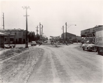
Photograph - Black and white, c. 1956
... and East Boundary roads, Bentleigh East. Several cars are visible... of the intersection of Centre and East Boundary roads, Bentleigh East. Several ...Strip shopping and ample parking were features of suburbs in the middle of the twentieth centuries. Cars were still considered a luxury, although that would soon change, and local, independent shops serviced local areas.During the post-war years, the municipality of Moorabbin experienced a population boom. The 'newcomers' were predominantly returnees from the war who were marrying and establishing families; those from the old inner-suburban areas who were moving away from rented premises to establish their own homes on cheap land. The 1950s were a time of immense growth for the area now known as City of Kingston.Black and white photograph of the intersection of Centre and East Boundary roads, Bentleigh East. Several cars are visible both in the foreground and background, and the intersection includes a roundabout. The street is lined with poles to carry electricity cables, and the roundabout is dotted with four poles for electric street lights.Handwritten in blue ink: 56 - 230 Handwritten in red ink: 82% Handwritten in black ink: Ch. 6shopping strip, cars, suburbs -
 Ballarat Tramway Museum
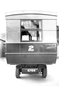
Photograph - Geelong Tramways MESCo bus No. 2
... route between the East terminus at Boundary Road and the railway... route between the East terminus at Boundary Road and the railway ...Rear of MESCo's bus No. 2, built for their East Geelong route between the East terminus at Boundary Road and the railway station or Moorabol St. wharf. Note the twin rear tyres. Looks new, 1912.Black and white print on paper.No. 1 inside a circle written on the reverse in pen. 14-2 and GRS710/14/1/2 written n the reverse in pencil.geelong tramways, mesco bus no. 2 -
 City of Kingston
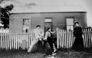
Photograph - Black and white, c. 1910
... The cottage was located on East Boundary Road, near Caleb... Parkdale The cottage was located on East Boundary Road, near Caleb ...The cottage was located on East Boundary Road, near Caleb Street in East Bentleigh. It was owned by Caleb Porter and occupied by Laura Johnson (centre). Also in the photograph are her sister Boletta Hansen Wold (left) and daughter Anna Marie Johnson (right). The dog's name has not been recordedPart of East Bentleigh was inside the original grant of land bought by English farmer and brewer, Henry Dendy, in 1841. He bought 5,120 acres (20.7 km2) which was bounded on the west by Port Phillip Bay, then North Road, East Boundary Road and South Road.Black and white image of three women and a dog standing outside a small weatherboard cottage with a picket fence. Round white sticker with black printed text: 140 Handwritten in red ink: 55%east bentleigh, caleb porter, laura johnson, boletta hansen wold, anna marie johnson -
 City of Moorabbin Historical Society (Operating the Box Cottage Museum)
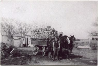
Photograph, Black & White, V Peterson East Boundary Rd East Bentleigh loaded wagon c1900, original c1900
... and established a market garden in East Boundary Road East Bentleigh. Vic... and established a market garden in East Boundary Road East Bentleigh. Vic ...The Peterson family were early settlers in Moorabbin Shire and established a market garden in East Boundary Road East Bentleigh. Vic Peterson and family loaded the crop - cabbages - onto the horse drawn wagon and set off to the Melbourne market using the Plateways that ran along Centre Road and Nepean Highway. The early settlers like the Petersons , in the Parish of Moorabbin County of Bourke after Henry Dendy's Special Survey Brighton 1841, established market gardens, fruit & flower gardens, poultry & dairy farms, vineyards as well as shop businesses, blacksmiths, chemists, nursing homes and schools & Churches.Black & White photograph showing Vic Peterson beside the horse drawn wagon loaded with 35dozen ( 12x 35) cabbages setting off to market c 1900 Original re-digitised by H Stanley 2005Back Hand written informationwagons, vulcan trucks, draught horses,, peterson vic, marriott dick, cabbage crops, vegetable crops, poliomyelitis epidemics 20thc , elster creek, plateways moorabbin shire, smith j l; smith mary ann, stanley helen, smith vic, smith harry redvers, chaff cutter, horse drawn carts, toll gates brighton, motor cars 1900, steam engines, early settlers, bentleigh, mckinnon, parish of moorabbin, city of moorabbin, county of bourke, moorabbin roads board, shire of moorabbin, henry dendy's special survey 1841, were j.b.; bent thomas, o'shannassy john, king richard, charman stephen, highett william, ormond francis, maynard dennis, market gardeners, vineyards, orchards -
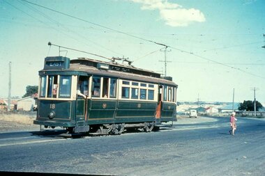 Ballarat Tramway Museum
Slide - 35mm slide/s, mid 1950's
... Pengelley No. 18 at East Terminus Ormond and Boundary Roads. Photo... and Boundary Roads. Photo shows a child walking away from the tram ...Yields information about the Geelong tramway system and one of the terminus and the appearance at the time.Agfachrome Professional plastic mount (blue base, white cover) reproduction slide of a colour slide of Geelong Pengelley No. 18 at East Terminus Ormond and Boundary Roads. Photo shows a child walking away from the tram. Tram has the destination of East. Photographer unknown. Taken on the last day of the first closures, 8/1/1956. See also Reg Item 4389 for a print of this slide. "G 16" and "1 -16" in pencil.tramways, trams, geelong, east, closure, last day, tram 18 -
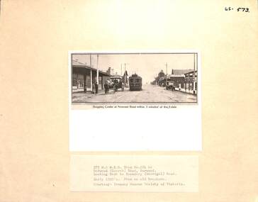 Melbourne Tram Museum
Photograph - Block Mounted Photograph, Surrey Hill Neighbourhood Centre, c1920
... , or Norwood terminus in Toorak Road, at Boundary Road. Copied from... at the Burwood Road, or Norwood terminus in Toorak Road, at Boundary Road ...Photograph - mounted onto a heavy card, numbered 65-573 in the top right hand corner of MTTB No. 124 at the Burwood Road, or Norwood terminus in Toorak Road, at Boundary Road. Copied from a Real Estate brochure. Photo courtesy of the TMSV. Photo shows a number of shops or stores, including a Tea Merchant and the single line tramway on the south side of the roadway. See image i2 for a scan of the photograph.On rear in ink "Copied for Keith Kings 2002: and the "Surrey Hill Neighbourhood Centre" stamp.trams, tramways, burwood, toorak road, tram 124 -
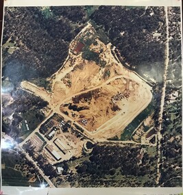
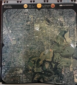
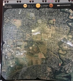 Greensborough Historical Society
Aerial Photograph, AAM Photographics, Heidelberg AAM1969c 086, 24/11/1991
... Yallambie Road; West boundary Hurstbridge railway.... & Yallambie. North boundary Yallambie Road; West boundary Hurstbridge ...One of a series of four overlapping aerial photographs of the Heidelberg/Greensborough areas in 1991, covering Simpson Barracks, Macleod, Rosanna, Viewbank, Watsonia & Yallambie. North boundary Yallambie Road; West boundary Hurstbridge railway.Laminated colour aerial photographssimpson barracks, yallambie, watsonia, macleod, rosanna, viewbank -
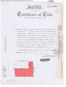
 Greensborough Historical Society
Certificate of Title, Supreme Court of Victoria (Probate Division) et al, Certificate of Title Vol. 2567 Fol. 294, Vol. 3134 Fol. 605, 22/05/1895
... Road (now Grimshaw Street), Southern boundary Nell Street... Greensborough Road (now Grimshaw Street), Southern boundary Nell Street ...Title Vol. 2567 Fol. 294 in the name of The Greensborough Estate Company Limited, 164 acres four and a half perches, being part of Crown Portion 17 Parish of Keelbundora, County of Bourke. Dated 22nd May 1895. Northern boundary Greensborough Road (now Grimshaw Street), Southern boundary Nell Street, Eastern boundary Plenty River, Western boundary road (now named McDowell Street); Title Vol. 3134 Fol. 605 in the name of Adolphe Frederic Seelenmeyer, land as described above, LP 4759 and transfers and other instruments to 9 March 1948Folder containing two Certificates of Title (3p. + 9 p.) and twenty pages of miscellaneous documents, including historical summary, brief biography of A. F. Seelenmeyer, two Death Certificates and photocopied extracts from probate documents, as listed in table of contents, ed. by Peter Simmenauergreensborough, greensborough estate company limited, grimshaw street greensborough, plenty river, nell street greensborough, mcdowell street greensborough, adolphe frederic seeley, formerly seelenmeyer, adolfe frederic seelenmeyer -
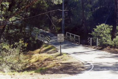 Whitehorse Historical Society Inc.
Photograph, Quarry Road Bridge, Mitcham, 2007
... boundary of Whitehorse Road and Manningham Municipalities. (See... of Quarry Road Bridge, Mitcham near boundary of Whitehorse Road ...Coloured Photo of Quarry Road Bridge, Mitcham near boundary of Whitehorse Road and Manningham Municipalities. (See record number NP3411 above)quarry road, mitcham, bridges -
 Greensborough Historical Society
Aerial Photograph, AAM Photographics, Heidelberg AAM1969c 088, 24/11/1991
... , South boundary Ivanhoe East, East boundary Bulleen Road...Greensborough Historical Society 34A Glenauburn Road Lower ...One of a series of overlapping aerial photographs of the Heidelberg/Greensborough area, covering Eaglemont, Heidelberg, Ivanhoe East & Viewbank. North boundary Hurstbridge railway, South boundary Ivanhoe East, East boundary Bulleen RoadLaminated colour aerial photographeaglemont, heidelberg, ivanhoe east, viewbank -
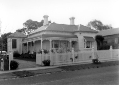 Surrey Hills Historical Society Collection
Photograph, 'Garmure', 26 Russell Street, Surrey Hills in 1988
... brother and mother were living in Boundary Road. She is buried..., her brother and mother were living in Boundary Road. She ...‘Garmure’, 26 Russell Street, Surrey Hills was built c. 1887 and renovated c1988. This photo was taken after renovation of the rear of the house when the corner tower was added. Occupants: 1890: Mr Caffin 1910: Miss Agnes Campbell Hutchinson Orr 1930 – 1988: Sextons Miss Orr was born in Hutchesontown, Glasgow to Francis Orr (1834-1859) and Jane McDonald. Her father died soon after her birth and her mother married Thomas Blood. She had a half-brother Robert McDonald Blood. In 1903 she, her brother and mother were living in Boundary Road. She is buried with them in Kew Cemetery. She died aged 57 on 1 December 1926. A black and white photograph of a Queen Anne Style weatherboard house with a return veranda. The roof is corrugated iron. There is a picket fence along the front and a driveway on the left had side of the building.garmure, house names, (mr) - caffin, sexton family, queen anne style, corrugated iron, weatherboard, russell street, surrey hills, (miss) agnes campbell hutchinson orr -
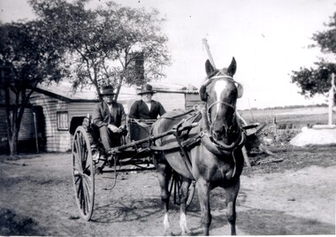 City of Kingston
Photograph - Black and white, c. 1920
... was between East Boundary and Brady Road, East Bentleigh.... was between East Boundary and Brady Road, East Bentleigh. Horse drawn ...Vic Peterson and his mother, Ida Peterson, are seated in a carriage with a horse harnessed to the front. Their property was between East Boundary and Brady Road, East Bentleigh.Black and white image of a horse and cart, with a man and woman sitting in the cart.Black ink printed on white round sticker on reverse: 335 Handwritten in red ink on reverse: 70%horse drawn wagon, east bentleigh -
 Greensborough Historical Society
Certificate of Title, Certificate of Title Vol. 3182 Fol. 302, 15/02/1907
... (now Grimshaw) Road, Eastern boundary Henry Street.... Greensborough (now Grimshaw) Road, Eastern boundary Henry Street ...Title in the name of Joseph Laidlay of Greensborough, fruitgrower, 14 acres being Lots 7, 8 and 22 on Plan of subdivision 4759, part of Crown portion 17, Parish of Keelbundora County of Bourke, dated 15th February 1907. Northern boundary Greensborough (now Grimshaw) Road, Eastern boundary Henry Street.1 p. colour copy of Titlegreensborough, grimshaw street greensborough, henry street greensborough, joseph laidlay -
 Greensborough Historical Society
Aerial Photograph, AAM Photographics, Heidelberg AAM1969c 106, 24/11/1991
... Plenty River, South boundary Lower Plenty Road....Greensborough Historical Society 34A Glenauburn Road Lower ...One of an overlapping series of aerial photographs of the Heidelberg/Greensborough areas in 1991, covering the Simpson Barracks, Greensborough & Viewbank. North boundary Nell Street, East boundary Plenty River, South boundary Lower Plenty Road.Laminated colour aerial photographsimpson barracks, greensborough, viewbank -
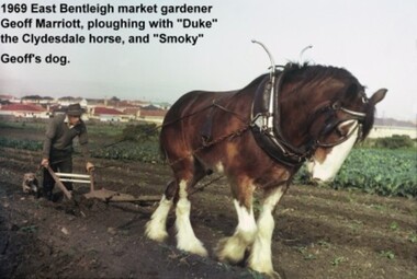 City of Moorabbin Historical Society (Operating the Box Cottage Museum)
Photograph - Photograph: Horse-drawn Plough at Work, 1969 Geoff Marriott ploughing in his Market Garden, 1969
... with a four-roomed house in East Boundary Road, in the area... Boundary Road, in the area then called East Brighton. (Now known ...Members of the Marriott family arrived in Port Phillip in 1857. However it was John and Jane Marriott who in 1876, (after toiling hard since their arrival in1871, for very little gain), first leased, then purchased in 1882, 30 acres with a four-roomed house in East Boundary Road, in the area then called East Brighton. (Now known as East Bentleigh). The land they purchased had previously been a part of the 1841 Dendy Survey. Over the following years, John and his four sons with hard work and determination became prosperous vegetable growers and purchased further land in the area. Following John's retirement and subsequent death in 1903, the land was passed to his sons, and then onto the Marriott grandchildren. The family continued to remain very prosperous and successful vegetable growers. This lovely photo of Geoff Marriott bears testament to just one of the many families steeped in the tradition of vegetable growing which significantly contributed to the prosperity of the Shire, and its subsequent development into the City of Moorabbin. The photograph of Geoff Marriott of the Marriott family represents a typical example of the MANY early market gardening families, some names less prominent, but who with their labours contributed to the prosperity and the development of the community of the Shire of Moorabbin. This group of early pioneers, over many years, were a singularly important group responsible for the growth of schools, churches, the Mechanic's Hall, and were active in local government. Large coloured photograph, taken in 1969, showing Mr Geoff Marriott with his horse-drawn plough pulled by "Duke" the Clydesdale horse, and accompanied by "Smoky", his dog, working in his market garden, Brady Road, East Bentleighhorse, brighton, moorabbin, pioneers, settlers, fruit, markets, vegetables, plough, mayors, moorabbin shire, moorabbin roads board, marriott geoff, marriott john, marriott jane, market gardens, horse drawn plough, city of moorabbin -
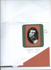 City of Moorabbin Historical Society (Operating the Box Cottage Museum)
Photograph, B&W, William Ward JP Councilor, 1820 - 1908, c1880
... purchased land in Tucker Road East Brighton (Bentleigh) 1870... owned land in East Boundary Road, Elsternwick, and Murrumbeena ...William Ward 1820- 1908 was born in Norfolk and emigrated with his wife Ann Ostler aboard the SS Kent in 1853. The voyage took 77days. William Ward JP was a prominent figure in East Brighton . William was elected to the Moorabbin Road Board in 1863, JP at Cheltenham Court, and Shire President 1875-82. He was appointed Post Master at East Brighton in 1865 and held the position until his death in 1908. William's Municipal career extended over 30 years and the 'Southern Cross Newspaper Brighton paid him tribute in the obituary January 25th 1908. William and Anne Ward had 10 children but only 5 survived. Elizabeth Emma Ward 1963- 1921, their eldest child, married Henry Box 1839-1913 and they had 9 children but 2 died in infancy. Henry Box purchased land in Tucker Road East Brighton (Bentleigh) 1870 to establish a market garden . He continued to purchase property through out his life and when he died owned land in East Boundary Road, Elsternwick, and Murrumbeena.William Ward JP was a prominent figure in East Brighton, William was elected to the Moorabbin District Road Board in 1863, JP at Cheltenham Court, and Shire President 1875-82. He was appointed Post Master at East Brighton in 1865 and held the position until his death in 1908. William's Municipal career extended over 30 years and the 'Southern Cross Newspaper Brighton paid him tribute in the obituary January 25th 1908.A black and white photograph of William Ward JP, Councillor who was the father of Elizabeth Emma Ward the wife of Henry Box.nil -
 City of Moorabbin Historical Society (Operating the Box Cottage Museum)
Document, laminated photocopy of 'Plan of Moorabbin 1850', 1853
... easterly from the Port Phillip Bay to East Boundary Road and from... Phillip Bay to East Boundary Road and from North Road to South ...Weston Bate, 'A history of Brighton' 1962 informs us that in 1840 Henry Dendy, who was a farmer in Sussex England, paid 5,120 pounds sterling @ 1pound per acre for a 'Special Survey of Land in Port Phillip , Australia. Henry arrived in Australia in 1841 on the frigate 'York' with his wife, son, and three servants. He also took advantage of the Government Assistance of Free Immigrants for Survey Purchasers, to help on his estate and persuaded some Sussex men with their families to follow him. However when Dendy arrived in Port Phillip he found that LaTrobe and Gipps were trying to raise the price of land close to Town to 15pounds per acre. Dendy asked merchant J.B.Were to manage his affairs and they went ahead with plans to subdivide the surveyed land called 'The Brighton Estate' This area of land extended easterly from the Port Phillip Bay to East Boundary Road and from North Road to South Road in the Parish of Bourke Victoria. The Privy Council, England , decide that Henry Dendy could purchase the land at 1pound per acre. Land Sales proceeded from 1844 as more immigrants established market gardens, farms and varied businesses in 'Moorabbin'This is a photocopy of a Map of the Moorabbin , County of Bourke c1850 showing the 'Henry Dendy Special Survey 1841'A photocopy of a Map of the Moorabbin , County of Bourke c1850. A3 size laminatedLeft corner : MOORABBIN / COUNTY OF / BOURKEdendy henry, dendy special survey 1841, brighton, moorabbin, ormond, bentleigh, market gardeners, pioneers early settlers, box william, box elizabeth -
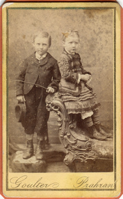 City of Moorabbin Historical Society (Operating the Box Cottage Museum)
Photograph, B&W, Possibly 2 children of Heny Box 1839 -1913, c1900
... , and at his death in 1913 owned property in East Boundary Road... death in 1913 owned property in East Boundary Road, Murrumbeena ...Henry Box ,who was born in Withyham in 1839 , was the 3rd son of George and Mary Cripps Box and came to Australia in 1856 with the family. Henry paid his own fare so was not ‘bound’ to any employer. Henry helped his brother William establish his market garden on the site of Box Cottage, Jasper Road 1865 and by 1870 was purchasing property in East Brighton (Bentleigh.). He continued to purchase land, which he rent / leased to family members, and at his death in 1913 owned property in East Boundary Road, Murrumbeena and Elsternwick. Henry married Elizabeth ‘Emma’ Ward in 1868 and they had 9 children but 2 died in infancy. ‘ Emma’ was the daughter of William Ward 1820- 1908 who was born in Norfolk and emigrated with his wife Ann Ostler in 1853. Henry was a member of the Court Pride of St George AOF, and a lay preacher at the Bentleigh Baptist Church.. Surviving Children were - Caroline Alma Box 1863-1943, Mary Anne Box 1865- ?, Lydia Elizabeth Box 1867- 1957, William Henry Box 1869- 1945, Emma Elizabeth Ellen Box 1875 – 1964, Olivia Christina ‘Chrissie’ Box 1878 – 1963, Archibald Ward Box 1882 -? Box Cottage Museum, a reconstruction of an early settler hut, is named after the Box family who resided there 1865 -1913 . William Box who with his wife Elizabeth Avis Box and 13 children lived and farmed on the block of land in Jasper Road, East Brighton ( now McKinnon / Ormond) that was part of the Henry Dendy Special Survey 1841 . Henry Box, a brother of William Box, was born in Withyham, Sussex and came to Australia with his parents George and Mary Box and siblings in 1856. He purchased property and helped the family establish market gardens in East Brighton (Bentleigh). Henry and his wife Elizabeth Emma Ward Box had 9 children, Henry was a lay preacher for the Baptist Church Bentleigh. Inscribed in Album “ The early photos in this album were found by Mr (Laurie) Lewis when he was demolishing the Old Box Cottage. He gave them to Mrs Avis Box Eldridge who in turn gave them to me. They were not identified. I believe they rightly belong in the Cottage. I have attempted to identify them and present them in a way they can be preserved as a historical record of the era.” A B Leigh A black and white photograph of a young girl and boy who may be 2 of the surviving 7 children of Henry Box 1839 -1913Goulter Prahran -
 City of Moorabbin Historical Society (Operating the Box Cottage Museum)
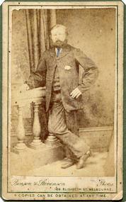
Photograph, B&W, Henry Box 1839 - 1913, c1888
... , and at his death owned property in East Boundary Road, Murrumbeena... death owned property in East Boundary Road, Murrumbeena ...Henry Box ,who was born in Withyham in 1839 , was the 3rd son of George and Mary Cripps Box and came to Australia in 1856 with the family. Henry paid his own fare so was not ‘bound’ to any employer. Henry helped his brother William establish his market garden on the site of Box Cottage, Jasper Road 1865 and by 1970 was purchasing property in East Brighton (Bentleigh.). He continued to purchase land, which he rent / leased to family members, and at his death owned property in East Boundary Road, Murrumbeena and Elsternwick. Henry married Elizabeth ‘Emma’ Ward in 1868 and they had 9 children but 2 died in infancy. ‘ Emma’ was the daughter of William Ward 1820- 1908 who was born in Norfolk and emigrated with his wife Ann Ostler in 1853. Henry was a member of the Court Pride of St George AOF, and a lay preacher at the Bentleigh Baptist Church.. Surviving Children were - Caroline Alma Box 1863-1943, Mary Anne Box 1865- ?, Lydia Elizabeth Box 1867- 1957, William Henry Box 1869- 1945, Emma Elizabeth Ellen Box 1875 – 1964, Olivia Christina ‘Chrissie’ Box 1878 – 1963, Archibald Ward Box 1882 -? Box Cottage Museum, a reconstruction of an early settler hut, is named after the Box family who resided there 1865 -1913 . William Box who with his wife Elizabeth Avis Box and 13 children lived and farmed on the block of land in Jasper Road, East Brighton ( now McKinnon / Ormond) that was part of the Henry Dendy Special Survey 1841 . Henry Box, a brother of William Box, was born in Withyham, Sussex and came to Australia with his parents George and Mary Box and siblings in 1856. He purchased property and helped the family establish market gardens in East Brighton (Bentleigh). Henry and his wife Elizabeth Emma Ward Box had 9 children, Henry was a lay preacher for the Baptist Church Bentleigh. Inscribed in Album “ The early photos in this album were found by Mr (Laurie) Lewis when he was demolishing the Old Box Cottage. He gave them to Mrs Avis Box Eldridge who in turn gave them to me. They were not identified. I believe they rightly belong in the Cottage. I have attempted to identify them and present them in a way they can be preserved as a historical record of the era.” A B Leigh A black and white photograph of Henry Box 1839 - 1913Bensen & Stevenson Photos / 108 Elizabeth St. Melbourne/ COPIES CAN BE OBTAINED AT ANY TIME -
 City of Moorabbin Historical Society (Operating the Box Cottage Museum)
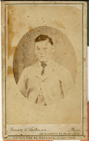
Photograph, B&W, a son of Henry Box 1839 -1913, c1900
... , and at his death in 1913 owned property in East Boundary Road... death in 1913 owned property in East Boundary Road, Murrumbeena ...Henry Box ,who was born in Withyham, Sussex in 1839 , was the 3rd son of George and Mary Cripps Box and came to Australia in 1856 with the family. Henry paid his own fare so was not ‘bound’ to any employer. Henry helped his brother William establish his market garden on the site of Box Cottage, Jasper Road 1865 and by 1970 was purchasing property in East Brighton (Bentleigh.). He continued to purchase land, which he rent / leased to family members, and at his death in 1913 owned property in East Boundary Road, Murrumbeena and Elsternwick. Henry married Elizabeth ‘Emma’ Ward in 1868 and they had 9 children but 2 died in infancy. ‘ Emma’ was the daughter of William Ward 1820- 1908 who was born in Norfolk and emigrated with his wife Ann Ostler in 1853. Henry was a member of the Court Pride of St George AOF, and a lay preacher at the Bentleigh Baptist Church.. Surviving Children were - Caroline Alma Box 1863-1943, Mary Anne Box 1865- ?, Lydia Elizabeth Box 1867- 1957, William Henry Box 1869- 1945, Emma Elizabeth Ellen Box 1875 – 1964, Olivia Christina ‘Chrissie’ Box 1878 – 1963, Archibald Ward Box 1882 -? Box Cottage Museum, a reconstruction of an early settler hut, is named after the Box family who resided there 1865 -1913 . William Box who with his wife Elizabeth Avis Box and 13 children lived and farmed on the block of land in Jasper Road, East Brighton ( now McKinnon / Ormond) that was part of the Henry Dendy Special Survey 1841 . Henry Box, a brother of William Box, was born in Withyham, Sussex and came to Australia with his parents George and Mary Box and siblings in 1856. He purchased property and helped the family establish market gardens in East Brighton (Bentleigh). Henry and his wife Elizabeth Emma Ward Box had 9 children, Henry was a lay preacher for the Baptist Church Bentleigh. Inscribed in Album “ The early photos in this album were found by Mr (Laurie) Lewis when he was demolishing the Old Box Cottage. He gave them to Mrs Avis Box Eldridge who in turn gave them to me. They were not identified. I believe they rightly belong in the Cottage. I have attempted to identify them and present them in a way they can be preserved as a historical record of the era.” A B Leigh A black and white photograph of a boy who could be a son of Henry Box 1839 -1913BENSEN & STEVENSON PHOTOS / 108 Elizabeth Street Melbourne/ COPIES CAN BE OBTAINED AT ANY TIME -
 Beechworth Honey Archive
Map- Albury
... regarding brigade boundaries, constructed access roads and fire... written on side regarding brigade boundaries, constructed access ...Map centred on Albury, showing Wodonga, Beechworth, Yackandandah and Chiltern. Topographic survey scale 1:100,000. Map is colour, printed on paper. Produced by Department of Minerals and EnergySheet 8225 (ed.1) series R. 652 Notes written on side regarding brigade boundaries, constructed access roads and fire trails, dams suitable for quick fill pump and areas 'fuel reduction burns Autumn 76'.map, albury, wodonga, beechworth, yackandandah, chiltern, paper, topographic, beechworth honey -
 Surrey Hills Historical Society Collection
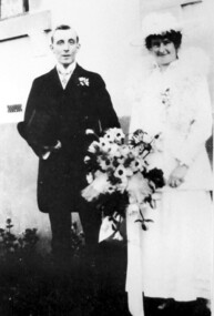
Photograph, Wedding Day of Amelia Amy Jacobs and James Dodgshun from Surrey Hills, 1916
... " in Boundary (Warrigal) Road, Surrey Hills. Amelia attended Ormiston... grandfather, "Terreglea" in Boundary (Warrigal) Road, Surrey Hills ...Amelia Allan (Amy) Jacobs on her marriage to James Dodgshun in 1916; photographed at the home of her grandfather, "Terreglea" in Boundary (Warrigal) Road, Surrey Hills. Amelia attended Ormiston Girls' School in Mont Albert soon after its opening in 1900. Her mother was Eleanor Mills, youngest daughter of Robert Shortbridge Mills and Ann Lovelady. She died soon after the birth of Amy. Her father was Henry Atwood Jacobs. Following Eleanor's death Henry married Amy Lilian Scales. The donor Winifred Yarnold (nee Jacobs) was their youngest daughter and Amy's half-sister.Lady dressed as bride wearing a white dress and possibly a lace jacket with a fluffy collar and matching hat, carrying a large bouquet of flowers. The man is wearing a dark suit and carrying a top hat.wedding dresses, house names, surrey hills, warrigal road, clothing and dress, hats, terreglea, the tower house, weddings, wedding parties, ormiston girls school, schools, mont albert, miss amelia allan jacobs, miss amy jacobs, mr james dodgshun -
 City of Moorabbin Historical Society (Operating the Box Cottage Museum)
Clothing - Clothing, City of Moorabbin Tie, Circa 1960s
... boundary Thomas Street ,and Bluff Road. In 1862 The Moorabbin... Port Phillip Bay , then East to Boundary Road, South to South ...The City of Moorabbin existed from 1934 until 1994. Henry Dendy's Special Survey in 1841 of 5,120 acres in the Parish of Moorabbin , extended from Port Phillip Bay , then East to Boundary Road, South to South Road and North to North Road and became known as Brighton. 1859 Brighton became a Borough with its boundary Thomas Street ,and Bluff Road. In 1862 The Moorabbin Roads Board was formed and the extended area now included Cheltenham, Hampton, Sandringham, Black Rock, Beaumaris, Mentone and Mordialloc .and Little Brighton became known as Bentleigh. In 1871 the area became known as The Shire of Moorabbin. Gradually the area was separated into The Borough of Sandringham 1917, ( Black Rock, Beaumaris , Sandringham and Hampton ) Borough of Mentone and Mordialloc 1920, ( Parkdale ). In 1934 The City of Moorabbin was established for the area from South East corner of Thomas Street and North Road , East to Warrigal Road, Clayton Road, Kingston Road , Lower Dandenong Road, then South along Nepean Highway to Balcombe Road and along Bluff Road, Cummins Road, Nepean Highway, Thomas Street to North Road In the 1994 Amalgamation of Councils the City of Moorabbin was divided between the new City of Kingston in the South ( from South Road) and the new City of Glen Eira to the North . It was the largest Municipality in Victoria with a population of 118,865 in 1974This tie c 1960 is a memento of the City of Moorabbin 1934 - 1994Maroon colour, polyester, man's tie with the crest of City of Moorabbin woven on front.around circle enclosing Coat of Arms ; CITY OF MOORABBIN city of moorabbin, moorabbin roads board, moorabbin, brighton, dendy's special survey 1841, early settlers, pioneers, market gardners, dendy henry, were jonathan b, cheltenham, bentleigh, mentone, sandringham, mair william, bent thomas -
 City of Moorabbin Historical Society (Operating the Box Cottage Museum)
Document - Genealogy Chart Henry Dendy (Photocopy), 19 thC
... Melbourne, bounded by North Road, East Boundary Road, South Road... Road, East Boundary Road, South Road and to the west by Port ...In 1840 Henry Dendy, a farmer in Surrey, England acquired a "Special Survey" from the Commissioners for Land and Emigration which gave Dendy the right to choose land in Port Phillip for the "bargain basement" price of only £1 per acre for 5120 acres, (an area of 8 square miles). The Special Survey also included the right to "the shipment of a worker for every £20 spent on land, whose free passage was paid by the Crown, equalling a total of 100 workers ". Accordingly Dendy sold his English holdings and paid the required £5120 and arrived in Melbourne in February 1841. However by this time land in the new colony was selling for £5 - £40 per acre. Because Henry Dendy possessed the order from the Colonial Office in London he was able to successfully oppose Super-intendant LaTrobe's attempts to alter the price of the land. Dendy appointed Jonathan Were, (an entrepreneur, who had arrived in 1839), as his Manager and who later became a partner. Together, Dendy and Were decided on an area 5 miles south from Melbourne, bounded by North Road, East Boundary Road, South Road and to the west by Port Phillip Bay. Were and Dendy pitched their tents in the area now known as ' Park St, Brighton' and sank a well near the corner of 'St Andrew's St and Wells St'. By 1845 J.B Were and Company had bought almost half of Dendy's land and Were built himself "Moorabbin House" in Were St Brighton made from stone, quarried from local cliffs. It was still standing in 1924. Legend records Moorabbin is named after the Aboriginal word for ' Mother's Milk ' The soil is very fertile and well supplied with water especially in the area called 'East Brighton' - now known as Bentleigh and East Bentleigh - By 1850 the area had developed with numerous market gardens, dairy farms, fruit gardens and vineyards supplying food for the growing population of Melbourne.In 1840 Henry Dendy, a farmer in Surrey, England acquired a "Special Survey" from the Commissioners for Land and Emigration which gave Dendy the right to choose land in Port Phillip for the price of only £1 per acre for 5120 acres. This land was called Brighton in the Parish of Moorabbin, County of Bourke and emigrants developed the land establishing market gardens , dairy and poultry farms that provided the food for the growing population of Melbourne. A photocopy of the Genealogy Chart of the Dendy Family that Henry Dendy brought with him when he emigrated to Melbourne 1841Genealogy signs and descriptionsdendy henry, dendy's special survey brighton 1841, governor gipps, captain lonsdale, super-intendant latrobe, port phillip, melbourne, new south wales, squatters, emmigrants, county of bourke, parish of moorabbin, early settlers, pioneers, market gardeners, dairy farmers, fruit farms, moorabbin, bentleigh, brighton, cheltenham, were jonathan binn, -
City of Moorabbin Historical Society (Operating the Box Cottage Museum)
Document, Henry Dendy family Shield
... Melbourne, bounded by North Road, East Boundary Road, South Road... Road, East Boundary Road, South Road and to the west by Port ...In 1840 Henry Dendy, a farmer in Surrey, England acquired a "Special Survey" from the Commissioners for Land and Emigration which gave Dendy the right to choose land in Port Phillip for the "bargain basement" price of only £1 per acre for 5120 acres, (an area of 8 square miles). The Special Survey also included the right to "the shipment of a worker for every £20 spent on land, whose free passage was paid by the Crown, equalling a total of 100 workers ". Accordingly Dendy sold his English holdings and paid the required £5120 and arrived in Melbourne in February 1841. However by this time land in the new colony was selling for £5 - £40 per acre. Because Henry Dendy possessed the order from the Colonial Office in London he was able to successfully oppose Super-intendant LaTrobe's attempts to alter the price of the land. Dendy appointed Jonathan Were, (an entrepreneur, who had arrived in 1839), as his Manager and who later became a partner. Together, Dendy and Were decided on an area 5 miles south from Melbourne, bounded by North Road, East Boundary Road, South Road and to the west by Port Phillip Bay. Were and Dendy pitched their tents in the area now known as ' Park St, Brighton' and sank a well near the corner of 'St Andrew's St and Wells St'. By 1845 J.B Were and Company had bought almost half of Dendy's land and Were built himself "Moorabbin House" in Were St Brighton made from stone, quarried from local cliffs. It was still standing in 1924. Legend records Moorabbin is named after the Aboriginal word for ' Mother's Milk ' The soil is very fertile and well supplied with water especially in the area called 'East Brighton' - now known as Bentleigh and East Bentleigh - By 1850 the area had developed with numerous market gardens, dairy farms, fruit gardens and vineyards supplying food for the growing population of Melbourne. dendy henry, dendy's special survey brighton 1841, governor gipps, captain lonsdale, super-intendant latrobe, port phillip, melbourne, new south wales, squatters, emmigrants, county of bourke, parish of moorabbin, early settlers, pioneers, market gardeners, dairy farmers, fruit farms, moorabbin, bentleigh, brighton, cheltenham, were jonathan binn, -
 City of Moorabbin Historical Society (Operating the Box Cottage Museum)
Document - Pedigree of Henry Dendy, c1840 Original ; Copy 1985
... Melbourne, bounded by North Road, East Boundary Road, South Road... Melbourne, bounded by North Road, East Boundary Road, South Road ...This is a copy of the document brought by Henry Dendy to the Colony in 1841. In 1840 Henry Dendy, a farmer in Surrey, England acquired a "Special Survey" from the Commissioners for Land and Emigration which gave Dendy the right to choose land in Port Phillip for the "bargain basement" price of only £1 per acre for 5120 acres, (an area of 8 square miles). The Special Survey also included the right to "the shipment of a worker for every £20 spent on land, whose free passage was paid by the Crown, equalling a total of 100 workers ". Accordingly Dendy sold his English holdings and paid the required £5120 and arrived in Melbourne in February 1841. However by this time land in the new colony was selling for £5 - £40 per acre. Because Henry Dendy possessed the order from the Colonial Office in London he was able to successfully oppose Super-intendant LaTrobe's attempts to alter the price of the land. Dendy appointed Jonathan Were, (an entrepreneur, who had arrived in 1839), as his Manager and who later became a partner. Together, Dendy and Were decided on an area 5 miles south from Melbourne, bounded by North Road, East Boundary Road, South Road and to the west by Port Phillip Bay. Were and Dendy pitched their tents in the area now known as ' Park St, Brighton' and sank a well near the corner of 'St Andrew's St and Wells St'. By 1845 J.B Were and Company had bought almost half of Dendy's land and Were built himself "Moorabbin House" in Were St Brighton made from stone, quarried from local cliffs. It was still standing in 1924. Legend records Moorabbin is named after the Aboriginal word for ' Mother's Milk ' The soil is very fertile and well supplied with water especially in the area called 'East Brighton' - now known as Bentleigh and East Bentleigh - By 1850 the area had developed with numerous market gardens, dairy farms, fruit gardens and vineyards supplying food for the growing population of Melbourne. A copy of a paper chart of the Pedigree of Henry Dendy in a wooden frame with glassPedigree / of the branch of the family / DENDY moorabbin, brighton, henry dend special survey 1841 y, early settlers, pioneers, market gardeners -
 Linton and District Historical Society Inc
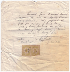
Receipt, Receipt for Payment for a Block of Land near Linton, 1918
... and house, but a block just outside the town boundary, near... and house, but a block just outside the town boundary, near ...Note that the block of land which was traded was not the block in Sussex Street, Linton on which the Sandows had a shop and house, but a block just outside the town boundary, near the Geelong Road (Linton-Naringhil Road). See map of Parish of Argyle for clarification.Photocopy of original handwritten receipt, which was for payment in full for a block of land situated just outside of Linton - Section A, Crown Allotment 1, Parish of Argyle. This land was purchased by Rubina (Ruby) Sandow from George Bolte in 1918. Receipt is for fifteen pounds, it is made out to "Rubinia Norwood Sandow" and is signed by Alf J. Smith, "for Geo. Bolte". Two Victorian Stamp Duty stamps are attached to the original document.rubina (ruby) sandow, george bolte, receipts, sale of land -
 City of Moorabbin Historical Society (Operating the Box Cottage Museum)
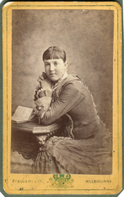
Photograph, B&W, possibly Elizabeth Emma Ward wife of Henry Box, 1880
... , and at his death owned property in East Boundary Road, Murrumbeena... death owned property in East Boundary Road, Murrumbeena ...Henry Box ,who was born in Withyham in 1839 , was the 3rd son of George and Mary Cripps Box and came to Australia in 1856 with the family. Henry paid his own fare so was not ‘bound’ to any employer. Henry helped his brother William establish his market garden on the site of Box Cottage, Jasper Road 1865 and by 1970 was purchasing property in East Brighton (Bentleigh.). He continued to purchase land, which he rent / leased to family members, and at his death owned property in East Boundary Road, Murrumbeena and Elsternwick. Henry married Elizabeth ‘Emma’ Ward in 1868 and they had 9 children but 2 died in infancy. ‘ Emma’ was the daughter of William Ward 1820- 1908 who was born in Norfolk and emigrated with his wife Ann Ostler in 1853. William Ward JP was a prominent figure in East Brighton . William was elected to the Moorabbin Road Board in 1863, JP at Cheltenham Court, and Shire President 1875-82. He was appointed Post Master at East Brighton in 1865 and held the position until his death in 1908 Henry was a member of the Court Pride of St George AOF, and a lay preacher at the Bentleigh Baptist Church.. Surviving Children were - Caroline Alma Box 1863-1943, Mary Anne Box 1865- ?, Lydia Elizabeth Box 1867- 1957, William Henry Box 1869- 1945, Emma Elizabeth Ellen Box 1875 – 1964, Olivia Christina ‘Chrissie’ Box 1878 – 1963, Archibald Ward Box 1882 -? Box Cottage Museum, a reconstruction of an early settler hut, is named after the Box family who resided there 1865 -1913 . William Box who with his wife Elizabeth Avis Box and 13 children lived and farmed on the block of land in Jasper Road, East Brighton ( now McKinnon / Ormond) that was part of the Henry Dendy Special Survey 1841 . Henry Box, a brother of William Box, was born in Withyham, Sussex and came to Australia with his parents George and Mary Box and siblings in 1856. He purchased property and helped the family establish market gardens in East Brighton (Bentleigh). Henry and his wife Elizabeth Emma Ward Box had 9 children, Henry was a lay preacher for the Baptist Church Bentleigh. Inscribed in Album “ The early photos in this album were found by Mr (Laurie) Lewis when he was demolishing the Old Box Cottage. He gave them to Mrs Avis Box Eldridge who in turn gave them to me. They were not identified. I believe they rightly belong in the Cottage. I have attempted to identify them and present them in a way they can be preserved as a historical record of the era.” A B Leigh A black and white photograph of a young woman who may be Elizabeth Emma Ward 1863 - 1921,the wife of Henry Box.1839-1913Stewart & Co ' Coat of Arms" Melbourne -
 Eltham District Historical Society Inc
Document - Folder, Request for change of boundary, 1870
... Document dated December 13 1870 re the change of boundary... melbourne Document dated December 13 1870 re the change of boundary ...Document dated December 13 1870 re the change of boundary between the Greensborough Road Board and the Eltham Road Boards severance of land East of the Diamond Creek boundary. Photocopy from Letters collection, Shire of Eltham. Folder 81 from Harry Gilham Collection 3 pageswingrove, herbert, alexander donaldson, john stevenson, roads