Showing 89 items matching "e. reynolds"
-
 Federation University Historical Collection
Magazine - Booklet, Ballarat School of Mines Students' Magazine, 1952, 1952
School Council, Members of Staff, Editorial, Principal's Page, Magazine Committee, Obituary - Rupert P. Flower, Literary Society, Prominent Personalities, Science School, News and Notes, Prize Presentation, The Apprentices, Boys Sport, Sun Youth Travel Memoirs, The Art School, His Majesty the Late King George VI, Commercial Notes, Gleanings Here and There, Junior School, Girls Sport, Sport, House Notes, Junior Technical School Students', Roll Call - Diploma Students 1952Pale blue soft covered magazine with navy blue titles.ballarat school of mines, magazine, mr bryan, c. sanos, s. deans, j. williams, r. simpson, c. g. fairbank, d. treadwell, e. aitkens, g. birkett, g. allen, f. benjamin, s. gillespie, r. hullick, h. mccallum, h. harris, j. walton, e. walsh, j. stevens, b. clark, rupert p. flower, john bechervaise, w. keith hindson, a. james tinney, walter c. tooth, john d. bethune, vilma sansom, betty clark, travers duncan, joyce wilson, lex lockhart, jim w. beattie, joyce stevens, slim ingleton, a. eddy, john howard, douglas george dean, edgar bartrop, colin mck. henry, tom adams, max kennedy, jeff coward, o. j. nilsen, j. skuja, s. rowe, w. maddox, a. kinnane, d. fraser, a. carpenter, john james, b. flavel, j. murray, d. schmidt, g. habel, t. duncan, l. matthews, n. spiers, b. smith, a. tonnisseu, r. ingleton, j. bethune, j. mills, j. mcneil, b. schreenan, w. carlyon, d. stevens, l. j. hillman, k. hindson, r. furlong, j. beattie, b. taylor, g. heyes, l. quilliam, r. archer, a. johnson, m. gillin, t. seabrook, m. phillips, j. sawyer, c. restarick, j. saggers, g. ditchfield, j. tinney, don stewart, j. faneco, m. stevens, w. tooth, ron simpson, bill maxwell, graham searle, jim tinney, k. treloar, j. barnes, s. j. deans, lynette j. blomeley, georgina cox, heather mcgregor, janet saunders, heather harris, elizabeth mcarthur, norma coffield, pat lavery, imelda lee, gloria white, valerie westbrook, cynthia stone, janice thompson, clare mooney, glenys perry, faida lewis, betty clarke, marion volk, isla veal, valerie yates, coralie mckenzie, lorraine digby, barbara henderson, deidre wilson, margaret henderson, barbara ngip, glenys sleeth, anne duncan, l. dwyer, elaine leishman, j. jenkin, stirling gillespie, w. bridges, b. baldock, b. braybrook, e. mackie, r. braybrook, c. grose, b. mackie, c. garnham, c. schmidtke, t. lugg, j. copeman, b. tozer, g. mathews, n. sutherland, r. lambert, j. sanders, m. quick, j. collier, g. pike, r. digby, r. quayle, r. sharp, n. brogden, r. lyons, p. stevens, j. bastin, b. kay, k. duncan, b. golding, l. norman, b. murnane, k. hocking, c. sealey, b. langdon, f. weightman, m. birch, r. stevenson, r. stewart, r. haintz, k. mccoll, k. jarvis, l. hocking, d. curtain, r. lazarus, e. boak, j. fletcher, b. orchard, j. squires, n. pike, j. shrader, l. reynolds, m. ritchie, g. smith, d. parkes, g. templeton, m. wunhym, v. vincent, d. robertson, d. lang, l. horwood, d. searle, d. new, v. jolly, a. minotti, b. beaumont, m. marshall, e. bowen, j. rogers, d. cody, e. kinnane, j. cunningham, j. schrader, r. horgan, j. white, n. flood, j. matthews, h. gale, k. mitchell, v. rowse, j. mayne, a. gilbert, b. warrillow, g. gilbert, n. quick, m. hall, d. furlong, n. lyons, j. richards, j. jones, l. major, d. baldock, d. dow, g. ruddick, d. howell, j. caddy, b. singleton, b. powell, r. sharpe, c. lockhart, l. daff, c. sharpe, d. irish, l. dow, a. douglas, n. twaites, j. courtney, l. beacham, n. c. cartledege, cliff sealey, j. f. collier, e. g. mackie, m. g. quick, b. l. collinson, j. n. bastin, g. e. timmins, valerie mills, j. a. jenkin, w. cowan, i. mitaxa, n. c. leckie, r. j. austin, n. coffield, d. quilliam, r. courtney, f. m. kilfoyle, p. nunn, king george vi -
 Federation University Historical Collection
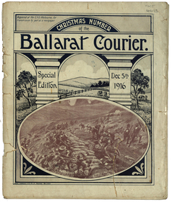
Magazine - Photograph - Black and White, Berry, Anderson & Co, Ballarat Courier Special Christmas Edition, 1916, 1916
A magazine supplement of the Ballarat Courier containing articles, images and advertisement. Images include: St Patrick's Day March, Eight Hour Day procession Advertisements include: Morris undertaker, Olivers, Miller, Hanrahan's Hotelst patrick's day, ballarat townscape, st patrick's day parade, ballarat st patrick's day parade, ballarat courier, hanrahan, morris, labour day, 8 hour day, eight hours day procession, st patrick's day procession, mrs captain ellis, picture palace, grenville college, berry united company ullina, lewis s. smith architect, bolster brothers, buninyong butter factory, aquatic carnival, george e. deeble machinery, cape nelson portland, jelbarts, jelbart's telescope, lin hillman, presbyterian church snake valley, miss a.m. abrams, berry anderson and co, j.a. reynolds, maypole, w.f. coltman, ballarat boot palace, ben nevis elmhurst, jonathan reeve, victorian producers co-operative, r.u. nicholls, f.w. barnes and son, ballarat steam laundryballarat water reserves, yarra river warburton, erskine river lorne, john bray, eden studios, lake wendouree -
 Federation University Historical Collection
Booklet - Magazines, Ballarat School of Mines Magazine, 1924-1930, 1924-1930
The Ballarat School of Mines is a predecessor institution of Federation University Australia. Bound copies of the Ballarat School or Mines Students' Magazine. 1924 * Dr J.R. Pound * Noel Hay Obituary * The History of Chemistry * Literary Society * Herald B. Herbert * Chemistry in Modern Life by Val G. Anderson * Chemistry in Literature by J.R. Pound * School Literary Society * Ladies in Pharmacy * Musings on Modern Literature - Mainly Drama (W.G. C.) * Trip to Newcastle * Appreciation of the Masterpieces of Art * The Antique Room * Dressmaking * Pottery * Sloyd * The Mystery of the Atom *Inorganic Evolution by R.S. Russell * Photography * First Aid Club 1926 * The Trip to Morwell * Chemical Excursions (Yallourn) * Eastern Life and Customs by Rex Warrillow * Organic Evolution by Edwin A. Brophy * Chemistry in the Kitchen * Obituary for Professor Alfred Mica Smith * The Historical Development of Patterns i Silk Fabrics * Pottery * Literary Society * Early Evidence of Metallurgy in Britain * Brief Description of the Magnet Silver Mine, Tasmania * The manufacture of Leather Photographs * SMB Athletics Team, winners of the Herald Shield (M. Timmings, L. Evans, F. Sheahan, R. Collins, A. Murfett, W. Hughes, L. Hillman * SMB Football Team * Ballarat Technical Art School Tennis Four * SMB Girls' Basketball Team * SMB GIrls Hockey Team * Ballarat Junior Technical School Scholarship and Studentship Winners * On Punctuation Advertisements: Sunshine Biscuits, Harris Powell and Sandford, W. Gribble & Co., Gilbert Motors, T.J. Haymes The Wallpaper King, C. Marks and Co., Wilson's Tailors and Mercers, George S. Grant, Miss A. Corin Art Worker, Tunbridges, Felton, Grimwade & Co., Hasten and Ewins, Ballarat Wireless Stores, Fred A. Reed, Suttons, E. Hall-Jones, Stansfield and Smith, Ballarat Gas Company, Richards and Co Studio, F.H. Drew, Adam Scott, R.A. Hudson, Huttons, J.A. Holland, A.E. White, F. Barrow Monumental Sculptor, R. Young, H.A. Evans, Alexandria Tea Rooms, W. Cornell Chemist, Black Cat Tea Rooms, J.A. Reynolds, A.M. Palmer, Morris Cars and Trucks, Mrs Stones, Millers The Clothiers, T.G. Skewes, Wattle TEa Rooms, H.B. Selby, Middleton and Morris, C.P.A. Taylor, Thornton Studios, Fred Irwin, Isaac Abraham, Ballarat Radio Listening-In, Baxter and Stubbs 1927 * Chemists Trip to Melbourne (Mount Lyell Chemical Works, Footscray, Yarraville * Literary Society * Mr J.N. Rowell 1928 * Prohibition in U.S.A. by Ed A. Brophy * Dr. J.W. Mellor and His Work at Stoke, England by Reginald C. Callister * The Science of Chemistry by C.A. Schache * Trip to Yallourn (Brown Coal Deposits, Steam Plant at Yallourn, Switchgear and Transformers, Briquette Factory * Walhalla Past and Present by G.E.B. * The Hand Loom * Precious Stones 1929 * The Old Brewery * The History of Chemistry by J.R. Pound * Occurrence of Mineral Oil in Gippsland * Experiences with Malayan Chinese by R. Warrillow * Organise Colors (Dyestuff Pigments) in Rubber Goods 1930 * News from Chine by Henry Kum Yuen * L'Art Moderne * The Story of Clay by T.H. Trengrove * A Glimpse of England * The Beginnings of Arithmeticballarat school of mines, pottery, ceramics, reginald callister, metallurgy, chemistry, j. pound, alfred mica smith, herald shield, harold herbert, lindsay hillman, john rowell, j.r. pound, noel hay, drawing from antique, yallourn excusion, walhalla, sunshine biscuits, harris powell and sandford, w. gribble & co., gilbert motors, t.j. haymes, the wallpaper king, c. marks and co., wilson's tailors and mercers, george s. grant, miss a. corin art worker, tunbridges, felton, grimwade & co., hasten and ewins, ballarat wireless stores, fred a. reed, suttons, e. hall-jones, stansfield and smith, ballarat gas company, richards and co studio, r.a. hudson, huttons, j.a. holland, a.e. white, f. barrow monumental sculptor, r. young, h.a. evans, alexandria tea rooms, w. cornell chemist, black cat tea rooms, j.a. reynolds, a.m. palmer, morris cars and trucks, mrs stones, millers the clothiers, t.g. skewes, wattle tea rooms, h.b. selby, middleton and morris, c.p.a. taylor, thornton studios, fred irwin, isaac abraham, ballarat radio listening-in, baxter and stubbs, mount lyell chemical works, footscray, c.a. schache, yallourn briquette factory, t.h. trengrove, history of chemistry, excursions, morwell, morwell excursion, women in pharmacy, mt lyall, excursion, slloyd, drawing from the antique, james pound, yallourn, yallourn excursion, ballarat arch of victory, mt macedon, f.h. drew, adam scott, university women -
 Federation University Historical Collection
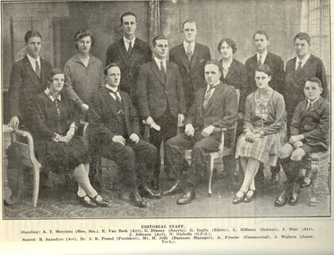
Magazine - Booklet, Ballarat School of Mines Students' Magazine, 1936, 1936
List of Full Course Students' 1936, Editorial, Obituary - L. Hill, Personal Column, Old Boys' Personal, Fumes from the Lab, The Newcastle Trip, War and Women, Arts & Crafts Gossip, Sport, Commercial Notes, The Junior TechsYellow soft covered magazine of 60 pages, including advertisements. Artwork * Mr. C - By Albino Paganetti * Bo'sun - By Albino Paganetti * " So then says I ' you can't ask me to do that, boys - its dishonest," - By Jessie Hopwood * come on "(hic)" be serious - By Albino Paganetti * Bill - By Albino Paganetti * Mac - By Albino Paganetti * "I used the fruit bowl this time fro a change" - By Dorothy Woolcock * Mother & Bobby - By Dorothy Woolcock * Ernie - By Nornie Gude * Gateway to the Garden city - By Albino Paganetti * Tip - By Albino Paganetti * Pat - By Jean Coates * Our Dark Horse - By Jean Coates * Moorish Tower, Perth University - By Jessie Hopwood * Sailing Ship Print - By Verma Lynch * Lemon - By Albino Paganetti * Site for the King George memorial - By Gilda Gude * Gladys - By Dorothy Woolcock? * Our Tall Story - By Dorothy Woolcock * Another one today Sylvia - By Nornie Gude * Haze - By Dorothy Woolcock * Commercial Notes - By Leila McLachlan * Fred - By Albino Paganetti * Gordon - By Betty Brown * Gandhi - By Dorothy Woolcock * Ellie - By Gilda Gude * Betty - By Alan Nye * Lost Ball - By E. Prout * Cleaning Ladies - Betty Brown * Rusty - By Gilda Gude * Blondie - By Gilda Gude * Peggy - By Betty Brown * Hocky - By Gilda Gude * Betty - By Gilda Gude * Joan - By Gilda Gude * General - By Max Coward * Twitter - By Gilda Gude * Banjo - By Max Coward * Georgie - By Max Coward * Skinny - By Max Coward * Sydney Jim - By Max Coward * Tommy - By Max Coward * Max - By Max Coward * SOS - By Max Coward * Nipper - By Max Coward * Dasha - By Max Coward * Wee Macgregor - By Albino Paganetti Signed on front cover by "H. Darby".ballarat school of mines, magazine, allan nye, r. rickey, a. gordon, reg warnock, maxwell bayley, sylvia wyres, m. mcrae, albino paganetti, victor hunt, lila welsh, f. g. procter, mr. cochrane, w. coates, d. shore, jessie skelton, l. hill, k. h. wilkie, j. pound, h. maddern, n. pickering, john elliott, paul f. chaplin, w. usebach, fergy and p. macgregor, j. hammer, k. ellwood, j. w. muir, john menhennett, philip harris, j. anderson, william mcdonald, lawrence egan, archibald sneddon, p. holioake, lyle dimsey, a. horsfall, eoin macdonald, james martin, jack mole, bill walters, david flynn, william williams, dororthy billings, clarice mcintosh, gladys bilney, ida shearer, j. brady, g. lamb, grace gordon, elva brimacombe, r. hutchinson, g. leviston, i. mcdonald, w. callighan, t. jones, s. j. chambers, russell ewins, g. berriman, j. walker, r. t. hocking, f. e. capuano, f. w. hassell, c. m. reynolds, r. davies, r. c. white, h. f. forrest, h. h. evans, a. j. ritchie, j. g. kittelty, w. cornish, l. liebhardt, r. allender, a. pobjoy, a. laing, w. j. paterson, v. e. jukes, h. v. bolt, l. c. henderson, c. f. white, nornie gude, gilda gude, max coward, alan nye, betty brown, leila mclachlan, dorothy woolcock, verma lynch, jessie hopwood, jean coates, e. prout -
Federation University Historical Collection
Booklet, J.A. Hoskin & Son, Ballarat School of Mines Students' Magazine, 1954, 1954
Editorial, Principal's Page, Prominent Personalities, Eureka Stockade, Two ex-students tell of their work and conditions in East Africa and Canada, The Art School, Literary Society, Boys Sport, Football, Cricket, Baseball, Athletics, Tennis, Chris Sanos - another ex-student describes his recent trip to Greece, Junior School, Ballarat wins Final - Football Premiers 1954, Some Impressions of London, House Notes, School Council. Members of Staff, Roll Call Diploma Students, Junior Technical School Boys' and Girls' Students ListingGray soft covered magazine with red and brown titlesballarat school of mines, magazine, j. collier, john skuja, janice wilton, murray gillan, neil andrews, ellen freemantle, alan johnson, graeme willey, diana mainwaring, b. v. mcdougall, margaret little, lance matthews, philip davis, john barnes, cliff restarick, philip kempe, barry jones, harold everett, j. jenkin, r. howard, d. lavery, j. williams, j. barnes, j. murray, j. wolfe, j. clelland, t. gallagher, w. maxwell, n. andrews, b. bellingham, f. shearer, n. spears, i. schunke, d. schmidt, g. willey, r. furlong, g. rasdell, b. tozer, l. matthews, w. saggers, b. taylor, j. watts, a. johnson, b. matthews, r. dunlop, b. mclennan, g. ditchfield, m. gillin, j. cleelland, b. singleton, d. overall, g. crawford, chris sanos, nancy rimmington, janice tonkin, herbert "andy" andrews, leonard (a.p.c) doull, harold m. everett, murray "gilligan" gillin, alan "johno" johnson, khoo teng seong, douglas "myxo" lockhead, lancelot "willey" matthews, bruce "frugal" mcdougall, "aal" pitzen, john "cheesy" skuja, brian francis "tailspin" taylor, john "tucks" watts, lola andrich, j. spencer, r. cutter, p. collier, g. paddle, n. richards, i. pike, b. cushion, b. knight, g. van berkel, d. stevens, n. stevens, b. stevens, l. major, l. copeman, k. norman, n. hodder, l. johns, l. curtis, h. hay, l. furlong, g. new, j. hamilton, r. day, a. clarke, b. parker, p. agrums, l. dean, w. swan, r. carlson, t. white, m. walsh, r. gilbert, w. edmends, b. vurlow, d. wakeling, a. haywood, d. sarah, k. rogers, l. cook, j. mcleod, p. hatton, p. fisher, r. lambert, j. vincent, t. lugg, g. matthews, w. etty, n. twaits, m. o'brien, w. davidson, i. lightfoot, p. cahill, n. slocum, d. martin, j. leckie, marjorie garner, r. hall, i. beaumont, barbara o'connell, b. duthie, l. boyd, i. kinnane, d. baldock, p. nunn, j. strickland, d. robertson, n. everett, b. whittle, w. widdop, j. richards, b. tresize, k. buchanan, m wunhym, j. caddy, g. kerr, j. collins, r. sansom, i. gitsham, k. weightman, g. gilmer, e. waller, r. mcbride, j. jardine, lynette reynolds, marion ritchie, p. mchenry, h. cromb, c. veal, j. van buerghel, g. templeton, k. page, e. tozer, b. wilson, g. minehan, g. smith, j. bennett, n. pike, l. reynolds, m. ritchie, m. wunhym, l. willis, m. nolan, j. rogers, e. kinnane, g. cody, j. mills, j. cunningham, m. eggleton, n. rimmington, m. marshall, n. gay, e. hosking, v. jolly, j. mchenry, rosalie hall, brian duthie, m. lesins, l. hotchin, g. hill, e. richards, l. jardine, m. roberts, i. siver, d. mclennon, k. warhurst, r. rowse, e. snowball, g. jill, n. bromley -
 Federation University Historical Collection
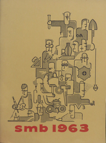
Booklet, Ballarat School of Mines Students' Magazine, 1963, 1963
Ballarat School of Mines Students' Magazine, 1963. Editorial, Prominent Personalities, King Island - Vacation Wonderland, Look back in Wonder, The Sensible Enemy, Diploma Conferring Ceremony, R. W. Richards Medal, Diplomas Conferred, Personality Tests and the Individual, Poison to Poison - Students' Revue for 1963, Malaya, Income Tax, Rustling Rags, Where Mankind has Failed, Sports Awards 1963, Sports, School Council, Members of Staff, Roll Call Yellow soft cover with red inscriptions and black figures on front cover, 104 pages including advertisements.ballarat school of mines students' magazine 1963, staff, sports, tony brauer, bob coutts, paul pusari, jeni milbourne, kerry penna brian mclennan, bob grub, john davis, netta walta, kevin brady, oscar rogers, kuo yiew see, h. e. arblaster, stanley white, quentin reynolds smyth, l. p. coombes - chief superintendent aeronautical research laboratories melbourne, graeme george redman, robert skewes, chookiat tanaksaranond, alan james bethune, lachlan stewart campbell, graham william hall, john rash, alan kenneth webb, peter agrums, sr. mary chanel fitzsimmons, david ewan clarke kirton, william joseph lannen, neil frances menz, keith houston alexander, john alexander pollock, john peter russell, francis william hunting, chookiate sirivongse, chong thung tay, keith stanley waller, bryan magson, anne moorehouse, stephen drew, gerry liston, gary roberts, ray megee, peter smith, daila berzins, don yates, kelvin whitford, greg hunter, david bell, michael moissinac, neil mudge, arthur patterson, edward scull, joseph heller, g. roberts, j. humphreys, bobby ong, alan cox, p. l. day, r. coutts, wayne johnson, prasert mahattanakul, l. t. negri, ooi kok hai, photography -
Federation University Historical Collection
Book, Ballarat School of Mines Stubb Book (relating to payments to staff), 1911-1912, 1911-1912
Hard covered stubb book with bluecover and red tape spine. Lists Ballarat School of Mines staffmembers, and the amount of wages they were paid. ballarat school of mines, salary, wages, f.j. martell, h.j. hall, a.e. kerr, h.r. murphy, j.b. robinson, j.m. sutherland, b. whitington, a.g. garrard, c. deane, e.j. mcconnon, f.w. hawkins, s. baker, j. brittain, h.h. smith, m. young, a. lilburne, a.w. steane, j. jolly, f. foster, a. bowman, h. cornell, b. reynolds, c.c. courie, f. king, j.l. eddy, w.h. steane, g. slater, i. williams, j. barber, d. mullins, herbert malin, j. wright, boy's wages, northern assurance company, a. pearce, francis jago, l. coulter, ballarat library, h.b. silberberg company, w. cornell, singer company, mcvitty and company, m. noble, a. buluss, r. sim and co, j.h. trotman, l. scarff, howard smith, north brittain company, alfred mica smith, daniel walker, t.s. hart, j. b. robinson, e. green, a.d. gilchrist, f. thursfield, j.e. white, c.c. corrie -
Port Melbourne Historical & Preservation Society
Document - List of Port Melbourne Hotels & Licencees 1872, 1872
Handwritten list of hotels & their licencees in 1872 believed to have been complied by donor's ancestor, a member of the LOBB family.A4 size handwritten sheet with names, addresses and licencees of Port Melbourne hotels in 1872.business and traders - hotels, built environment - commercial, lobb, h. fonseca, harry hall, william hays, j mcculloch, wm reynolds, g sefton, mrs crockford, andrea lagogiannis, g braithwaite, v sanderson, j carter, g w hall, j michie, t cowling, jas. bartlett, edward suffolk, martin clasby, mrs peatt, w kinyon, william spire, thomas turville, w cruickshank, charles peacock, j williams, william cannon, j bell, michael flanagan, william carroll, j w carr, john allen, j e crockford, charles sharp, henry o'brien, g t potter, f johnson, all england eleven hotel, army & navy hotel, auld reekie hotel, australian hotel, bay view hotel, brunswick pier hotel, chequers inn, chusan hotel, commercial hotel, cosmopolitan hotel, customs house hotel, exchange hotel, fitzjames hotel, floodgate hotel, foresters arms hotel, foundry hotel, fountain inn, freemasons hotel, happy home hotel, hibernian hotel, kent hotel, locomotive hotel, lord raglan hotel, marine hotel, naval brigade hotel, new great britain hotel, pier hotel, president lincoln hotel, prince alfred hotel, retreat inn, royal hotel, ship hotel, station hotel, victoria hotel -
 Essendon Football Club
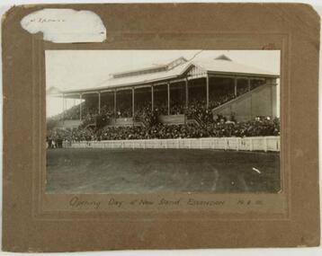
New grandstand
Essendon arrived at the Essendon Recreation Reserve (later known as Windy Hill) in 1922. In August that year the club opened its first grandstand before the round 14 game against Richmond. It was later named the Dick Reynolds Stand.This historic photograph shows supporters crammed into the grandstand that day.Black and white photograph on brown cardboard mount with imprinted border; remains of a white sticker in upper left corner. "E. Franklin Moonee Ponds 37 6794" hand-written in blue biro on reverse."Opening day of new stand, Essendon 19.8.22" -
 Geelong Cycling Club
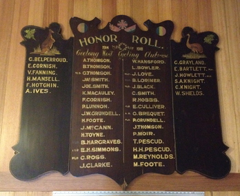
WW1 Honor Roll, Circa 1918
A chronicle of G.W.C.C. members who joined the Armed Forces for the 1914-1918 War (WW1) noting those who paid the ultimate sacrifice.This honour board signifies the high esteem in which the community held for those soldiers who joined the armed forces during WW1. The large list of names from this relatively small cycling club indicates the huge sacrifice all communities made during this time of war. It is a statement of patriotism, service and sacrifice.Large 3 piece hardwood dark stained timber Honour Board. Names of GWCC members who served in WW1 depicted in gold lettering. Those killed noted. Artwork includes national animal symbols of Emu and a Kangaroo and a Floral Emblem of Wattle Sprigs."Honor Roll/1914-1918 Geelong West Cycling Club/A Thomson/B Thomson/Kld GThomson/JA Smith/Joe Smith/K McCauley/F Cornish/P Lunnon/JW Grundell/H Foote/J McCann/H Toyne/Kld B Hargraves/Kld EA Simmons/Kld G Ross/J Clarke/L W Hansford/N Bowler/Kld J Love/B Lorimore/Kld J Black/C Smith/J Hobbs/Kld E Culliver/Kld G Brequet/Kld P Grundell/J Thomson/P Moir/T Pescud/H H Pescud/M Reynolds/M Foote/C Belperroud/E Cornish/F Fanning/H Mansell/F Hotchin/A Ives/C Grayland/Kld E Bartlett/Kld J Howlett/S Knight/W Shields"geelong cycling club; geelong west cycling club; g.w.c.c; ww1; honor roll; 1914-1918; a thomson; b thomson; g thomson; j a smith; joe smith; k mccauley; f cornish; p lunnon; jw grundell; h foote; j mccann; h toyne; b hargraves; e a simmons; g ross; j clarke; l w hansford; n bowler; j love; b lorimore; j black; c smith; j hobbs; e culliver; g brequet; p grundell; j thomson; p moir; t pescud; h h pescud; m reynolds; m foote; c belperroud; e cornish; f fanning; h mansell;; f hotchin; a ives; c grayland; e bartlett; j howlett; s knight; w shields; -
 Wheen Bee Foundation
Publication, Harbo, J. R., Bishop, J. B., Reynolds, G. J. & Harp, E. R, Stock Center Inventory - 1973 (Harbo, J. R et al.), London, 1973, 1973
... Harbo, J. R., Bishop, J. B., Reynolds, G. J. & Harp, E. R.... Harbo, J. R., Bishop, J. B., Reynolds, G. J. & Harp, E. R. ... -
 Ballarat Tramway Museum
Document - List, Wayne Kell, "Ballarat Tramways Employees (60's - 71)", 2020
Yields information the employees of the SEC from about the 1960's through to closure. Not known if completely accurate.List - typed A4 sheet titled "Ballarat Tramways Employees (60's - 71)", prepared by Wayne Kell. Lists employees in alphabetical order images: .1 - jpg scan of the sheet .2 - pdf of the list in a single vertical column .3 - word document in the image files Noel Aghan Noel Allen Max Anderson Brian Anwyl Adam Balloch Ray Barrow Ian Bentley James Billman Les Bird Mick Blackman Kevin Blake Dave Blaw Brett Boddington Kevin Brookman Gary Butler Kevin Butler Marty Cahill Bob Carter Daryl Chambers R oy Courtney Steve Crosby Ray Curnow Ron Davidson Bill Davies S. Davies W. Davies T Ed Davis L. Denmead Max Devlin Austin Domaschenz Des Domaschenz T. Dunstan Ted Edmunds Allen Edwards George Etheridge D. Everett John Everett Ted Fish Vic Gill Ian Grant George Gray Max Green Ray Hall Norm Hamilton Rory Herauville Bernie Hill Colin Hill Norm Hunt Danny Irvine Allan Jeffreys Bruce Jenkins David Jones Ron Jordan Wayne Kell Alan Kellett Alf Kellett Dave Kellett Noel Klein Hec Knight Ron Knight Mick Laidlaw Ed Lake Stan Lakey Herb Lee George Long Norm Lorensini Geoff McErvale Doug McGregor Leo McMahon Alec McWilliam Bill Maes George Magee Jim Maher Mick Mahoney Andre Malins B. Mannion Les Mark Jack Marone Jackie Mason Arthur Maxwell Harold May Allan Meaney Brian Melville Jim Menzies Alf Mercer Barry Morris Robert Morris Bruce Munn Tom Nancarrow Bill Newell Les North John O’Keefe Dan O’Leary Dick Oliver Joel Owen Eric Patterson Bert Peart Ivan Pellas D. Powell Lindsay Quick Arthur Reed Bill Retallick Rex Rewell Howard Reynolds Neil Robe Ned Romeo Vin Ryan Rick Rykers Bill Segrave John Schmidt Charles Scicluna David Skewes Harry Smerdon Brian Smith Roy Smith Bill Spicer Tony Stephens Max Stephens Tom Stevenson Neil Sutherland Doug Thompson Ian Tierney Ian Trenfield John Truscott Bill Trusler Bill Tuddenham A. Turnbull Dave van Oorschot E. van Rooy Harry van Oorschot Henk van Oorschot Bill van Oorschot Gerry van Rooy Harry van Rooy Ian Wallis Lou Walker Bill Ward Geoff Ward Vin Webb Bill Wellard L. Wellard R. Williams Terry Williams Doug Wiseman Edward Wrightlists, employees, personnel, ballarat, crews -
 Ballarat Tramway Museum
Document - List, State Electricity Commission of Victoria (SECV), SEC Ballarat Tramways staff, late 1960's
Yields information about the Ballarat tramway staff, in addition to the crews. Gives address and telephone details of the time and the list of names who were employed in undertaking the tramway service. Does not list depot or track crews or revenue clerks.Carbon copy of a typed list of SEC Ballarat Tramways staff, mid to late 1960's, giving Name, position, Address and Phone number. Dated 10th Feb. 19??, the last two digits having been torn off when tape removed. Consists of one large sheet of paper with a small sheet containing 4 names taped to the bottom of the main sheet. Has been attacked by silver fish on the left hand side. .1 - Original sheet .2 - Photocopy of top half .3 - Photocopy of lower half All sheets have been folded. Names on List: White F Denmead L Trusler W Irwin D Dennis W Calnin T Maxwell A Wellard L Dunstan T Satchell G Kellett D May H Van Rooy H Harding C Newell W Williams T Nancarrow W Chambers D Reynolds H Bassett G Mason J McGregor D Bolton J Edmonds F Mercer A Reed A Mann? B Blackman M Hunt N Knight H Mannion B McMahon L Domaschenz D Davies S Turnbull A Everett D Allan N Smerdon H Gill V O'Brien J Segrave W van Oorschot H Retallick W Kellett D O'Leary D Lake E Maher J Bird L Hall N Haes W Butler K Billman J Malins A Cahill M Hamilton N Tierney I Morris R Jeffreys A Cameron E Walker L Ward W Williams R Knight R Morris A Thompson D Davies W Wallis I Robe N Courtney R sec, ballarat, staff, inspectors, personnel -
 Ballarat Tramway Museum
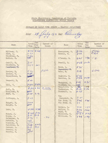
Document - Roster, State Electricity Commission of Victoria (SECV), "Rotation Roster 11th January 1971", Jan. 1971
Yields information about the rostering of crews for a specific week, which staff member undertook which shift or table, for both conductors and motormen.Typed - carbon copy - sheet foolscap size, titled "Rotation Roster 11th January 1971", dated 4th January 1971. Shows the allocation of tables to the various crews, including reallocations and those on Annual and Sick leave or work cover. See also Reg Item 3634 for a May 1969 sheet - not all names survived. Has been ruled to divide the sheet. Turnball A Hamilton N Reynolds H Thompson D Maher J Ward W Smerdon H Billman J Knight R Robe N Williams T Davies W O'Leary D Nancarrow W Courtney R Gill W Blackman M Van Rooy E Cahill M Lake E Williams R Reed A Domaschenz D Wallis I Morris A Munn B Hall R Hunt N Bird L Jeffreys A Van Rooy A McGregor D Van Oorschot Seagrave W Knight H Chambers D Davies S Mason J Tierney L Mercer A Walker L Trenfield I Powell D McMahon L Melville Tuddenham Butler K Morris R Newell W Everett D trams, tramways, rosters, personnel -
 Ballarat Tramway Museum
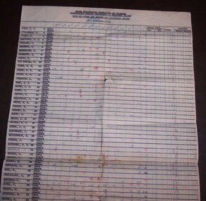
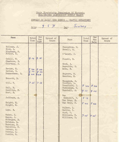
Document - List, State Electricity Commission of Victoria (SECV), "List of Overs and Shorts for Fortnight Ending 30 October 1943", 3/11/1943 12:00:00 AM
Typed carbon copy headed State Electricity Commission of Victoria, Electricity Supply Department - Ballarat Branch "List of Overs and Shorts for Fortnight Ending 30 October 1943". Typed with employee names, number, Over, Short, Fares Collected, Total and Balance of Over/Unders. Ruled in black and blue lines. Gives overs and unders for each day for each person and a total for each person and day and blue and red ink. Initialled in pencil and dated 3/11/43. Photocopies of sheet made - A3 and left hand side scanned image stitched together - see i3 (left hand half only) List of names: List of Employees– Overs and Unders return – 30/10/1943 SEC Ballarat Branch 1 Pyle NT 2 O’Donnell T 3 Prisk J 4 McDonald GJ 5 Furlong P 6 Preston H 7 McWilliam N 8 Bartlett C 9 Mason R 10 Van Berkel S 11 Young CE 12 Jolly At 13 Bodey HG 14 Johnston A 15 Ford EJ 16 Brown GC 17 Young T 18 Irving J 19 McLachlan D 20 White CF 21 Knight H 22 Bowden F 23 Scott S 24 Ellis AE 25 Sewell RW 26 Young JC 27 McCormack J 28 Eltringham E 29 Purdue A 30 Satchell GH 31 Smerdon J 32 Scruse F 33 McGann V 34 Morrow R 35 Reynolds S 36 Hall G 37 Strickland L 38 Skurrie 39 Paull J 40 Atikins B 41 Mitchell S 42 Browne M 43 Cheney J 44 Lawrence A 45 Doncaster T 46 Hudson T 47 Ritchie ME 48 Harrison J 49 Horbury T 50 Moss H 51 Tonkin P 52 Tucker V (Verna May Tucker - email of 23-9-2020 - 1914-2001 from [email protected]) 53 Denmead KI 54 Etty CC 55 Spielvogel J 56 Wightwick J 57 Jakobi EA 58 Egan V 59 Dixon DA 60 Cole M 61 Chibnall L 62 Grundell HP 63 Duke F Fox A (no number alongside)In pencil "Miss Gullock" ?? crossed out and "Mr. Munro"tickets, fares, employees, conductors, motormen, conductresses, uniforms -
 Ballarat Tramway Museum
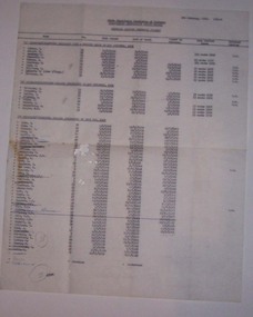
Document - List, State Electricity Commission of Victoria (SECV), "Tramways Traffic Personnel (Wages), Feb. 1970
Gives a list of names of people who worked on the Ballarat trams in the final 19 months of operations, some personal information and grade.Carbon copy of a typed list of SEC Ballarat Tramway traffic list dated 5 Feb. 1970, with hand alterations. Titled "SECV - Mid Western Electricity Supply Branch - Tramways Traffic Personnel (Wages)", gives a list of names, traffic number, position, date joined, date of birth, date passed as motorman, long service leave (taken or entitlement?) and whether a returned soldier - using letter "R.S." Three shown as "D.S." - disabled solider? List broken up into three components - "A" Motormen/Conductor Seniority List - Engaged prior to 1 Nov. 1952, - 9 Number, "B" engaged subsequent to 1 Nov. 1852 - 8 Number and "C" engaged since 30 May 1962 - 38 depending on the time. List A L Walker H Knight J Smerdon - crossed out A Turnbull - crossed out A Mercer R. Courtney W. Ward R. Williams D. Kellett - (also T/Insp.) A. Jeffreys List B D. McGregor D. Thomson I Willis D O'Leary - underlined J. Maher A. Morris D. Domaschenz R. G. Knight List C E Lake W. Maes I. Tierney B Munn N Cahill N Reynolds - crossed out W. Davies N. Hamilton L. McMahon - crossed out and (W/C) after name. J. Billman W. Nancarrow H. M. Van Oorschot W. Newell L. Bird D. Chambers H. Van Rooy H. Mannion N. Robe C. Harding - crossed out and (S/L) after name E. Van Rooy F. Edmonds - crossed out M. Blackman N. K. Alan - crossed out H. Hall J. Mason S. Davies W. F. Segrave J. F. Bolton - crossed out N. D. Hunt K. Butler - crossed out J. F. O'Brien - ruled out V. L. Gill R. K, Morris D. Everett T. Williams A. Reed R. Herauville - crossed out B. Melville I. Trenfield R. Walker - crossed out V. Thorne - crossed out B. Biddington - crossed out K. Jeffs - crossed out Hynos - in pen and crossed out Power - in pen W. Tuddenham - in pen See also list given in Reg Item 3462.1 and 3462.2 - difference in spelling for Willis = Wallis, and Power = Powell. No additional names, but not all this list names appears in the list in 3462.1Numerous crossings out of names as people left, and three additional names and numbers within circles giving sub totals and totals.personnel, sec, ballarat, crews -
 Ballarat Tramway Museum
Document - Form/s, State Electricity Commission of Victoria (SECV), "Summary of daily time sheets - Traffic Department", 1971
Form used to record a summary of the working hours of crews, showing the total hours and the hours worked when one man operation. Gives a list of names at the time when the form prepared. Also used by Ray Hall as a sheet of paper to write out the details of No. 9 run for Sundays as a reference document.Duplicated typed form, foolscap sheet, titled "Summary of daily time sheets - Traffic Department", giving name, total time, one man rate time, and spread of hours. Has a list of employee names in two columns. 3462.1 - Dated 9-5-1971 - has written out on rear of sheet, details of Sunday No. 5 run and details of shift for following week. 3462.2 - Dated 26/6/1971 - Sunday - On rear of sheets, Ray Hall - has used the sheet to write out Saturday 15 run details. On bottom of run note has written "My work for next Saturday" and "Could you be ready to go out the paper mill some time in the future at about 7pm" Names on the sheet are: (in alphabetical order on the sheet) L Walker H Knight J Smerdon A Turnbull A Mercer R. Courtney W. Ward R. Williams A. Jeffreys D. McGregor D. Thomson I Willis D O'Leary J. Maher A. Morris D. Domaschenz R. G. Knight E Lake I. Tierney N Cahill N Reynolds W. Davies N. Hamilton L. McMahon J. Billman W. Nancarrow H. M. Van Oorschot W. Newell L. Bird D. Chambers H. Van Rooy H. Mannion N. Robe E. Van Rooy M. Blackman H. Hall J. Mason S. Davies W. F. Segrave N. D. Hunt K. Butler V. L. Gill R. K, Morris D. Everett T. Williams A. Reed B. Melville I. Trenfield See above.trams, tramways, timetables, sec, ballarat, shifts, times -
 Ballarat Tramway Museum
Document - Form/s, State Electricity Commission of Victoria (SECV), "Summary of daily time sheets - Traffic Department", 1971
Form used to record a summary of the working hours of crews, showing the total hours and the hours worked when one man operation. Gives a list of names at the time when the form prepared. Also used by Jerry? as a sheet of paper to write out the details of No. 9 run for Saturdays as a reference document and noted it was last time on the Victoria St route and recorded the tramcar number.Duplicated typed form, foolscap sheet, titled "Summary of daily time sheets - Traffic Department", giving name, total time, one man rate time, and spread of hours. Has a list of employee names in two columns. Dated 28/7/1971 - Wednesday On rear of sheets, Jerry? Van Rooy - has used the sheet to write out Saturday 9 run details. Has endorsed it - "My last Vic Run on 21/8/1971" - Conductor Jerry? Van Rooy - Car No. 17" Names on the sheet are: (in alphabetical order on the sheet) L Walker H Knight J Smerdon A Turnbull A Mercer R. Courtney W. Ward R. Williams A. Jeffreys D. McGregor D. Thomson I Willis D O'Leary J. Maher A. Morris D. Domaschenz R. G. Knight E Lake I. Tierney N Cahill N Reynolds W. Davies N. Hamilton L. McMahon J. Billman W. Nancarrow H. M. Van Oorschot W. Newell L. Bird D. Chambers H. Van Rooy H. Mannion N. Robe E. Van Rooy M. Blackman N. K. Alan - crossed out H. Hall J. Mason S. Davies W. F. Segrave N. D. Hunt K. Butler V. L. Gill R. K, Morris D. Everett T. Williams A. Reed B. Melville I. Trenfield Power - in pen W. Tuddenham Photocopy of sheet made.See above.trams, tramways, timetables, sec, ballarat, shifts, times -
 Ballarat Tramway Museum
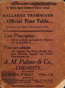
Ephemera - Ballarat, Electric Supply Co. of Vic (ESCo), "Official Time table", 1914
Timetable published by the Electric Supply Co of Victoria (ESCo) for Ballarat Tramways - dated 1/10/1914 to 30/4/1915. Provides times for each route, ticket prices, school tickets, fare box routes, fares, transfer tickets, and route colours both for day and night. Also has notes to passengers and places of interest for each route. Has contact phone numbers for the Company. Manager Mr Pringle. See item 9131 for a 1915 Winter timetable. Has many adverts - from the front page: A M Palmer Chemist Hodgson - optical Snows - department store Summerscales - postcards W E Thomas - Dentist L Casper - optician E Jermyn - feed merchant Standsfield & Smith - Decorators Briant's Red shop tea rooms A E White - tailor Ellingsen & Co - furniture Southern Cross Hotel H P Stevens & Co - fur coats Frank Williams - painter and decorator Longhurst's bread factory G Buchanan - metal ceilings Robert Hutchinson - electrical engineer and contractor G Ludbrook - furnishing undertaker A Cant - plumber, gasfitter and ironmonger Huddart Parker and Howard Smith coal merchants Precision Big 4 - motor cycles and bicycles H W Channing - Tram drivers' training school T H Richards - butcher C Ellis - furniture exchange Levecke's motor garage Frank Penhalluriack - electrical work Nankervis - store Taffy King Fred A Reed - tobacconist F & J W Gower - builder E E Hobson - decorator Walter Cornell - liver pills Irvines - wines G Warner - Ironmonger J A Reynolds - Wall papers W J Robson - leadlights Porter's - boots and shoes Holman & Fiscalini - stables and motor garage Butler & Co - blinds Mrs Kerby - clothing reseller Rose Cosmetic - H Binzer & Co Mrs Busfield - laundry Mrs J H Dogson - registry office for servants B G Tucker's Water Cure Electric Supply Co Rowlands drinks On the bottom of most pages - Sidar products and on the top the Coliseum Picture Palace. Demonstrates and ESCo timetable and provides information about fare systems and local businesses.Time table - booklet - 40 pages + brown light card covers centre stapled with tabbed or cut pages.tramways, ballarat, timetables, esco, advertisements, fares, tickets, fare boxes -
 Ballarat Tramway Museum
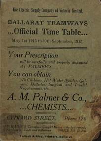
Ephemera - Ballarat, Electric Supply Co. of Vic (ESCo), "Official Time table", 1915
Timetable published by the Electric Supply Co of Victoria (ESCo) for Ballarat Tramways - dated 1/5/1915 to 30/9/1915 - winter. Provides times for each route, ticket prices, school tickets, issue and use of tokens, fares, transfer tickets, and route colours both for day and night. Also has notes to passengers and places of interest for each route. Has contact phone numbers for the Company. Manager Mr Pringle. See item 9132 for a 1914 Summer timetable. Has many adverts - from the front page: A M Palmer Chemist Hodgson - optical Snows - department store ESCo - show room in Sturt St L Casper - optician E Jermyn - feed merchant Standsfield & Smith - Decorators Briant's Red shop tea rooms A E White - tailor Ellingsen & Co - furniture Southern Cross Hotel H P Stevens & Co - fur coats Frank Williams - painter and decorator Longhurst's bread factory G Buchanan - metal ceilings Robert Hutchinson - electrical engineer and contractor G Ludbrook - furnishing undertaker A Cant - plumber, gasfitter and ironmonger Huddart Parker and Howard Smith coal merchants Precision Big 4 - motor cycles and bicycles H W Channing - Tram drivers' training school T H Richards - butcher C Ellis - furniture exchange Levecke's motor garage Frank Penhalluriack - electrical work Nankervis - store Taffy King Fred A Reed - tobacconist F & J W Gower - builder E E Hobson - decorator Walter Cornell - liver pills Irvines - wines G Warner - Ironmonger J A Reynolds - Wall papers ESCo Electric lighting Holman & Fiscalini - stables and motor garage Butler & Co - blinds Mrs Kerby - clothing reseller Rose Cosmetic - H Binzer & Co Mrs Busfield - laundry Mrs J H Dogson - registry office for servants Summerscales - stationary and postcards W J Robson - glass Porter's Boots and Shoes B G Tucker's Water Cure Electric Supply Co Rowlands drinks On the bottom of most pages - Sidar products and on the top the Coliseum Picture Palace. Demonstrates and ESCo timetable and provides information about fare systems and local businesses.Time table - booklet - 40 pages + green light card covers centre stapled with tabbed or cut pages.tramways, ballarat, timetables, esco, advertisements, fares, tickets, tokens -
 Expression Australia
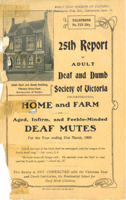
Annual Report, 25th Report of the Adult Deaf and Dumb Society of Victoria 1909
The Adult Deaf and Dumb Society of Victoria, now known as Vicdeaf, (the Victorian Deaf Society), was founded in 1884 as the Victorian Society for Promoting the Spiritual and Temporal Welfare of the Adult Deaf and Dumb. The provisional committee being Mr W Bates, Mr J M Bruce, Mr J D Gowan, Mr Edwin Newbiggin, Mr C M Officer, M. L, A., and the Rev. W. Moss. The Adult Deaf and Dumb Mission's objects were: 1. To provide the means for religious worship and instruction for the adult deaf and dumb of Victoria 2. To visit the deaf and dumb in their homes, especially when sick or in distress 3. To assist the deaf and dumb of good character in obtaining suitable employment 4. To provide technical and other education for the adult and dumb 5. To give pecuniary assistance to adult deaf and dumb who are in needThe Annual Reports of the Adult Deaf and Dumb Society are historically significant providing insight into the history of the evolving Deaf Community in Victoria. They are a annual 'snapshot' of the year with references not only to the progress of the Society but also to the significant people and events within the Deaf Community.Orange Cover, Size 21.5Hx13.5W, 76 pages (Poor Condition)thomas david gibson carmichael, f. s. grimwade, e. r. peacock, harold kent, h. sumner martin, m. l. miller, h. w. h. adeney, w. a. dickens, f. e. frewin, john m. griffiths, rev j. j. halley, s. mauger, g. g. mercy, m. l. miller, j. e. muir, f. j. rose, f. tudor, henry weedon, ernest j. d. abraham, mrs e. j. d. abraham, miss i. foster, miss a. foster, mrs f. e. frewin, mrs h. sumner martin, mrs j. e. muir, mrs r. r. paterson, mrs w. a. paterson, mrs a. wilson. mrs samuel luke, w. j. craig, john cronin, alex williamson, s. moss, m. g. b mortimer, captain olden, incorporation, blackburn, messrs ward and carleton, r. l. phillips, box hill, edward newbigin, our monthly letter, mrs w. a. paterson, e. fletcher, w. w. bass, d. robertson, w. walker, w. scott, horace reynolds, -
 Expression Australia
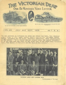
Newsletter, The Victorian Deaf - July-August-September 1928
A Bi-Monthly News Letter - Under the auspices of the Deaf Committee of the Adult Deaf and Dumb Society of Victoria'The Victorian Deaf' Newsletter is a significant publication as an historical record giving and insight into the people, activities and events of the Deaf Community in Victoria.Vol. 24 No. 7,8,9 July Aug Sep 1928, Size 37cmHx21cmW; 14 pagesh. sumner martin, e. r. peacock, edward newbigin, w. a. dickens, frank tudor, rev. j. i. halley, g. g. mercy, i. m. griffiths, h. w. h. adeney, h. bickford, j. dudley, g. vial, s. massana, ernest j. d. abraham, empson, e. burke, a. mclellan, brown, solomon moss, ruth peters, m. g. b. mortimer, j. m. johnston, r. miller, j. butterworth, p. cunningham, e. doney g. caldwell, warrie ashby, vernon griffiths, cecil griffiths, joe allen, bryon taylor, joe allen, j. e. muir, s. ferguson, walter grant, maisie reiffel, a. williamson, w. burge, myrtle groves, harold sutton, j. dickenson, david cornish, waggett, fulton, vera west, mabel ball, tennis, lacrosse, j. boortz, percy swain, e. smith, ethel dempsey, mrs frewin, empson, deaf worker's club, men's guild, deaf women's guild, british deaf conference, deaf national club, a. t. story, sam cashmore, a. a. peverill, a. h. spencer, gladys mahoney, c. h. reynolds, d. hickey, h. abbott, -
 Expression Australia
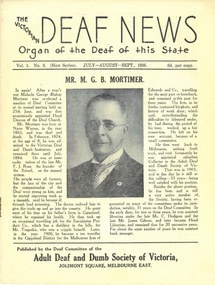
Newsletter, The Victorian Deaf News July-August-September 1936
Published by the Deaf Committee of the Adult Deaf and Dumb Society of Victoria'The Victorian Deaf News' Newsletter is a significant publication as an historical record giving and insight into the people, activities and events of the Deaf Community in Victoria.Vol. 1 No. 3 (New Series) July-August-September 1936; Size 4cmHx18.5cmW; 16 pagesmalachi george bishop mortimer, victorian deaf and dumb institution, tregaskis, c. hodgson, james gibson, harry puddy, warwick ashby, jonathon smalley, w. bartholomew, johnston, e. martin, j. boal, mrs t. peters ruth betts, r and m dow, cliff ellwood, p. johnston, nesbitt, v. buttacvoli, j. mclaurin, arthur boswell, ray cornell, s. ferguson, keage, j. brook, f. rees, j. murphy, e. stephens,williamson, dudley gooding, spinks, w. h. crush, j. o'grady, h. abbott, rennie, h. nathan, w. o'keefe, w. duncan, h. ah chow, kathleen may wilson, vosper wilson, elaine margery smith, george henry, gladys salmon, robert beatie, alice maud mary hartley, c. h. reynolds, mrs c. caughey, mrs f. h. marks, florrie tyzzer, james mills, cederic and douglas nesbitt, jean mccullough -
Port Melbourne Historical & Preservation Society
Document - Ticket, Port Melbourne Railway United Football Club, 1938
1938 Season ticket for the Port Melbourne Railway United Football Club (Port second eighteen), sponsored by the Railway Hotel in Raglan Street near North Port station.'Mr J Wilson'archibald (arch) todd, sport - australian rules football, j wilson, r frawley, thomas griffin, d l hart, l potter, e danziger, r kent, j reynolds, j le clercqq, james edward earl, michael thomas woodruff, j woodruff jnr, r powell, a summers, c ware snr, miss a frawley, w conthwaite, d mitchell, j smith, port melbourne railway united football club, port melbourne junior football club, railway club hotel, business and traders - hotels -
 City of Kingston
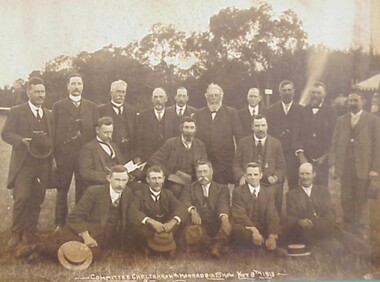
Photograph - Sepia, Percy Fairlam, Cheltenham and Moorabbin Show Committee, 1913
This image shows the group of men who formed the committee for the Cheltenham and Moorabbin Show. The men have been identified as: Seated (left to right) Mr R L Amess (Hon Sec), Cr George Brownfield (President), Mr Harold Irwin (Hon Treasurer). Standing (left to right) Messrs P White, F Wilson, E T Fenny, J H Butler, G Wells, R Mills, H F North, G T Allnutt, J Shields, F Reynolds. Seated (in front) Messrs F Moorhouse, E Marriott, A Hewitt, CD Scullin, R Potts.The Moorabbin Horticultural, Poultry and Dog Society Show became an annual event in 1898, following a 35 year tradition of Brighton Horticultural, Poultry and Dog Society annual exhibition. Sepia toned image of the Committee of Cheltenham and Moorabbin Show. Five men are seated on the ground in the front row, with hats resting on their knees or on the ground. Three men are, presumably, seated behind them on chairs, with the man on the left reading a document or book. Ten men are standing at the rear. -
Federation University Historical Collection
Booklet, J.A. Hoskin & Son, Ballarat School of Mines Students' Magazine, 1945, 1945
List of Full Course Students' 1945, Editorial, Editor's Notes, News and Notes, End of the War 1939-1945, Obituary, The Literary Society, The Chemical Nature of Women, Fumes from the Lab, Forests - Our Asset and Responsibility, Arts & Crafts Gossip, Sports, Commercial Notes, The Junior TechsMaroon cover with, blue, green and gold lettering, soft covered magazine of 72 pages including advertisements. Artwork Mr Calder - By Eda Woodfield Miss Williams - By Ruth Mole Basil - By Beatrice Burgess Roy - By Eda Woodfield Mac - By Gweneth Speirs Joll - By Marjorie Gray Doug - By Ruth Mole View from the cutters hut - By Marion Beckwith Mr Fairbank - By Ruth Mole Perc - By Ruth Mole Peter - By Eda Woodfield Fritz - By Joan Walter On the track to the cutter's hut - By Joan Walter The cutter's hut - By Ruth Mole Gertie - By Marjorie Gray Bombhead - By Ruth Mole Gwen - By Francis Duffy Marje - By Ruth Mole David - By Joan Walter Skeeter - By Joan Walter Ewan - By Ruth Mole Blue - By Neville Reeve Stanley - By Joan Walter George - By Joan Walter Vic - By Beatrice Burgess Gladys - By Eda Woodfield Olwyn - By Beatrice Burgess Valda - By Beatrice Burgess Betty - By Eda Woodfield June - By Eda Woodfield Stella - By Beatrice Burgess Verna - By Eda Woodfield Valerie - By Eda Woodfield June - By Beatrice Burgess Dorothy - By Joan Walter Beryl - By Joan Walter Noreen - By Ruth Mole Pat - By Joan Walter Valma - By Eda Woodfield Graham - By Gweneth Speirs Johnny - By Joan Walter Charlie - By Beatrice Burgess Raynor - By Marjorie Gray George - By Marjorie Gray Darkie - By Ruth Mole Duck - By Beatrice Burgess Robert - By Ruth Mole William - By Gweneth Speirs Basil - By Joan Walter Wilson - By Joan Walter Schoolbeck - By Ruth Mole Duck Weed - By Eda Woodfield Bas - By Beatrice Burgess Albert - By Ruth Mole ballarat school of mines, magazine, g. curtis, p. edmonds, kevin j. whiter, david t. coburn, peter j. wilson, john k. leicht, douglas d.g. dean, frank d. daykin, grace lawry, p. maloney, j. mckenzie, percival d. fisher, stanley s. parker, beatrice e. burgess, roy e. mawby, roma sudoltz, peter h. marxsen, lois reynolds, robert j. mckenzie, w. coad, marion a. beckwith, john g. procter, gweneth. speirs, neville f. reeve, dr pound, c. fairbank, f. g. procter, jeanette perkins, john w. jolly, m. berlyn, c. g. fairbank, bill f. carroll, marjorie gray, f. n. reeve, joan waller, winifred m. beckwith, isobel murfett, frank daykin, joy martin, max coward, jack henderson, joe wilkinson, alan wilson, muriel harland, m. fogarty, sylvia williams, t. r. thomas, john p. l. gibbs, t. mccartney, a. s. richards, p. crosby, h. middlin, mr cornell, lois kinnersley, margaret murrell, ouida worthington, i. murfett, ruby gladman, john m. blainey, mina gallie, miss darby, p. moloney, v. eva, lester w. roffey, robert f. swales, john e. ambrosio, mr hillman, neville r. morton, basil j. marshall, lloyd lehmann, lindsay s. pattenden, john middlin, alfred e. temby, a. hyett, willaim g. young, kingsley r. bremmer, william j. hewitt, geoffrey f. stevens, n. black, lucy cooper, valma overall, evelyn ditchfield, b. lancaster, miriam horsey, lorraine saunders, n. hoffman, audrey fry, robert j. murell, colin a. bell, ewan c. jones, d. powell, william j. llewllyn, kenneth s. lindsay, nola dridan, patricia gleeson, winifred stevens, mary cummins, b. sherritt, alison johnson, b. conway, b. vallins, k. dowall, m. grinham, k. eberhard, c. lea, k. george, a. coad, c. eltringham, w. allan, m. silvey, f. jacobson, l. clifton, r. sargent, w. caldow, g. pyke, g. bergin, k. dean, r. bennett, k. hoffman, a. kerr, h. sealey, d. mcconville, p. nunn, d. halson, l. frichot, g. smith, m. mcdonald, w. hon, r. irving, l. drake, c. gedye, g. jukes, a. new, a. smith, k. weybury, c. wilson, p. banfield, a. hughes, g. yeoman, eda woodfield, francis duffy -
 Bendigo Historical Society Inc.
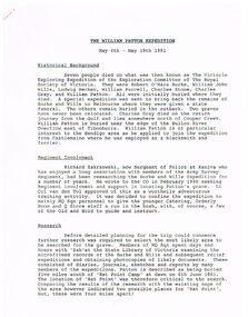
Document - THE WILLIAM PATTON Burke and Wills EXPEDITION MAY 4 - 19 1991
Typed notes on an expedition by Army personnel and Richard Zakrzewski to find the grave of William Patton who was buried near the edge of the Bulloo River Overflow east of Tibooburra. He was a member of the Burke and Wills Party. Notes mention planning for the expedition and what they did while they were there. C. E. Burgess WO2, the author of the notes.document, the william patton expedition may 4 - 19 1991, the victoria exploring expedition of the exploration committee of the royal society of victoria, robert o'hara burke, william john wills, ludwig becker, william purcell, charles stone, charles gray, william patton, richard zakrzewski, army survey regiment, burke and wills expedition, lt col van den tol, state library of victoria, land information centre bathurst, capt. coulthard, wo1 slater, wo2 burgess, sgt de grauw, lcpl blake, capt cuskelly, wo1 gillies, ssgt sustart, cpl colde, cpl south, lcpl northausen, spr linwood, wo2 graham, ssgt gowers, sgt marshall, cpl doyle, cfn ellis, spr reynolds, spr hilbig, pte mckersie, 10/27 rsar, clifton downs homestead, gwen smith, william patton memorial -
 Eltham District Historical Society Inc
Document - Folder, Orford family
The Orford family, a pioneer family remained continuously living and working in Eltham for 170 years from 1854 to 2024. James and Sarah Orford arrived in Sydney in 1839 aboard the ship “Orestes”; they had several children there before settling in Eltham in 1854. Three children, James Mathias, Sarah Amelia and Thomas Henry initially remained in the Eltham area. James eventually moved to Brunswick. Sarah married Arthur Butler Young and finally lived in Bunyip. Thomas who was six years old when the family arrived in 1854 remained in Eltham, married Helen Logan who died, leaving a large family. They lived in a slab hut by the Yarra at Laughing Waters and Thomas managed the Panton Park Estate, a selection owned by Magistrate Thomas Panton. Thomas’s son, Ernest Orford was born 1892 at Pitt Street, Eltham and also lived his entire life in Eltham working as a labourer, orchardist and later as a gardener and grounds keeper for Sir William Irvine, a former Chief Justice and Premier of Victoria. Ernest married Kate Thomas; their two sons Ron and Doug stayed in the area. Another of Thomas' sons, Arthur, also lived in Eltham. Four Orford generations attended Eltham schools. Doug Orford was born on the kitchen table (reference, son Ted Orford) of the family home at the corner of Reynolds Road and Mount Pleasant Road. Doug married Gwen and they established a family however Gwen died at a young age from cancer. Doug eventually remarried another Gwen and they lived for several decades in Napoleon Street, Eltham. Doug was actively involved in EDHS over many years, including serving as a committee member and vice president. Contributions by Doug and Gwen (Treasurer/Membership Secretary), his wife, assisted EDHS to continue to develop as a not-for-profit group intent on promoting and preserving our local history. Both Doug and Gwen were made Life Members of EDHS. They also acted as EDHS delegates to the Eastern Region of Historical Societies. His significant work with assisting to establish our valued Local History Centre helped develop our home base and supported the continued growth of our society. Doug’s local knowledge, suggestions and family connections were highly valued, Until recent times, he continued to regularly attend our Collections Team workshops providing his insights and historical information about photographs and society records. Doug died peacefully July 8, 2024, and represents the last link in the Orford Eltham chain which spanned 170 years. His funeral was held Thursday, July 18, 2024, at Le Pine Funerals, 848 Main Road, Eltham. Contents: Typed notes, no date: Memories of Ernest Orford [taped 1979] about his school days. Handwritten notes, no date: History of Ernie Orford Typed notes, no date: History of Thomas Henry Orford and family. Photocopy: Shire of Eltham General Rate Receipts. Received from D Orford 7 June 1923 and Received from E F Orford, 4 August 1924. Letter, no date: Nillumbik Shire to Russell Yeoman, Gwen Orford to receive Volunteer Recognition Award. Newsletter article: "The Orford Family, Eltham", Shire of Eltham Historical Society, No.80 September 1991. History of Orford family. Handwritten notes: 21 March 2011, genealogy of George Orford. On reverse Melways map makred with Orford and other land ownerships. Newspaper advertisement, 21 March 2011: "264 Reynolds Road, South Eltham", property for sale [land in ownership of Orford family]. Letter: St Margaret's Anglican Church Eltham to Doug Orford, 17 November 2011, Extracts from church records relative to Orford family. Newspaper article: "Timely facelift at war memorials', Diamond Valley Leader, 30 April 2024, Nillumbik war memorial will have some work and a bronze plaque will be installed at the Eltham Avenue of Honour, Wingrove Park; photograph of Doug Orford Newsletter item: "Welcome home medal", Eltham District Historical Society newsletter no.216 May 2014, World War I two 'Welcome Home Medals' in ownership of local men, being Harry Gilham and Doug Orford. Order of Service, Le Pine Funerals (Eltham), In Loving Memory of Douglas Frederick Orford 22nd August 1929 - 8th July 2024 Doug Orford Reminiscences (2002) in conjunction with Jock Read and Peter Bassett Smith; 4 pages - 3 typed, 1 handwritten possibly transcribed from an audio tape recording (location unknown). New word file and associated pdf created [\Dropbox\EDHS DATA\DOCUMENTS\COLLECTION CATALOGUE DOCUMENTS AND PDFs\2-2 Family Folders\EDHS_06110-2 Doug Orford reminiscences 2002.docx - 1 April 2025]Newspaper clippings, A4 photocopies, etcdoug orford, harry gilham, welcome home medal, eltham avenue of honour, nillumbik war memorial, wingrove park, henry dendy, alfred armstrong, james orford, 264 reynolds road south eltham, george orford, george joseph orford, maryanne george joseph, thomas henry orford, ernest orford, e f orford, eltham cemetery, helen orford, joseph panton, panton park, gordon lyon, banyule estate heidelberg, james matthias orford, wurundjeri, constable peter lawlor, george hill, franklin street eltham, ronald orford, eltham primary school, john brown, robert gamble school inspector, sarah orford, mary ann orford, james mathias orford, sarah amelia orford, james peet, arthur butler young, watsons creek victoria, kangaroo ground victoria, helen logan, william orford, jane orford, arthur orford, frederick orford, florrie orford, victor orford, chem orford, sunnymede eltham, panton hill estate, sir william irvine, gordon lyons, kate thomas, north eltham gospel church, harold clapp, eltham cricket club, research primary school, dalton street school eltham, keith banks, betty banks, benjamine boyd, laughing waters road eltham, freddie gilsinen, douglas frederick orford, eltham district historical society, funeral service, le pine funeral home, life member, order of service, 1934 flood, 1939 bushfires, alcock & pierce, ansell, associated schools sports, blacksmith shop, boakes, bridge street, bryce family, bullock track, butcher, catholic church, cliff lester, cliffy green, daisy smith, dave lyon, diamond creek, diana bassett smith, dick tooth, dr. frank may, eltham higher elementary school, ernie andrew, fire station, flower stall, fodder business, fruit shop, furniture store, gahan family, garni burges, greensborough, harold norman, harry hawker, hat factory, hawker & owen, hay and com store, henry hawker, henry street, j .harry butherway, jack burgoyne, jack ryan, jock read, john lyon, junk yard, kevin gahan, kilpatricks, len parsons, lyon family, machine factory, mc leans, memorial, metery road, miss reynolds, monteith 's bus, mr. gadd, mrs. bird, mrs. morrison, napoleon street, peter bassett smith, peter's gahan, plenty river, plumridge, produce store, public hall, rechabite hall, reynolds road, roger bird, rutter family, ryan family, shoe factory., staffs produce store, studley cairn gahan, sweeneys lane, swimming pool, taylor street, tennis court, warren family, wooden bridge, yarra brae road -
 Eltham District Historical Society Inc
Document - Archive Box, 1570 Main Road, Research (Research Primary School)
Contents: 1. Andrew Lemon's Working File of Return to Research Andrew Lemon's Working File for his 1989 book, “Return to Research: A Centenary History of Research Primary School" (EDHS_00867). Includes a disassembled copy of the book. (All other documentation and photos passed to Research Primary School 3 September 2013) 1.1. EDHS_05004 - Cassette Tape of "Afternoon Tea with Senior Residents Nov 1st 1984" Reminiscences, chit chat and banter between group of senior citizens at an afternoon tea held for them at Research Primary School. 1.2. School Register 1935-1994 (Box 1) Photocopy of Research Primary School register from 1935 to 1994 (originals held at school) From 1994 onwards registrations were made online via the Education Department CASES system. 1.3. School Register A-Z 1935-1987 (Box 2) Computer print-out of alphabetized register 1935-87 (Research Primary School) (Done by David and Sue Grigg in 1987 from the register) Contains some extra details/corrections/current addresses Plus disks containing this data (not housed in box – there is a separate floppy disc box containing several 5 ¾” and 3 ½” floppy disks which are not readable as no hardware/software to support) 1.4. Research Locality History (Yellow Folder 1) Research Locality History Newspaper cuttings, Photocopies etc Collection for Research Primary School History 1989 Contents • 3 x photocopies (A3) regarding sale of Raglan Estate, Research [2 x A3 and 1 x composite A3 colour photocopy] • Souvenir Map of area with pictures of historical items and wild life - A Visitor's Guide Map; ELTHAM, WARRANDYTE and Environs (see also EDHS_01633-1) • EO article 26 Mar 1897 "Research State School picnic expedition to Mordialloc" • TA article 25 Jul 30" Research Affairs" plus an add for J Ingram's Research Bakery • DVN articles 14 Jan 69 (2 pages) "Research Fire Victim (Bill Pelling) still in hospital" • DVN 14 Jan 69 Page of Deaths, In Memories, Obituaries, Church Notices, Public Notices and Notices • Age article 24 Jan 84 "Eltham before the Mud Bricks" • DVN article 21 Oct 86 "Facing Good and Bad Times with enthusiasm - Keith Maxwell" • DVN article 29 Aug 87 "Eltham - the historic haven" • DVN article 25 Aug 87 "Eltham - a piece of living history, (the historic haven cont…)" • DVN article 20 Oct 87 "When push bikes were made for touring - Sam Howard" • 6 x pages of what appear to be various student's workbooks/ projects from 1944/45 era • ''They lost their homes- Historical places go at Research" plus other articles on fires 8 Jan 69 [Located in Folder 2] • DVN articles 23 Oct 84 "Centenary Plans" & Folklore surrounds Research township" [Located in Folder 2] • DVN article 23 Sep 86 "The teacher who had cut cane but never used one" Frank Sheehan (3 copies) [Located in Folder 2] • 2 x copies of booklet "Memories of Eltham" [Located in Folder 3] • Photocopy of subdivision Parish of Nillumbik [Located in Folder 4] DVN = Diamond Valley News, EO = Evelyn Observer TA= The Advertiser 1.5. Copies of items held by Public Records Office Victoria (Yellow Folder 2) Copies of items held by Public Records Office Photos and display items from Research Primary School Centenary August 19, 1989 • Laminated photocopy: “State School No. 2959, Copy of the above school property,” signed Henry L. Cole 18.6.91 • Photocopy: Petition for a school at Research, 13/11/1888; Public Record Office Victoria School Building File – School 2959 CUPRS 795/1717 • Photocopy: Negotiation to buy school site – part of Allotment 2, owned by the West family (copy attached to letter) 15/1/1890; Public Record Office Victoria School Building File – School 2959 CUPRS 795/1717 • Photocopy: Frank Scott, Head Teacher Research 1904-1907, letter of explanation (first page) to Department re poor results by pupils at the school, 24/8/1907; Public Record Office Victoria School Building File – 640 / School 2959 • Photocopy: Anton Brinkkotter’s Certificate for Regular Attendance 1908 (This was ‘traded in’ in 1911 for a certificate to mark six years without missing a day of school; Public Record Office Victoria School Building File – 640 / School 2959 for 1911 • Photocopy: Education Department Memorandum 1949 re need for extensions and improvements; Public Record Office Victoria School Building File – 795 / School 2959 • Photocopy: Looking to the future about expanding site for additional land for play space, 1950, Education Department Inspector to Department; Public Record Office Victoria School Building File – 795 / School 2959 • Photocopy (laminated, 2 sheets) First School Fire -1953 copy of Police Report. The old school building was badly damaged but repaired. It burnt down in 1976; Public Record Office Victoria School Building File – 795 / School 2959 • Photocopy: The Argus (28 July 1953) & the (Sun 28 July 1953) Two newspaper cuttings and notes re school fire 1953; Public Record Office Victoria School Building File – / School 2959 • Photocopy: Head Teacher Reg Jackman expresses concern to Education Department about conditions as he takes charge of Research State School, 1957; Public Record Office Victoria School Building File – 640 / School 2959 • Photo print (x2) of Education Department Qualifications and Certificates, Lyla Dickson, State School. (1) Print missing (2) Education department Victoria, Merit Certificate, This is to certify that Lyla Dickson has completed satisfactorily the Course of Study presented for the Eight Grade in Elementary Schools, dated at research Elementary School, this 20th day of November A.D. 1923 • Copy of original photo owned by Nell Howard “Fancy dress night in the school house – 1920s”, black and white print, 10.5 x 18 cm, attached to A4 photocopy of photo with names inscribed10.5 x 18 cm • Copy of original photo (stamped Reynolds Collection), black and white print, 24.5 x 16 cm, attached to paper sheet 37.6 x 25.5 cm, inscribed “Miss Doney” and “Elizabeth Doney and her family owned and ran Research’s Store and Post Office for many years after buying the property from the wests. This land surrounded the school site and includes today’s [1989] Kanandah Ct, Raglan St and shops” • Black and white photo print, 20 x 25 cm, Reconstruction of Main Road in front of Research Primary School, August 1989 • Black and white photo print, 20 x 25 cm, Eastern end of old oval, Research Primary School, 1989 • Black and white photo print, 20 x 25 cm, Portable Buildings, Research Primary School, 1989 • Black and white photo print, 20 x 25 cm, Gymnasium, Research Primary School, 1989 • Black and white photo print, 20 x 25 cm, Administrative Art Building, Research Primary School, c.1989 • Black and white photo print, 20 x 25 cm, Betty Kicker, Cleaner at Research Primary School, c.1989. Betty worked at the school from early 1970s to 1990s 1.6. ‘Memories of Research 1951-1968’ (Yellow Folder 3) Interview by Sue Grigg of Florence Egglestone for publication in Return to Research. Original handwritten notes, ‘Memories of Research 1951-1968’ 1.7. Centenary Committee Minutes & Newsletters (Yellow Folder 4) Centenary Committee Minutes and Newsletters Information regarding attendance of 100th anniversary including lists of staff contact details 1983-1986 Request (1985) to Shire of Eltham Historical Society for information and memorabilia • Letter: Ann Bouchier, Convenor – Centenary Committee, Research Primary School to R. Yeoman, Shire of Eltham Historical Society, 15 October 1985; enquiring about memorabilia etc that could be used in a proposed compilation on the “History of the School.” • Minutes of Meeting, Centenary Sub-Committee, Research Primary School Council o 17 June 1985. Also includes a list of general aim, specific aims and methods for the research Primary School Centenary - 1989 o 15 October 1985. o 17 September 1986. o 20 August 1987. o 2 May 1988. o 9 June 1988. o 22 August 1988. o 12 October 1988. o 24 November 1988. o 17 April 1989. o 24 July 1989. • Outline of Historical Events 1884-1954 (3 pages) • Centenary Newsletters o Number 1 (1989) o Number 2 (1989) o Number 3 (1989) o Newsletter (c. Aug. 1989) • Information re attendance of 100th Anniversary, Research Primary School, 19 August 1989 o Research Primary School – Staff 1984 (includes Name, Address, Telephone) o Research Primary School – Staff 1985 (includes Name, Address, Telephone) o Research Primary School – Staff 1986 (includes Name, Address, Telephone) o Emergency Teacher List 1983 o Emergency Teacher List 1986 o Previous teachers 1984 on • Quotation No. 733, Major Graphics for Engraved Brass Commemorative Plaque for opening of School Gymnasium • Centenary Invitation; Program and Souvenir and Chicken & Champagne Supper order forms • Various Centenary Invitation lists with notations, and various returned RSVPs • Centenary Program and map • Photocopy: 11 pages typed with hand corrections, draft manuscript for Andrew Lemon’s book, Return to Research (pages 13-24) • Bulletin: “I’m an Aussie” Week – 15th-19th April 10/4/85 • Bulletin: Research Centenary 26/4/88 • Bulletin: Official Centenary Logo For Research Primary School 15/12/88 • Bulletin: Centenary School Activity – “Colonial School” 23/5/89 • Bulletin: Centenary Activity Days – Monday, 14th August, Tuesday, 15th August 7/8/89 • Advertisement: A3 photocopy, Centenary Bush Dance, Sat. 4th March featuring “Paradiddle” Bush Band • Photocopy Master: Invitation (blank) to attend “Return to Research” celebration and Official Opening of the School Gymnasium on Saturday, August 19th from 1.00p.m. to 5.00p.m. and attached RSVP (also includes yellow paper sample -blank) • Photocopy Master: Tickets for Centenary Chicken & Champagne Supper, Friday, 18th August 1989, 7.30p.m., $5.00 per head (2 yellow paper samples marked on reverse ‘13’ and ‘55’) • Photocopy Master: Centenary Gift Donated by slips including multiple blank samples • Promotional Notices o Letter, Robert Wenn, Principal, 29 November 1988 for placement of “HELP WANTED” in Public Notices of The Age o Information provided to Ian Reid Real Estate Agent for Board to promote Centenary Bush Dance Paradiddle Band, Saturday 4 March 1989 o Notice Board promoting ‘Old Time’ Gala Fete Saturday 17 June 1989 o Letter, Robert Wenn, Principal, 24 August 1989 to Ian Reid Real Estate thanking for support of Centenary celebration and successful book launch and seeking further support for next event being school musical production “Spirit of Research” written by Andrew Lemon to be performed December 7th. 1.8. 1989 Research Primary School Centenary Visitors Register and Sue Grigg Correspondence (Red Folder) Sue Grigg’s Folder of Visitors to 1989 Centenary Celebrations and correspondence to Sue Grigg as organiser of Centenary Celebrations • 22 A3 Sheets of 1989 Research Primary School Centenary Visitors Register (approx. 238 entries) • Correspondence to Sue Grigg as Organizer of Centenary Celebrations o Trace B? – Ingram, Dunolly, 30 January 1990 re photo of Ingrams Road. Includes hand drawn map of various buildings on Ingrams Road. Also black and white print copy (12.5 x 17.5 cm) of photo of Ingrams and Main Road (possibly one sent to her) – see SEPP_0511 o Barbara Booth (nee Coles); thanks for wonderful celebration o Len and Marlene Parsons, 21 August 1989 o Mrs R. Towers, n.d. thanks for school photo ordered o Winifred L. Lade, 7 August 1989, gg grandparents William and Mary Crozier, daughter Sarah married Thomas Baillie (her g grandparents). Thomas Baillie was one of the petitioners for the school o Winifred L. Lade, n.d., thanks for photo and map o Carol Mathews, thanks for celebrations and payments for photos. Written on reverse of Sue Grigg’s letter to her of 19 September 1989 o Kenneth Ingram, Monday 14th, thanks for invitation but unable to attend • Photo of Ingrams and Main Road 1.9. Student Photos c.1970s (Buff Folder 1) [Not in Archive Box] Quantity of photos of students taken by Mrs Avril Baker (Staff Member) In 1970s 1.10. 1989 Centenary Questionnaires (Buff Folder 2) Research Primary School, 1989 Centenary Questionnaires from school families (approx. 190 responses) 1.11. Archive and Class Photos 1890s-1961 (Buff Folder 3) • Archive photographs of Research and District; 10 x 15 cm prints and digital files on thumb drive (copied to Collection catalogue) o RPS 1- Henry Cole Head Teacher 1891 to 1903. Photo from Mrs E. Williams o RPS 2 - Mary Jane Cole with eldest daughter Doris c 1905 o RPS 3 - Wedding Photo Mary Jane Rodda and Henry Cole o RPS 4 - Joseph Rodda of Chun Grove, Research o RPS 5 - Walter Rodda 1917 son of Joseph Rodda o RPS 6- Henry Cole and Pupils 1897 (Reynolds Collection) o RPS 7 - Elizabeth Doney (Reynolds Collections) o RPS 8 - Doney's Store early 1960's o RPS 9 - Main Road Research to Left, lngrams Road to Right o RPS 10- Main Road Eltham from Griggs family o RPS 11- Eltham near Station from Griggs family o RPS 12 - The Main Street Eltham from Griggs family (Rose Series 4344) o RPS 13 - The Rev and Mrs Thomas Cole. Parents of Henry Cole o RPS 14- Henry Cole as a boy with older brother Tom. From Mrs E. Williams. o RPS 15- Mary Jane Rodda as Mrs Henry Cole, Sewing Mistress Research State School 1891 to 1897 o RPS 16 - Etta Rodda Sewing Mistress Research State School 1897 -1904 o RPS 17 - Frederick Rodda son of Joseph Rodda o RPS 18- Bush Fires 1963 o RPS 19 - The view to the northeast from the top of the School Grounds 1989 o RPS 20- Edwin Rodda son of Joseph Rodda • Class and Staff photos, some with lists and names for identification [see separate folder of digital files – no hard copies in folder] Decade Years Represented 1890-1899 1897 1900-1909 1900, 1904 1910-1919 1910 1920-1929 1922, 1925 1930-1939 1930, 1932, 1937 1940-1949 1940, 1942 1950-1959 1950, 1951, 1952, 1953, 1954, 1955, 1956, 1957, 1958 1960-1969 1960, 1961, 1969 1970-1979 1970, 1971, 1972, 1973, 1975, 1976, 1977, 1978, 1979 Staff: 1971, 1976, 1978, 1979 1980-1989 1980, 1981, 1982, 1983, 1984, 1985, 1986, 1987, 1988, 1989 Staff: 1981, 1982, 1985, 1986, 1987, 1988, 1989 1990-1999 1990, 1991, 1994, 1995, 1996, 1997, 1998, 1999 Staff: 1990, 1994, 1995, 1996, 1998, 1999 2000-2009 2000, 2001, 2002, 2003, 2004, 2005, 2006, 2007, 2008, 2009 Staff: 2000, 2002, 2003, 2004, 2005, 2006, 2007, 2008, 2009 2010-2019 2010, 2011, 2012, 2013, 2014 Staff: 2010, 2011, 2012, 2013, 2014 • Class names; 4 pages handwritten and 2 numbered diagrams of Class names: o 1942 whole school o 1975 Grade 1 o 1976 Grade 2-3 o 1977 Grade 3 o 1978 Grade 4 o 1979 Grade 5 o 1980 Grade 6 • Negatives of photographs, 1 x roll of 36 and contact prints, copied at or for the Centenary 1989 o Neg. S – same as Neg. 27 o Neg. 1 – 1961 2/3 o Neg. 2 – 1960 5/6 o Neg. 3 – 1960 2/3 o Neg. 4 – 1960 Prep o Neg. 5 – 1957 Gr 2 o Neg. 6 – 1956 1A & II o Neg. 7 – Prep & I o Neg. 8 - 1955 o Neg. 9 – 1955 I & II o Neg. 10 – 1958 Gr II o Neg. 11 - 1960 3A & 4 o Neg. 12 – 1961 4 & 5 o Neg. 13 – same as Neg. 17 o Neg. 14 - 1925 o Neg. 15 - 1930 o Neg. 16 - 1942 o Neg. 17 – 1927 whole school o Neg. 18 - 1937 o Neg. 19 - 1932 o Neg. 20 - 1953 o Neg. 21 – 1951 Prep - 3 o Neg. 22 - 1954 o Neg. 23 - 1952 o Neg. 24 – Gr 4-7 o Neg. 25 – 1956 V & VI o Neg. 26 - 1940 o Neg. 27 – 1961 Gr 1 & 2 o Neg. 28 – SEPP_0610 (and 12.5 x 17.5 cm black and white print) o Neg. 29 – SEPP_0611 (and 12.5 x 17.5 cm black and white print) o Neg. 30 – SEPP_0612 o Neg. 31 – SEPP_0516 o Neg. 32 – SEPP_0509 (and 12.5 x 17.5 cm black and white print) o Neg. 33 – SEPP_0510 o Neg. 34 – SEPP_0511 o Neg. 35 – SEPP_0513 • Requests for copies of photos including explanation from Andrew Lemon that copies were made by camera of original photos provided by their owners • Colour photo print (copy of original), 12.5 x 17.5 cm, Doney’s Store, Main Road, Research, early 1960s including black and white photocopy of original print showing slightly wider field of view • Colour photo print, 10 x 15 cm, marked on reverse “19A” and “1 copy”, Aerial view of Research Primary School, c.1989 • Black and white print, 9 x 9 cm, Burnt out houses Ingrams Road Research near Cassell's Road after 1963 bushfire • Black and white print, 9 x 9 cm, Sight see-ers Ingrams Road Research near Cassell's Road after 1963 bushfire • Black and white photo print (copy of original), 20 x 25 cm, A memento of the Eltham Higher Elementary School Past Pupils Association Ball, Research Hall, 9 October 1966; inscribed and stamped on reverse “Reynolds Collection” • Colour photo print (copy of original), Kodak A4 photo paper, Pittaways cnr Main Road and Parsons Road c.1968 • Colour photo print (copy of original), Kodak A4 photo paper, Pittaways cnr Main Road and Parsons Road, my dad’s boat, c.1970, • Black and white photocopies of photos from Reynolds Collection o EDHS_00799-20 - The Research Hotel o EDHS_00799-22 - General Store, Research o EDHS_00799-27 – Plumtree Creek, Blashik family home, Ingrams Road o EDHS_00799-30 - Research o EDHS_00799-34 - Research Gully Bridge, Research Gully Road, c.1895 o EDHS_00799-35 - Research o EDHS_00799-37 - Waiting for the taxi-bus, Main Road, Research o SEPP_0524 - A Bush Home - Research, Vic.. 1.12. Research Primary School Centenary 1989 Display Photos (Buff Folder 4) 7 display pages, 37.8 x 25.5 cm, with 10 x 15 cm sepia coloured reproduction photographs attached and handwritten notations [some have come loose or missing] • Henry Cole, Head Teacher, Research, 1891-1903 o RPS-14 Henry Cole as a boy with his older brother Tom o 2 photos as a young man (missing) • Rodda Family, Jospeh B Rodda and two of his daughters o RPS-4 Joseph Rodda of Chun Grove Research o RPS-15 Mary Jane Rodda as Mrs Henry Cole, Sewing Mistress, Research State School, 1891-1897 o RPS-16 Ettie Rodda, Sewing Mistress, Research State School, 1897-1904 • Cole Family o Henry Cole, Head Teacher, 1891-1903 o RPS-3 Wedding photo 1894, Mary Jane Rodda and Henry Cole (missing) o RPS-2 Mary Jane Cole with eldest daughter, Doris, c.1905 (missing) • Cole Family; The Rev. and Mrs Thomas Cole, parents of Henry Cole o Rev. Thomas Cole o Mrs Thomas Cole o RPS-13 The Rev & Mrs Thomas Cole parents of Henry Cole • Cole Family o Reg Cole, O.B.E., as Town Clerk of Hobart meeting Queen Elizabeth and Prince Phillip, 1954. HJR (Reg) Cole was the eldest child of Henry and Mary Jane Cole, and was a pupil at Research State School c.1900-1903 • Sons of Joseph B. Rodda of ‘Chune Grove’, Research o RPS-17 Frederick Rodda o RPS-20 Edwin Rodda o RPS-5 Walter Rodda, 1917 • The Aqueduct (20 x 25 cm black and white reproduction print); built for opening in 1891 to take water from Maroondah to Reservoir (Reynolds Collection) 1.13. Class Photos (photocopies) - with names identified at Centenary 1989 (Buff Folder 5) [Not in Archive Box] Research Primary School- Class Photos (photocopies) -with names identified at Centenary 1989 1964 - 1984 1.14. News Paper Cuttings (Folder 2) News Paper Cuttings • Diamond Valley News - 23 Oct 1984-Centenary Plans - Folklore surrounding Research Township • Diamond Valley News 23 September 1986 - The Teacher who had cut can but never used one (4 copies) • Diamond Valley News- 20 October 1987 - When push bikes were made for touring (2 copies) • Diamond Valley News-14 January 1969 - They lost their homes (Historical places go at Research) • Diamond Valley News- 14 January 1969 - Bush Havoc ( 10 houses burnt at Warrandyte) • The Age - 24 January 1984- Eltham before the Mud Brick • Diamond Valley News - 14 January 1969- First Fire Call came at 10:25 am • Diamond Valley News - 14 January 1969 - Black Wednesday • The Advertiser- 25 July 1930- Research Affairs and add Research Bakery • Evelyn Observer - 26 March 1897 - Research State School part of a district schools expedition to Mordialloc (2 copies) • Diamond Valley News- 21 October 1986- Facing good and bad times with enthusiasm • Diamond Valley News- 14 January 1969 -Obituary David Leslie Mitchener • Diamond Valley News- 25 August 1987 - Eltham - the historic haven (2 copies) • Diamond Valley News-14 January 1969 - Research fire victim still in hospital 1.15. Reminiscences (Folder 3) • Memories of Eltham (Multiple authors) (2 copies) • List of names of children who attended Research Primary School as recalled by Kenneth Ingram (b.1907) provided in 1987 by his niece Grace Burrows (nee Ingram) including names of students and teachers she recalled from her time at school 1936-1941 • Photocopy of Interview by Sue Grigg of Florence Egglestone for publication in Return to Research, ‘Memories of Research 1951-1968’. [Original handwritten version in Yellow Folder 3.] 1.16. School Site and Buildings (Folder 4) • 3 x photocopies of photos of early school building • Raglan Estate Research • Plan of subdivisions Research 1920s • 1981 Education Department Building Operation process to be followed in the event of criminal damage 1.17. School Historical Documents (Folder 5) School Historical Documents • Certificate of Merit Ernest Reynolds • Inventory of Books and Equipment 1891 • Letter from Teacher Frank Scott explain poor results • Letter from Henry Cole recommending appointment of Mary Jane Rodda as Sewing Mistress • Special Certificate for Regular Attendance Anton Brinkkotter (2 copies • Certificate of Merit Anton Brinkkotter 1911 • Merit Certificate Lyla Dickson 1922 • Special Certificate for Regular Attendance Margery Palmer 1927 • Letter from Head teacher Reg Jackman 1957 • Petition to Education Dept 1884 from Research Gully to open a school • Joseph Mankey's complaints about temporary classroom 1890 • Research 1890 - Plan of one acre site to be purchased by education Dept for permanent school • List of buildings and dates • Need for extensions and improvements 1949 • Looking to the Future 1950 • Negotiations to buy school site 1890 2. Magenta Folio 1. USB drive containing • Class photos 1897-2014 • Class photo names • List of head teachers/Principals 1989-2014 • List of Infant Productions 2001-2010 • School photo names typed up identified at centenary reunion 1925-1984 • List of school camps 1964-2014 • List of Senior Productions 1986-2014 • Staff list 1989-2014 • List of grades by year taught by Mrs Avril Baker 1976-2010 2. CD of School and Class Photos 2013-2014 including laminated print of school photo 2014 3. 2 x CD of photos of Research Remembered. CD 1 containing 20 images of various activities from Centenary Celebrations and CD 2 containing 12 images of various student activities (1990s) 3. Clear Folio 1. Additional RPS Material • History of Research State School No. 2959; F.P. Sheehan (Principal) and Mrs M. Allwood (Historian) – duplicate copy of EDHS_03095-1570 held in Main Road property file. • Invitation; The Official Opening of 4 New Classrooms & Library Extension • Program; The Official Opening of 4 New Classrooms & Library Extension, 27 April 1996 • News clipping; Remember Sleepy Swipers Gully? Diamond Valley News, July 22, 1980, pp28-29 • Site plan of building layouts • Colour photo paper print of Rob Wenn’s retirement, June 1999 • Email from former teacher Brett Barnett sent March 2008 (teacher 1967-1980) with references to pet python that students would look after, and which perished when original school building used as a library burnt down • 2 letters (2009) from Peta McGinley offering some papers and photos for school archives. Her father, Rix McGinley was Principal for 1984 till his retirement in 1987. She was also a casual Relief Teacher in her first year of teaching in 1984. • List of 60 names associated with engraved bricks 2. 100th Anniversary 1989 • News clipping; Celebrations and nostalgia at school, Diamond Valley News, Tuesday, August 29, 1989, p28 3. 120th Anniversary 2009 • Notes of contact details of some former students who expressed interest in a reunion 4. 125th Anniversary 24 August 2014 • 3 pages handwritten of reminiscences of a group of mums whose children attended RPS during the 1980s. • 2 pages dated 29 March 2014 typed by Janet Page (nee Zambra) of reminiscences of her years at school (1948-1954) in support of 125th Anniversary Reunion (24 August 2014) sent to Joy Pagan with some queries noted by Maggie Sakko • Reminisces (single sheet double sided handwritten) of teacher Mrs Jacqui Edwards 1989-2001 retired and Casual Relief Teacher 2001-2014 sent to Maggie Sakko in support for 125th Anniversary book and follow up queries from Maggie Sakko (18 July 2014) • List of regular Casual Relief Teachers established by Brooke and Maria for Maggie Sakko • Two pages of working notes • News clipping: Ring in the years, Diamond Valley Leader, Wednesday, August 27, 2014, p1 – Illustrated – “Koray, Aidan and Lasenya helped ring in the 125th anniversary of Research Primary School. A huge reunion brought together past and present students and staff who reminisced about their school days. Report Page 14” • News clipping: School back to the past, Diamond Valley Leader, Wednesday, August 27, 2014, p14 – Illustrated (2 copies) • Poster: Arbor Week June 23-29 (2008) – Arbor Week is the same age as Research Primary School – note written on poster to possibly include tree planting as part of 125th celebrations 5. Centenary of Federation Medal presented to students of Research Primary School (2001) by former student, Miss Ivy Reynolds • Letter: Ivy Reynolds to staff and children, May 22, 2001, letter of thanks for privilege of sharing the celebrations with her • 9 x laminated paper colour prints of students with medals and Ivy Reynolds main road, property, research (vic.), research state school no. 2959, caledonian gold field, swiper's gully, wallaby town, research gully, discovery gold plenty ranges, fountain of friendship hotel, ray morris, alice russell, norma family, bettison family, reynolds family, william west, joseph m makey, henry james cole, mary jane rodda, florissa milton, f p sheehan, m allwood, research hotel