Showing 85 items
matching fairy land
-
 Port Fairy Historical Society Museum and Archives
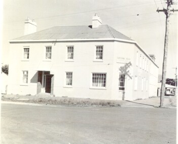
Photograph, March 1960
The Stag Hotel The Stag was built 1848-1854. John Sanders purchased the land from Atkinson in 1848 and built the building as a licensed premises. Over the years it was also used as a Hotel, boarding house and boarding school. It is still used today as Accommodation and a restaurant. This photo is printed in reverse..Black & white photograph of the Sackville street frontage of the Stag Hotel or Seacombe House as now KnownSeacombe House (Back to Front) Port Fairy March 1960hotel, stag, seacombe, sackville street, stag hotel, john sandeers, boarding school, boarding house, coffee palace -
 Port Fairy Historical Society Museum and Archives
Photograph
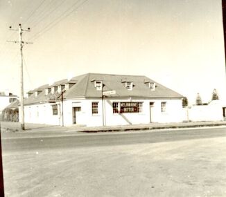
In 1844 a carpenter called David McLaws secured the lease on the land on the south west corner of James and Bank Streets. He later converted this to freehold by which time he had erected the Caledonian Inn. This building has been continually licensed since that time , and is believed to be the longest continual license held in Victoria. The dormer windows in the part of the building facing James street hide the fact that there is only a skeleton of rooms that were meant to be built there. They were unfinished because the labourers left town when gold was discovered at Ballarat in 1853. An advertisement for the time says “There were four parlours, a bagatelle room, eight bedrooms, a detached kitchen, stable and kitchen garden”. Well known hotel Thought to be the oldest continuously licenced hotel in VictoriaBlack and white photograph of 2 story building with dormer windows on corner hotel, building, james street, bank street, david mclaws -
 Port Fairy Historical Society Museum and Archives
Photograph
In 1844 a carpenter called David McLaws secured the lease on the land on the south west corner of James and Bank Streets. He later converted this to freehold by which time he had erected the Caledonian Inn. This building has been continually licensed since that time , and is believed to be the longest continual license held in Victoria. The dormer windows in the part of the building facing James street hide the fact that there is only a skeleton of rooms that were meant to be built there. They were unfinished because the labourers left town when gold was discovered at Ballarat in 1853. An advertisement for the time says “There were four parlours, a bagatelle room, eight bedrooms, a detached kitchen, stable and kitchen garden”. Well known Hotel thought to be the longest continuous licenced hotel in VictoriaBlack and white photographhotel, bank street, port fairy, james street, building -
 Port Fairy Historical Society Museum and Archives
Photograph
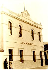
Tennysons Hotel Sackville Street Port Fairy Patrick Tennyson leased the Farmers Inn in 1882 and applied to change the name to Tennysons Hotel. In 1885 he bought the freehold in the Great Land Sale for 780.12.8 (Pounds, shillings and pence) and then carried out extensive renovations. This double storied addition was added in 1893. The hotel continued under various licensees until it burned down in 1977 under the name "Fishermen's Arms". This photograph was taken during the licencee W J WrightBlack and white photograph of facade of two story building hotel, sackville street, port fairy, tennysons, fishermens arms, farmers inn, w.j.wright -
 Port Fairy Historical Society Museum and Archives
Photograph
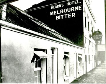
Tennysons Hotel Sackville Street Port Fairy Patrick Tennyson leased the Farmers Inn in 1882 and applied to change the name to Tennysons Hotel. In 1885 he bought the freehold in the Great Land Sale for 780 pounds.12 shillings and 8 pence and then carried out extensive renovations. The double storied addition was added in 1893. The hotel continued under various licensees until it burned down in 1977 under the name "Fishermen's Arms". This photograph was taken during the licencee W J Wright; the single story was the Farmers InnBlack and white photograph of facade of Hearn’s hotel with two advertising signs for beerhotel, sackville street, tennysons hotel, farmers inn, fishermen’s arms, inn, w.j.wright, patrick tennyson -
 Port Fairy Historical Society Museum and Archives
Postcard - Photograph, Seacombe House Port Fairy
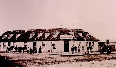
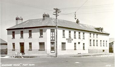
Seacombe House Formerly named The Stag Cnr Sackville and Cox Streets Port Fairy John Sanders (Saunders) first came to Port Fairy in charge of the "Sally Ann" owned by the Henty family of Portland. He left the sea behind in 1844 and established the "Sally Ann Inn" named for his old ship, on the site of the present day Star of the West hotel. After selling the Sally Ann Inn to John Taylor he acquired the land on the South west corner of Sackville Street and erected a detached cottage facing Sackville Street for which he obtained a licence to sell alcohol and named the premises The Stag Inn. He died in 1850 and his wife leased the Inn to John Mason. By 1852 a large two story rendered bluestone building had been constructed on the corner site. The second un rendered section was probably added in 1854. Abijah John Brown became licencee in 1855 and made the Stag the centre of entertainment for the district, with many balls, dinners and concerts taking place there. It boasted "a billiard room and a twenty stall stables and coach house". By 1861 Abijah Brown had left The Stag and Lennox Trew was now owner and licencee. It came up for sale in 1869 but failed to sell. After Trew's death in 1886 it was sold to a syndicate and opened as a boarding school. It later became a Coffee Palace and Accomodation house named Seacombe House, and in the 1950's a motel was built on the old stable site. It is still a Hotel Motel and a restaurant which has revived the old name of "The Stag". Black and white Photograph of 2 story rendered building with multi paned windows and power pole on cornerhotel, lennox trew, abijah brown, john sanders, john saunders, john mason., sackville street, cox street, stag inn, stag hotel, seacombe house, coffee palace -
 Port Fairy Historical Society Museum and Archives
Photograph, Cr J Ritchie Shire of Belfast President1866-67 1869-70
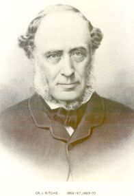
Cr J Ritchie came from Scotland at Hobart in 1833 having been 9 months on the outward journey. he took up land at South Esk and remained there for 6 years.later on advice of the Henry brothers he came to Victoria and after a preliminary inspection of the land charted the brig “William” and with all of his possessions, including 2000 sheep and two servants he arrived in Portland Bay in January 1840 and as he already held a squatting licence No 230 became a settler in the district. he moved along the coast toward Goose Lagoon but due to a drought the water had dried up and forced him to move further eastward to the Upeer Hopkins but the lack of any but brackish water he was forced to return to Aringa. Aringa comprised of 26,000 acres between the Shaw and Moyne Rivers, 640 acres became freehold at one pound and acre with the right to take up leasehold at a low rate according to the number of stock. At Aringa he designed and built his first home part of which still stands today. He married Sarah Elizabeth Davis in 1852 at Weerongurt Station (Mr John Cox’s property). Mrs Ritchie died in 1920. he was elected Shire of Belfast President for the periods of 1866-67 and 1869-70 John had originally chosen to practice law as his vocation in Scotland but abandoned law for the open air life and died at the age of 86 years in 1887 elected Shire of Belfast President for the periods of 1866-67 and 1869-70Black and white portrait photograph Cr J Ritchie 1866-67 1869-70belfast, president, council, portrait, government, shire, municipal, local-government -
 Port Fairy Historical Society Museum and Archives
Photograph, Cr William Boyd Shire of Belfast President 1891-92 95-96
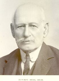
Councillor William Boyd was the son of Alexander Boyd who emigrated from Scotland and purchased the property known as Tarrone station in 1884. William managed the station grazing cattle and sheep. The area was later to become part of the Soldier Settlement land after the Second World War.Black and white portraitbelfast, president, government, portrait, shire, council, municipal, local-government, tarrone -
 Port Fairy Historical Society Museum and Archives
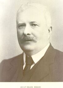
Photograph, Cr AF Molan Shire of Belfast President 1892-93
Councillor AF Molan owned land in Crossley close to where the Shamrock Hotel was built. The Council held it’s meetings at this hotel for some time.Black and white portraitgovernment, belfast, president, portrait, shire, municipal, local-government, cr af molan -
 Port Fairy Historical Society Museum and Archives
Photograph
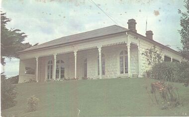
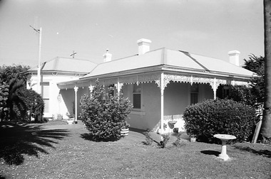
The construction of Seaview commenced in 1860, after David Talbot, purchased the land from James Atkinson,It had been suggested that it was intended to be double storied but there is no evidence of how that would have been accomplished. Following Talbot’s insolvency, Michael O’Reilly leased the house in 1862 until 1876 when he left for Melbourne.William Powling (Solicitor) acquired the house for Eight hundred and twenty three pounds in 1890 and lived there the rest of his life. His son Ernest Powling continued living there before selling it to Matthew Cathcart in 1917.Coloured photograph of White painted stone house with bay window to right and large verandahcottage, building, home, house, seaview -
 Port Fairy Historical Society Museum and Archives
Photograph
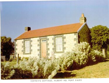
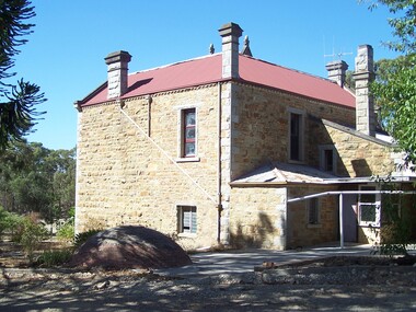
65 Albert Road. the land was first owned by George Bull when he bought it in 1860. The house was built around 1862. Members of the family owned it until 1893 when it was sold to William Johnson. Johnson died in 1897 and Catherine Sara Ryan nee Hain bought it and lived there until she died in 1927. The cottage was then sold to the Coffey family who retained the property until 1974. The cottage is conventional coursed limestone building with bluestone quoins, gabled roof, chimneys at each end and a skillion on the western side, added at a later date. It was originally a two-roomed dwelling with kitchen. Behind the cottage is a slab-sided wooden gable ended shed, containing a large limestone rubble chimney and a sleeping area within the south facing skillion section. It is unlikely that it is older than the cottage, but it is an unusual, crude structure, presumably for general farming purposes.Coloured photographcottage, building, home, house, coffey's cottage, albert road, ryan, hain, johnson, george bull -
 Port Fairy Historical Society Museum and Archives
Photograph
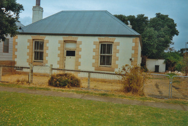
The land was bought in 1853 by John Smith and he built the house. The house was offered for sale in 1866 when George Barnacle bought it and named it 'Warwick Cottage' after his birth place. it was offered to short term tenants such as the surveyor Creed, Miss Boes a dressmaker and O'Doherty the Catholic school teacher. In 1874 Dr Rastrick was a tenant and in 1878 it was occupied by the grocer William Searle and his sister a dressmaker. Barnacle offered the cottage for sale in October 1885 advising that the iron roofed stone cottage , 4rooms, detached kitchen and outhouses had been previously occupied by W.C.Uncles and at that time William Muhleg Carpenter. It ultimately sold privately to Miss Beatty and she continued to rent it to tenants. James Kilbride was the tenant in 1887-88. The cottage was sold in 1888 to Isaac Smale. The house continued its tradition of housing dressmakers with Mrs Barby carrying on that profession in the 1940's,50's and 60's. Coloured photographcottage, building, home, house, 77 cox street, warwick cottage -
 Port Fairy Historical Society Museum and Archives
Photograph
martin's Point from the air very early (research ongoing)black and white aerial photograph of Martin's Point Port Fairyaerial, martins point, dredge, boat, river, land -
 Port Fairy Historical Society Museum and Archives
Negative - Photograph
The construction of Seaview commenced in 1860, after David Talbot, purchased the land from James Atkinson,It had been suggested that it was intended to be double storied but there is no evidence of how that would have been accomplished. Following Talbot’s insolvency, Michael O’Reilly leased the house in 1862 until 1876 when he left for Melbourne.William Powling (Solicitor) acquired the house for Eight hundred and twenty three pounds in 1890 and lived there the rest of his life. His son Ernest Powling continued living there before selling it to Matthew Cathcart in 1917.negative, seaview, house -
Friends of St Brigids Association
Book - A green and pleasant land, or the story of Koroit, 1836-1970, McCorkell, Harry Allan. 1970. A green and pleasant land, or the story of Koroit, 1836-1970. Koroit [Vic.] : "The Koroit Sentinel" for the Mayor, Councillors and People of Koroit, 1970 150 p. : ill., ports. ; 23 cm
-
 Glenelg Shire Council Cultural Collection
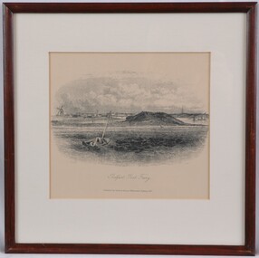
Print, S.T. Gill, Belfast Port Fairy, 1857
Port of Portland Collection.Depiction of a boat with furled sails on choppy waters, sailing towards land. The landscape includes a hill and several buildings, including a wind mill and a church spire. Mounted in cream matt. Framed under glass in wooden frame.Front: Belfast Port Fairy (lower centre) (printed). Published by Sands & Kenny, Melbourne & Sydney 1857. Back: 19 Upper left pencil. 1996 upper right pencil.port fairy, belfast, landscape, drawing, print, coastal, 1800s -
 Warrnambool and District Historical Society Inc.
Book, Thalaba the destroyer Vol 1, 1821
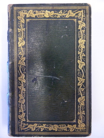
This book was written in 1801 in an epic poem form. It is unrhymed. It falls into the category of fantasy. The original owner of this book seems to have been John Bland. He is most important in the early history of Port Fairy and had a business in Port Fairy with John Cowtan (corn millers and general merchants). The Cowtans originally had land in the vicinity of the Cassady property of Boughton, Merri River (in Caramut Road near Cassady’s Bridge today) and were related by marriage to the Cassadys. A later owner of the book was William Anderson whose father came to the Yangery district in 1854 and established the property of Rosemount and William remained in this area until his death in 1909. The Andersons were related by marriage to the Cassadys and this book came to us following a clearance sale at the Cassady property, Boughton. This book is of great interest less for its literary content than for its ownership which probably dates back to the 1840s. It is associated with the families of Bland, Cowtan, Cassady and Anderson, all early settlers in Warrnambool and district.This is a brown leather-covered book of 271 pages. The cover has gold decorative borders and patterns and gold lettering. The pages are gilt-edged. The book is the fourth edition of volume one of a Robert Southey poem and has a Preface and Books 1 to 5 with Notes. The inscriptions are handwritten in black ink. One signature has not been deciphered. ‘Wm. Anderson’ ‘John Bland’ william anderson,, rosemount, william cassady, john bland, john cowtan, thalaba the destroyer, warrnambool, poem thalaba the destroyer, 19th century poems, robert southey books -
 Bendigo Historical Society Inc.
Document - Rocky Vale Beebe House, 2010 to 2015
The Beebe name was well-known in Bendigo in the last quarter of the 19th and the early part of the 20th centuries. From 1875, William Beebe senior, monumental mason, occupied a site in the centre on the city, in Mitchell Street opposite King Street. Death was more part of life in those days, and the Beebes were there to provide the burial monuments. Later, he took his sons into the business, which grew as Beebe and Son. Many examples of their work can be found in the local cemeteries. William Beebe senior (1830-1891) was born in Rutland, the smallest English county in 1830, to stonemason Chamberlain Beebe and Susannah Clements. William emigrated to Victoria in 1854 and after engaging on unknown works in Port Fairy, Dunkeld, and Melbourne arrived in Bendigo. His obituary records that he commenced work here on the site of the Bank of Australasia (opposite the Shamrock Hotel), which would have been no later than 1856. He took up a 13 acre selection on the site of Rocky Vale Villa in 1864 and continued to select or purchase further parcels of adjoining land until he owned some 150 acres, much of it unfit for cultivation. He was a keen gardener and had a garden and orchard around the house. William took over 20 years to build the two-story sandstone and granite house "Rocky Vale Villa". The house was constructed from sandstone sourced "from an adjacent ridge of rocks" (Bendigo Advertiser 28/9/1891). Granite from Harcourt was used for lintels and quoins. Not long before he died, William was still adding to the house. In the Codicil to his will, he states that "I have just built and completed two additional rooms to my Dwelling house situe at Inglewood Road aforesaid" (dated 19/9/1891). William died one week later on the 26th September 1891.Photographs and Historical Documents relating to Rocky Vale Villa, 7 Wicks Road, Maiden Gully, Bendigo by the Bendigo Historical Society.history, bendigo, rocky vale villa maiden gully, william beebe stonemason bendigo -
 Warrnambool and District Historical Society Inc.
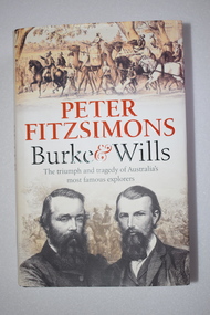
Book, McPherson’s Printing Group, Burke & Wills, 2017
This book gives a comprehensive and scholarly account of the ill-fated Burke and Wills expedition in Australia in 1860-1961. It is written by Peter Fitzsimons. The narrative includes the parts played in the expedition by two men who also had important connections to Warrnambool. One of these was Henry Foster who was Superintendent of Police in Swan Hill in the 1860s. In the early 1840s Henry Foster and Thomas Strong took up a run of 16.000 acres (St. Mary’s, Wangoom)). Their land was bounded on the south by the Southern Ocean, on the east by the Hopkins River, on the north by a fence from the Hopkins to the Merri Rivers and on the west by the Merri River and included the later surveyed site of the Warrnambool township. After Warrnambool was established Foster was able to retain 450 acres of the original run near Wangoom on the Hopkins River. He was active in Warrnambool’s early history, was a Justice of the Peace for the Belfast (Port Fairy) district in the late 1840s and his portrait is on the Warrnambool Pioneer Honour Board. The other local Warrnambool personality mentioned in the Burke and Wills book is Richard Bennett, in the 1860s, the manager of several large farming properties in N.S.W., including Canally Station on the Murrumbidgee where he came into contact with the expedition leaders. In the Warrnabool district Bennett was well-known from the 1870s to his death in 1904 as the proprietor of wool-scouring establishments on the Shaw River and at Dennington and as a public campaigner for local coal exploration, for artesian bore drilling and for numerous other projects, including the development of the local wool industry. His portrait is also on the Warrnambool Pioneer Honour Board. This book is retained as an account of an important event in Australia’s history and because it has several references to two men (Henry Foster and Richard Bennett) who also played a part in Warrnambool’s history. This is a hard cover book of 700 pages. The cover is black with gold printing on the spine and the dust cover has a cream background with light brown and black printing, black and white photographs and sepia-coloured sketches. The contents include a List of Maps, Dramatis Personae, Background and Acknowledgements, Prologue, 18 Chapters, Epilogue, Endnotes, Bibliography and Index. The pages contain maps, sketches and black and white and colour photographs. australian exploration, burke and wills expedition, richard bennett, warrnambool, henry foster, st. mary’s wangoom, history of warrnambool -
 Warrnambool and District Historical Society Inc.
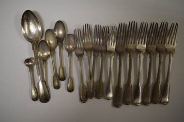
Functional object - Cutlery, George Rolfe, Mid to late 19th century
In 1854 in Melbourne George Rolfe Senior established an import business dealing in groceries, wines and spirits and tea. His son George, born in England, took over the business of Rolfe and Co in 1871. A keen sportsman, George Rolfe’s love of fishing led him to take frequent holidays in Warrnambool. He began buying blocks of land near the mouth of the Hopkins River in Warrnambool in the 1870s. By the 1880s Rolfe owned 50 acres in the Hopkins River area and named the property, Lyndoch. He built stables, chaff and bone sheds, a jetty, a boatshed, a water well, a windmill, a reservoir and extensive gardens. He also bought the nearby properties of Shipley and Fairy Hill, establishing a stud farm and breeding cattle. In 1891 he married Jane Ann Lake, the widow of his property manager, and when he died in 1919 his step-daughters, Florence and Annie Lake, inherited Lyndoch. The property was sold and became an aged care facility in 1952. The cutlery items were in use in the building erected by Florence Lake in 1920 and known today as Lyndoch but the ‘R’ monogram on the items suggest that they belonged to George Rolfe or even his father before him.These cutlery items are of considerable importance as mementoes of George Rolfe and his family. They were prominent in Warrnambool’s history in the late 19th and early 20th centuries with the establishment and development of the property, Lyndoch, near the mouth of the Hopkins River. These are 17 pieces from a silver cutlery set that belonged to the Rolfe family (one tablespoon, six large forks, five smaller forks, four small spoons and one mustard spoon.) All the pieces of cutlery have a monogrammed ‘R’ at the end of the handles. Twelve of the items are tarnished and one small spoon is very worn. All the items have six hallmarks. ‘R’george rolfe, lyndoch, warrnambool, rolfe & co. melbourne, florence lake, lyndoch warrnambool., history of warrnambool -
 Flagstaff Hill Maritime Museum and Village
Map - Survey Map, F.F. McGovern, Yangery - County of Villiers, 1884
A surveyor was employed to measure the land designated as Yangery, County of Villiers, in the Borough of Warrnambool. The area on the map is similar to the earlier Farnham Survey undertaken by William Rutledge in the 1850's. Warrnambool was a Borough between 1863-1883. Coutours, waterways, sea and other significant points are shown. The distances are accurately measured. This survey map was used for planning future land sales, recreation areas and roads. WILLIAM RUTLEDGE (1806-1876) William Rutledge surveyed the land known as Farnham in southwest Victoria in 1843. His tenants made him a profitable business from working the land there. In 1863 Rutledge moved from nearby Port Fairy to Farnham and became very successful in breeding sheep, which he imported from J.R. Kirkham of Lincolnshire, England. He also bred horses on his land. The survey map of Yangery is important for its connection with renowned surveyor William Rutledge. The map shows the growth of landholders in the district when compared to the original Rutledge survey of the 1850's.Survey map of Yangery, titled "Yangery - County of Villiers". Printed on white paper, mounted on brown paper. c. 1863-1876. Comments printed on the Map include; Special Survey by William Rutledge, Photo-lithographed at the Department of Lands and Survey, Melbourne by W.J. Burson, Price 1/- [one shilling]. Scale is in Chains. Map has boundaries of Koroit Borough, Meerai, Purnim, Wangoom, Borough of Warrnambool, Mentions the Proposal of Tower HIll for Public Recreation. The map names the owners of the land at that time. Hand written pencil marks and figures and "Sauls fence" drawn on map. Hand written pencil markes and figures and "Sauls fence" drawn onto map. "For Department Use only". "Scale: 8 chains to 1 inch" flagstaff hill, warrnambool, shipwrecked-coast, flagstaff-hill, flagstaff-hill-maritime-museum, maritime-museum, shipwreck-coast, flagstaff-hill-maritime-village, county of villiers map, yangery district, w.j. burson, borough of warrnambool, koroit, purnim, meerai, wangoom, proposal of tower hill for public recreation, special survey by william rutledge, william rutledge, farnham, lincolnshire sheep, clydesdale -
 Ringwood and District Historical Society
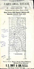
Flyer, Residential Land Sale Sub-division - Fairy Dell Estate, Warranwood, Vic. - circa 1950s
... Residential Land Sale Sub-division - Fairy Dell Estate.... Handwritten 1970s real estate price notations for some blocks. Land ...Land sale advertisement for 50 home sites with map of Sub-division showing layout of streets and allotments, summary of local features and services and terms of sale, and copy of sectional map of Crown Allotments 20 & 21B Parish of Warrandyte also showing layout of Sub-division.Subdivision includes Grandview Grove (later Bemboka Road), Merrill Crescent and Kerry Road, Warranwood. Estate Agents - V.C. Swift & Son R.E.S.I., Main Street, Croydon, Phone 20. Solicitors - Morgan, Fyffe & Mulkearns, 108 Queen Street, Melbourne. Handwritten 1970s real estate price notations for some blocks. -
 Port Fairy Historical Society Museum and Archives
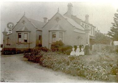
Photograph, Pt Fairy Hospital looking east 1890, 1890
The land for this building was granted to the Benevolent Society by James Atkinson in 1850. Tenders were called for a new "Benevolent Asylum" in 1855, the foundation stone having been laid and by 1856 the first part of the Hospital was completedBlack and white photograph New addition to the hospital with i’ts bay windows. 5 women and two men posed to the sidehospital, health service, nurses, bay window -
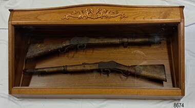 Flagstaff Hill Maritime Museum and Village
Weapon - Historic Rifles, Royal Small Arms Factory, 1877-1900
Martini-Henry Artillery Carbin rifles were made by the Royal Small Arms Factory at Enfield, Britain, from 1877 until 1900. Many were distributed to the British Colonies, including this pair, which was allocated to the Woodford Police, Victoria Police District of Warrnambool, Southwest Victoria. The Carbine model rifles were shorter than the standard rifles and more suited to mounted police and troopers. It is likely that in the early 20th century, Victoria Police replaced the two carbines with more modern firearms, and the outdated guns were stored in the stables. The rifles were left there and likely forgotten about due to changes in police staff. In 1915, police authorities announced that they would be replacing patrol horses with bicycles and would also close some smaller police stations. This affected Woodford Police Station, which closed in 1917. The forgotten firearms remained in the stables and were noticed by schoolboy Robert Jellie in 1940 and seen again in 1946. In 1995, the property was sold by the Education Department to a private owner. The Woodford Community donated the pair of Martini-Henry Carbines to Victoria Police Museum in the late 1990s for mounting and display, which was funded by the Victoria Police Historical Society Inc. The decorative wood and glass display case and frame were designed to preserve the significant history of the guns. On November 1st 1999, the display was presented to Warrnambool Police and the local community due to the historical significance of the Woodford Police Station. On March 10th, 2025, the display was transferred to Flagstaff Hill Maritime Museum and Village, where the historical story of the Martini-Henry Carbines could continue to be preserved and accessed by local families, the community, visitors to the area, and online visitors. WOODFORD POLICE: - The small settlement at Woodford was established in the 1840s around the Merri River where there was a ford across the water and, from 1848-1851, a bridge. The area was settled very early in Victoria’s history and the river crossing provided travellers with access to the early route between Port Fairy (name Belfast at that time), Warrnambool and Melbourne. Occasionally a Warrnambool police trooper would ride through Woodford and district. In December 1854, Woodford Police barracks and stables were built on the hill by the Merri River on Bridge Road east where Jubilee Park now stands. A local mounted trooper kept law and order in the area. In 1856, a lock-up was installed, and the first Woodford Police Station was in action in 1857. By 1871, the police station had been moved from the hill to land across the Merri River bridge, on the southern side of Bridge Road west, near Mill Street. In 1890, the police residence there was replaced by a stone Edwardian-style building with the stables and lock-up behind it and the old police station at the rear. The police continued to have a presence in Woodford until it was closed by the Police Commissioner in July 1917 for economic reasons. The residence was used for government housing until 1923, when it was taken over by the Education Department for the school teacher’s home. In 1995, it became privately owned. THE MARTINI-HENRY ARTILLERY CARBINE: - The Martini-Henry rifles were made in Britain from 1871 at the Royal Small Arms factory at Enfield and were stamped with the symbol of the Royal Cipher (Crown over VR) over ENFIELD to identify their origin. They were named after two of several people who helped design this method: Swiss Friederich von Martini and Scotsman Alexander Henry. The design was breach-loaded, and the inner barrel was rifled. A thumb rest was incorporated into the top right of the bullet receiver’s chamber. The small teardrop lever on the right side of the rifle showed whether the rifle was ready to be shot. In 1877, the shorter, lighter weight Carbine version of the firearm was produced for mounted troops and artillery. Its official name was “Carbine, B.L., Rifled, Martini Hanry.” The bullets were slightly lighter in weight than those used for the longer rifle. The sight position was adjusted for the shorter gun, and wings were added to the sight on the tip, making it easier to slide the rifle back into a saddle bag. Some of the later Carbines also had leather sight covers screwed to the stock to prevent them from catching on the saddle bags. The Carbines had accessories available, such as barrel extensions with bayonets and swivels for adding slings. The Martini-Henry Carbine designs were later modified to fire the British .303 ammunition. Eventually, by 1900, the Martini-Henry Carbines were replaced by the Lee Enfield gun design. The pair of Martini-Henry Carbine firearms represents policing in the early pre-1900 days of colonial settlement; Woodford was one of the first townships settled in Victoria, and it had a police presence from 1854 until 1917. The rifles and display provide a historic connection between the location of Woodford and relatives and associates. The carbine rifles show a stage in the evolution of weapon design, adapted to suit mounted troops, and adding features to streamline use and storage. The ammunition was also improved during this progression. The carbines are important for their connection to policing law and order in a remote area. They are significant for their association with the township of Woodford, which was important to travel in the southwest Victoria district, providing access across a river for a road between Port Fairy and Melbourne, and later Warrnambool, and supplying food, goods and accommodation for the travellers. A pair of mounted rifles is mounted behind glass in a timer case, accompanied by a framed display of two photographs and an account of the rifles’ history. The case and display each have a horizontal board with a gently curved edge and carved decorations added. The identical firearms are British-made Martini Henry Carbine breach-loaded rifled guns, supplied by Britain to its Colonial troops from around 1877. The rifles are lever-action, single-shot .500 calibre weapons. They have a teardrop lever on their right side. They were used by Victoria Police mounted troops at the Woodford Police Station, Victoria. The black and white photographs were taken in 1946. The left photograph has a circled area; the right photograph is an enlarged view of the circled area, showing the Woodford Police Station in detail. The printed text is on textured paper with the Victoria Police watermark. It gives a summary of the rifle’s history. There is an inscription on the left photograph. Left photograph, handwritten in white pen: “WOODFORD” Document’s print: “During the late 1840s the small town of Woodford grew around the crossing of the Merri River on the Melbourne/Port Fairy Rad. Woodford was proclaimed a township in 1854 and a police quarters was established there in 1857. The police station remained until 1917 when it was closed and police service from then on was provided from Warrnambool. The building was then used as a school residence and is now privately owned. In !940 Robert JELLIE, then a schoolboy, observed two rifles mounted on the wall of the disused stable at the rear of the old police building. Following the devastating flood of 1946 (see photograph above) the rifles were again seen in the room next to the stable but were not seen again until the building was sold by the Education Department many years later. It was a recognition of the historical value of the rifles which led to their donation to the Warrnambool Police Complex. The rifles have been authenticated by the Victoria Police Armoury as being Victoria Police issue some time before 1900. The rifles are an identical pair of the famous British-made Martini Henry, a .500 inch calibre military weapon widely used by British Colonial troops. Victoria Police and the wider community of Warrnambool are indebted to the members of the Woodford community for their fine gesture in donating the rifles for mounting so that their historical importance can be preserved and they can be displayed for generations to come. This display was funded by the Victoria Police Historical Society Incorporated, and presented on the first day of November, 1999.”flagstaff hill maritime museum and village, great ocean road, shipwreck coast, martini henry, victoria police, woodford police station, rifle, carbine, display case, british, martini henry carbine, breech-loaded, rifled, colonial, single-shot, .500 calibre, weapon, gun, 1877, troops, mounted troops, merri river, victoria police woodford, victoria police warrnambool, victoria police melbourne, police quarters, robert jellie, school residence, stable, 1946 flood, victoria police armoury, identical pair, british colonial troops, victoria police historical society incorporated, woodford, bicycles, found by a schoolboy, edwardian-style building -
 Flagstaff Hill Maritime Museum and Village
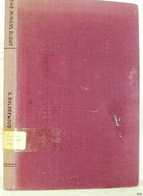
Book, The Miners Right
This item is from the ‘Pattison Collection’, a collection of books and records that was originally owned by the Warrnambool Mechanics’ Institute, which was founded in Warrnambool in 1853. By 1886 the Warrnambool Mechanics’ Institute (WMI) had grown to have a Library, Museum and Fine Arts Gallery, with a collection of “… choice productions of art, and valuable specimens in almost every branch and many wonderful national curiosities are now to be seen there, including historic relics of the town and district.” It later included a School of Design. Although it was very well patronised, the lack of financial support led the WMI in 1911 to ask the City Council to take it over. In 1935 Ralph Pattison was appointed as City Librarian to establish and organise the Warrnambool Library as it was then called. When the WMI building was pulled down in 1963 a new civic building was erected on the site and the new Warrnambool Library, on behalf of the City Council, took over all the holdings of the WMI. At this time some of the items were separated and identified as the ‘Pattison Collection’, named after Ralph Pattison. Eventually the components of the WMI were distributed from the Warrnambool Library to various places, including the Art Gallery, Historical Society and Flagstaff Hill. Later some were even distributed to other regional branches of Corangamite Regional Library and passed to and fro. It is difficult now to trace just where all of the items have ended up. The books at Flagstaff Hill Maritime Village generally display stamps and markings from Pattison as well as a variety of other institutions including the Mechanics’ Institute itself. RALPH ERIC PATTISON Ralph Eric Pattison was born in Rockhampton, Queensland, in 1891. He married Maude Swan from Warrnambool in 1920 and they set up home in Warrnambool. In 1935 Pattison accepted a position as City Librarian for the Warrnambool City Council. His huge challenge was to make a functional library within two rooms of the Mechanics’ Institute. He tirelessly cleaned, cleared and sorted a disarrayed collection of old books, jars of preserved specimens and other items reserved for exhibition in the city’s museum. He developed and updated the library with a wide variety of books for all tastes, including reference books for students; a difficult task to fulfil during the years following the Depression. He converted all of the lower area of the building into a library, reference room and reading room for members and the public. The books were sorted and stored using a cataloguing and card index system that he had developed himself. He also prepared the upper floor of the building and established the Art Gallery and later the Museum, a place to exhibit the many old relics that had been stored for years for this purpose. One of the treasures he found was a beautiful ancient clock, which he repaired, restored and enjoyed using in his office during the years of his service there. Ralph Pattison was described as “a meticulous gentleman whose punctuality, floorless courtesy and distinctive neat dress were hallmarks of his character, and ‘his’ clock controlled his daily routine, and his opening and closing of the library’s large heavy doors to the minute.” Pattison took leave during 1942 to 1945 to serve in the Royal Australian Navy, Volunteer Reserve as Lieutenant. A few years later he converted one of the Museum’s rooms into a Children’s Library, stocking it with suitable books for the younger generation. This was an instant success. In the 1950’s he had the honour of being appointed to the Victorian Library Board and received more inspiration from the monthly conferences in Melbourne. He was sadly retired in 1959 after over 23 years of service, due to the fact that he had gone over the working age of council officers. However he continued to take a very keen interest in the continual development of the Library until his death in 1969. WARRNAMBOOL PUBLIC LIBRARY The Warrnambool Mechanics’ Institute (WMI) was formed by a voluntary community group in 1863, within six years of Warrnambool’s beginnings, and its Reading Room opened in 1854. The WMI operated until 1963, at which time it was one of the oldest Mechanics’ Institutes in Victoria. Mechanics’ Institutes offered important services to the public including libraries, reading rooms and places to display and store collections of all sorts such as curiosities and local historical relics. In 1886 a Museum and Fine Arts Gallery were added to the WMI and by the beginning of the 20th century there was also a billiards room and a School of Art. By this time all Mechanics’ Institutes in country Victoria had museums attached. Over the years the Warrnambool Mechanics’ Institute Library was also known as the Warrnambool Public Library the Warrnambool Library and the Free Library. Early funding from the government was for the “Free Library”. The inscription in a book “Science of Man” was for the “Warrnambool Public Library”, donated by Joseph Archibald in 1899. Another inscription in the book “Catalogue of Plants Under Cultivation in the Melbourne Botanic Gardens 1 & 2, 1883” was presented to the “Warrnambool Library” and signed by the author W.R. Guilfoyle. In 1903 the Warrnambool Public Library decided to add a Juvenile Department to library and stock it with hundreds of books suitable for youth. In 1905 the Public Library committee decided to update the collection of books and added 100 new novels plus arrangements for the latest novels to be included as soon as they were available in Victoria. In July 1911 the Warrnambool Council took over the management of the Public Library, Art Gallery, Museum and Mechanics’ Institute and planned to double the size of the then-current building. In 1953, when Mr. R. Pattison was Public Librarian, the Warrnambool Public Library’s senior section 10,000 of the 13,000 books were fiction. The children’s section offered an additional 3,400 books. The library had the equivalent of one book per head of population and served around 33 percent of the reading population. The collection of books was made up of around 60 percent reference and 40 percent fiction. The library was lending 400 books per day. In 1963 the Warrnambool City Council allocated the site of the Mechanics’ Institute building, which included the Public Library, Museum and Art Gallery, for the new Municipal Offices and the Collections were dispersed until 1971. The Warrnambool Library took over the Mechanics’ Institute Library’s holdings on behalf of the Warrnambool City Council. Since the closure of the Warrnambool Mechanics’ Institute the exact location and composition of the original WMI books and items has become unclear. Other materials have been added to the collection, including items from Terang MI, Warrnambool Court House and Customs House. Many of the books have been identified as the Pattison Collection, named after the Librarian who catalogued and numbered the books during his time as Warrnambool Public Librarian in the time before the Mechanics’ Institute closed. It seems that when Warrnambool became part of the Corangamite Regional Library some of the books and materials went to its head office in Colac and then back to Warrnambool where they were stored at the Art Gallery for quite some time. Some then went to the Warrnambool Historical Society, some stayed at the Art Gallery and some were moved to Flagstaff Hill Maritime Village. The various stamps and labels on the books held at Flagstaff Hill show the variety of the collection’s distribution and origin. The books in the collection at Flagstaff Hill Maritime Village date from the 1850’s to the late 1950’s and include rare and valuable volumes. Many of the books are part of the “Pattison Collection” after the Warrnambool’s Public Librarian, Mr. R. Pattison. Rolf Boldrewood (1826-1915) ‘Rolf Boldrewood’ is the pen-name used by Thomas Alexander Browne as a writer. Browne was the eldest child of Captain Sylvester John Brown and Elizabeth Angell nee Alexander. He was born in London on 6th August 1826 and arrived in Australia with his parents and siblings when he was 5 years old and grew up in Sydney. In the 1860’s Browne added the ‘e’ to his surname. As a 17 year old Browne took up land in the Western District of Victoria between Portland and Port Fairy on a property named “Squattlesea Mere”. He remained there until 1858, enjoying the squatters’ life on his 32,000 acre property, growing potatoes and running cattle and horses. He sold in 1858 and purchased a sheep station on the Murray River near Swan Hill. He later sold this and bought another sheep station near Narrandera until bad seasons and severe droughts eventually caused him to change his career after 25 years as a squatter. Over the next 25 years Browne held the position of Police Magistrate and as a gold commissioner in various locations. His third career as an author lasted approximately 40 years. In 1865 he wrote two articles on pastoral life while he was recovering from a riding accident. In the 1870’s his writing was bringing in the income to support his family, changing his focus to the writing of novels. A series of these was written for the Australian market and published in The Sydney Mail and the Centennial Magazine. His later novels were aimed at the overseas markets. His best known novel “Robbery Under Arms” was written from 1882 to 1883 and has been serialised on radio in Australia and Britain. The novel was filmed in 1907, 1920 and 1957, and in 1985 it was made into a television series. It is now an Australian Classic. He also wrote short stories, several nonfiction graziers’ guides, and an autobiography named “Old Melbourne Memories” in 1884. [This information has been taken from Wikipedia; Australian Authors-Perry Meddlemiss; Australian Dictionary of Biography, Browne, Thomas Alexander (1826-1915)] The Pattison Collection, along with other items at Flagstaff Hill Maritime Village, was originally part of the Warrnambool Mechanics' Institute’s collection. The Warrnambool Mechanics’ Institute Collection is primarily significant in its totality, rather than for the individual objects it contains. Its contents are highly representative of the development of Mechanics' Institute libraries across Australia, particularly Victoria. A diversity of publications and themes has been amassed, and these provide clues to our understanding of the nature of and changes in the reading habits of Victorians from the 1850s to the middle of the 20th century. The collection also highlights the Warrnambool community’s commitment to the Mechanics’ Institute, reading, literacy and learning in the regions, and proves that access to knowledge was not impeded by distance. These items help to provide a more complete picture of our community’s ideals and aspirations. The Warrnambool Mechanics Institute book collection has historical and social significance for its strong association with the Mechanics Institute movement and the important role it played in the intellectual, cultural and social development of people throughout the latter part of the nineteenth century and the early twentieth century. The collection of books is a rare example of an early lending library and its significance is enhanced by the survival of an original collection of many volumes. The Warrnambool Mechanics' Institute’s publication collection is of both local and state significance. The Miners Right A tale of the Australian Goldfields Author: Rolf Boldrewood Publisher: Macmillan And Co Date: 1922Label on spine cover with typed text R.A. 823.91 BOL Pastedown front endpaper has sticker from Warrnambool Public Library warrnambool, shipwrecked-coast, flagstaff-hill, flagstaff-hill-maritime-museum, maritime-museum, shipwreck-coast, flagstaff-hill-maritime-village, shipwrecked-artefact, book, pattison collection, warrnambool library, warrnambool mechanics’ institute, ralph eric pattison, corangamite regional library service, warrnambool city librarian, mechanics’ institute library, victorian library board, warrnambool books and records, warrnambool children’s library, great ocean road, the miners right, australian goldfields, australian rush, rolf boldrewood, gold rush