Showing 12057 items
matching geo-map
-
 Orbost & District Historical Society
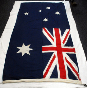
flag, 1960/1970's
This flag was used by St Joseph's School, Orbost at assemblies. St Joseph's Catholic School in Orbost was planned from 1913 when the town's population was increasing rapidly. It wasn't until 1923 that the school was built in Raymond Street next to St Colman's Church. Fifty-five students were initially enrolled and taught in two rooms. When the numbers increased to 170 work began on extensions which were completed in 1959. St Joseph's school had classes to Form 4 at one stage. Later on Form 2 was the highest level. However, after Nagle College at Bairnsdale built a new school on the Lindenow Road site, a Nagle College school bus ran from Orbost and the school was reduced to Grade 6. It was also about this time that the last of the St Joseph teaching nuns left Orbost. From 1969 to the early 1980s the secondary St Joseph students attended Orbost High School for the practical subjects of Woodwork and Home Economics. Today enrolments reflect the declining population of the district. This item is an example of an item used in an Orbost school in the second half of 20th century.A cloth Australian National Flag which has a blue background. The Union Jack is in the upper left corner. Below the Union Jack is a white Commonwealth Star. The Southern Cross is shown on the right hand side of the flag in white. There is a white rope and two metal clips inserted into the left hand pocket/seam.Inside a diamond is N.V. BRAND. Geo. PICKERS Co. P/L CANVASflag-australian st-joseph's-school-orbost heraldry -
 Old School House Museum
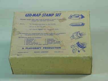
Rubber Stamp Set
... geo-map ...Used by teachers for teaching geography, they would take the plate and attach to the handle, stamp it into ink and would make multiple copies for the students to either identify capital and countries or to learn the shape and localities of each locationIt was an early way of making multiple copies for teaching students.Geography stamp set in box which include 4 plates and handle. Plates include, Asia,Africa,Victoria,The world Geo-Map Stamp Setfrankston primary school, rubber stamps, education, geo-map, victoria, asia, the world, africa, playcraft production -
 Federation University Historical Collection
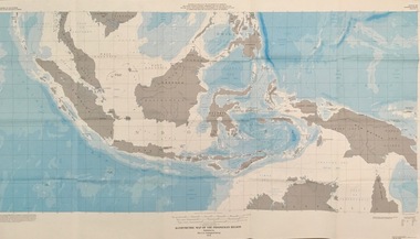
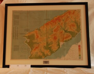
Map - Geological, U.S. Government Printing Office, Bathymetric Map of the Indonesian Region: Folio of the Indonesian Region Map I-875-A, 1974, 1974
Map was prepared on behalf of the Government of Indonesia, The United Nations Economic Commission for Asia and the Far East, the Agency for International Development and the U.S. Department of State in cooperation with the Geological Survey of Indonesia. The area covered shows the islands and seas from Latitude 12 degree North to 16 degrees South and Longitude 90 degrees to 148 degrees. Various water features are also named.Large map showing the Indonesian area - islands and seasLongitude and Latitude are shown. Major / Capitol cities indicated. Names of those responsible for the productionindonesia, united nations economic commission, department of state, geological survey, latitude, longitude, government of indonesia -
 Bacchus Marsh & District Historical Society
Map, Coimadai Parish Map, County of Bourke. Circa 1890s-1900s
The cadastral Parish of Coimadai, a subdivision of the County of Bourke, lies directly north of the township of Bacchus Marsh. The date of this map is uncertain. T.F. McGauran the person who made a photo-lithographic copy of the map was in charge of photo-lithography at the Victorian Department of Lands and Survey in the late 19th century until about 1910.A single page paper map showing the map for the Parish of Coimadai in the County of Bourke. A cadastral map showing parish boundaries and land ownership. A rectangle shaped area is missing from the centre of the map due to a tear or deliberate excision. The map is pasted into a bound volume containing 76 maps or plans in total. High resolution digital image stored on BMDHS computer network. Photo-lithographed at the Department of Lands and Survey, Melbourne by T.F. McGauran 26.8.[??] NOTE. Photo litho from L.P showing temporary surveys and occupation of land prepared for departmental use onlybacchus marsh region parish plans, coimadai parish maps, coimadai parish plan -
 Federation University Historical Collection
Plan (copy), Frederick Proeschel, Map of the Roads to all the Gold Mines in Victoria, 1853
The map was pirated from Frederick Proeschel's "Pocket Map of the Roads to all the Gold Mines in Victoria" issued earlier in 1853.Digital file of the Map of the Roads to all the Gold Mines in Victoria. The map has been coloured to show routes to the Victorian goldfields from Melbourne and Geelong.frederick proeschel, proeschel, gold, mining, philp -
 Melbourne Tram Museum
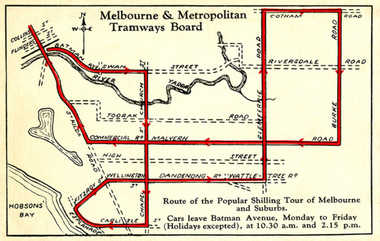
Drawing - Digital Image, Shilling Tour Map, 1927
Map shows the route of the Shilling Tour Map, using Y469 - shows the direction of travel and departure times from Batman Ave. Destination City 5th Edition notes that the services with the tram commenced in June 1927.Yields information about the MMTB's 1927 Shilling tour of Melbourne.Digital Image of an MMTB Map.trams, tramways, y class, tours, tourist trams, tourist trips, tram 191 -
 Bacchus Marsh & District Historical Society
Map, The Unique Advertising Combine, The Unique Combine's New Map of the Shire of Bacchus Marsh, 1890
This map was one of a number of similar maps produced for advertising purposes by a company called, 'The Unique Advertising Combine'. The company was located in Melbourne on Queens Walk. A brief item in the Bacchus Marsh Express newspaper on 29 March 1890 , page 2, indicated that subscribers to the Bacchus Marsh Express could obtain a copy of this map in the next issue of that newspaper. On the map is the detail that it was compiled by W.H. Bonney from official records supplied by D. A. Little, hire Secretary, (of Bacchus Marsh Shire).This map with its accompanying illustrations of local businesses and shops in Bacchus Marsh is an important documentary and visual snapshot of the town and district of Bacchus Marsh in the later part of the nineteenth century. The illustrations for some of the local businesses are the only known visual record of those particular buildings. The map is a rare surviving example of the material produced by The Unique Advertising Combine. Another similar example for the Shire of Mornington is held by the State Library of Victoria,A map of the Shire of Bacchus Marsh produced in March 1890. The map is mounted on a board and enclosed within a timber frame. The map includes an inset detail section showing the central part of the township of Bacchus Marsh including the main shopping and business streets. Land holdings with the first European land holders names indicated are included on the map. Rivers, creeks, major roads and the railway line are also shown on the map. Around the edges of the map are illustrated advertisements mostly for Bacchus Marsh businesses but which also includes some businesses located in Melbourne. maps bacchus marsh shire, shops bacchus marsh -
 Greensborough Historical Society
Map, Australia. Department of Minerals and Energy, Melbourne, topographic map, 1970_
A topographic map of Victoria with Melbourne as the centre. Provisional edition showing contours in feet. International map of the world [scale] 1:1,000,000. Prepared by the Department of Minerals and Energy, Canberra in 1970.A pre-metric map, shows the Hume Highway travelling through towns such as Seymour and Benalla, now by-passed by the Hume Freeway.Map, printed in colour on one side.victoria - maps -
 Bacchus Marsh & District Historical Society
Map, 'Map of Darley' circa 1877-1897
This map shows the early laid out streets and roads for the village of Darley and the main roads and streets in the central area of the township of Bacchus Marsh. The date of the map is not known. Landmarks indicated on the map including the Anglican Church in Church Street (Gisborne Road), opposite the Presbyterian Church, and the Baptist Church at its pre-1898 Main Street location suggest the map is dated between 1877 and 1897. Landholders names can be seen on some of the allotments of land marked in this map, including the names Clifton, Cosgrove, O'Hagan, McFarlane, Nagle, O'Hagan, Simpson and Vallence.A single page paper map showing the village of Darley and the township of Bacchus Marsh. Scale 10 chains to 1 inch. The map is pasted into a bound volume containing 76 maps or plans in total. High resolution digital image stored on BMDHS computer network. darley victoria maps, bacchus marsh victoria maps -
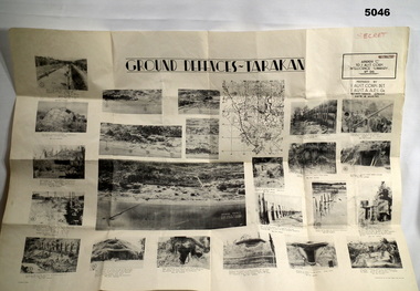 Bendigo Military Museum
Poster - POSTER, GROUND DEFENCES "TARAKAN", 1 Aust Corps Det. A.A.P.I. Gn, Ref map Tarakan 1/25000, 8 August 1945
Francis Hansen VX85668 2/3rd Infantry Battalion.Cream coloured Paper, Black Printed map with 23 photographs on it.Ground Defences Tarakanposter, photographs, tarakan -
 Marysville & District Historical Society
Map (Item) - Tourist Map, Tourists Resorts' Committee, Tourist's Map of Healesville Marysville and Warburton Districts, 13.10.1925
A tourist map for Healesville, Marysville and Warburton that was produced by the Tourists Resorts' Committee. This map was produced in 1925.A tourist map for Healesville, Marysville and Warburton that was produced by the Tourists Resorts' Committee.Photo Lithographed at the Department of Lands and Survey, Melbourne by W.J. Butson./ 13.10.25healesville, marysville, warburton, victoria, tourists resorts' committee, ben cairn, mount donna buang, the black's spur, the acheron valley, narbethong, launching place, tourist information, tourism, map, tourist map -
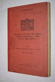 Wangaratta RSL Sub Branch
Manual - Book, Manual of Map Reading Photo Reading and Field Sketching, 1948
Official copy of War Office Manual of Map Reading Photo Reading and Field Sketching.Red bound book with black writing and British crest.Manual of Map Reading Photo Reading and Field Sketching 1929 The War Officemanual of map reading photo reading and field sketching., war office -
Stawell Historical Society Inc
Map - Electoral Map, Federal Government, map of Commonwealth Electoral Division of Wimmera 1949, 1949
Electoral MapMap overprinted with Electoral Divisions in Red. Description of Division of Wimmera Scale in Miles. Commonwealth of Australia State of Victoriagovernment -
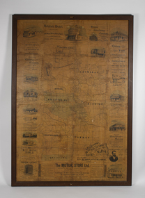
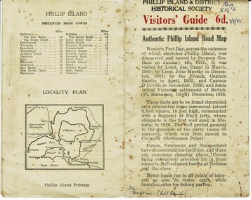 Phillip Island and District Historical Society Inc.
Booklet, Authentic Phillip Island Road Map, Pre 1960
Tourist brochure printed by the Phillip Island Printers pre 1960HistoricalSmall cream coloured brochure with details of accommodation, transport and animals. Inside is a map of the Island with numbered points of interest. There is also a plan of Cowes and drawings of animals.Visitors' Guide 6d Authentic Phillip Island Road Maptourist brochure, road map -
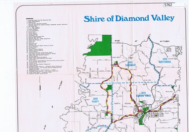 Greensborough Historical Society
Map, Map - Shire of Diamond Valley, 1990c
Map issued by the Shire of Diamond Valley showing location of key organisations and features Map printed in colour, one sideshire of diamond valley -
 Montmorency–Eltham RSL Sub Branch
Map - Framed 1915 Anzac Cove Map, Gallipoli, 1915.ANZAC Cove Map, 1915
A framed map depicting trench lines and the battlefields of the Gallipoli Campaign, 1915, made by the Survey Department Egypt. Depth soundings of landing areas off Anzac Cove.Gallipoli - Anzac Cove World War One Map - 1915world war one, anzac, gallipoli, 1915, anzac cove, map, dardenelles, trench lines, depth soundings, landing areas -
Whitehorse Historical Society Inc.
Map, Nunawading Map. Large Scale, 1960's ?
Sheet 2, Nunawading map. Sections 78 -97.Sheet 2, Nunawading map. Sections 78 -97.Sheet 2, Nunawading map. Sections 78 -97.maps, nunawading -
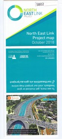 Greensborough Historical Society
Leaflet, North East Link Authority, North East Link: project map October 2018, 2018_10
North East Link Authority was set up to lead development of this project. This map shows the proposed route with major intersections/interchanges. Map, colour text and images.north east link -
 Bendigo Military Museum
Journal - Army Survey Regiment Map Store Distribution Register 1978-1986, 04.07.1978
This is a record of the maps that were despatched from the Army Survey Regiment Map Store 1978 - 1986Leather Bound "Minute Book", lined paper, hand written records of ASR Map distribution. royal australian survey corps, rasvy, fortuna, army survey regiment, army svy regt, asr -
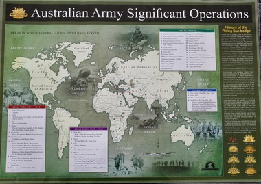 Lara RSL Sub Branch
Map - Areas in Which Australian Soldiers Have Served - World War 1 and World War 2 and Other Theatres (2 Off), Australian Army Significant Operations Map. (2 Off)
This map shows the areas in which Australian soldiers have served.Map of World showing Australian Armed Forces Theatre of Operations (Map)Rectangular in shape with a glossy front. (2 Off)Australian Army Significant Operationsaustralian army significant operations -
 Vision Australia
Photograph - Image, Ron Bruce reading Sydney Train map, 1971?
Ron Bruce reading a Braille map of Sydney's railway network.B/W photograph of man reading braille map1/71016 M&O -historicalroyal blind society of nsw, ron bruce, maps -
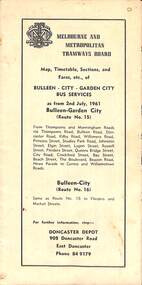 Melbourne Tram Museum
Map - Map, Timetable, Sections, and Fares, etc., of BULLEEN - CITY - GARDEN CITY BUS SERVICES
Map of the MMTB Bulleen - City - Garden City bus routes. Map, timetable & fares for Bulleen to City bus routemmtb, buses, doncaster, city -
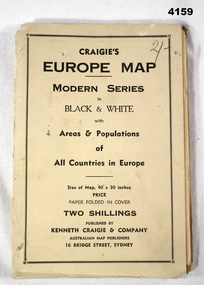 Bendigo Military Museum
Map - MAP of EUROPE, Craigie"s Europe Map, 1939
The map features the areas and populations of all European countries as per 1939. Part of the collection re Frederick Gardner Davey DFC No 410533 RAAF. Refer Cat No 3536P for his service details.Folded map in black and white. Coloured British and German flags are pinned to countries on the map.On the front cover in pencil, “2/-“. (2 schillings)maps, europe -
 Greensborough Historical Society
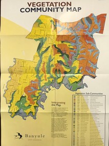
Maps, Vegetation Community Map, 2000c
Map and table of indigenous vegetation 'communities' in Banyule. Map & table, printed in colour both sides, folded to A4banyule city council, flora, vegetation, gum trees -
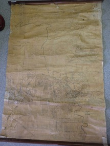 Greensborough Historical Society
Map, Map of Greensborough - Jessop's Real Estate, 1930c
This map of Greensborough hung in the office of Cec Jessop's Real Estate office corner Main and Grimshaw Street. Includes a word document listing street name changes from the original map to today, according to Norm Colvin.This map was saved from the building when the business closed.Canvas roll-up map with timber rails top and bottom.greensborough - maps, cecil jessop, greensborough street names -
 Vision Australia
Photograph - Image, Ron Goodwin reading a map of Wynyard train station, 1969?
Ron Goodwin reads a tactile map of Wynyard Railway Station in Sydney's CBD. The map was made at the Sydney Tesol College with wood working machinery and painting/decorating sections. In front of Ron sits a ultrasonic torch.B/W photograph of man looking at relief map of Wynyard Station14/69051 Ann. Report Orientation - historicalroyal blind society of nsw, ron goodwin, maps -
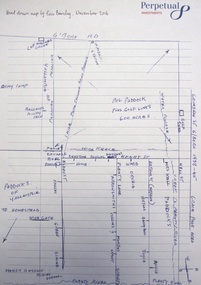 Greensborough Historical Society
Map - Digital Image, Eric Barclay's Grace Park map, November 2016, 2016_11
Eric Barclay's Grace Park map, November 2016. Eric recalls the area around Grace Park from the late 1940s.Digital copy of black and white maperic barclay, barclay family, grace park -
 Montmorency–Eltham RSL Sub Branch
Map - Framed 1915 map of Sulva Bay, Gallipoli, 1915 Map of Silva Bay, Gallipoli, 1915
This map was used in the Dardenelles Campaign 1915-1916.Framed map showing the Sulva Bay area of the Gallipoli battlefield in 1915.world war one, middle east, gallipoli, 1915, map, dardenelles, sulva bay, survey department, battlefields, egypt cairo -
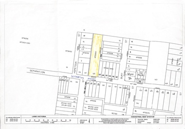 Whitehorse Historical Society Inc.
Map, 125 Separation Street, Northcote. Cadastral Map, 21/11/2001
A3 Cadastral Map of 125 Separation Street, Northcote August Schwerkolt purchased this property on 01/08/1853 where he lived and farmed the land, eventually purchasing the Mitcham property as well in 1861An A3 cadastral mapschwerkolt august