Showing 442 items matching "lands, victoria"
-
 Federation University Historical Collection
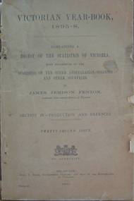
Book, Robert S. Brain, Government Printer, Victorian Year Book 1895-8, 1901
... system of Victoria, Crown lands, Agricultural statistics... of Victoria with reference to the other Australasian Colonies ...This year book was published in the year of Australian Federation. It was the 22nd issue of the Victorian Year BookBrown soft covered book of 1000 page. The book contains a digest of the statistics of Victoria with reference to the other Australasian Colonies and other countries. Topics include the land system of Victoria, Crown lands, Agricultural statistics, cultivation, industry, livestock, wool, dairy farms, cattle, rabbits, manufactures, alcohol production, mining, defense. Statistics were provided by J.J. Fenton, Assistant Government Statist. -
 Bendigo Historical Society Inc.
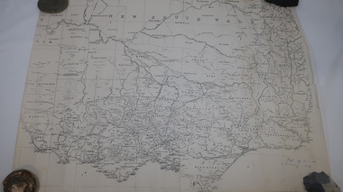
Map - MARONG : COUNTY OF BENDIGO, June 1953
... at the Department of Lands and Survey, Melbourne, Victoria. June 1953. Price... Printer. Drawn and reproduced at the Department of Lands ...Map. Marong, County of Bendigo, Nerring, Sandhurst, Lockwood, Shelbourne, Woodstock, Leichardt, Fletcher Creek, Bullock Creek, Township of Marong, Marong Railway Station, Bendigo Railway Line, Spring Creek, Crusoe Aqueduct. By authority W.M. Houston, Government Printer. Drawn and reproduced at the Department of Lands and Survey, Melbourne, Victoria. June 1953. Price 2/-. (number 73 in map cupboard 1)W.M. Houston, Government Printermap, bendigo, marong -
 Orbost & District Historical Society
Book - front cover, The Corringle Creek to Sydenham Inlet Coastal Reserve A RESOURCES STUDY, 1977
... by the Department of Crown Lands and Survey, Victoria 1977. Printed by James... of Orbost & the Dept. of Crown Lands & Survey with the purpose ...This 1977 Resources Study was a joint project of the Shire of Orbost & the Dept. of Crown Lands & Survey with the purpose of collating information on natural resources, pattern of public use, and constraints on future use so that management can be formulated.This report gives and understanding of the resources and management directions of coastal land in East Gippsland in 1977. A buff coloured cover with black printing and blue tape binding. 71 pages + maps/charts. THE CORRINGLE CREEK TO SYDENHAM INLET COASTAL RESERVE. A resources study with comment on the implications for management by IAN R. BROWN Research officer and PETER B. LAVERY Land Management Oficer. Coastal management Committee Victoria 1977. Published under the authority of the Coastal Management Committee by the Department of Crown Lands and Survey, Victoria 1977. Printed by James Yeates Printing, Bairnsdale 3875.corringle creek, sydenham inlet, natural resources survey -
University of Melbourne, Burnley Campus Archives
Plan, Royal Botanic Gardens Melbourne, 1978
... . of Crown Lands and Survey, Victoria, Division of Survey and Mapping.... of Crown Lands and Survey, Victoria, Division of Survey and Mapping ...Plan of RBG with grid references. Produced by Dept. of Crown Lands and Survey, Victoria, Division of Survey and Mapping. Prepared in 1978 from surveys completed in 1976. (1) 2 copies plan. Main areas, buildings, etc., labelled, beds outlined. (2) Original coloured plan and reduced size photocopy. More labelling, particularly beds (handwritten). Labelled Jeremy J. Wallace with handwritten notes on reverse re a project. (3) Reduced size photocopy. Handwritten labelling of beds. (4 - 11) Enlarged photocopies of sections of (1) Handwritten notes and plant labelling. (1). Photgraphed copies by FRESCO 510131-TA. (12) Plan on a grid, coloured. "No Public Access," areas marked.jeremy j. wallace, royal botanical gardens melbourne, department of crown land and survey division of survey and mapping, ornamental lakes -
 Flagstaff Hill Maritime Museum and Village
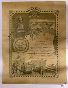
Award - Certificate of Service, F. W. Strahle, James Patten, 23-08-1907
... that was created by F. W. Strahle at the request of the Department of Lands... of the Department of Lands & Survey, Melbourne, Victoria. During his time ...This certificate acknowledges 21 years of service given by James Patten, one of the original 1859 Lifeboat Warrnambool as a boatman and bowman. At the time, all retiring Volunteer lifeboatmen were honoured with this award. It was made as a lithograph that was created by F. W. Strahle at the request of the Department of Lands & Survey, Melbourne, Victoria. During his time of service, James Patten was awarded a medal and certificate by the Royal Humane Society of Australasia for his bravery. Patten and his friend Joseph Lowe, who couldn't swim, were with their friend James Ferrier in a boat on the Hopkins River, Warrnambool, when their boat capsized. Ferrier made it to shore, and Patten tried unsuccessfully to hold onto Lowe and bring him to shore. The event occurred on 18th April 1890. The images on the Certificate show a collage of rescue events performed by the lifesavers; a shipwreck rescue in progress, lifeboat conveying five boatmen using two oars each, and a bowman standing at the bow, a linesman wearing a life jacket and holding a rescue line, a lifesaver ring with images of three sailing ships inside it, a shipwreck near shore, a woman and girl in shallow water, a rescue using a breeches buoy on the lifeline, two rescuers walking towards the survivor, rescue crew wearing waterproof clothing, a rocket machine with a pulley to bring the survivor in a breaches buoy to shore, and a rescue crew member holding a flare. Volunteers at the time received a small payment, or 'retainer'', for their practices and a payment of gratitude for the rescues they attended. Across the years between 1856 to 1979 the combined service in Victoria saved 260 lives. Amazingly, some of the volunteers could not even swim.This certificate shows the State and Local Government's appreciation for the years of service spent by in the endeavour to save lives in peril in and on the local waters in the early 20th Century. The lithographed design depicts the many skills and services performed by the lifesavers of the era.Certificate of Service, unframed, awarded to James Patten on 23rd August 1907, recognising his 21 years of service with the original Warrnambool Life Boat Service as a Boatman and Bowman. Certificate is on rectangular, cream paper, lithographed design, printed and handwritten. Letterhead with the Royal Coat of Arms of the United Kingdom and a French motto. Images depict lifesaving crew, lifeboat, rescue equipment and a rescue in progress. The border is waves inside of frame of looped rope. Signatures of Commissioner of Public Works, Secretary of Public Works, and Engineer in charge of Ports and Harbours, Melbourne. Printed from a lithograph produced by F.W. Strahle on 23rd June 1907.MOTTO: "Dieu Droit Et Mon, Ni Soit Qui Mal y" TREXT: "Certificate granted to James Patten as a mark of appreciation of his esteemed services of 21 years as Boatman and Bowman connected with the Departmental Life-Boat service at Warrnambool - dated the 23rd day of August 1907." SIGNATURES: [Commissioner of Public Works], [Secretary of Public Works], [Engineer in charge of Ports and Harbours Melbourne] "Lithographed at the Dept of Lands & Survey - Melb/ by F.W. Strahle, 23.6.07"flagstaff hill, warrnambool, flagstaff-hill, maritime museum, maritime village, shipwreck-coast, flagstaff hill maritime museum & village, james patten, life-saving, lifesaving, rescue, bravery, drowning, joseph lowe, james ferrier, hopkins river, boat accident, certificate of service, 1890, 1907, bowman, boatman, departmental life-boat service, life-boat service, lifeboat service, august 1907, commissioner of public works, public works, ports and harbours melbourne, lands & survey melbourne, f w strahle, lithograph, 1856-1979, 260 lives saved, victorian volunteers, lifeboatmen, retired lifeboatmen -
 Eltham District Historical Society Inc
Photograph, Fay Bridge, Ancient Eel trap on the Yarra River at Laughing Waters, Eltham - pre-dating European settlement, 6 September 2023
... of the reasons for its survival. The iuk trap is located within lands... of the reasons for its survival. The iuk trap is located within lands ...Laughing Waters is the name for a stretch of the Yarra Valley Parklands consisting of river flats and hilly riparian bushland. With Birrarung (Yarra River) flowing through, Laughing Waters has been an important gathering place for thousands of years. For the Wurundjeri, ‘Garambi Baan’ (the name for Laughing Waters in Woi wurrung) is an important site for growing and harvesting food. Significantly, Wurundjeri iuk (eel) traps remain at Garambi Baan to this day. The Wurundjeri Woi Wurrung People take their name from the Woi wurrung language word ‘wurun’ meaning the Manna Gum (Eucalyptus viminalis) which is common along ‘Birrarung’ (Yarra River), and ‘djeri’, the grub which is found in or near the tree. Wurundjeri are the ‘Manna Gum People’ and their Ancestors have lived on this land for millennia. The site on the Yarra River near the former Morrison property Killeavey was given a language name in 2015 at the instigation of Wurundjeri Elder, Dave Wandin. Garambi Baan means “laughing waters” in the traditional language, Woi wurrung. The site at Warrandyte was rediscovered by Campbell Beardsell OAM in 2007 and is one of only a few known remaining iuk (eel) traps on Country once found the length of the Birrarung (Yarra) and the Maribyrnong. Original Indigenous aquacultural infrastructure was dismantled, taken away from sites and used to build houses, fords and roads by Europeans. The difficult and restricted access to this site is thought to be one of the reasons for its survival. The iuk trap is located within lands managed by Parks Victoria. The Narrap team in partnership with Parks Victoria and Acacia Land Management have been improving the native vegetation with a program of woody weed removal, exclusion fencing and revegetation. Importantly, the team have restored the trap’s infrastructure and have demonstrated its effectiveness.” References: Wurundjeri Woi Wurrung Cultural Heritage Aboriginal Corporation - Laughing Waters. (2023, September 3). Retrieved from https://inplace.org.au/laughing-waters/ GARAMBI BAAN LAUGHING WATERS RESIDENCY CENTRE 2020 2024 Strategic Plan, Nillumbik Shire Council (2023, September 3). Retrieved from https://www.nillumbik.vic.gov.au/files/assets/public/minutes-and-agendas/2020/09-sep/15-sep-cm/ocm.177-20-attachment-1-laughing-waters-arts-program_1.pdffay bridge collection, eel trap, laughing waters, yarra river, wurundjeri woi wurrung, garambi baan, 2023-09-06 -
 Eltham District Historical Society Inc
Photograph, Fay Bridge, Ancient Eel trap on the Yarra River at Laughing Waters, Eltham - pre-dating European settlement, 16 May 2015
... of the reasons for its survival. The iuk trap is located within lands... of the reasons for its survival. The iuk trap is located within lands ...Laughing Waters is the name for a stretch of the Yarra Valley Parklands consisting of river flats and hilly riparian bushland. With Birrarung (Yarra River) flowing through, Laughing Waters has been an important gathering place for thousands of years. For the Wurundjeri, ‘Garambi Baan’ (the name for Laughing Waters in Woi wurrung) is an important site for growing and harvesting food. Significantly, Wurundjeri iuk (eel) traps remain at Garambi Baan to this day. The Wurundjeri Woi Wurrung People take their name from the Woi wurrung language word ‘wurun’ meaning the Manna Gum (Eucalyptus viminalis) which is common along ‘Birrarung’ (Yarra River), and ‘djeri’, the grub which is found in or near the tree. Wurundjeri are the ‘Manna Gum People’ and their Ancestors have lived on this land for millennia. The site on the Yarra River near the former Morrison property Killeavey was given a language name in 2015 at the instigation of Wurundjeri Elder, Dave Wandin. Garambi Baan means “laughing waters” in the traditional language, Woi wurrung. The site at Warrandyte was rediscovered by Campbell Beardsell OAM in 2007 and is one of only a few known remaining iuk (eel) traps on Country once found the length of the Birrarung (Yarra) and the Maribyrnong. Original Indigenous aquacultural infrastructure was dismantled, taken away from sites and used to build houses, fords and roads by Europeans. The difficult and restricted access to this site is thought to be one of the reasons for its survival. The iuk trap is located within lands managed by Parks Victoria. The Narrap team in partnership with Parks Victoria and Acacia Land Management have been improving the native vegetation with a program of woody weed removal, exclusion fencing and revegetation. Importantly, the team have restored the trap’s infrastructure and have demonstrated its effectiveness.” References: Wurundjeri Woi Wurrung Cultural Heritage Aboriginal Corporation - Laughing Waters. (2023, September 3). Retrieved from https://inplace.org.au/laughing-waters/ GARAMBI BAAN LAUGHING WATERS RESIDENCY CENTRE 2020 2024 Strategic Plan, Nillumbik Shire Council (2023, September 3). Retrieved from https://www.nillumbik.vic.gov.au/files/assets/public/minutes-and-agendas/2020/09-sep/15-sep-cm/ocm.177-20-attachment-1-laughing-waters-arts-program_1.pdffay bridge collection, 2015-05-16, eel trap, laughing waters, yarra river, wurundjeri woi wurrung, garambi baan -
 The Beechworth Burke Museum
Photograph, c1970
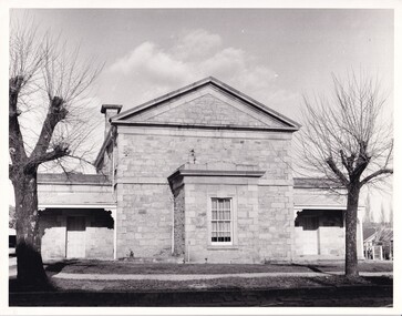
The Beechworth Historic Courthouse is a living history museum in Victoria, Australia. Built in 1858, it has been in continuous service for 131 years and is currently home to a unique collection of artifacts, including its original furniture and fittings. The Courthouse Law Library is also recognised as being of outstanding national significance with many rare books held in the collection. The courthouse was built in 1858 and is located in the centre of the Beechworth Historic Precinct. It was built from granite with a double height gabled courtroom with the entrance via a central projecting porch. The building was classified in 1959 as part of Group Classification (B2615)with Forests Office, Lands Office, Police Lock-up & Police Station. The Courthouse is a significant site in Australia’s legal history because it was the location of more than 40 trials and hearings for the Kelly Gang and their sympathisers.This a rectangular, black and white photograph, unmounted.Reverse Ministry of Tourism, Melbourne1850s beechworth, beechworth courthouse, ned kelly, 1800s beechworth, kelly gang, beechworth historic courthouse, 1858, kelly trials, daniel kelly, dan kelly, edward kelly, ellen kelly, elizabeth scott, the first woman hanged in victoria, colony of victoria, 1863, domestic violence related murder -
 The Beechworth Burke Museum
Photograph
The photograph depicts two young men standing atop a prominent outcrop at Lake Sambell, with buildings visible on the further shore. The present day park and reserve occupies the site of the former Rocky Mountain Mining Company, an open-cut sluice mine that began operations in the mid-Nineteenth Century and operated until the early 1900s, through the peak of Victoria’s Gold Rush. It was converted into a park and leisure area in the 1920s. Lake Sambell was formally opened to the public on Friday 5th October 1928 and was opened by the Victorian Government’s Minister of Lands, Mr Bailey, as part of initiatives to boost the economies and development of country towns. The lake was named after Mr L.H. Sambell, a shire engineer and secretary of the Forward Beechworth Committee who was involved in promoting the transformation of the mining site and promoting plantation forestry and tourism as alternative industries. £300 to begin the process was provided by Mr J. McConvill, a former resident of Beechworth, who is remembered in a street name adjacent to the lake. An article in the Ovens and Murray Advertiser on Saturday, 5th May, 1917, gives some insight into issues in the Rocky Mountain Mining Company’s final years. The writer details the 1917 annual meeting of the Rocky Mountain Mining Company, stating that locals present appeared ‘well pleased this important local industry is in such a prosperous condition and that future prospects are so encouraging’. The author describes plans to give workers a bonus as evidence of profit-sharing that would ‘bridge the gulf between capital and labour’. The article concludes, however, with the statement that ‘there is a little arithmetical puzzle in the report in connection with the dredging operations I have been unable to solve.' The photograph is significant as it contributes to knowledge about how Beechworth reinvented itself after the Gold rush period, and more broadly how country towns repurpose and redevelop infrastructure and facilities to meet the present needs of their population. Sepia rectangular photograph printed on matte photographic paper. Obverse: nil. Reverse: 3471 / Velox (paper mark)beechworth, beechworth lake, lake sambell, l.h. sambell, mcconvill, rocky mountain mining company, rocky mountain mining co, minister of lands, forward beechworth committee, wallace park-lake sambell development scheme, wallace park lake sambell development scheme, lake, sambell, j. mcconvill, recreation, reserve, park, transformation, repurposed, redeveloped -
 The Beechworth Burke Museum
Photograph, c1960
The photograph depicts a view across the water at Lake Sambell. The image dates from approximately 1960. The present day park and reserve occupies the site of the former Rocky Mountain Mining Company, an open-cut sluice mine that began operations in the mid-Nineteenth Century and operated until the early 1900s, through the peak of Victoria’s Gold Rush. It was converted into a park and leisure area in the 1920s. Lake Sambell was formally opened to the public on Friday 5th October 1928 and was opened by the Victorian Government’s Minister of Lands, Mr Bailey, as part of initiatives to boost the economies and development of country towns. The lake was named after Mr L.H. Sambell, a shire engineer and secretary of the Forward Beechworth Committee who was involved in promoting the transformation of the mining site and promoting plantation forestry and tourism as alternative industries. £300 to begin the process was provided by Mr J. McConvill, a former resident of Beechworth, who is remembered in a street name adjacent to the lake. Residents of Beechworth have worked to raise funds to improve the Lake Sambell reserve several times, such as efforts in the 1930s and 1940s to raise the banks several feet to deepen the water for swimming purposes. Fundraising campaigns include the ‘Ugly Man’ competition conducted on behalf of the Wallace Park-Lake Sambell Development Scheme. The latter competition was run by the Fire Brigade Bend’s team as part of a larger competition called the ‘Mile of Pennies’; it was won by Mr Len Knight of Beechworth’s Commercial Hotel. The ‘Mile of Pennies’ was conducted at a Carnival held on New Year’s Eve, 1947. It was proposed by the Beechworth and District Progress Association. As well as improving swimming facilities, funds were raised to install a caravan park facility near the lake. Funds were also donated by commercial entities, such as £250 received from Zwar Bros. Pty Ltd. The photograph is significant as it shows the level of development of Beechworth in the early to mid-Twentieth Century. Sepia rectangular photograph printed on matte photographic paperObverse: nil. Reverse: 3470 / Velox (paper mark)beechworth, beechworth lake, lake sambell, lake, beechworth and district progress association, forward beechworth committee, ugly man, mile of pennies, wallace park lake sambell development scheme, wallace park-lake sambell development scheme, zwar bros, zwar, l.h. sambell, j. mcconvill, minister of lands, commercial hotel, len knight, rocky mountain mining company, rocky mountain mining co, gold rush, redevelopment, transformation, community fundraising -
 The Beechworth Burke Museum
Photograph, c1960
The photograph depicts a view across the water at Lake Sambell. The image is thought to date from the 1960s so may show the lake during a period of drought, such as that experienced across South-Eastern Australia in 1967. The present day park and reserve occupies the site of the former Rocky Mountain Mining Company, an open-cut sluice mine that began operations in the mid-Nineteenth Century and operated until the early 1900s, through the peak of Victoria’s Gold Rush. It was converted into a park and leisure area in the 1920s. Lake Sambell was formally opened to the public on Friday 5th October 1928 and was opened by the Victorian Government’s Minister of Lands, Mr Bailey, as part of initiatives to boost the economies and development of country towns. The lake was named after Mr L.H. Sambell, a shire engineer and secretary of the Forward Beechworth Committee who was involved in promoting the transformation of the mining site and promoting plantation forestry and tourism as alternative industries. £300 to begin the process was provided by Mr J. McConvill, a former resident of Beechworth, who is remembered in a street name adjacent to the lake. Residents of Beechworth have worked to raise funds to improve the Lake Sambell reserve several times, such as efforts in the 1930s and 1940s to raise the banks several feet to deepen the water for swimming purposes. Fundraising campaigns include the ‘Ugly Man’ competition conducted on behalf of the Wallace Park-Lake Sambell Development Scheme. The latter competition was run by the Fire Brigade Bend’s team as part of a larger competition called the ‘Mile of Pennies’; it was won by Mr Len Knight of Beechworth’s Commercial Hotel. The ‘Mile of Pennies’ was conducted at a Carnival held on New Year’s Eve, 1947. It was proposed by the Beechworth and District Progress Association. As well as improving swimming facilities, funds were raised to install a caravan park facility near the lake. Funds were also donated by commercial entities, such as £250 received from Zwar Bros. Pty Ltd.The photograph is significant as it shows Lake Sambell at lower water levels, such as may have been experienced during period of drought.Sepia rectangular photograph printed on matte photographic paperObverse: nil Reverse: 3470beechworth, beechworth lake, lake sambell, lake, beechworth and district progress association, forward beechworth committee, ugly man, mile of pennies, wallace park lake sambell development scheme, wallace park-lake sambell development scheme, zwar bros, zwar, l.h. sambell, j. mcconvill, minister of lands, commercial hotel, len knight, rocky mountain mining company, rocky mountain mining co, gold rush, redevelopment, transformation, community fundraising, drought, 1967, 1960s -
 The Beechworth Burke Museum
Photograph, c1960
The photographs in this set depict views across the water at Lake Sambell. The images date from approximately 1960. The present day park and reserve occupies the site of the former Rocky Mountain Mining Company, an open-cut sluice mine that began operations in the mid-19th Century and operated until the early 1900s, through the peak of Victoria’s Gold Rush. It was converted into a park and leisure area in the 1920s. Lake Sambell was formally opened to the public on Friday 5th October 1928 and was opened by the Victorian Government’s Minister of Lands, Mr Bailey, as part of initiatives to boost the economies and development of country towns. The lake was named after Mr L.H. Sambell, a shire engineer and secretary of the Forward Beechworth Committee who was involved in promoting the transformation of the mining site and promoting plantation forestry and tourism as alternative industries. £300 to begin the process was provided by Mr J. McConvill, a former resident of Beechworth, who is remembered in a street name adjacent to the lake. Residents of Beechworth have worked to raise funds to improve the Lake Sambell reserve several times, such as efforts in the 1930s and 1940s to raise the banks several feet to deepen the water for swimming purposes. Fundraising campaigns include the ‘Ugly Man’ competition conducted on behalf of the Wallace Park-Lake Sambell Development Scheme. The latter competition was run by the Fire Brigade Bend’s team as part of a larger competition called the ‘Mile of Pennies’; it was won by Mr Len Knight of Beechworth’s Commercial Hotel. The ‘Mile of Pennies’ was conducted at a Carnival held on New Year’s Eve, 1947. It was proposed by the Beechworth and District Progress Association. As well as improving swimming facilities, funds were raised to install a caravan park facility near the lake. Funds were also donated by commercial entities, such as £250 received from Zwar Bros. Pty Ltd.The photographs are significant as they show the level of development in Beechworth in the middle of the Twentieth Century. Four sepia and black and white rectangular photographs printed on matte photographic paper. 3469.1: Obverse: nil Reverse: 3469-1 3469.2: Obverse: nil Reverse: 3469-2 3469.3: Obverse: nil Reverse: 3469-3 3469.4: Obverse: nil Reverse: 3469-4beechworth, beechworth lake, lake sambell, lake, beechworth and district progress association, forward beechworth committee, ugly man, mile of pennies, wallace park lake sambell development scheme, wallace park-lake sambell development scheme, zwar bros, zwar, l.h. sambell, j. mcconvill, minister of lands, commercial hotel, len knight, rocky mountain mining company, rocky mountain mining co, gold rush, redevelopment, transformation, community fundraising -
 Orbost & District Historical Society
framed photo, APFA- Davisigns (PG & ME Davis)
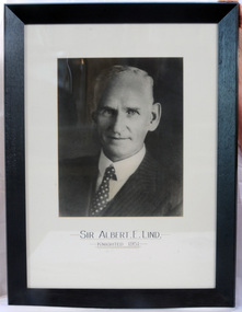
This photo was inherited with the building when the museum was established. Lind was born in 1878 in East Charlton, Victoria, the son of Oliver Nicholas Lind, a farmer from Denmark, and his Welsh wife Mary Ann Clay. In 1882, drought forced the family to move to East Gippsland where Lind was educated at Lucknow, and then to Bairnsdale in 1884 where he attended Bairnsdale state school. In October 1920, he was elected to the Victorian Legislative Assembly for the seat of Gippsland East for the Victorian Farmers' Union. Lind was made Minister of Forests, President of the Board of Land and Works and Commissioner of Crown Lands and Survey in Albert Dunstan's cabinet. He was knighted in 1951. In 1926 two national parks east of Orbost were named the Albert and the Lind national parks after him.A framed photo of Sir Albert Eli Lind. It is a black and white head and shoulders photo in a black wooden frame.Sir Albert E. Lind Knighted !951photograph politician lind-albert government -
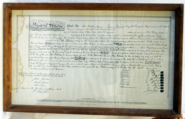 Orbost & District Historical Society
framed document, Batman's Melbourne Deed, 1966
The Batman Deed is sometimes called the Batman Treaty, the Dutigullar Deed, the Dutigullar Treaty or the Melbourne Deed. The deeds had been drafted by JT Gellibrand, a leading lawyer in the colony. Batman's Treaty was a document signed on 6 June 1835 by John Batman, an Australian grazier, businessman and explorer, and a group of Wurundjeri elders, for the purchase of land around Port Phillip, near the present site of the city of Melbourne. The document came to be known as Batman's Treaty and is considered significant as it was the first and only documented time when Europeans negotiated their presence and occupation of Aboriginal lands directly with the traditional owners. The so-called treaty was implicitly declared void on 26 August 1835 by the Governor of New South Wales, Richard Bourke. The original Batman Deed is of enormous significance to the history of the European settlement of Victoria. Framed print of the Batman Deed, dated 1835. This is a printed copy of the Batman Deed, made in 1966 from the 'original' by the State Library of Victoria. The frame is wood. The document consists of handwritten text in black ink with eight signatures in the lower right hand side and three signatures in the lower left hand corner. It has been signed by John Batman beneath the eight signatures.document batman-deed melbourne -
 Ringwood and District Historical Society
Photograph, Composite Aerial Views of Ringwood, Victoria - 1972
Two composite black & white aerial photographs with north-facing view over Maroondah Highway, including Railway Station precinct, Civic Centre precinct, Eastland, Mount Dandenong Road, Bedford Road, Ringwood Street, Warrandyte Road, Mullum Road, Loughnan's Road.Department of Crown Lands and Survey. Maroondah Highway Project - Run 3 - 20.1.72 - 3,900' ASL. -
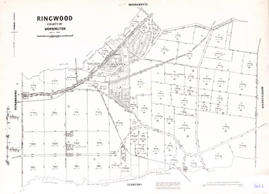 Ringwood and District Historical Society
Map - Parish of Ringwood, County of Mornington, Victoria, Original Land Owners
Laminated Parish map of Ringwood detailing original Land Owners' names, property locations and acreages. Details reproduced in 1957 by the Department of Lands and Survey, Melbourne, from original surveys of varying dates. -
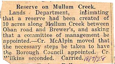 Ringwood and District Historical Society
Newspaper, Scrapbook Clipping, Library Collection, Ringwood, Victoria
Newspaper Clipping from un-named local paper re Reserve on Mullum Creek, category of PARKS, GARDENS, RESERVES. Dated 18-7-1928Lands Department, intimating that a reserve had been created of 10 acres along Mullum Creek between Oban Road and Brewer's, and asking that a committee of management be appointed. -- Cr. McAlpin moved that the necessary steps be taken to have the Borough Council appointed. Cr. Wilkins seconded. Carried. -
 Orbost & District Historical Society
black and white photograph, 1913
This photograph shows Country Roads Board men clearing a bush track at Hospital Creek. Their vehicle was bogged. The y Roads Board was formed in 1913 1910 it had become apparent that there was a need for a central roads authority to take over responsibility from the Board of Lands and Works for the care and management of the main roads of the state of Victoria. Because there was no consistent and systematic policy for road maintenance Victorian roads were in a deplorable condition. At this time the use of the motor car accentuated the demands for better roads. As a result of these needs the Country Roads Act 1912 was proclaimed in 1913 providing for the establishment of the Country Roads Board as a central road authority with responsibility for those roads within the State considered to be main roads. the C.R.B. was responsible for the construction of roads and bridges including the Snowy River road bridges in Orbost.. This is a pictorial record of transport difficulties in East Gippsland in early 20th century.A large black / white photograph of three men clearing a bush track with a motor vehicle behind them.transport roads road-maintenance country-roads-board -
 Ringwood and District Historical Society
Map, Allotments - Township of Ringwood - Parish of Ringwood - County of Mornington - 1886, 1886
[Page 3, Horse Shoes to High Heels - Richard Carter] ... "(In the year 1882) the railway was extended from Hawthorn through Ringwood to Lilydale and later to Ferntree Gully." Linen-backed map of Ringwood area lithographed at the Department of Lands and Survey, Melbourne, 5th November, 1886.old lilydale road, new lilydale road, victoria brick and tile co., ringwood brick co., federal brick co. -
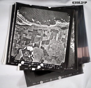 Bendigo Military Museum
Photograph - Aerial Photography - Mohogany Ship Search Warrnambool Victoria, Victorian Lands Department, 3.1.1981
... goldfields These Victorian Lands Dept Aerial Photographs were ...These Victorian Lands Dept Aerial Photographs were acquired by the Army Survey Regiment to help locate a Mohogany Ship wreck near Warrnambool Victoria as part of a unit Regimental Training ExerciseSeven Aerial photographic Prints and Film Negatives and positives of the same images. Images are Numbered 3562- 15,16,17,18,19, 29 and 30.royal australian survey corps, rasvy, fortuna, army survey regiment, army svy regt, asr -
 Kiewa Valley Historical Society
Maps of Victoria
Three maps: copies from the 19th century. 1. Handwritten 'Dept of Lands & Survey 1876'. 2. Map of the Ovens & Murray District, Victoria with handwritten 'F.H. Hiscock & Co's, New Victoria Countries Atlas 1874'. 3. Map of the Murray and Gipps Land Distr' with handwritten: "Baillieu's County Atlas of Victoria 1866'.maps of victoria, 19th century, oven and murray district of victoria -
 Warrnambool and District Historical Society Inc.
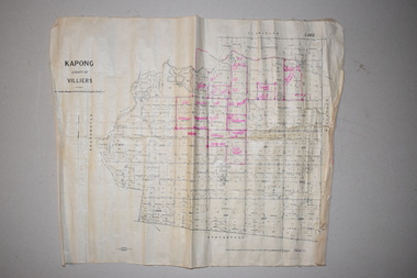
Maps (2), 1 Kapong .2 Hawkesdale, 1 1913 .2 1942
... These two maps of the Kapong/ Hawkesdale area in Victoria... maps of the Kapong/ Hawkesdale area in Victoria show ...These two maps of the Kapong/ Hawkesdale area in Victoria show the original lands that belonged to the pioneer settler, Charles Hamilton MacKnight and the handwritten annotations that show the subsequent owners of these lands. Charles Hamilton Macknight (1819-1873) came to Australia from Scotland in 1841 and in 1842, with partners, James Irvine and William Campbell, established the property of Dunmore in Broadwater (24 kilometres from Hawkesdale). He was a prominent breeder of sheep, cattle and horses. Sections of his lands were acquired by the Baulch family and these maps were acquired from a member of the Baulch family, with Stanley Baulch being the possible annotator of the Kapong map. These maps are of interest as they show the properties that belonged to the pioneer settler, Charles Hamilton MacKnight and the subsequent division of these lands, some of these passing into the hands of the Baulch family. As the Kapong map also shows other original landowners, it will be a useful tool for researchers..1 This is a map of Kapong in the County of Villiers. It is on a rectangular-shaped piece of linen-backed paper with black printing and some handwritten annotations in red ink. It is crumpled at the edges. .2 This is a rectangular-shaped piece of paper showing a map of the Hawkesdale area. The printed material is in grid form in black, green and red. At the left bottom edge it has a mauve stamp. kapong, victoria, hawkesdale, victoria, dunmore estate, victoria, charles hamilton macknight, baulch family, western victoria, history of warrnambool -
 Eltham District Historical Society Inc
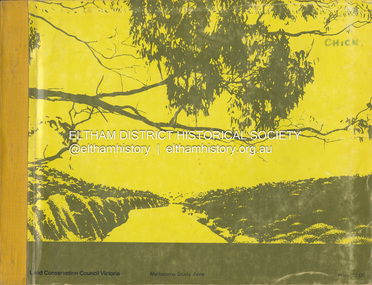
Book, Land Conservation Council, Report on the Melbourne Study Area, December 1973
This report is one of a series describings the physical nature of the land and its environment, examines the likely forms of land use, and assesses the hazards associated with these uses. It is divided into four main sections: Introduction, Characteristics of environment, main forms of land use and description of 24 specific blocks in the study area which include Torquay, Brisbane Ranges, Werribee, Wombat, Loddon, Romsey, Puckapunyal, Strathbogie, Eildon, Disappointment, Break O'Day, Black Range, Cerberean, Upper Goulburn, Kinglake, Donna Buang, Upper Yarra, Thomson, Dandenongs, Bunyip-Latrobe, Shady Creek, Tyers, Westernport and Strzelecki. The Land Conservation Act 1970 established the Land Conservation Council whose functions is to "carry out investigations and make recommendations to the Minister with respect to the use of public land in order to provide for the balanced use of land in Victoria. This report sets out to describe and assess the natural resources of the public lands in the Melbourne area and provides a factual basis on which members of the community may base submissions to the [Land Conservation] Council of Victoria.444 pagesnon-fictionThis report is one of a series describings the physical nature of the land and its environment, examines the likely forms of land use, and assesses the hazards associated with these uses. It is divided into four main sections: Introduction, Characteristics of environment, main forms of land use and description of 24 specific blocks in the study area which include Torquay, Brisbane Ranges, Werribee, Wombat, Loddon, Romsey, Puckapunyal, Strathbogie, Eildon, Disappointment, Break O'Day, Black Range, Cerberean, Upper Goulburn, Kinglake, Donna Buang, Upper Yarra, Thomson, Dandenongs, Bunyip-Latrobe, Shady Creek, Tyers, Westernport and Strzelecki. The Land Conservation Act 1970 established the Land Conservation Council whose functions is to "carry out investigations and make recommendations to the Minister with respect to the use of public land in order to provide for the balanced use of land in Victoria. This report sets out to describe and assess the natural resources of the public lands in the Melbourne area and provides a factual basis on which members of the community may base submissions to the [Land Conservation] Council of Victoria.land use, kinglake, thomson valley, conservation, public lands -
![Book - Map, Land Conservation Council, Melbourne Study Area Report, [December 1973]](/media/collectors/4f729f7b97f83e03086018a5/items/6469bc241d76dd4b008a829f/item-media/646b0013d841f8920fa4323c/item-fit-380x285.jpg) Eltham District Historical Society Inc
Eltham District Historical Society IncBook - Map, Land Conservation Council, Melbourne Study Area Report, [December 1973]
The Melbourne Study Report is a series of volumes describing the physical nature of the land and its environment, examines the likely forms of land use, and assesses the hazards associated with these uses. This is Volume 2 (coloured maps). The first page featues a black and white map described as "Shire of Diamond Valley" with public land marked in yellow. Followed by eight large fold out maps. Melbourne Study Area Public land and descriptive blocks, Population description, Geology, Physiography, topography and rainfall, vegetation and water supply. The Land Conservation Act 1970 established the Land Conservation Council whose functions is to "carry out investigations and make recommendations to the Minister with respect to the use of public land in order to provide for the balanced use of land in Victoria. This report sets out to describe and assess the natural resources of the public lands in the Melbourne area and provides a factual basis on which members of the community may base submissions to the [Land Conservation] Council of Victoria.A collection of eight large fold out coloured maps published in a bound book formnon-fictionThe Melbourne Study Report is a series of volumes describing the physical nature of the land and its environment, examines the likely forms of land use, and assesses the hazards associated with these uses. This is Volume 2 (coloured maps). The first page featues a black and white map described as "Shire of Diamond Valley" with public land marked in yellow. Followed by eight large fold out maps. Melbourne Study Area Public land and descriptive blocks, Population description, Geology, Physiography, topography and rainfall, vegetation and water supply. The Land Conservation Act 1970 established the Land Conservation Council whose functions is to "carry out investigations and make recommendations to the Minister with respect to the use of public land in order to provide for the balanced use of land in Victoria. This report sets out to describe and assess the natural resources of the public lands in the Melbourne area and provides a factual basis on which members of the community may base submissions to the [Land Conservation] Council of Victoria. maps, shire of diamond valley, population, geology, topography, rainfall, vegetation, water supply, land use, public lands -
 Eltham District Historical Society Inc
Document - Folder, Wellers of Kangaroo Ground, 1984-2017
Wellers of Kangaroo Ground Vertical File Contents: 1. Article: History of Wellers Restaurant by Sandra Cahir, revised 2017. 7 pages 2. Article: Weller’s Hotel of Kangaroo Ground (final draft) by Jim Allan, 1 June 2017, including feedback email from Sandra Cahir (7 May 2017). 3. Printout of online image - Kangaroo Ground landholders from 1841, Kangaroo Ground Presbyterian Church. (2022, June 29). Retrieved from https://kgpc.pcvic.org.au/images/history_images/Kangaroo-Ground-landholders.jpg 4. Folder of printouts of historical newspaper articles referencing the hotel 1866-1911 https://trove.nla.gov.au/list/163201 5. Printouts (various versions) from Victorian Heritage Database (National Trust and Nillumbik Shire) https://vhd.heritagecouncil.vic.gov.au/ 6. Collection of research notes, copies of records from various publications including EDHS Chronology of Events and Kangaroo Ground: The Highland Taken by Mick Woiwod, pp90, 180-181 (EDHS_01618). 7. Report: Request for ministerial amendment to use the property as a restaurant, includes existing conditions and plan for development, 1 November 1984 8. Papers donated by Diana and Peter Bassett-Smith including: a. Photocopy of Weller’s Hotel, Licensee M. Weller b. Letter: Shire of Eltham to Office of the Secretary for Planning and Environment, 23 Feb 1984 - Information regarding inclusion of Wellers Hotel into the Historic Buildings Register c. Letter: Historic Buildings Council letter to Peter Bassett-Smith seeking historical information on Wellers Hotel, 10 Jan 1985 d. Memo: Peter Bassett-Smith to Robert N. Hendrey on history of Wellers Hotel, 28 Jan 1985 - Includes extract of information about Mary Weller, Dept. of Crown Lands and Survey Map NILLUMBIK showing properties of John Weller and E. Weller and a Diamond Valley News article from 10 April 1973, p11, "Eltham on old coach route" 9. Information about the Weller family including family trees from various sources a. Edward Weller, Pioneer Families in Victoria, http://mepnab.netau.net/w/w09.html, 1 Jan 2017 (link broken) b. The WELLER family tree. (2017, January 1), 2 pages. Retrieved from https://www.weller.org.uk/cgi-bin/FamilyTree/ShowFamily.pl? and 27 pages Retrieved from https://www.weller.org.uk/cgi-bin/FamilyTree/ShowFamily.pl?ListAllPeople=A c. Edward WELLER on the WELLER family tree. (2017, January 1), 1 page. Retrieved from https://www.weller.org.uk/cgi-bin/FamilyTree/ShowFamily.pl?PersonID=516 d. Photograph (print copy), believed to be Edward Weller, 1836-1883 e. Photograph (print copy), Gravestone of Weller family at Kangaroo Cemetery f. Wellers of Kangaroo Ground, 1 page, possibly from History, http://www.wellers.com.au (broken) c.2016 g. Edward and Mary Weller miscellaneous biographical research notes (by Jim Allen?) including from Ancestry.com, and extracts from Chappel file (EDHS_04448) with relevant names highlighted h. Information about the Vernon Pitman family from Ancestry.com 10. Newspaper articles: a. Cobb & Co called here by Marguerite Marshall; Diamond Valley News, May 4, 1982, p2 b. Rich is history, 30 August 1983 (very similar to previous article) c. Weller’s Pub - restaurant, craft store or art gallery? Diamond Valley News, October 22, 1985, p3 d. Despite years of neglect a magical charm lies waiting, Diamond Valley News, October 29, 1985 e. Old pub fate still in doubt, Diamond Valley News, (?) 29 October 1985 f. Renovated Weller’s Pub to begin its new stage of life, DVN 26 January 1988 g. Wellers Restaurant, Lynne Hillier, Network, October 1988, p14 h. Revolution at Wellers, Nillumbik Mail, December 20, 2000 i. Wellers brings on good times, Valley Weekly, June 22, 2005 j. Dine in with ideal outlook, Valley News, 10 August 2005 k. Advertisement: Wellers of Kangaroo Ground, Enjoy lunch, afternoon tea and dinner at Wellers from Tuesday to Sunday, Valley Weekly, Wednesday, August 31, 2005 l. Advertisement: Wellers of Kangaroo Ground, Appearing live; Normie Rowe Fri 24 Feb, Diamond Valley Leader February 22, 2006, p11 m. Advertisement: Wellers of Kangaroo Ground, Lunch Special, Diamond Valley Leader March 27, 2010 n. Braithwaite abounds to Kangaroo Ground, Gig Guide, The Age, Friday, October 8, 2010, p14 o. History up for grabs, Diamond Valley Leader, March 28, 2012 p. Advertisement: Wellers Restaurant, Freehold only for sale, Morrison Kleeman, Diamond Valley Leader, March 28, 2012 q. Restaurant’s crash course, Megan Bailey, Diamond Valley Leader, January 1, 2014, p3. Also accessible online - Staff praised after car crashes through Kangaroo Ground eatery. (2022, June 29). Retrieved from https://www.heraldsun.com.au/leader/north/staff-praised-after-car-crashes-through-kangaroo-ground-eatery/news-story/021c896a1ab6d76bd6b73f2e57dc1854 r. Eatery set for revival, Brittany Shanahan, Diamond Valley Leader 15 February 2017; Also, online as Much-loved Wellers of Kangaroo Ground to be relaunched as Italian restaurant Fondata 1872. (2022, June 29). Retrieved from https://www.heraldsun.com.au/leader/north/muchloved-wellers-in-kangaroo-ground-to-be-relaunched-as-italian-restaurant-fondata-1872/news-story/665777fb347584ef483867ae2b536a8f s. Fondata 1872 proves a big hit with food, Diamond Valley Leader 3 May 2017, p3 11. Wellers of Kangaroo Restaurant Bar Entertainment Functions, tri-fold brochure promotional brochure 12. Website Printout: Wellers Restaurant, Live Guide, (2017, January 5). Retrieved from http://www.liveguide.com.au/Restaurants_Bars/VIC/Kangaroo_Ground/Food_Styles/3... 13. Website Printout: Wellers of Kangaroo Ground, Only Melbourne (2017, January 30). Retrieved from http://www.onlymelbourne.com.au/wellers-of-kangaroo-ground 14. Printouts from Fondata 1872 website and Facebook page including colour photograph of sign in front and business card (2017). Related EDHS Collection items • Wellers Hotel of Kangaroo Ground by Jim Allen, Part 1, Newsletter No. 235, Eltham District Historical Society, August 2017. Retrieved from https://elthamhistory.files.wordpress.com/2017/08/edhs-nl-235-aug-2017.pdf • Wellers Hotel of Kangaroo Ground by Jim Allen, Part 2, Newsletter No. 236, Eltham District Historical Society, October 2017. Retrieved from https://elthamhistory.files.wordpress.com/2017/10/edhs-nl-236-oct-2017.pdf • EDHS_03997 - Slide, Wellers Hotel, Pitmans Corner, Eltham-Yarra Glen Road, Kangaroo Ground, c.1975 https://victoriancollections.net.au/items/5e59e36221ea671798ac40eb • EDHS_03998 - Slide, Wellers Hotel, Pitmans Corner, Eltham-Yarra Glen Road, Kangaroo Ground, c.1975 https://victoriancollections.net.au/items/5e59e39e21ea671798ac9c27 • EDHS_03999 - Slide, Wellers Hotel, Pitmans Corner, Eltham-Yarra Glen Road, Kangaroo Ground, c.1975 https://victoriancollections.net.au/items/5e59e3c721ea671798acd2ef • EDHS_04000 - Slide, Wellers Hotel, Pitmans Corner, Eltham-Yarra Glen Road, Kangaroo Ground, c.1975 https://victoriancollections.net.au/items/5e59e3e021ea671798acfd68 • EDHS_04066-18 - Photograph, Wellers Restaurant, Eltham-Yarra Glen Road, Kangaroo Ground, c.Mar. 1989 https://victoriancollections.net.au/items/610f4dafa346aadcee7ac79c • EDHS_04041-26 - Photograph, Wellers Restaurant, 150 Eltham-Yarra Glen Road, Kangaroo Ground, c.May 1988 https://victoriancollections.net.au/items/610e2f4a7d65e7c945a35e69 • EDHS_04437 – Newsclipping, Renovated Weller's Pub to begin its new stage of life by Linley Hartley, Diamond Valley News, 26 January 1988 https://victoriancollections.net.au/items/5de4913921ea6710a46a85c7 • EDHS_04438 - Newsclipping, Wellers Restaurant by Lynne Hillier, Network, October 1988, p14 https://victoriancollections.net.au/items/5de4916f21ea6710a46aea0f • ArtStreams magazine (from Volume 9, 2004) ‘partnered' with Wellers in promoting and supporting the arts and culture. Various advertisements throughout, particular with live performance acts. Numerous references throughout to art and music performances on site. • Stephen Cummings and Joe Camilleri at Wellers Kangaroo Ground, ArtStreams, Vol. 9, No. 4, Sep/Oct 2004, p17 EDHS_04406 - Journal, ArtStreams: Whittlesea, Banyule, Darebin, Manningham, Nillumbik, Yarra; Vol. 9, No. 4, Sep-Oct 2004 https://victoriancollections.net.au/items/5bcc086021ea6804a82a92a9 • Daryl Braithwaite rocks up at Wellers, Fiona Sievers, ArtStreams, Vol.10 No.2, 2005, pp6-7 EDHS_04409 - Journal, ArtStreams: Vol. 10, No. 2, 2005 https://victoriancollections.net.au/items/60f5416ab06f0c13a9419541 • Ephemeral Sculpture by Peter Dougherty, ArtStreams, Vol.10 No.3, 2005, pp7-9. About sculptures created in or on the grounds of culinary establishments throughout the Shire. - Denise Keele-Bedford constructed ‘Ou Well’ at Wellers Restaurant and Vicky Shukuroglou, also at Wellers set up cotton banners printed and painted with natural dyes from onion skins, spinach, radish beetroot, turmeric and charcoal. EDHS_04410 - Journal, ArtStreams: Vol. 10, No. 3, 2005 https://victoriancollections.net.au/items/60f5436db06f0c13a941ae19 • Music at Wellers Restaurant, ArtStreams, Vol.10 No.4, 2005, p23 EDHS_04411 - Journal, ArtStreams: Vol. 10, No. 4, 2005 https://victoriancollections.net.au/items/60f543e4b06f0c13a941b059 • Weller’s Pub, Diamond Valley sketchbook / text by Brian McKinlay ; drawings by Graham Hawley, 1973, pp42-43 EDHS_00856 - https://victoriancollections.net.au/items/590852edd0ce7b14e8177da3 • Gold Field Coaches Stopped Here, Nillumbik now and then / Marguerite Marshall; photographs Alan King with Marguerite Marshall, 2008, pp86-87 EDHS_00977 - https://victoriancollections.net.au/items/5935f315d0cdd42c80f9cc52 External Links: • Historic Kangaroo Ground venue comes up for rare sale. (2022, June 29). Retrieved from https://www.smh.com.au/business/companies/historic-kangaroo-ground-venue-comes-up-for-rare-sale-20120325-1vshw.html • Wellers, Kangaroo Ground property sold with leaseback. (2022, June 29). Retrieved from https://www.urban.com.au/expert-insights/investing/37735-wellers-kangaroo-ground-property-sold-with-leaseback • Wellers, Kangaroo Ground | With Mark Seymour, at one of his …. (2022, June 29). Retrieved from https://www.flickr.com/photos/robertmilesdesign/4564390893/ • 2016 Notice of proposed deregistration - WELLERS OF KANGAROO GROUND PTY LTD 124 435 409. (2022, June 29). Retrieved from https://publishednotices.asic.gov.au/browsesearch-notices/notice-details/WELLERS-OF-KANGAROO-GROUND-PTY-LTD-124435409/35d43b89-159a-4435-963f-daec688a61ca • Search results for: Websites (archived). (2022, June 29). Retrieved from https://trove.nla.gov.au/search/category/websites?keyword=%22wellers%20restaurant%22 29 June 2022 edward weller, wellers of kangaroo ground, wellers hotel, wellers restaurant, mary weller, pittmans corner, fondata 1812 at wellers, historic buildings register, hotels, john weller, kangaroo ground, pitman's corner, bassett-smith collection -
 Eltham District Historical Society Inc
Book, Pat Vaughan, Management plan for the Eltham Copper Butterfly (Paralucia pyrodiscus lucida Crosby), (Lepidoptera: Lycasenidae); Arthur Rylah Institute for Environmental Researcg, Technical Report Series No. 79, July 1988
-
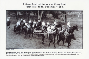 Eltham District Historical Society Inc
Photograph, Eltham District Horse and Pony Club, First Trail Ride, December 1953, Dec 1953
The Pony Club was a dream of Diana Bassett-Smith, which came true, based on the British Horse Society Pony Club formed in 1929; a worldwide organisation. A meeting was called at ‘Lavender Park’, the home of Mrs Mary Grant and her brother George ‘Mel’ Balfour. Invited to the meeting were Baye Skues, Eric Rundle, Ben Taylor, the Barringtons, Smiths, Lou Lewis and Gwen Cascaden. They all supported Diana Bassett-Smith for forming a Pony Club. The first formal meeting was held at ‘Landscape’, which was the home of the Barringtons and the former home of artist Percy Leason. Negotiations with the Lands Department resulted in the club being granted use of the grounds in Eltham Lower Park for a peppercorn rent. Eltham was the 4th Pony Club in Victoria; the other three being Frankston, Templestowe and Western District. Together they formed the Pony Club Association of Victoria at Diana Bassett-Smith’s instigation. This image shows club members attending their first rally held in the summer school holidays, December 1953 L-R: Andrew Donald, Alex Smith, Jenny McMahon, David Bell, Fay Hardess, Chrissy Mclean, Jane Kimber, Barry Hardess, Sue Heseltine, Sue Donald, Helen Rank, Elizabeth Thomas, Margot Donald, Christine Cuscaden, Diana Lewis, Erif Reseigh, Stephen Harris, Diana Bassett-Smith Black and white photographic reprint with names printed on frontalex smith, andrew donald, barry hardess, chrissy mclean, christine cuscaden, david bell, diana bassett-smith, diana lewis, elizabeth thomas, eltham district horse and pony club, erif reseigh, fay hardess, helen rank, jane kimber, jenny mcmahon, margot donald, stephen harris, sue donald, sue heseltine -
 Eltham District Historical Society Inc
Document - Binder, Eltham Justice Precinct, 1969-2020
EDHS_04863 - Binder: Eltham Justice Precinct 1. Courthouse 1. Eltham Courthouse interesting facts 2. Plan and elevation drawings 3. Other courthouse plans and fittings 1880s – Brunswick, Maffra, Dunolly , Sunbury, Landsborough and Wodonga 4. Newspaper articles: i. ELTHAM POLICE COURT. (1892, April 1). Evelyn Observer, and South and East Bourke Record (Vic. : 1882 - 1902), p. 2 (MORNING.). Retrieved July 5, 2022, from http://nla.gov.au/nla.news-article60667022 ii. BREAKING A PUBLICAN'S LEG. (1900, July 13). Evelyn Observer, and South and East Bourke Record (Vic. : 1882 - 1902), p. 2 (MORNING.). Retrieved July 5, 2022, from http://nla.gov.au/nla.news-article60688367 iii. ELTHAM COURT. (1901, March 1). Mercury and Weekly Courier (Vic. : 1878 - 1903), p. 3. Retrieved July 5, 2022, from http://nla.gov.au/nla.news-article58578953 iv. ANNIE CHASES A TINKER. (1902, October 3). Evelyn Observer, and South and East Bourke Record (Vic. : 1882 - 1902), p. 2 (MORNING.). Retrieved July 5, 2022, from http://nla.gov.au/nla.news-article64029968 v. ELTHAM POLICE COURT. (1927, May 6). Advertiser (Hurstbridge, Vic. : 1922 - 1939), p. 4 (AFTERNOON). Retrieved July 5, 2022, from http://nla.gov.au/nla.news-article57754748 vi. ELTHAM POLICE COURT. (1927, May 20). Advertiser (Hurstbridge, Vic. : 1922 - 1939), p. 3 (AFTERNOON). Retrieved July 5, 2022, from http://nla.gov.au/nla.news-article57754814 vii. Eltham Police Court (1931, January 9). Advertiser (Hurstbridge, Vic. : 1922 - 1939), p. 4. Retrieved July 5, 2022, from http://nla.gov.au/nla.news-article56734073 viii. Repairs to Eltham Police Station, The Advertiser (1929, May 24). Advertiser (Hurstbridge, Vic. : 1922 - 1939), p. 2 (AFTERNOON.). Retrieved July 5, 2022, from http://nla.gov.au/nla.news-article57759907 ix. ELTHAM COURT. (1929, August 2). Advertiser (Hurstbridge, Vic. : 1922 - 1939), p. 4 (AFTERNOON.). Retrieved July 5, 2022, from http://nla.gov.au/nla.news-article57760345 x. See also Trove list https://trove.nla.gov.au/list/116634 5. Letter: Shire of Eltham Historical Society to Shire of Eltham, 1 July 1969 regarding potential replacement of Eltham Courthouse and the building’s historical significance and acknowledgement 10 July 1969 6. Letter: Shire of Eltham Historical Society to Law Department, 26 May 1972, re preservation of Eltham Courthouse and potential classification and acknowledgement 7 June 1972 7. Newspaper article: Strangers around, so Eltham sought protection by Marguerite Marshall, Diamond Valley News, Tuesday, April 6, 1982, p2 (On reverse side, Top job for our Pauline, p1) 8. Eltham Courthouse Colour Scheme, Public Works Department, 10 September 1983 9. Newspaper article: Eltham Courthouse under threat of closure by Helen Gillman, Diamond Valley News, October 16, 1984 10. Newspaper article: Courthouse to close by Helen Gillman, Diamond Valley News, Tuesday, November 20, 1984, p1 (also on p2 an article about Diamond Valley Shire festivities for the State’s 150th) 11. We will keep your court – Kennett, Diamond Valley News (probable), c.Dec. 1984 12. Letter: Shire of Eltham to Shire of Eltham Historical Society, 15 March 1985, regarding potential for use of building as a museum and reply dated 17 April 1985 regarding Society’s interest in use of the building 13. Letter: Department of Conservation Forests & Lands to Shire of Eltham, August 1987, regarding expressions of interest in the building and letter from Shire (18 August 1987) to Society advising of same 14. Letter: Department of Conservation Forests & Lands to Shire of Eltham, 30 March 1988, advising Courthouse to be used by Eltham Youth Resources Centre and the rear section by other community groups. Noted that the historical society was suggested by Council as a future user of the adjoining police residence when Council first sought management of the building and that should be investigated. Includes Schedule of Repair and Maintenance Work (4 pages), Existing Conditions Survey 30/7/1987 (6 pages) and 1 page plan view diagram 15. Memo: Historic Places Section to Eltham Youth Resource Centre re paint analysis of Courthouse, 17/5/1988, (6 pages) 16. Newspaper article: Courthouse renovation by Jodie Haythorne, Diamond Valley News, November 23, 1992 17. National Trust of Australia Registration (classified 20 Oct 1977), printed March 2000 18. Letter: Heritage Victoria 28 Feb 2002 regarding the replacement of the Courthouse Stand (Witness Box) 19. Article: There’s still order in this stately court house, Eltham Shire (magazine), date unk., p22-23 20. Eltham Court House, Statement of Significance, Heritage Victoria Register, printed Nov 2004 21. Eltham 1860 Former Court House 730 Main Road Eltham, collated by Eltham District Historical Society Incorporated 2005 (4 pages) 22. Book Extract: Eltham, Historical Court Houses of Victoria by Michael Challinger, Palisade Press, 2001 23. Newspaper article: Courthouse rich with history by Harry Gilham, Nillumbik Mail, c.2001 (see also EDHS_03333) 24. Notes on history of site from Crown Reserve File Rs 12128, Municipal Buildings (Local Community Welfare Reserve) at Eltham, Department of Sustainability and Environment, April 2005 (4 pages) 25. Newspaper article: Historic building upgrade, Diamond Valley Leader, August 3, 2005, p17 26. Newspaper article: Courthouse regeneration secures boost, Valley Weekly, August 10, 2005 with picture of Harry Gilham, Steve Herbert and Greg Johnson 27. Newspaper article: Poets are summonsed, Diamond Valley Leader February 22, 2006, p37 features picture of Helen Lucas at the Eltham Courthouse 28. Newspaper article: Sharing a love of legalities, Diamond Valley Leader, March 1, 2006, p7 features a picture of Rob Hulls and Steve Herbert talking to students in the courthouse 29. Newspaper advertisement: Nillumbik Tender No. 2021-33, Building Restoration Works, Old Eltham Courthouse, The Age, November 7, 2020 30. Form: Police Officer’s Return To A Warrant Of Distress 31. Handwritten notes: three pages listing all 48 of the pigeon hole form listings in the cabinet in the courthouse 2. Police Quarters 1. 1971 Surveyors Plan of 728 Main Road and the Adjoining Courthouse 2. Letter: Shire of Eltham to Shire of Eltham Historical Society, 5 June 1981, requesting the society give consideration to the suitability of the existing buildings (former Vermin and Noxious Weeds Office, Department of Crown Lands and Survey) for historical purposes such as a museum 3. Minutes: Shire of Eltham Historical Society Committee Meeting, 10 June 1981 (2 pages) includes reference to possible use of building as a museum (also reference to Bills Horse trough to be retained) 4. Extract from Victoria Police Gazette 1930 with details of building and site 5. Newspaper article: Cubby haven, Diamond Valley News, October 28, 1991 about replica Police Station with picture of replica along with Monika Roitinger and Garry Bartlett outside the Police Station 6. Environment office up for sale? Mountain Views, Monday, June 12, 1995 (Nillumbik Shire Council proposing to sell property. Did not proceed as ownership held by the State of Victoria) 7. Extract from National Trust February 1998 edition, “Police Rescue” which states Heidelberg and Eltham Police Residences are the oldest known Police Residences in the Melbourne Metropolitan district 8. Newspaper article: The first police office by Harry Gilham, Nillumbik Mail, December 13, 2000 (also photocopy with notations on picture identifying buildings and Harry’s typed draft) 9. Fax Memo: Victoria Police List of Officers in Charge, Eltham Police Station, 1857-1991 onward, 21 Jan 2003 10. Former Police Quarters, Statement of Significance, Heritage Victoria Register, printed Nov 2004 11. Eltham 1860 Former Police Quarters 728 Main Road Eltham, collated by Eltham District Historical Society Incorporated 2005 (5 pages) 12. Report: Eltham District Historical Society to Living and Learning Nillumbik, 14 April 2010 regarding the poor state of condition of the former Police Residence 13. Photocopy of three photos of the former Police Residence, former Police Station (relocated to rear of site) and Stables, October 18, 1991 3. Lockup 1. Newspaper article: Heritage permit bid, Diamond Valley News, January 17, 2001 (also article “Eltham library tops”) includes picture of lockup located in Youth Road 2. Newspaper article: Old lockup in new site, Diamond Valley Leader, March 21, 2001, p15. Includes picture of Harry Gilham with lockup at justice Precinct 3. Letter: Victoria Police to Eltham District Historical Society, 20 March 1991 including laser print photo of lockup in 1963 at 23 Pryor Street 4. Fax: Graham Clark, Associated Crane Trucks Pty Ltd, 833 Main Road Hurstbridge; Quote 26.2.99 for $1,080 to move lockup from Youth Road to 728 Main Road 4. Local History Centre 1. Victoria Government Gazette: Photocopy, No. 165, Tuesday, December 7, 1858, establishment of a Court of Petty Sessions at Eltham, 7 December 1858 2. Victoria Government Gazette: Photocopy, September 16, 1859, contract issued for Police buildings at Eltham to Langridge and Co., McCarter, Baillie, Nicol and Co, Chadley, Amos and Co., Cameron, Payne, £1,150.7.0 3. Victoria Government Gazette: Photocopy, October 2, 1860, contract issued for Court of Petty Sessions at Eltham to James Duncan, £600 4. President’s Report, Eltham District Historical Society, Annual General Meeting, Wednesday, March 11, 1998 – covers the establishment of the Local History Centre and new home for the Society 5. Extract for EDHS Newsletter July 1998 – Eltham Local History Centre – Official Opening 6. Unveiling of 728 Street Sign, Speech notes by Cr Dianne Bullen, December 2000, includes invoice from John Sharp Signs Pty Ltd, 24/10/2000 and planning approval drawing dated 24/3/1999 reproduced in Newsletter No. 135 November 2000 7. Letter: Eltham District Historical Society to Living and Learning Centre, undated draft regarding being a member of the committee reviewing the development of the site 8. Notes from Rod Grant re funding of site development under the Community Jobs Program 9. Letter: Eltham District Historical Society to Nillumbik Living and Learning, 28 October 2004 re inclusion of the Society in enhancing the site under the Community Jobs Program 10. Letter: Department of Sustainability and Environment to Eltham District Historical Society, 28 February 2005 re preparing draft Conservation Plan and copy of cover letter in response 2 April 2005 11. Levels and Layout Plan, Nillumbik Shire Council, September 2005, AO copy 12. Letter: Department of Sustainability and Environment to Eltham District Historical Society, 12 September 2005 re Eltham Justice Precinct Conservation Management Plan 13. Letter: Living and Learning Nillumbik, 2 February 2006 to Eltham District Historical Society re forming a Committee to advise on the use, maintenance, management and preservation of the Justice Precinct 14. Minutes: Meeting of a Task group to explore the establishment of a Committee to manage the Eltham Justice Precinct, 20 December 2005 (with hand written notes) 15. President’s notes (EDHS), General Meeting item, 11 May 2006 pertaining to use and condition of the Eltham Justice Precinct 16. Paint estimates, Old Eltham Court House, undated 17. Notes from meeting 26 September (2006), Eltham Justice Precinct Committee 18. Notes from meeting 27 November (2006), Eltham Justice Precinct Committee 19. Terms of Reference for the Eltham Justice Precinct Committee, Draft for Living and Learning Committee Meeting 24 Jan 2007 (4 pages) 20. Newspaper article: Panel set up, Diamond Valley Leader, 7 March 2007 21. Minutes: Meeting of Eltham Justice Precinct Subcommittee, 10 May 2007 22. Minutes: Meeting of Eltham Justice Precinct Subcommittee, 5 July 2007 23. Minutes: Meeting of Eltham Justice Precinct Subcommittee, 11 October 2007 24. Minutes: Meeting of Eltham Justice Precinct Subcommittee, 7 February 2008 25. Minutes: Meeting of Eltham Justice Precinct Subcommittee, 10 April 2008 26. Minutes: Meeting of Eltham Justice Precinct Subcommittee, 14 August 2008 27. Letter: EDHS (Sue Law) to Living and Learning, 6 September 2008 re proposed signage 28. Agenda: Meeting of Eltham Justice Precinct Subcommittee, 16 October 2008 29. Suggested guidelines for use of the Court House for exhibitions 30. Handwritten note re Ken Eckersal and Uniting Church of possible donation of church organ for sale, proceeds to be used for activities at the Justice precinct 31. One page typed notes on each of the buildings in the Eltham Justice Precinct 5. Miscellaneous 1. Photocopy from Pioneers & Painters (2 pages) covering the establishment of Police and Court of Petty Sessions at Eltham 2. Photocopy of photo looking northeast across Little Eltham buildings c.1910 with notes 3. Photocopy of J.H Clarke photo looking up Maria Street from near Dalton Street with notes identifying precinct buildings 4. Photocopy of photo of Court House and Police Quarters with cow outside from Heather Jenkins scrapbook with notes identifying buildings 5. Sketch and notes with dimensions for blue stone lockup including other miscellaneous handwritten notes 6. Unidentified heritage review details of Justice Precinct (c.2004) 7. Hand written notes of telephone conversation held with Dennis McKay (6 May 1997) re Council use of site 8. Flyer: Victoria Police Historical Unit 9. Photocopy of thumbnail images of various Justice Precincts (not identified) 10. Email correspondence, 4 and 10 January 2008; J. Connor to Council and Councillors pertaining to proposed new toilet facilities at rear of Courthouse annexe. Two ring lever arch binder, white with various photocopies, printouts, newspaper clippingsHG Folders 15/52/59 integratedharry gilham collection, eltham courthouse, eltham justice precinct, eltham police residence, lockup, eltham community festival, eltham festival, eltham, heritage assessment, police residence -
 Marysville & District Historical Society
Flyer (item) - Information Flyer, Department of Conservation, Forests & Lands, Lady Talbot Forest Drive, February 1988
A flyer with information on Lady Talbot Forest Drive and the attractions in the area surrounding it.A flyer with information on Lady Talbot Forest Drive and the attractions in the area surrounding it. Lady Talbot Drive a 24 kilometer scenic rainforest car journey which passes a number of walks and waterfalls in the Yarra Ranges National Park. Lady Talbot Drive is named after Lady Sarah Elizabeth, the wife of Sir Reginald Talbot, who was the Governor of Victoria from 25th April, 1904 to 6th July 1908.7761(F1)lady talbot drive, lady talbot forest drive, marysville state forest, sir reginald talbot, lady sarah elizabeth talbot, wishing well, taggerty river, phantom falls, keppel falls, beeches walking track, marysville, mount sugarloaf, logging, victoria, walking tracks -
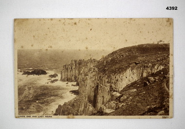 Bendigo Military Museum
Postcard - SOUVENIR POSTCARD, C.1950
Postcard sent to F.G.Davey by Alan Fi on 26th September 1950. Part of the Frederick Gardner Davey DFC RAAF collection. refer Cat No 3536P for his service details.Postcard, rectangular featuring a sepia toned photograph of coastal cliffs and ocean, photo has a white border which contains a caption on the bottom LH section, on the rear in black type are details of the postcards manufacture, a British orange 2d stamp is attached to the top RH corner which contains King GeorgeV1On rear top L H corner, “Triangular Lands End stamp” in purple, over the stamp is a postage franking mark, “Penzance Cornwall, 3 pm, 26 Sept 1950”. Hand written in blue ink is, “A note to F.G.Davey from Alan Fi” , then “F.G.DAVEY Esq, Olinda Steet Bendigo Victoria Australia”postcard, souvenir, letters