Showing 40539 items matching "roads and streets"
-
 Whitehorse Historical Society Inc.
Document, Villa Residence, 11/12/1937 12:00:00 AM
Auction brochure for 'beautiful modern brick villa residence', with 4 1/4 acres of land, Mitcham Road Mitcham, Saturday December 11 1937.Auction brochure for 'beautiful modern brick villa residence', with 4 1/4 acres of land, Mitcham Road Mitcham, Saturday December 11 1937, under instructions from the executors of the estate of the late E. E. Walker. Frontages to Mitcham Road, Delhi Street and Agra Street. Auctioneers: Baillieu Allard in conjunction with Drake & Co. Original copy framed, located in Map Drawer.Auction brochure for 'beautiful modern brick villa residence', with 4 1/4 acres of land, Mitcham Road Mitcham, Saturday December 11 1937.walker, edgar edwardes, walker estate, mitcham road, mitcham, delhi street mitcham, agra street, mitcham, drake & co., baillieu allard pty ltd -
Whitehorse Historical Society Inc.
Letter - Correspondence, McGlone land, 2/12/1921 12:00:00 AM
Letter from T.R.B. Morton & Son to W.J. McGlone.Letter from T.R.B. Morton & Son to W.J. McGlone about terms for a possible sale of land the the corner of Whitehorse Road and Elizabeth Street, Mitcham, 2 Dec 1921.Letter from T.R.B. Morton & Son to W.J. McGlone.mcglone, william j., t.r.b. morton & son, whitehorse road, mitcham, elizabeth street, mitcham -
 Ringwood and District Historical Society
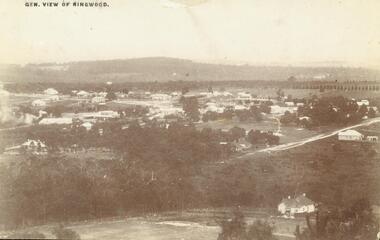
Photograph, View of Ringwood in 1912 taken from Loughnan's Hill
Black and white photograph looking across valley with small settlement. Mountains in background. (2 postcard copies and 2 enlargements). House in right foreground is in what is known now as Wildwood Grove. The dirt track above is Ringwood St. Field above is the football field with diagonal track coming out at Melbourne Street, later Eastland shopping complex. House on left is in Adelaide Street. Warrandyte Road is above it."Typed on back of one enlargement, "Copied from a postcard mailed in Ringwood, 1912, copied 1959. House in right foreground is in what is known now as Wildwood Grove. The dirt track above is Ringwood St. Field above is the present football field with diagonal track coming out at Melbourne Street. House on left is in Adelaide Street. Warrandyte Road is above it." House bottom RH side was still there in 1970 in Wildwood Grove (off Ringwood St). Ringwood Street lower centre to RH side. Field above Ringwood Street is the football field with diag. walk coming out at Melbourne Street. House on LH side in Adelaide Street. Warrandyte above it. Steam at LH from Bently's Steam Joinery at corner Main Street and Warrandyte Road. -
 Chelsea & District Historical Society Inc
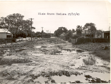
Photograph - Elsie Grove, Chelsea, 1949
This photo is one of a collection of photos taken during Alan Niemann's - Drainage-Road Making Scheme. Elsie Grove runs between Station Street and Randal Avenue, Chelsea.Black and white photo looking east along Elsie Grove, Chelsea. The road is unmade and rutted with large puddles, houses line both sides and electricity poles are on the left side of the road. The photo has been taken from Station Street.unmade street, aspendale, alan niemann, drainage-road making scheme, elsie grove -
 City of Kingston
Pamphlet - Colour, Roy Dunn Pty. Ltd, Subdivisional auction of Highett Station Estate, c.1924
Sales plan for land in the suburb of Highett, bounded by Worthing Road, and the Melbourne to Frankston Electric Railway Line, including LePage Street. The developing urban area of Highett within the City of Kingston. This land sale pamphlet illustrates the subdivision of land within the municipality and the changing demographic of the district as new houses are constructed close to infrastructure.Colour pamphlet advertising a subdivisional auction of the Highett Station Estate. Incorporates a map of the estate bordered by Worthing Road and the Melbourne to Frankston Electric Railway, and including LePage Street. Handwritten in black ink on front cover: Late LePage / Wickham Rdland sales, estate, highett -
 Marysville & District Historical Society
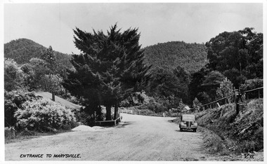
Postcard (item) - Black and white postcard, Valentine Publishing Co. Pty. Ltd, Entrance to Marysville V.11, 1923-1963
A digital copy of an early black and white photograph of the Marysville-Wood's Point Road at the corner with Murchison Street in Marysville in Victoria.A digital copy of an early black and white photograph of the Marysville-Wood's Point Road at the corner with Murchison Street in Marysville in Victoria. This postcard was published by the Valentine Publishing Co. Pty. Ltd. as a souvenir of Marysville.marysville, victoria, postcard, valentine publishing co, souvenir, murchison street, marysville-wood's point road -
 Bacchus Marsh & District Historical Society
Map, Main Road and Gell Street Allotments
This map shows allotments of land along Gell Street Bacchus Marsh running between Main Road (now called Main Street) and Lerderderg Street. The total area of the map encompasses Main Road, Church Street, Lerderderg Street and Gell Street. 36 allotments of land are shown. Three allotments which connect to Main Road are shaded in pink. The date of the map has not been established but the National Bank building erected in 1865 near the Border Inn is indicated which indicates that the map dates from after 1865. Reports in the Bacchus Marsh Express newspaper on 5 March 1870, page 2, column 6 announced building lots in Gell Street had been withdrawn from sale by the agent J.E. Crook. Later reports in the Express on 1 November 1873, page 2, column 2 advertised 14 allotments of land in Gell Street for sale. Single page map showing allotments of land along the Main Road (Main Street) and Gell Street areas of Bacchus Marsh. Part of a set of maps which are pasted into a bound volume containing 76 maps or plans in total. High resolution digital image stored on BMDHS computer network. bacchus marsh victoria maps, gell street land allotments, main street land allotments -
 Ballarat Heritage Services
Photograph - Photograph - Colour, Clare Gervasoni, Former Yandoit Hills School 2052 after being moved to Hepburn Springs, c2005, c2005
This building was moved from Yandoit Creek to the corner of Main Road and Seventh Street, Hepburn Springs. Colour photograph of on old schoolhouse that was moved from Yandoit Hills to the corner of Main Road and Seventh Street, Hepburn Springs. The building was used for religious services before being turned into a private residence. yandoit hills state school no 2052, education, hepburn springs, yandoit hills, yandoit creek -
 Ringwood and District Historical Society
Pamphlet, Subdivisional Auction Sale, Bedford Park, Ringwood - 1924
Bedford Park subdivisional development did not eventuate. The land adjoining the railway line became parkland with provision for sporting facilities and the remainder was purchased by the Education Department as the site for Ringwood High School/Secondary College. Double sided bifolded auction sale advertisement including subdivision features and local facilitiesSubdivision plan includes Bedford Road, Graham Road, Joyce Street, Anderson Street, and Adams Street -
Whitehorse Historical Society Inc.
Map, Applied for the Roman Catholic Church, 1848
Photocopy of manuscript map inscribed 'Reserve 40 Parish of Nunawading'.Photocopy of manuscript map inscribed 'Reserve 40 Parish of Nunawading'. Streets not named. Note on verso: Site reserved for Roman Catholic Church in Nunawading c1848 (Cr Riversdale and Warrigal Roads)Photocopy of manuscript map inscribed 'Reserve 40 Parish of Nunawading'. churches, catholic church, riversdale road, surrey hills, warrigal road, surrey hills -
 Kew Historical Society Inc
Photograph - Street Works, Studley Park Road, March 1934
Studley Park Road, like most streets in Kew, was originally a dirt road. Street works during the Great Depression included bituminising major roads in the district. This photograph of Council works originated in the City of Kew Engineers Department as a record of works undertaken. It was given to the collection by a Mrs Fisher in 1998.Well provenanced photograph of Council-funded public works in Kew during the Great Depression. Original sepia photographic positive of Studley Park Road, Kew while resurfacing of the street was taking place. The Kew Junction is just visible in the distance. Boys sitting on a drum at right. Behind them is the brick fence and front entrance to Tara Hall.Typed reverse: "B4 / Kew C.C. / Studley Park Road showing drag spread surfacing with premixed material, unrolled material on the right, March 1934"roadworks -- kew (vic.), street works -- kew (vic.), public works kew (vic.), studley park road -- kew (vic.), city of kew -- engineers department, city of kew -- public works -- great depression -- 1930s -
Whitehorse Historical Society Inc.
Document, Walker Estate Mitcham, 8/10/1938 12:00:00 AM
Auction brochure for 'Beautiful brick residence' of 9 rooms, with 1 1/2 acres of grounds, subdivided into 12 sites for brick residences, Saturday 8th October 1938.Auction brochure for 'Beautiful brick residence' of 9 rooms, with 1 1/2 acres of grounds, subdivided into 12 sites for brick residences, Saturday 8th October 1938, by order of the Executors of the late E. E. Walker. Frontages to Mitcham Road, Agra Street, Simla Street and Meerut Street. Auctioneers: Edward Haughton Pty Ltd and Drake & Co. Original copy framed, located in Map Drawer.Auction brochure for 'Beautiful brick residence' of 9 rooms, with 1 1/2 acres of grounds, subdivided into 12 sites for brick residences, Saturday 8th October 1938.walker, edgar edwardes, walker estate, mitcham road, mitcham, agra street mitcham, simla street mitcham, meerut street mitcham, drake & co., edward haughton pty ltd -
 Surrey Hills Historical Society Collection
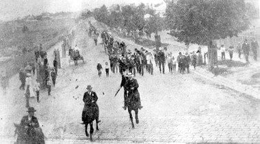
Photograph, Parade in celebration of King Edward VII's birthday, 1902, 1902
The parade was held in celebration of King Edward VII's birthday on 4 July 1902. This was the first public appearance of the German Band formed on 30 May 1902. The leading horseman is Mr Rowland Coe. He is followed by Mr George Robinson, a butcher of Canterbury Road. The man in the white hat is Mr Sam Kellett, businessman of Erasmus Street. Behind him on foot and partly obscured is Mr Alexander McNeill of the Surrey Family Hotel. Band master is Harry Pollard, painter and paper-hanger, and next to him is Constable Hill. The small boy in the sailor suit is Perc Venman of Essex Road and in the buggy near the footpath is Mr and Mrs William Maling. Information came from David Staig senior. Further research: William Saunders Maling, a son of John Butler Maling, was a builder who lived at 17 Balwyn Road, Canterbury. Rowland Coe, a butcher and son of James and Elizabeth Coe of Sunbury Crescent enlisted in AIF in WW1. He later lived at 233 Elgar Road, Box Hill. William Percival Reginald (Perc) Venman was born in Surrey Hills in 1894; he died in Surrey Hills in 1951 and lived at 27 Essex Street for much of his life. He and his wife are buried in Box Hill Cemetery. The identity of Sam Kellett of Erasmus Street is questioned. Edward Kellett built 'Yielma' in Erasmus Street but was deceased by 1902. He had 3 sons: Edward Allan (1854-1932); George Henry (1858-1921) and William John (1865-1945).Black and white photo of a number of men on horses leading a parade down Station Street (Windsor Crescent) to Union Road. Street trees on the RHS are mature whilst the ones on the LHS look to be newly planted. They have wooden guards around them. The area to the left is blurry but would be the railway line and station surrounds. Roads are well formed with bluestone channels.parades and processions, bands, german band, windsor crescent, william saunders maling, mrs hannah maling, miss hannah miller, constable hill, perc venman, george robinson, sam kellett, alexander mcneill, rowland coe, harry pollard, william percival reginald venman -
Canterbury History Group
Photograph - Garden of "Roquebrune" corner of Canterbury Road and Gascoyne Street Canterbury, c1920
"Roquebrune" built in 1912 or 1914 by G.H.Tarrrant and demolished in 1971 to make way for the Baptist Nursing Home on the corner of Canterbury Road and Gascoyne Street Canterbury. Now apartmentsGarden and side of the house "Roquebrune" built in 1912 or 1914 by G.H.Tarrrant and demolished in 1971 to make way for the Baptist Nursing Home on the corner of Canterbury Road and Gascoyne Street Canterbury. Now apartmentscanterbury, canterbury road, gascoyne street, roquebrune, edwardian style, baptist nursing home, aged people, nursing homes, garden -
 City of Kingston
Pamphlet - Colour, R. Malcolm Estate Agents et al, Last Chance Land Sale Heritage Estate Cheltenham, c.1994
Sales plan for land in the suburb of Cheltenham, bounded by Chesterville Road and Bernard Street, and incorporating Clendon Court, Tintern Grove and Tintern MewsThis land sale pamphlet illustrates one of the last subdivisions of the century in Cheltenham, incorporating house and land packages. It shows that land sales and subdivision for the area had slowed considerably by the end of the 1900s and that the infrastructure was significantly developed. Colour pamphlet advertising last chance land sale of Heritage Estate Cheltenham. Incorporates a map of the estate bordered by Chesterville Road and Bernard Street, and including Clenton Court, Tintern Grove and Tintern Mews.cheltenham, land sales, estate -
 Ringwood and District Historical Society
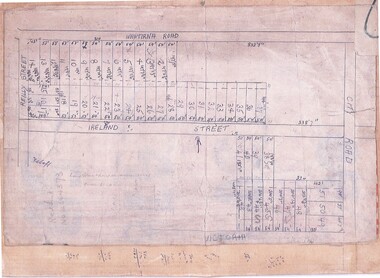
Document, Subdivision Map (Undated) - Ringwood, Victoria
Hand-drawn copy of subdivision plan showing numbered residential allotments with property dimensions.Map includes Wantirna Road, Ireland Street, City Road and Victoria Street (later Regina Street), Ringwood, Victoria. -
 Hume City Civic Collection
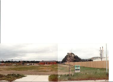
Photograph, early 1990s
The series of 5 photographs feature different views of the Woodlands housing development which opened up land bounded by Gap and Anderson Roads, Cornish Street and Elizabeth Drive in the early 1990s. It was a large housing development built close to Sunbury township.A view of the northern boundary of the Woodlands housing development in Anderson Road. A paling fence divides the estate from the 'Malley' factory, now 'Storage King' which is on the corner of Cornish Street and Anderson Road. A 'For Sale' sign is in the foreground and a partly built house is in the middle distance.housing developments, anderson road, george evans collection -
Whitehorse Historical Society Inc.
Letter - Correspondence, Crabhole Hill, 2016
An email from Ted Arrowsmith querying the name Crabhole Hill, Mitcham.An email from Ted Arrowsmith querying the name Crabhole Hill, Mitcham, which encompasses Whitehorse Road from McDowall Street to Thomas Street as reported in the Whitehorse Historical Society Newsletter, series 24 No.3 May - Jun 2016 from a transcript from the Blackburn & Mitcham Reporter 17 Jun 1932.An email from Ted Arrowsmith querying the name Crabhole Hill, Mitcham. crabhole hill, mitcham, arrowsmith, ted, mcdowall street, mitcham, thomas street, mitcham, whitehorse road, mitcham, blackburn & mitcham reporter, whitehorse historical society inc -
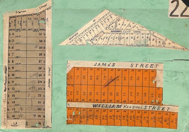 Ringwood and District Historical Society
Card, Subdivision Maps - Ringwood, Victoria - (Undated, circa 1920s)
Collage of three residential allotment maps on green cardboard backing.Subdivisions include West Prussia Road, Wantirna Road, Station Street, James Street, Bedford Road, Williams Grove (later Lena Grove), and William Street (later Kendall Street), Ringwood. -
 Ringwood and District Historical Society
Flyer, Executor's Auction Subdivision Advertisement, Lilydale Road and Oban Road, Ringwood East, Vic. - 1937
Single page advertisement for Executor's Auction of land in Ringwood East on Saturday, May 29, 1937 with locality map showing 26 building sites for auction highlighted in brown, and brief summary of local services available. Subdivision includes Old Lilydale Road, Joseph Street, Dynes Street, Albert Street (later Wyrunga Street), Carcoola Road, and Mount Dandeong Road. (Carcoola Road incorrectly shown as Oban Road on the subdivision plan). Auctioneer - C.E. Carter, (Phone Ringwood 24. -
 Kew Historical Society Inc
Plan, Survey Plan, Park Hill Road, Kew, 1880-1890
The streets identified on the survey plan - Cotham Road, Park Hill Road East, Park Hill Road West in Kew were each gazetted by the Victorian Government in 1865. The hand-coloured survey plan was completed by Holland Loxton, Town Clerk and Surveyor of the Borough of Kew from 1866. The unnamed survey plan includes names of land owners in addition to measurements (2 chains to 1 inch) and streets. Named owners include Webster, Payne and Francom which will enable us to narrow down the creation date of the survey.Handdrawn survey plan by a former surveyor and town clerk of KewHand drawn and coloured survey plan created by Holland Loxton, Surveyor and Town Clerk of Kew, showing land owned by Payne in Park Hill Road, Kew. The plan includes street names, land measurements and land owners.surveys - kew, maps - kew, holland loxton, park hill road - kew, holland loxton -- surveyor, survey plans -- parkhill road -- kew (vic.) -
Whitehorse Historical Society Inc.
Map, Municipality of Nunawading, c1950
Plan No 234, compiled and photo-lithographed at the Melbourne and Metropolitan Board of Works under the direction of G.R. McGowan, Chief Surveyor.Plan No 234, compiled and photo-lithographed at the Melbourne and Metropolitan Board of Works under the direction of G.R. McGowan, Chief Surveyor. Covers the area each Side of Canterbury Road from Orchard Grove to Vernon Street. Includes detail of creeks.Plan No 234, compiled and photo-lithographed at the Melbourne and Metropolitan Board of Works under the direction of G.R. McGowan, Chief Surveyor. blackburn south, gardiners creek, blackburn, blackburn creeklands -
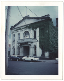 Kew Historical Society Inc
Photograph - Former Kew Town Hall, Walpole Street, 1972
The Municipality of Kew was granted independence in 1860. It was declared a borough in 1863, a town in 1910 and a city in 1921. In 1994, Kew was amalgamated into the new City of Boroondara. In 1960, a new Town Hall in Cotham Road was opened. The Municipal Offices that had remained in the former Town Hall in Walpole Street until it was moved to the new Civic Centre on the corner of Cotham Road and Charles Street in 1972.This is a rare and important colour photograph of the Kew Municipal Offices (former Town Hall) taken on 11/2/1972 in the year that the building was demolished and replaced by a Safeway Supermarket.Colour photographic positive (polaroid) of the front of the (former) Kew Town Hall in Walpole Street between High Street and Malmsbury Street, on the west side where Woolworth's supermarket now stands. The photograph, taken in February 1972, shows the detailing of the Italianate rendered-brick facade, added in the 1880s when the hall was renovated. The earliest building on the site was the Kew Athenaeum Hall (built 1860) which was purchased by Kew Council in 1865. The Town Hall was sold to Woolworth's and subsequently demolished in 1972 when the civic offices were transferred to a new building on the corner of Charles Street and Cotham Road.kew town hall -- walpole street, local government -- kew, town halls -- melbourne (vic.) -
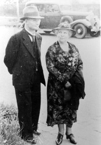 Surrey Hills Historical Society Collection
Photograph, Joe and Emily George of Scheele Street, Surrey Hills
Mrs Emily Ruth George of 26 Scheele Street, with husband, Joe. Emily & Joe were English migrants; they bought their home in 1919. Daughter Marie was born in 1914 when they are listed in the electoral roll at 'Hasland', Croydon Road, Surrey Hills; his occupation is given as a boilermaker. Emily (nee Sturgess) - d 15 November, 1960; buried Box Hill Cemetery - M-199A-0034 along with daughter Marie. Possible birth c Oct 1880, Birmingham (not confirmed); marriage c Jan 1905, Chesterfield, Derbyshire. Marie George became a school teacher and was on the staff at Chatham Primary School for a number of years. She died in February 1989. Mrs George was known for her hospitality. Anecdotes: On one occasion the government was to build six houses opposite in an area which was mostly paddocks. The materials were delivered and a caretaker allocated to guard them. He arrived with his wife to find a meagre tin shed as ‘home’. Mrs George responded by boarding the couple, for a very minimum amount for the six months. A rather different anecdote involves the droving of sheep from Lower Plenty across paddocks and tracks, through Doncaster and down Union Road to the station en route to the Richmond abattoirs. This was a seasonal activity and the men (and sheep) used to rest in the paddocks in Union Road, at the corner of Weybridge Street – behind the Georges’ home. When Mrs George heard the sheep, she would go out and fill the drovers’ billies with tea, handing out thick cheese sandwiches made from her homemade bread. A black and white photograph of a man and a lady dressed to go out and standing in the street. There is a car parked on the other side of the road in the background.(mrs) emily george, (mr) joe george, scheele street, surrey hills, mont albert, droving, clothing and dress, (miss) marie george, 'hasland', croydon road, (mrs) emily ruth george, (miss) emily ruth sturgess, box hill cemetery -
 Bendigo Historical Society Inc.
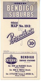
Map - Three Road Maps of Bendigo, 1962
George Robert Broadbent (1863-1947), cyclist and map publisher, was born on 3 November 1863 at Ashby near Geelong, Victoria, son of George Adam Broadbent, Lancashire-born draper, and his wife Elizabeth, née Ruffhead. When the family moved to North Melbourne Broadbent attended the Errol Street school, followed his father's trade, and became an early cycling and cycle-racing enthusiast. At various times Broadbent held most Victorian and Australian road records, and two of his performances on solid tyres—203 miles (327 km) in 24 hours on a penny farthing, and 100 miles (161 km) in 6 hours 20 minutes on a 'safety' bicycle—were never bettered. He established records for all distances between 130 and 220 miles (209 and 354 km), and for all times between 8 and 12 hours, at the Exhibition Grounds track in May 1894, and road records for 50 and 100 miles (80 and 161 km) in October 1896. The Australian Cyclist acknowledged him 'the finest road rider that Australia has ever produced'. A foundation councillor of the League of Victorian Wheelmen in October 1893, Broadbent contested the first Warrnambool-Melbourne race in 1895, and was active in the Good Roads Movement. Next year he issued a road map of Victoria, 'prepared … after some sixteen years riding and touring in all parts of the Colony', which indicated general topography, distances, and roads classified as 'good', 'fair' or 'ridden with difficulty'. It was to become Victoria's standard map, and the basis of a continuous publishing programme by Broadbent's Official Road Guides Co.Three Road Maps of Bendigo, Bendigo and Suburbs, Bendigo and Eaglehawk. Two fold out maps printed in colour and produced by Broadbent's Road Maps Pty. Ltd. 475 Collins Street Melbourne. One map printed by Bolton's Bendigo.history, bolton's, bendio broadbent maps -
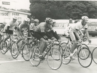 Lakes Entrance Historical Society
Photograph - Gippsland Games Senior Criterium, Lakes Post Newspaper, 1/03/1995 12:00:00 AM
road cyclists taking part in the Gippsland Games Senior Criterium event sponsored by Lakes Entrance RSL showing cyclists passing Sunnyside Park Myers Street Lakes Entrance VictoriaBlack and white photograph of road cyclists taking part in the Gippsland Games Senior Criterium event sponsorded by Lakes Entrance RSL showing cyclists passing Sunnyside Park Myers Street Lakes Entrance Victoriasports, cycling, recreation -
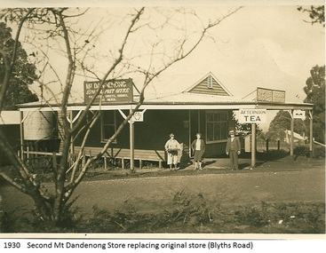 Mt Dandenong & District Historical Society Inc.
Photograph, Mt Dandenong Store, 1930
Image shows the Mt Dandenong Store and Post Office that replaced the former Post office and Store that was located on the corner of Old Coach and Farndons Roads. The store relocated following the opening of the new Main Road in 1926. The store pictured was on the corner of Helen Street and the Main Road. The image was taken in 1930. The photograph was taken by a member of the Dower family.Donated as a jpeg digital image that shows the Mt Dandenong Store on the corner of Helen Street and the Main Road in 1930. Two women and a man are standing at the front. Signs advertising the Store & Post Office, Age and Argus are clearly visible on top of the verandah.Front of image: 1930 Second Mt Dandenong Store replacing original store (Blyths Road)mt dandenong, post office, store, mt dandenong store, main road -
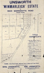 Ringwood and District Historical Society
Flyer, Land Sale Advertisement - Unsworth Winmarleigh Estate, Ringwood, Victoria - circa 1912
Advertisement and attachment for subdivision of land adjoining Warrandyte Road coach route in North Ringwood, with map showing layout of subdivision, summary of local features and services, and terms of sale. Subdivision includes Wonga Road (later Loughnan Road & Warrandyte Road), Unsworth Road, Through Road, Cross Street, and John Street. Contacts - Mrs Unsworth on the Estate or W.M. Unsworth, 58 Little Latrobe Street, Melbourne, Telephone Central 7207. -
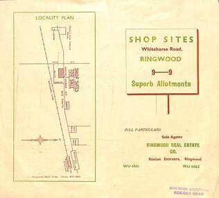 Ringwood and District Historical Society
Flyer, Ringwood Mail, Retail Subdivision Brochure - Plan of New Shop Sites, Ringwood, Victoria. - circa 1950
Double sided folded page advertising shop sites in Whitehorse Road, Ringwood, with locality plan, price list, terms of sale, summary of local facilities and services, and diagram showing layout of 9 retail allotments for sale. These sites were originally zoned as residential as part of the 1926 "Olive Grove Estate" subdivision. (See Vicorian Collections Reference 5169). The 9 new shops were later allocated street numbers 58 to 64 Whitehorse Road, Ringwood.Locality plan showing shop sites for sale on Whitehorse Road, Ringwood, between New Street and Olive Grove. Sole Agents: Ringwood Real Estate Co., Station Entrance, Ringwood, (Telephone) WU6661, WU6662. -
Port Melbourne Historical & Preservation Society
Plan - Traffic census, Port Melbourne, 6 Mar 1947
Traffic census 6th March 1947 showing intersections at Ingles Street and Williamstown Road (no 84), Lorimer Street and Salmon Street )no 90) Beach Street and Bay Street (no 113) Williamstown Road and Beach Road (no 112), Railway Crossing Graham Street (no 77)engineering - roads streets lanes and footpaths