Showing 214 items matching "route 16"
-
 Melbourne Tram Museum
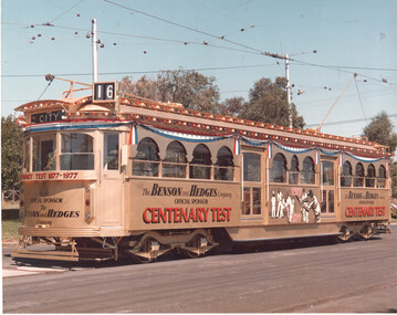
Photograph - Centenary test tram - W7 1024, March 1977
... Colour print of W7 class tram 1024 (City Route 16...Colour print of W7 class tram 1024 (City Route 16 ...Colour print of W7 class tram 1024 (City Route 16) in an all-over advertising livery for the Centenary Test 1977 sponsored by Benson & Hedges as the official sponsor. The reference gives the month of March 1977 as the operation of the tram in the livery. Done before cigarette sponsoring of major sports events was banned,Yields information decoration of tram 1024 for the 1977 Centenary test.Colour print with a number on the rear.In ink "4"tramways, w7 class, tram 1024, cricket, decorated trams -
 Melbourne Tram Museum
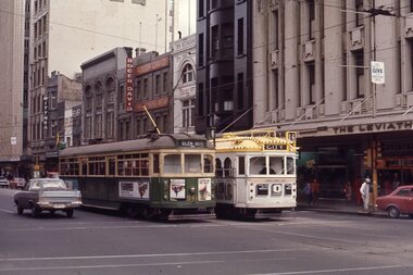
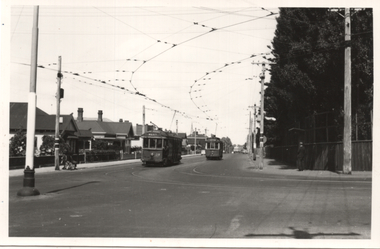
Slide - W6 941 and W7 1024 Swanston St, Ron Hood, 9/1971
... 1024 (City, route 16) in all-over advertising livery... 1024 (City, route 16) in all-over advertising livery ...Photograph of W6 class tram 941 (Glen Iris, route 6) and W7 1024 (City, route 16) in all-over advertising livery for Channel 0 in Swanston St at Collins St. In the background are Wittner shoes, Roger David men's wear, Elmer house, and The Leviathian store. Photo by Ron Hood Sept.1971.Yields information about tram services in Swanston St and all over advertising tram 1024.Colour slide in a plain cardboard mount.in ink "Collins St, Sept 1971, Melbourne, I had just left New Zealand"tramways, swanston st, w6 class, tram 941, decorated trams, w7 class, tram 1024, channel 0 -
 Melbourne Tram Museum
Newspaper, The Age, “Back Home – From Melbourne”, 7/12/1979 12:00:00 AM
... displays tram 294 with route 16 St Kilda Beach... with route 16 St Kilda Beach “Back Home – From Melbourne” Newspaper ...Newspaper clipping titled: “Back Home – From Melbourne” Newspaper clipping from the Age 7/12/79 Tram No 294 Restoration, 50th anniversary for Glenelg tramway Melbourne tram number 294 is back home, in Adelaide, where it was built at Holden body works in Morphettville in 1924. Ran in Melbourne until 1969 then put into storage. Taken to Morphettville for restoration and will feature in celebrations marking 50th anniversary of Glenelg tramway. Photo displays tram 294 with route 16 St Kilda Beachtrams, tramways, restoration, glenelg, 50th anniversary, holden, adelaide, morphettville, aetm, tram 294 -
 Melbourne Tram Museum
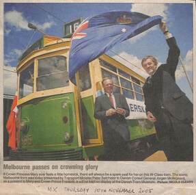
Newspaper, MX Newspaper, Andrew Fyfe, The Age, "Melbourne passes on crowning glory", "For Denmark's little prince, a rattle, a bell and an tram", Nov. 2005
... track in the snow, showing route 16. Photo from Associated... on the Danish Tramway Museum track in the snow, showing route 16. Photo ...Set of newspaper clipping featuring tram 965: .1 - titled "Melbourne passes on crowning glory" being handed over by the Minister for Transport Peter Batchelor to the Danish Consol General Jorgen Mollegaard. From the MX Newspaper, 10/11/2005. .2 - cartoon - undated, from the Herald Sun by Andrew Fyfe about the event and the Royal couple holding a baby. .3 - clipping from The Age, 21/2/2006 of W6 965 running on the Danish Tramway Museum track in the snow, showing route 16. Photo from Associated Press.trams, tramways, denmark, tram museum, restoration, cartoons, minister for transport, w6 class, tram 965 -
 Melbourne Tram Museum
Album - Robert Thomson Slide Collection, "Melbourne 14/9/91 to 21/9/91 16.11.1997 to 23.11.1997"
... " - route 69 & tram 905 - "St Kilda Beach" - route 16 RT230 1997..." - route 69 & tram 905 - "St Kilda Beach" - route 16 RT230 1997 ...Photo - see pdf file for further information. Number Brief Description RT229 1997, Carlisle St, tram 129 - "Kew - Cotham Rd" - route 69 & tram 905 - "St Kilda Beach" - route 16 RT230 1997, Dandenong Rd, tram 86 - "Melbourne" - route 69 RT231 1997, Victoria Pde, tram 856 - "City Circle" - route 00 RT232 1997, Spring St, tram 909 - "City Circle" - route 00 RT233 1997, Swanston St, tram 982 - "University" - route 72 RT234 1997, Swanston St, tram 949 - "Glen Iris" - route 6 & tram 852 - "St Kilda Beach" - route 16 RT235 1997, Swanston St, tram 845 - "University" - route 16 RT236 1997, Swanston St, tram 951 - "?" - route 8 RT237 1997, Flinders St, tram 925 - "City Circle" - route 00 7 tram 2034 - "City La Trobe St" RT238 1997, Tram Defect, tram 98 RT239 1997, Flinders St Station, tram 785 - "?" - route 8 RT240 1997, Flinders St Station, tram 211 - "Moreland" - route ? RT241 Bourke St, tram 2059 - "City Spencer St"- route 87 RT242 St Georges Rd Preston, tram 1003 - "Preston" via St Georges Rd"- route 9 RT243 West Preston Terminus - tram 943 - "St Kilda Beach" - route 10 RT244 Princes Bridge , tram 950 - "City" - route 72 RT245 1997 Port Melb Ter, tram 265 - "Mont Albert" - route 109 RT246 1997 Port Melb Terminus RT247 1997 Port Melb Terminus, tram 285 - "Mont Albert" - route 109 RT248 North Balwyn Terminus, tram 244 - "City Lonsdale St" - route 48 RT249 1997 Bourke St mall, tram 2127 - "Bundoora RMIT" - route 86 RT250 1997 Bourke St mall, tram 2028 - "St Kilda Beach" - route 96 RT251 1997 Batman Ave, tram 239 - "Princes Bridge" - route 70 RT252 1997 Batman Ave Ter, tram 233 - "Wattle Park" - route 70 RT253 Princes Bridge , tram 960 - "City" - route 64 RT254 Swanston St at Flinders St, tram 776 - "Glen Iris" - route 6 & tram 809 - "Toorak" - route 8 RT255 Swanston St at Bourke St, tram 978 - "City" - route 64 RT256 Bourke St at Swanston St, tram 112 - "City" - route 86 RT257 South Melbourne Beach terminus, tram 818, - "East Coburg" - route 1 RT258 Carlisle St, tram 925 - "Kew Cotham Rd" - route 69 RT259 Acland St Terminus, tram 2018 - "East Brunswick" - route 98 RT260 St Kilda Rd Princes Bridge, "St Kilda Beach" - route 15 RT261 Batman Avenue Terminus, tram 24 "Special" & tram 22 - "Wattle park Elgar Rd" - route 70 RT262 Acland St Terminus, tram 646 - "City" - route 16 RT263 Bundoora Terminus - tram 2023 - "Bundoora" - route 86 Demonstrates the work of Robert Thomson in photography, collection and/or production of slidesAssembled album in a black presentation folder of 35 colour slides, collected or produced by Robert Thomson. All photographs have been scanned and placed on the Museum's G drive. A list of all photographs with details has been compiled. melbourne, tramways, trams -
 Melbourne Tram Museum
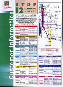
Poster, Swanston Trams, "Swanston Trams - Stop 12 Flinders Street", 1999
... " - giving frequency information for routes 3, 16, 1, 5, 64, 6, 67... frequency information for routes 3, 16, 1, 5, 64, 6, 67, 72 and 8 ...Poster - "Swanston Trams - Stop 12 Flinders Street" - giving frequency information for routes 3, 16, 1, 5, 64, 6, 67, 72 and 8 - all the Swanston St routes. Has a map insert showing these routes and interchanges with rail lines. Gives The Met information centre contact details, along with Swanston's website. Understood this was a proposal, but not actually used. Demonstrates timetable information board layouts - not actually used.Special size sheet printed in full colour and laminated.tramways, swanston trams, timetables, poster, stop information, signs, swanston st -
 Ballarat Tramway Museum
Photograph - Geelong - Aberdeen and Pakington Streets, Keith Kings, 17/12/1955
... " to turn to West route; and No. 16 to Chilwell. Note the trolley..." to turn to West route; and No. 16 to Chilwell. Note the trolley ...Photograph shows the intersection of Aberdeen St (looking east) at Pakington St Geelong with No. 38 running "bang road" to turn to West route; and No. 16 to Chilwell. Note the trolley wire arrangement. Photo by Keith Kings, 17/12/1955, Photo No. Q(m)(6)Yields information about the intersection of Aberdeen and Pakington Streets Geelong and tram operations.Black and White photograph with photographers notes on the rear.See Contexttrams, tramways, geelong, aberdeen st, chilwell, west, tram 38, tram 16 -
 Ballarat Tramway Museum
Model - Model Melbourne SW5 tram and presentation case, Cooee Concepts Pty Ltd, 2008
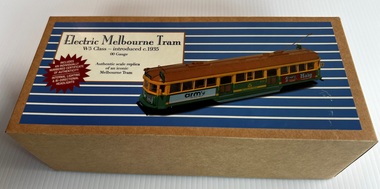
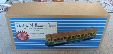
... Kilda, showing route 16. Headlights function in the direction... route 16. Headlights function in the direction of travel ...Detailed in The Met colour scheme of the 1980s with the logo of the early 1980s. Demonstrates an operable model of a Melbourne SW5 class tram.Model of Melbourne Melbourne tram W5 (actually an SW5) No. 812, electric model, made by Cooee Concepts Pty Ltd in China. The model is packaged in a wooden packing case with a blue felt base, contained within a cardboard outer case. The cardboard cover or case has a printed sheet giving details of the model and the history of the W5 Class tramcar. The wooden case has a brass plate detailing the contents. Scale 00 or 1:76. Model made from plastic and metal, with operable lights and motors with operable trolley poles, swiveling bogies, the destination of St Kilda, showing route 16. Headlights function in the direction of travel. The package has a manufacturing date of 2008 printed on it. Contains a plastic cover strip, a plastic holder for the tram, a plastic lift-out strip, a printed Certificate of Authenticity, No. 553 of 700, and a folded sheet giving instructions for the use of the tram on a model tramway - up to 15V DC.models, the met, tramcars, w5 class, sw5 class, tram 812, cooee, cooee collectables -
 Melbourne Tram Museum
Leisure object - Model tram and presentation case, Cooee Concepts Pty Ltd, Model of Melbourne tram W5 (actually a SW5) No. 812, 2008
... , showing route 16. Headlights function in the direction of travel... bogies, destination of St Kilda, showing route 16. Headlights ...Model of Melbourne tram W5 (actually a SW5) No. 812, electric model, made by Cooee Concepts Pty Ltd in China. Model packaged in a wooden packing case with a red felt base, contained within a card board outer case. The card board cover or case has a printed sheet giving details of the model and the history of the W5 Class tramcar. The wooden case has a brass plate detailing the contents. Scale 00 or 1:76. Model made from plastic and metal, with operable lights and motors with operable trolley poles, swivelling bogies, destination of St Kilda, showing route 16. Headlights function in the direction of travel. Package has manufacturing date of 2008 printed on it. Contains a plastic cover strip, plastic holder for the tram, plastic lift out strip, a printed Certificate of Authenticity, No. 335 of 700 and a folded sheet giving instructions for the use of the tram on a model tramway - up to 15V DC.trams, tramways, models, w5 class, the met, cooee models, tram 812 -
 Melbourne Tram Museum
Album - Robert Thomson Slide Collection, AETA Convention 1971
... " RT125 St Kilda Jct - 7.4.71 - "St Kilda Beach" - route 16 RT126..." RT125 St Kilda Jct - 7.4.71 - "St Kilda Beach" - route 16 RT126 ...Photo - see pdf file for further information. Number Brief Description RT123 1971 Convention - 9.4.71 - tram 610 - "Special" - Wattle park terminus RT124 Mt Alexander Road - 980 - "Special" RT125 St Kilda Jct - 7.4.71 - "St Kilda Beach" - route 16 RT126 North Balwyn Terminus - 9.4.71 - tram 840 - "Nth Balwyn" route 79 RT127 Preston - tram 980 - "City - Spencer St" - route 9A RT128 St Kilda Jct - "E Brighton Malv Burke Rd" - route 64 RT129 St Kilda Park St Terminus 12.4.71 - tram 394 - "Special" & tram 1017 - "West Preston - Northcote" - route 10 RT130 Carnegie 9.4.71 - tram 106 - "St Kilda Jun" - route 17 RT131 High St - tram 980 - "East Preston" - route 98 RT132 St Kilda Park St Terminus 12.4.71 - tram 894 - "West Preston" - route 10 RT133 St Kilda Park St Terminus 12.4.71 - tram 894 - "West Preston" - route 10 RT134 Wattle Park - 9.4.71 - tram 610 - "City" - route 70 RT135 Wellington Parade - 9.4.71 - tram 840 - "City - Flinders & Spencer St Cnr" - route 23 RT136 Melville Rd West Coburg 12.4.71 - tram 787 - route 55 Demonstrates the work of Robert Thomson in photography, collection and/or production of slidesAssembled album in a black presentation folder of 14 colour slides, collected or produced by Robert Thomson. All photographs have been scanned and placed on the Museum's G drive. A list of all photographs with details has been compiled. melbourne, tramways, trams -
 Melbourne Tram Museum
Album - Robert Thomson Slide Collection - box 17
... SW6 960 University terminus, route 16 RT408 Nov 99 SW6 960... and Collins Sts RT407 Nov 99 SW6 960 University terminus, route 16 ...Photo - see pdf file for further information. Number Date Brief Description Box 17 RT396 Nov. 99 A 239 arriving Batman Ave Route 70 RT397 Nov 99 W7 1012 running Special, Clarendon St RT398 Nov 99 A 300, Port Melbourne, Mont Albert route 109 RT399 Nov 99 A 286 Port Melbourne line, route 109 RT400 Nov 99 Z3 223 Carlisle St St Kilda, route 69 – with destination set for return Kew Cotham Road RT401 Nov 99 W7 1005 Swanston St route 8 with Christmas decorations – route 8 RT402 Nov 99 Z3 140 Swanston St route 8 with Christmas decorations – route 11 RT403 Nov 99 Z3 144 Swanston and Bourke with “Give way to passengers ”sign – route 1 RT404 Nov 99 Z3s 144 and 196 Swanston St – with sign “Tram stop ahead” RT405 Nov 99 W6 977 Swanston St – route 8 and Z1 72 RT406 Nov 99 11W and City Circle SW5 723 – Spencer and Collins Sts RT407 Nov 99 SW6 960 University terminus, route 16 RT408 Nov 99 SW6 960 University terminus with Z2 108 and other trams RT409 Nov. 99 A 234 Wattle Park terminus, route 70 RT410 Nov 99 New track docklands with old shipping shed in the view. RT411 Nov 99 Flinders St extension Docklands new track RT412 Nov 99 A 255 route 109 Port Melbourne terminus with former station building RT413 Nov 99 SW6 954 Route 16, Ackland St terminus with a Z3 behind. RT414 Nov 99 Restraurant tram 442, Esplanade. RT 415 Nov 2000 Z27 and Z1 Balaclava Junction RT416 Nov 2000 A 278 route 109 Port Melbourne terminus with former station building RT417 Nov 2001 B2 2010 in Yarra livery, Bourke St at Spencer St RT418 Nov 2001 B2 2108 turning from Bourke into Spencer St (route 96) followed by another B2 2048? RT 419 Nov 2001 Z 80 and another two Zs in Swanston St RT420 Nov 2001 Z137 and other Z’s in Swanston St RT421 Nov 2001 Z82 Swanston st RT422 Nov 2001 Z3 169 Wests Road, West Maribyrnong terminus with another Z arriving. Route 57 RT423 Nov 2001 West Maribyrnong terminus board with Swanston Trams signage RT424 Nov 2001 Z3 172 route 82, Wests Road RT425 Nov 2001 A class Flinders St extension route 48 in Yarra Trams livery RT426 Nov 2001 11W Bourke St with MTOCco building in the background. Demonstrates the work of Robert Thomson in photography, collection and/or production of slidesAssembled album in a black presentation folder of 31 colour slides, collected or produced by Robert Thomson. A list of all photographs with details has been compiled. All rights reserved for all photos., melbourne, tramways, trams, tram 239, route 70, batman ave, tram 1012, clarendon st, tram 300, port melbourne, route 109, tram 223, tram 69, tram 1005, route 8, swanston st, tram 140, tram 144, tram 196, tram 977, tram 72, tram 11w, tram 723, city circle, tram 960, tram 108, tram 234, wattle park, docklands, trackwork, flinders st, tram 255, tram 954, tram 442, tram 27, tram 1, tram 278, tram 2010, tram 2108, tram 80, tram 137, tram 82, tram 169, wests road, west maribyrnong, swanston trams, tram 172, route 82, route 48, bourke st, mtoco -
Melbourne Tram Museum
Newspaper, The Age, “Millions in bonuses despite repeated train, tram delays”, 4/01/2019 12:00:00 AM
... for short shunts: Route 70 - 8%, route 86 - 7.5%, route 16 - 7.3%...%, route 86 - 7.5%, route 16 - 7.3% “Millions in bonuses despite ...Newspaper clipping titled: “Millions in bonuses despite repeated train, tram delays” Newspaper clipping from the Age 4/1/2019 Transport reporter - Timna Jacks Photo of tram travelling under rail bridge Yarra trams awarded $1.26M in bonuses (potentially up to $5.5M) despite failing to meet on-time performance targets 5 times. Failed to meet its new 82% punctuality target (up from 77%) in 5 of past 12 months. Fined more than $300K in penalties. Both public transport operators won 7 year contracts in 2017. Tram route 86 has lowest punctuality (75.1%), more than 6500 services short shunted (7.5% of all services). Government says tram performance has improved overall due to tougher targets. Customer surveys show 15% drop in complaints to Yarra Trams. Trams - least punctual: Route 86 - 75.1%, route 70 - 77.5%, route 75 - 78.9% Trams - most punctual: Route 82 - 91.1%, route 78 - 89.5%, route 57 - 86.6% Trams - worst for short shunts: Route 70 - 8%, route 86 - 7.5%, route 16 - 7.3%trams, tramways, yarra trams, delays, public transport -
 Melbourne Tram Museum
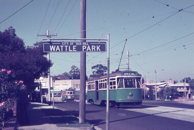
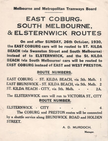
Document, Melbourne & Metropolitan Tramways Board (MMTB), "East Coburg South Melbourne & Elsternwick Routes", Oct. 1930
... & Elsternwick Routes", advising that from 16/10/1930, rerouting... & Elsternwick Routes", advising that from 16/10/1930, rerouting ...Notice to Passengers titled "East Coburg South Melbourne & Elsternwick Routes", advising that from 16/10/1930, rerouting of services - East Coburg to St Kilda Beach - route 1, East Brunswick - St Kilda Beach - route 2 and that Elsternwick cars route 4 will run to the City. Notes that the Coburg and Preston routes will be connected by a shuttle service along Holden St and Brunswick Road. Signed by A D Murdoch, Manager.Yields information changing of tram routes in Oct. 1930.Notice printed on quarto paper.tramways, buses, east coburg, south melbourne, elsternwick, st kilda beach, holden st, route 1, route 2, route 4, tram routes -
 Melbourne Tram Museum
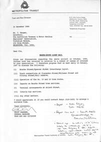
Letter, Metropolitan Transit Authority (MTA), "North - South Light Rail", 12/1986
... termination of route 15 and 16 trams at St Kilda Railway station... of route 15 and 16 trams at St Kilda Railway station. Includes two ...Letter from Geoff Carkeek, MTA Tram and Bus Division General Manager to J Harper, Secretary ATMOEA dated 24/12/1986 regarding the North - South Light Rail proposal (St Kilda and Port Melbourne lines) and the conversion to light rail, and impacts on existing tram services. Includes a note on the proposed termination of route 15 and 16 trams at St Kilda Railway station. Includes two drawings - St Kilda Station - Fitzroy St using the former VR St Kilda station forecourt rather than the platforms which were actually later used, and Clarendon St - Port Junction layout.Yields information about the conversion of the St Kilda Railway project.Letter - photocoped - 6 A4 and 2 A3 folded sheets, part stapled.light rail, conversion, st kilda, port junction, atmoea, st kilda railway station -
 Melbourne Tram Museum
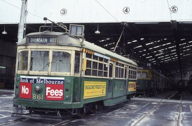
Album - Robert Thomson Slide Collection, "Melbourne 1-10th October 1993"
... Fitzroy St, St Kilda - tram 858 - route 16 RT003 "3" - Z class... Fitzroy St, St Kilda - tram 858 - route 16 RT003 "3" - Z class ...Photo - see pdf file for further information. Number Brief Description RT001 South Melbourne depot - tram 861 -"Domain Rd" RT002 Fitzroy St, St Kilda - tram 858 - route 16 RT003 "3" - Z class - tram 210 - "City" - route 05 RT004 Swanston St - tram 989 - "University" - route 8 RT005 Swanston St - tram 992 - "City" - route 6 RT006 Swanston St - tram 867 - "City" - route 8 RT007 "2" - Track Relay Wattletree Road RT008 "1" Track Relay Wattletree Road - tram 214 - route 05 RT009 Swanston St - tram 26 - "City - Swanston St" - route 6 RT010 Balaclava Junction - tram 76 - route 09 RT011 "6" - Track Relay Wattletree Road RT012 Fitzroy St - tram 2042 - "East Brunswick" route 96 RT013 Swanston St - tram 985 - "City" - route 8 RT014 "4" - Track Relay Wattletree Road, Malvern East, looking east to terminus at Burke Rd RT015 "5" - Track Relay Wattletree Road RT016 Collins St - tram 923 - "St Kilda Beach" - route 12 RT017 Victoria Pde Siding - tram 67 - "Special" - route 12 RT018 Nth Fitzroy Depot - trams 2037 & 2021 RT019 Park Street - tram 844 - "West Preston" - route 10 RT020 South Melb Beach Ter - tram 49 RT021 St Kilda Line - tram 67 - "East Brunswick" - route 96 RT022 Port Melb Terminus - tram 67 - "Port Melb'ne" - route 111 RT023 Port Melb Line - tram 2038 - "Exhibition Bldg" - route 111 RT024 Sth Melb Depot - tram 937 – “Restaurant" RT025 Collins St - tram 282 - "City" - route 42 RT026 Spring Street - tram 2100 - "City Spencer St" - route 86 RT027 Spring Street - tram 2093 - "Port Melbourne" - route 111 RT028 "1" New Track Spring St RT029 "2" track construction - Spring St RT030 "3" track construction - Spring St RT031 "4" track construction - Spring St RT032 "5" track construction - Spring St Demonstrates the work of Robert Thomson in photography, collection and/or production of slidesAssembled album in a black presentation folder of 32 colour slides, collected or produced by Robert Thomson. All photographs have been scanned and placed on the Museum's G drive. A list of all photographs with details has been compiled. melbourne, tramways, trams, track construction -
 Melbourne Tram Museum
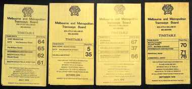
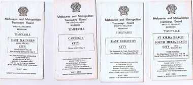
Ephemera - Timetables - MMTB trams - set of 8, Melbourne & Metropolitan Tramways Board (MMTB), 1976
... - routes 15, 16, 53, 55, 1, 2 and 4 - Sept. 1976 ... - routes 15, 16, 53, 55, 1, 2 and 4 - Sept. 1976 Yields information ...Timetables - provide information on ticketing, fares, and timing points, with a description of the route and a map. Not all services had been allocated a route number at the time. 1 - East Brighton - City and via William St - routes 64, 65, 62 and 61 - July 1976 2 - Malvern (Burke Rd) to City and via Wiliam St - routes 5 and 35 - Oct. 1976 3 - Carnegie - City and via William St - routes 67, 37, and 66 - July 1976 4 - Wattle Parke - City and Camberwell depot - routes 70, 71 and 76 - Sept. 1976 5 - Kew - Cotham Road to St Kilda Beach - route 69 - August 1976 6 - East Preston - via Bourke or La Trobe, and East Brunswick - routes 88, 14, 89. 90, 96, 95, and 97 - Feb. 1976 7 - Toorak - City and via William St - routes 8 and 38 - August 1976 8 - St Kilda Beach and South Melbourne Beach and via William St - routes 15, 16, 53, 55, 1, 2 and 4 - Sept. 1976 Yields information about MMTB tram services during the 1970s. Set of 8 MMTB tram timetables - multifolded printed on yellow paper.timetable, mmtb, wattle park, east brighton, malvern, carnegie, kew, east brunswick, toorak, st kilda beach, south melbourne beach, route 64, route 65, route 62, route 61, roure 5, route 35, route 67, route 37, route 66, route 70, route 71, route 76, route 69, route 88, route 96, route 8, route 38, route 15, route 1, route 2, route 55, route 53 -
 Melbourne Tram Museum
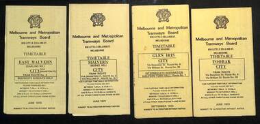
Ephemera - Timetables - MMTB trams - set of 10, Melbourne & Metropolitan Tramways Board (MMTB), 1973
... Melbourne Beach - City - routes 15, 16, 53, 55, 1, 2 and 4 - Sept... Melbourne Beach - City - routes 15, 16, 53, 55, 1, 2 and 4 - Sept ...MMTB Timetables - providing information on ticketing, fares, and timing points, with a description of the route and a map. Includes routes via William St - in the 30s 1 - East Malvern - City - route 3, bus route on Sundays only - June 1973 2 - Malvern Burke Road - City - route 5 and 35, - June 1973 3 - Glen Iris - City - route 6 and 36 - Sept. 1973 4 - Toorak - City - route 8 and 38 - June 1973 5 - South Melbourne and St Kilda Beach - City - routes 10, 12, and 17 - June 1973 6 - St Kilda Beach - South Melbourne Beach - City - routes 15, 16, 53, 55, 1, 2 and 4 - Sept. 1973 7 - Moreland - East Coburg - City - routes 1, 21, 15 and 22 - August 1973 8 - East Brighton - City - routes 64, 65, 62 and 61 - June 1973 9 - Carnegie - City routes 67, 37 and 66 - June 1973 10 - Kew Cotham Road - St Kilda Beach - route 69 - June 1973Yields information about MMTB tram services during 1973Set of 10 MMTB tram timetables - multifolded printed on yellow paper.timetable, mmtb, glen iris, malvern town hall, toorak, route 36, route 8, route 38, route 10, route 12, route 17, route 3, route 5, route 35, route 6, route 1, route 2, route 4, route 21, route 15, route 22, route 64, route 65, route 61, route 62, route 67, route 37, route 66, route 69 -
 Melbourne Tram Museum
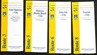
Ephemera - Timetable - The Met - set of 16, The Met, 1993
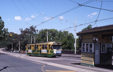
... - Wattle Park - Princes Bridge 15 - Route 72 - Camberwell - City 16... Park - Princes Bridge 15 - Route 72 - Camberwell - City 16 ...SSet of 16 The Met timetables, diagrammatic map, major stops and contact details. All dated May 1993 unless noted otherwise. 1 - Route 3 - East Malvern - City with a note that route 377 bus service replaces trams on Sunday. 2 - Route 5 - Malvern (Burke Rd) - City 3 - Route 6 - Glen Iris - City 4 - Route 8 - Toorak - City 5 - Route 10 - Sth Melbourne Beach and St Kilda Beach - West Preston 6 - Route 19 - North Coburg - City with a note that route 319 bus service to Gowrie and Upfield was included - ran Saturday afternoons and Sundays only. 7 - Route 42 - Mont Albert - City 8 - Route 48 - North Balwyn - City 9 - Route 55 - West Coburg - Domain Road interchange - with a note that route 68 operates via Elizabeth St on Sunday. 10 - Route 57- West Maribyrnong - City - with a note that route 357 bus services replaces trams on Sunday 11 - Route 59 - Airport West - City 12 - Route 64 - East Brighton - City 13 - Route 69 - Kew (Cotham Rd) - St Kilda Beach via Glenferrie Road 14 - Route 70 - Wattle Park - Princes Bridge 15 - Route 72 - Camberwell - City 16 - Route 82 - Moonee Ponds - Footscray and that route 223 bus replaces trams on Saturday afternoons and all day Sunday,Yields information about some of The Met tram services May 1993Set of 16 The Met timetables, DL size, printed in two colours.timetables, the met, route 8, route 3, route 5, route 6, route 10, route 19, route 42, route 48, route 55, route 57, route 59, route 64, route 69, route 70, route 72, route 82 -
 Ballarat Tramway Museum
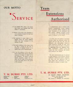
Pamphlet - Real Estate, T M Burke Pty Ltd, "Tram Extensions Authorised", 1936
... for purchase and notes the MMTB authorisation of new tram routes... routes. Gives details of the T M Burke services. Routes shown ...Wal Jack collected tramway and railway items for his collection. This pamphlet gives details of the Melbourne Public Transport system - rail, tram and bus in late 1936. Issued by T M Burke Pty Ltd of 840 Collins St Melbourne, Real Estate agents, shows the extensive sub-divisions where land was available for purchase and notes the MMTB authorisation of new tram routes. Gives details of the T M Burke services. Routes shown as authorised (16-7-1936) are: Keilor Road Essendon, High St North Balwyn and Hawthorn Road East Brighton. Demonstrates a Real Estate Sales pamphlet.Pamphlet - four colours printed on cream coloured bond paper, folded vertically originally.letter, wal jack, buninyong, railway lines -
 Ballarat Tramway Museum
Ephemera - Timetable/s, Melbourne and Metropolitan Tramways Board (MMTB), Set of 24 MMTB Melbourne tram timetables, 1969
... - Moreland and 1 & 21 - East Coburg .10 - Route - 15 & 16 - St Kilda... .10 - Route - 15 & 16 - St Kilda Beach and 1 & 2A - South ...Set of 24 MMTB timetables for various routes, dated July 1969. Generally includes Sat and Suns, Good Friday and Christmas day as well as weekdays, unless noted otherwise. Also includes a map of the route, detailed time points, sections, connecting services, fares, and organisation address - 616 Little Collins St. Melbourne. Have been folded into ten portions. All on white paper unless noted otherwise. Items shown with an # - have a sticker modifying timetable information details on the front page. 1154.1 - Route 4 - Carnegie - City .2 - Route 4D - East Malvern (Darling Road) - City # .3 - Route 5 - Malvern Burk Road, - City # .4 - Route 6 - Glen Iris - City # .5 - Route 7 - Camberwell - City # .6 - Route 8 - Toorak - City # .7 - Routes 9, 10 and 12 - South Melbourne and St Kilda Beach - City (Brunswick St.) - via Collins St. .8 - Routes 10, 11 - West Preston and routes 9 & 9A Northcote .9 - Routes 15 & 22 - Moreland and 1 & 21 - East Coburg .10 - Route - 15 & 16 - St Kilda Beach and 1 & 2A - South Melbourne Beach - via Swanston St. .11 - Route 19 - North Coburg - City # .12 - Route 42 - Mont Albert - City # .13 - Routes 48 - North Balwyn and Burwood - City .14 - as above, but for Saturdays and Sundays on pink paper .15 - Routes 55 & 56, West Coburg - City - (William St.) - Domain Road. .16 - Route 57 - West Maribyrnong - City .17 - Route 59 - Essendon (Aerodrome) - City .18 - Route 64 & 65 - East Brighton - City .19 - Route 69 - Kew Cotham Road - St. Kilda Beach # .20 - Route 70 - Wattle Park - City # .21 - Routes 77 - Prahran - City, 78 - North Richmond - Prahran, 79 - North Richmond - St Kilda Beach .22 - Route 82 - Footscray to Moonee Ponds .23 - Route 88 - East Preston - City and Route 96, East Brunswick - City .24 - as above but for Saturdays and Sundays on pink paper. Images of a sample of documents added 16-11-2013.mmtb, timetables, melbourne -
 Melbourne Tram Museum
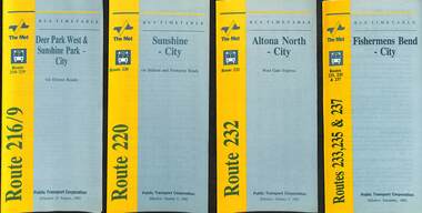
Ephemera - Timetable - bus - The Met - set of 24, The Met, 1992 & 1993
... Kew - City or Box Hill 16 - Route 285 - The Pines - Box Hill... or Box Hill 16 - Route 285 - The Pines - Box Hill 17 - Route 286 ...SSet of 24 The Met bus timetables, with diagrammatic map, major stops and contact details. All dated during1993 unless noted otherwise. 1 - Route 216/9 - Deer Park West & Sunshine Park - City 2 - Route 220 - Sunshine - City - 1992 3 - Route 232 - Altona North - City - 1992 4 - Route 233 - Fishermens Bend - City - 1992 5 - Route 254 - Northland Shopping Centre - City - 1992 6 - Route 256 - La Trobe Uni - City - 1992 7 - Routes 258 & 259 - Northland Shopping Centre, and La Trobe Uni - City via Eastern Freeway - 1992 8 - Route 260 etc - Deep Creek Templestow - Donvale - City 9 - Route 264 - Mitcham, Donvale City 10 - Route 265 - Deep Creek - City 11 - Route 602 - Brighton - city 12 - Route 269, 291 and 296 - Greensborough, Heidelberg & Newmans Road to Box Hill 13 - Route 272 - Warrandyte - City 14 - Route 276 & 278 - Warrandyte - City 15 - Route 284 & 270 - East Kew - City or Box Hill 16 - Route 285 - The Pines - Box Hill 17 - Route 286 & 288 - The Pines and Templestowe - Box Hill 18 - Route 290 - North Nunawading - Box Hill 19 - Route 292 etc - Box Hill, Deep Creek, Ringwood, Warrandyte 20 - Route 301, 281 315 - Ringwood, Park Orchards and Donvale - City 21 - Route 305 - Box Hill - Ringwood 22 - Route 366 & 367 - Ringwood - Croydon 23 - Route 600 - St Kilda - Brighton Beach - 1992 24 - Route 601 - Gardenvale - City - 1992Yields information about some of The Met bus services 1993Set of 24 The Met timetables, DL size, printed in two colours.timetables, the met, route 216, route 220, route 232, route 233, route 254, route 258, route 259, route 260, route 264, route 265, route 256, route 602, route 269, route 272, route 276, route 284, route 270, route 285, route 286, route 288, route 290, route 292, route 301, route 305, route 366, route 367, route 600, route 601 -
St Vincent's Hospital Melbourne Archives
Album - Agnes McLean photograph album, Souvenir St Vincent's Melbourne, the foundation stone new wing 1928
... 14, St V's nurses. Page 15, The Subway. Page 16, En route... 14, St V's nurses. Page 15, The Subway. Page 16, En route ...Images in the album are related to the laying of the foundation stone of St Vincent's new wing in 1928 as well as the royal visit of the Duke and Duchess of York in 1927. A loose newspaper clipping contained in the album titled "Fitzroy's Welcome" provides information on the royal visit which extended into Fitzroy, Collingwood and Richmond. A minute photo on page 18 of the album shows an image of the royal yacht. Album contents and descriptions written: Page 1, Mother Mary Aikenhead foundress of the Sisters of Charity. Page 2, Mother Mary Berchmans foundress of St Vincent's. Page 3, The Papal Legate Cardinal Cerretti XX1X eucharistic congress laying of the foundation stone SVHM1928. Page 4, His Grace the Archbishop of Melbourne the most Rev Daniel Mannix 1928. Page 5, The stand from which the cardinal addressed the meeting. Page 6, En route to "Stand" SVH. Page 7, The stone ready to be blessed. Page 8, The Cardinal going to bless the stone. Page 9, The blessing of the stone. Page 10, Listening to the Cardinal. Page 11, The mallet and the trowel used. Page 12, The stone is well and truly laid, Page 13, Via the enclosure. Page 14, St V's nurses. Page 15, The Subway. Page 16, En route to Reception Hall. Page 17, The Reception Hall. Page 18, The Stage Garlands, CLC students entertained. Page 19, Royal visit His RH the Duke of York. Page 20, The Duchess of York. Page 21, The living check. Page 22, The guard of honour SVH nurses. Page 23, Fire station en fete opposite SVH. Page 24, Victoria Parade for a Royal Visit.Each page has script style black ink descriptions of the photograph.archbishop daniel mannix, mother mary berchmans daly, cardinal bonaventura cerretti, duke of york, duchess of york, mother mary aikenhead, st vincent's hospital melbourne, nurses, victoria parade, eastern hill fire station., tunnels, brenan hall -
 Melbourne Tram Museum
Map, Melbourne & Metropolitan Tramways Board (MMTB), MMTB Route Maps, 1979
... and route 2 and St Kilda Beach routes 15, 16, and 55 otherwise shows... and route 2 and St Kilda Beach routes 15, 16, and 55 otherwise shows ...Series of colour maps for various tram and bus routes, dated 1979. Also contained, not scanned are letters, reports, and specifications for printing these maps for use in shelters etc. Some have the Transport Information Centre telephone printed on them. Some are finished with a plastic laminate finish on either one or both sides. Show the major cross streets, parks, schools, other tram routes, major stop numbers, and railway lines. See also item 3909 for another example of these. Trams 1 - City route guide - R9/77 - showing all route numbers and destinations that passed through the CBD. 2 - Bourke St tram routes - R4/77 - East Brunswick Blyth St and East Preston Tyler St and intermediate routes, routes 95, 96, 97, 90, 89 and 88. 3 - Malvern, East Malvern, Carnegie, and East Brighton Tram Routes (from St Kilda Junction) - R1/79 - shows routes 5, 3, 67, 66, 61, 62, and 64. 4 - Elizabeth St tram routes - R12/77 - Essendon Airport, West Maribyrnong, North Coburg lines, routes 50, 58, 60, 54, 57, 52. 49, 59, 18, 20 and 19 5 - Flinders St tram routes - R5/78 - North Balwyn, East Burwood, routes 48, 40, 41, Hartwell, 28, 74 and 75 6 - Kew - St Kilda Beach - R1/79 - Route 69. 7 - Mont - Albert City - R11/77, shows routes 43. 47. 45. 44 8 - St Kilda Rd Tram Routes R12/77 - details South Melbourne Beach, route 1 and route 2 and St Kilda Beach routes 15, 16, and 55 otherwise shows where the various routes branch off St Kilda Road 9 - Batman Ave tram routes - R9/77 - Wattle Park, North Richmond and Prahran - routes 70, 71, 78 and 79. 10 - Footscray - Moonee Ponds - R3/81 - Route 82 11 - Swanston St tram guide - R1/79 - lists all routes and route numbers that branch or cross Swanston St between Grattan St and St Kilda Junction. 12 - Toorak Camberwell and Glen Iris tram route with Camberwell Junction and Malvern Town Hall, R1/79, routes 8, 7, 6, 72, and 73 shown. 13 - West Preston - Beach tram routes - R12/77 - routes 10, 11, 9 and 12, 14 - William St tram routes - R12/77 - Route 55, 56, and 63 - South Melbourne Depot and Domain. Buses 1 - Footscray, Sunshine, Deer Park, Nth Altona & Fishermans Bend - R2/79 2 - Box Hill bus routes to Templestowe, Heidelberg & East Kew - R6/78 - notes superseded by R3/82 3 - Plan of Russell St Melbourne bus departure bays. 4 - Box Hill, Mitcham & Ringwood bus routes to East Doncaster & Warrandyte - R3/82 5 - City - Warrandyte & East Doncaster bus routes - R3/82 & R6/78 6 - Bulleen - City - Port Melbourne - Garden City Bus route - R6/78 7 - North Altona - City bus route - 11/78 8 - Clifton Hill - Elsternwick - R2/79 9 - La Trobe - Northland - West Heidelberg - City Bus Service via East Freeway - 11/79 and R3/81 10 - Box Hill, Mitcham & Ringwood Bus Routes to East Doncaster & Warrandyte - R10/84 - with the Metropolitan Transit logo.Yields information about tram and bus routes in late 1970s early 1980s.Book - brown comb binding, card and clear plastic covers containing both bound and unbound maps and documents.K C Painter on front cover in ink.tramways, mmtb, tram routes, maps, bus routes, route numbers, routes, route guide -
 Melbourne Tram Museum
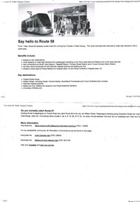
Pamphlet, Public Transport Victoria (PTV), "We're growing with Melbourne", "Say hello to Route 58", Apr. 2017
... of Remembrance on the front. Dated 02/16 - gives a map of all route... 55, with a giraffe on the front, dated 02/16. .6 - Route 58 ...Set of two black and white pamphlets downloaded from the PTV website, 9/4/2017 regarding the introduction of Route 58, amalgamation of route 55 and 8 on 1/5/17. .1 - "Say hello to Route 58" - two pages going an outline of the new route and all the benefits! .2 - "We're growing with Melbourne" - pamphlet issued by PTV - 6 fold A3 sheet, printed on off white paper, full colour - with changes out lined and a map of Melbourne tram services - see i2 for pdf copy. Two copies held .3 - Pamphlet, printed and cut for use in trams around passenger hanging rails, titled "Say hello to the new Route 58" - on rear gives the new routes and key changes and what to do if you catch route 8? Two copies held - 2 copies held. .4 - Folded DL size sheet - vertical - titled "Tram Route Guide 8 Moreland to Toorak" with a photo of the Shrine of Remembrance on the front. Dated 02/16 - gives a map of all route stops, zones, estimated frequencies, with notes on night services and Myki. .5 - As for .4, but for route 55, with a giraffe on the front, dated 02/16. .6 - Route 58 guide - pending publication at time of entry. There were other service changes as well to other routes. Have Yarra Trams, PTV and State Government logos on the various documents.trams, tramways, yarra trams, ptv, route 8, route 6, route 55, route 58, map, route guide -
 Melbourne Tram Museum
Ephemera - Tram Route Guides, Public Transport Victoria (PTV), "Tram Route Guide", 4/2017 to 5/2018
... - Routes 48, 78, 75, 78 and 109 .5 - Set E - Routes 5, 6, 16, 58... - Routes 48, 78, 75, 78 and 109 .5 - Set E - Routes 5, 6, 16, 58 ...Set of 6 Tram Route Guides, published during April 2017, following the introduction of route 58. Consolidates into 6 folders the previous individual guides for each route.. Each comprises a A2 folded sheet, full colour printed on non-gloss paper. Has the Yarra Trams and PTV logos, listing the stops, interchanges with bus and other tram services, ticketing zones, estimated frequencies with adverts for Night tram services, TramTracker and Myki tickets. On the rear is a large map, a list of the other route guides and a short summary of the routes list in the guide. .1 - Set A - Routes 1, 6, 11, 19 and 86 .2 - Set B - Routes 57, 58, 59 and 82 .3 - Set C - Routes 3, 3a, 64 and 67 .4 - Set D - Routes 48, 78, 75, 78 and 109 .5 - Set E - Routes 5, 6, 16, 58 and 72 .6 - Set F - Routes 12, 30, 35, 96 .7 - as for .1 A - dated May 2017 .8 - as for .2 B- dated 20 May 2018 .9 - as for .3 C- dated 20 May 2018 .10 - as for .4 D - dated 20 May 2018 .11 - as for .6 F - dated 20 May 2018 (E was not updated as at 17-7-2018) .12 - as for .1, dated 16/9/2018. .13 - Set A - dated 1 June 2019 .14 - Set B - dated 1 Jan 2019 .15 - Set C - dated 1 Jan 2019 .16 - Set D - dated 1 June 2019 .17 - Set E - dated 1 Jan 2019 .18 - Set F - dated 1 Jan 2019 .19 - Set F - dated 1 June 2019 Collected during 2019, added 2/1/2020.trams, tramways, timetables, maps, route 1, route 3, route 3a, route 5, route 6, route 8, route 11, route 12, route 30, route 35, route 19, route 48, route 57, route 58, route 59, route 70, route 72, route 75, route 78, route 82, route 86, route 96, route 109, east coburg, south melbourne, malvern, glen iris, moreland, toorak, west maribyrnong, wattle park, docklands, camberwell, vermont south, footscray, moonee ponds -
 Ballarat Tramway Museum
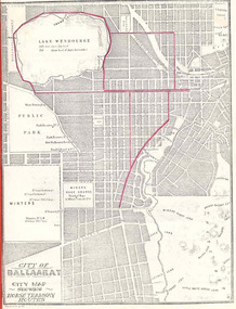
Book, City of Ballaarat, "Mayors Special Report Ballarat Tramways", Sep. 1971
... , showing route numbers, destinations and existing tramway routes..., showing route numbers, destinations and existing tramway routes ...Historically significant for at the time it demonstrated aspects of the evolution of Ballarat Tramways and yields information about the formation of the tramways, the Councils viewpoint and has a strong association with the Mayor of the time.Twenty two page book, produced by photocopying, side stapled and bound with a red plastic binding, titled "Mayor's Special Report Ballarat Tramways", dated 20 September 1971 for presentation to the City of Ballaarat Council Meeting 27 Sept. 1971 and signed by the Mayor, J.A.Chisholm. Note pages 18 and 19 have been reversed. Comprises: Page 1 - map (image 1829i1) - of Ballarat (Ballaarat) showing the horse tram routes in red (appear to have been drawn in with a red pencil). Note the Sebastopol route terminates at Rubicon St. Page 3 - letter to the City Councillors from the Mayor Page 4 - Outline of the "The Ballarat Tramway System" Pages 5 - 7 - Conditions for tendering the horse tram system within the City of Ballarat" Pages 8 - 11 - Specifications and Agreement for the Ballaarat Tramways (horse trams). pages 12 - 19 - Memorandum of Agreement with the British Insulated Wire Company (later ESCo) Page 20 - Copy of letter from the Secretary of the SEC to the Minister of Fuel and Power, dated 10 Sept. 1971 advising of the formal abandonment of the Ballarat and Bendigo tramway systems. Page 21 - five photos (image 1829i3) of trams in Ballarat, including the bogie tram decorated for the Queens visit, courtesy of Mr. L. J. Denmead, Tramways Superintendent. Page 22 - Plan (image 1829i2) of Ballarat Bus Services, showing route numbers, destinations and existing tramway routes. 3rd copy added 16/7/2010trams, tramways, city of ballaarat, mayor's reports, ballaarat tramway company, british insulated wire company, esco, bus services, sec -
 Melbourne Tram Museum
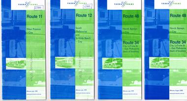
Ephemera - Timetable, Yarra Trams, Set of 15 Yarra Trams timetables, 7/1999 to 9/2001
... - September 2001 - 48 pages. .16 - Route 11 - West Preston - City... and 12 - September 2001 - 48 pages. .16 - Route 11 - West ...Set of 15 Yarra Trams timetables, blue green cover with route number on cover, giving details of popular destination, check points, use of Metcards and contact details, tram hire, frequency, Some include maps. .1 - Route 11 - West Preston - City - July 1999 - 24 Pages .2 - Route 12 - South Melbourne and St Kilda Beach - City - July 1999 - 24 pages .3 - Route 48 and Route 34 - North Balwyn - City or via Latrobe St - East Melbourne, includes references to Routes 23, 24, 27 and 30 - July 1999 - 28 pages, includes a small map. .4 - ditto - August 2000 .5 - ditto - September 2001 .6 - Route 70 - Wattle Park - City - October 1999 - 24 pages .7 - Route 70 - Wattle Park - City via MCG - December 2000 - 24 pages - includes a map .8 - Route 75 - East Burwood - City - July 1999 - - 24 pages .9 - ditto - August 2000 .10 - Route 86 - Bundoora RMIT - Colonial Stadium via Bourke St - March 2000 - 28 page. .11 - Route 96 - St Kilda Beach - East Brunswick -March 2000 - 24 pages .12 - Route 109 - Mont Albert - Port Melbourne - July 1999 - includes references to route 23, 24, 27. 30 and 34 - 36 pages .13 - Route 109 - ditto includes La Trobe St services - September 2001 - 36 pages .14 - Route 112 - South Melbourne - St Kilda Beach to West Preston via City, including temporary combination of routes 11 and 12, route 11 and Route 12 - August 2000 - 48 pages. .15 - Route 112 - notes that it the combination of Routes 11 and 12 - September 2001 - 48 pages. .16 - Route 11 - West Preston - City - Nov. 1998 - 24 pages .17 - Route 48 - North Balwyn - City - Dec. 1998 - 24 pages .18 - Route 34 and 48 - North Balwyn - City and City LaTrobe - East Melbourne - August 2000 - 32 pages .19 - Route 109 - Port Melbourne - Mont Albert - Nov. 1998 - 24 pages.Some have notes such as "OPR", and number notes and notes written inside about changes or errors in ink. See History.trams, tramways, yarra trams, tram services, timetables, route 11, route 48, route 34, route 23, route 24, route 27, route 30, route 70, route 75, route 86, route 96, route 109, route 112 -
 Melbourne Tram Museum
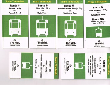
Ephemera - Timetable, The Met, Set of 18 Tram Timetables, produced by The Met, 1986 - 1988
... Hawthorn Road - 14/9/1987 .10 - Route 67 - Carnegie - City via... and all day Sunday. 3/8/1987 .16 - Route 88 - Bundoora - City via ...Set of 18 Tram Timetables, produced by The Met for various routes, white cover with two green, multi fold horizontal sheet, giving a route map, description, notes, time points, information contact details and types of tickets (Neighbourhood and Travelcards) and where they could be purchased. .1 - Route 3 - East Malvern - City via Balaclava Road - replaced by bus 377 on Sundays - dated 14/9/1987 .2 - Route 5 - Malvern Burke Road - City via Wattletree Road - 19/6/1988 .3 - Route 6 - Glen Iris - City via High St - 19/6/1988 .4 - Route 8 - Toorak - City via Toorak Road - 19/6/1988 .5 - Route 19 - North Coburg - City via Elizabeth St including connecting bus service to Gowrie and Upfield stations - 11/3/1987 .6 - Route 55 - West Coburg - Domain Interchange via William St - 11/2/1987 .7 - Route 57 - West Maribyrnong - City via North Melbourne - Route 357 bus replaces tram on Sunday - 1/12/1986 .8 - Route 59 - Airport West - City via Essendon -1/12/1986 .9 - Route 64 - East Brighton - City via Hawthorn Road - 14/9/1987 .10 - Route 67 - Carnegie - City via Glenhuntly Road - 14/9/1987 .11 - Route 69 - Kew (Cotham Road) - St Kilda Beach via Glenferrie Road - 19/6/1988 .12- Route 72 - Camberwell - City via Malvern Road - 19/6/1988 .13 - Route 75 - East Burwood - City via Flinders St - 15/2/1988 .14 - Route 78, Route 79, North Richmond - Prahran via Chapel St and North Richmond - St Kilda Beach via Chapel St - 13/7/1987 .15 - Route 82 - Footscray Moonee Ponds via Highpoint City and Route 223 bus replacement for Saturday afternoon and all day Sunday. 3/8/1987 .16 - Route 88 - Bundoora - City via Preston .17 - Route 96 - East Brunswick - St Kilda Beach via Bourke St City - 22/11/1987 .18 - Route 111 - Royal Exhibition Buildings - Port Melbourne via Bourke St City - 20/12/1987. (2nd copy added 1/4/20201( .19 - Route 600 - St Kilda - Middle Brighton via Elwood - 1/12/1986 Full Image of .5 added 9/4/17 following a query about route 19 timetables - see image i6.trams, tramways, timetables, tickets, tram services, route 3, route 5, route 6, route 19, route 55, route 57, route 59, route 64, route 8, route 67, route 69, route 72, route 75, route 78, route 78, route 79, route 82, route 88, route 86, route 111, route 600 -
 Flagstaff Hill Maritime Museum and Village
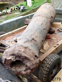
Weapon - Cannon, circa 1825
HISTORICAL INFORMATION In an article dated 26 March 1963, the Warrnambool Standard reported: “A cannon which has lain on the ocean floor since the barque, Children, was wrecked at Childer’s Cove on January 15, 1839, was raised by three Warrnambool skindivers at the week-end…The cannon, weighing about 750 lb. and 4-ft. 6-in. in length…is in excellent order considering the length of time it has remained under-water”. No conservation measures were taken at that time, other than chipping off the marine growth with hammers and cold chisels. The minutes for the 4 February 1974 meeting of the Flagstaff Hill Planning Board recorded that “a cannon recovered some time ago was lying in the garden of [one of the three original divers] and that it could be picked up at any time”. Peter Ronald, past Manager and Diver for Flagstaff Hill, notes that the CHILDREN cannon would have been recovered by the other divers around 1964. When the cannon came into care of Flagstaff Hill it was given basic conservation relevant to the time. (At the same meeting the Board was advised of the recovery of an anchor from the wreck of the CHILDREN by Flagstaff Hill divers (Peter Ronald, Colin Goodall and Gary Hayden, and Hank Howey and Andrew Coffee), and its interim relocation in the sea at the end of the Warrnambool Breakwater while awaiting conservation). The CHILDREN was owned by the pioneering Henty family of Portland. She was en route from Launceston to Adelaide, when she foundered in rough conditions at Childers Cove on 14 January 1839. The CHILDREN was a small three-masted barque, only 29 metres long and 254 tons weight, with 14 crew members and 24 passengers (including 9 children) on board. The ship was also carrying an awkwardly ballasted cargo of 1500 sheep, 8 bullocks, 7 horses, 5000 London house bricks, 6 whaling boats, and general trade goods. When the CHILDREN was driven into the limestone stack at the entrance to the cove, the seas smashed her into pieces within half an hour, and 16 lives were lost. The CHILDREN was an all-wooden ship, built in 1825 at Liverpool, and her shipwreck in 1839 is one of colonial Victoria’s earliest and most significant maritime disasters. There is little left to mark the tragedy on the seabed now, apart from some of the house bricks intended for the Henty’s Portland Bay settlement. Despite its poor condition, the CHILDREN’s signal cannon remains an important and interpretable record of her demise, (along with her anchor, the bottom half of her ship’s bell, and portions of a brass porthole - artefacts that are also in the Flagstaff Hill collection). In 2015 the CHILDREN cannon will undergo further conservation. (Conservation Management Plan for Victorian Guns and Cannon, South Western Victoria, May 2008, ref W/F/06) The shipwreck of the CHILDREN is of state significance — Victorian Heritage Register No. S116.A 1.3 metre iron 6pdr cannon recovered from the wreck of the CHILDREN. The shape of the cannon tapers from a thick round breech to a flared muzzle, with an 8 centimetre bore, and two side trunnions for pivoting on a wooden gun carriage. It was recovered from the shipwreck site of the CHILDREN by local divers in 1963. This small muzzle-loading signal cannon is in poor and unrestored condition. The cannon’s upper profile of smooth grey metal casing has corroded off, leaving an extensively oxidised rough red surface of crumbling iron. The bottom half of the cannon remains intact although the outer smooth casing also appears to be separating from the iron core of the barrel. Original grey casting is also missing from the breech and muzzle ends of the cannon. Corrosion and spalling of the upper surface layer of the cannon has removed the maker’s marks and specificationsflagstaff hill, warrnambool, shipwrecked coast, flagstaff hill maritime museum, maritime museum, shipwreck coast, flagstaff hill maritime village, great ocean road, the children, ship’s cannon, signal cannon, childers cove, 1839 shipwreck, conservation of marine artefactsm, shipwreck-coast, flagstaff-hill-maritime-village, cannon, 6pdr small bore cannon, children cannon, defence, children, shipwreck, 1839 -
 Flagstaff Hill Maritime Museum and Village
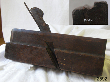
Tool - Moulding Plane, Charles Nurse, 1860-1900
The original Nurse family business began in 1841 in Maidstone Kent until 1861 where they were plane makers, moving to London in 1887 the company became C Nurse & Co. And continued until 1937 under that name at the (Invicta works). The majority of their plane making was done in London but there are Sheffield and Brighton marks on their tools as well. The company was not only wood plane makers but tool makers in general with the Charles Nurse & Co catalogue having 350 pages of tools for sale of varying types for different building trades and over 138 pages dedicated to woodworking tools. Records show that the company was at 182 Walworth Road London from 1887-1949. However, they had several retail outlets before this time and records indicate before 1887 Charles Nurse was at 32 Mill St Maidstone Kent, from 1844 -1860 but were in business before then. Also in Brighton at 135 Queens Road from 1865 -1871 and at 3 Mill Street Maidstone, again from 1872 - 1889 listed on records of the time as “plane and tool makers.”A vintage item made by a significant tool maker and retailer from the middle of the nineteenth century and into the first half of the twentieth century. These items were made commercially for firms and individuals that worked in wood and needed a tool that could produce an ornamental finish to timber. The tool was used before electric or mechanical routers or spindle moulders came into use. They were used by craftsmen to produce decorative mouldings by hand. These profiled planes came in various shapes and sizes. A significant tool that today is quite rare and sought after by collectors. It gives us a snapshot of how furniture and other decorative finishes were created on timber by the use of hand tools only. Moulding plane Side Bead - Single Box Size 5/16 Maker Charles and Co 1863 Stamped W. Burden (previous owner)flagstaff hill, warrnambool, shipwrecked-coast, flagstaff-hill, flagstaff-hill-maritime-museum, maritime-museum, shipwreck-coast, flagstaff-hill-maritime-village