Showing 241 items
matching site survey
-
 Eltham District Historical Society Inc
Folder, Victorian Goldfields Project: Historic gold mining sites in St Andrews mining division, 1999
Heritage site report and gazetteer by David Bannear, head consultant for archealogy for the Department of Natural Resources and Environment. Includes information on the Warrandyte Goldfield and the Caledonia Goldfield, Queenstown (now known as St Andrews), One Tree Hill, Kingston (now known as Panton Hill), Kangaroo Grounds, You You Hill, Kingstown, South Morang, Nillumbik, (now known as Diamond Creek), Steele's Creek, Yarrambet and Kinglake. Photocopy of map headed: Location of mines and reefs from Geological survey of Victoria, Yan Yean with the Diamond Creek prominant on the map. no date35 page report with map and print out of cover letter (email form) from donorcaledonian gold fields, caledonina gold field, david bannear, gold mining, harry gilham collection, queenstown, st andrews, warrandyte goldfield -
 Eltham District Historical Society Inc
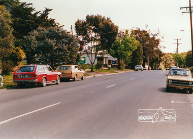
Photograph, Looking west near 942 Main Road, Hurstbridge, c. Oct 1987, 1987
Yvonne's Dressmaking and Alteration Service at 942 Main Road. Formerly a bakery, the building was demolished in 1990 and is now the site of Hurstbridge Saddlery. The milkbar is down the road, brick wall with a blue sign on it. There's still an older house next to the milkbar, but that's hidden from view in this shot as it's further back from the road. Date based on other similar display panels visible in images of the Shire of Eltham display at the Eltham Community Festival, 7 November 1987. Shire of Eltham Engineering Department Providing the resources to undertake • Survey, design, consultation • Road construction and maintenance • Bridge construction and maintenance • Street sweeping • Drain and pit cleaning • Traffic engineering installation and maintenance • Garbage collection • Tip management, land reclamation and beautification • Maintenance of community buildings • Provision of community and recreation facilitiesPhoto print mounted on carddisplay panel, eltham festival, heidelberg-kinglake road, hurstbridge, hurstbridge milk bar, infrastructure, main road, mm, shire of eltham, yvonne's dressmaking and alteration service -
 Bendigo Military Museum
photograph - Fortuna - 1st Year of Army Occupation in Bendigo, 1942
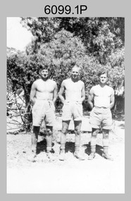
This is a set of 17 photographs taken during the first year of Army occupation at Fortuna, Bendigo in 1942. The photos provide an insight into the preparatory work performed on the Fortuna Villa and surrounding buildings, by the Working Party 5th Army Troop and Ordnance Training Depot, before its occupation by personnel from LHQ Cartographic Company, Royal Australian Survey Corps. The annotation on the back of Photos .9P and .10P is misspelt. The correct spelling is ‘Nell Gwynne’. The poppet head of the Central Nell Gwynne mine is still an iconic landmark in Bendigo, lying just down the road from the poppet head lookout at Victoria Hill. The Central Nell Gwynne was the premier mine of Bendigo's 1930s mining revival and is of high historical value, due to the extensive and relatively intact features which remain at the site. The annotation on the back of Photo .17P is incorrect. The location of HQ 5th Army Troop was ‘Reynard St, Coburg.’ By late 1941 as Japan extended its control throughout Indo-China, resolving the accommodation problem of AHQ Cartographic Company located in Melbourne became more urgent. The steady Japanese advance made the bombing of Melbourne no longer a remote possibility, and in accordance with a general policy of dispersion, the Deputy Chief of the General Staff, Major General Sidney Rowell instructed Major William Sarll, in the interests of security of plant and to provide against possible damage of air attack, to investigate suitable safer inland accommodation for AHQ Cartographic Company. Major Sarll inspected many properties before finding one that would meet the requirements of the Cartographic Company. In late 1941, he came to inspect Fortuna, a rambling old mansion with about fifteen acres of ground in central Bendigo. Initially there was no intention to occupy the site beyond the end of the war, although Major Sarll's report to the Director of Survey noted many advantages in moving the Company to Bendigo. Major General Rowell quickly approved the selection of Fortuna before other authorities, which were investigating the evacuation of school children, could get in ahead of the Cartographic Company. On 23 March 1942, the Commonwealth of Australia, under the provisions of the National Security Act of 1939, took possession of the house, the old battery buildings and the fifteen acres of grounds. Under Warrant Officer J. Trist’s direction, over fifty Parks and Works tradesmen completed building works necessary to accommodate the Survey Corps’ military, map making and printing requirements. The building program was still under way when the first officer, Lieutenant Ralph Westgarth, arrived in May 1942 with the advance party which received and positioned all equipment as it came up from Melbourne in semi-trailers. Once the equipment was installed the rest of the Cartographic Company completed its shift to Bendigo by 11th June 1942. The first year of the Survey Corps’ occupation of Fortuna is covered in more detail with additional historic photographs, in pages 17-22 of Valerie Lovejoy’s book 'Mapmakers of Fortuna – A history of the Army Survey Regiment’ ISBN: 0-646-42120-4.This is a set of 17 photographs taken during the first year of Army Occupation at Fortuna, Bendigo in 1942. The black and white photographs were printed on photographic paper and are part of the Army Survey Regiment’s Collection. The photographs were scanned at 300 dpi. .1) - Photo, black & white, 1942. Bendigo Parks and Works tradesmen at Fortuna. L to R: Cliff Day, Ernie Arnold, Norm? .2) - Photo, black & white, 1942. “Don” - possibly SGT Don Sutcliffe. Fortuna, Bendigo. .3) - Photo, black & white, 1942. Parks and Works tradesmen in garden at Fortuna, Bendigo. L to R: Fred & Ernie. .4) - Photo, black & white, 1942. Benny Jack Williams at Fortuna, Bendigo. Accommodation tents were erected above the lake, which later became the parade ground. .5) - Photo, black & white, 1942. Working dress - Giggle suits. Parks and Works tradesmen at Fortuna, Bendigo. L to R: Cliff and Harry on big roof. .6) - Photo, black & white, 1942. Parks and Works tradesmen at Fortuna, Bendigo. Ted on big roof. .7) - Photo, black & white, 1942. Gold crusher battery just behind Fortuna. .8) - Photo, black & white, 1942. Scene of Bendigo from Fortuna. .9) - Photo, black & white, 1942. Nell Gwynne Mine from mullock heap at Victoria Hill near Fortuna, Bendigo. .10) - Photo, black & white, 1942. Nell Gwynne Mine and crusher near Fortuna, Bendigo. .11) - Photo, black & white, 1942. Sluicing for gold at Eaglehawk. .12) - Photo, black & white, 1942. Fortuna, Bendigo taken from the far side of tennis courts. .13) - Photo, black & white, 1942. Fortuna, Bendigo & its reflection from across the lake. .14) - Photo, black & white, 1942. Fortuna, Bendigo from the fishpond. .15) - Photo, black & white, 1942. Fortuna, Bendigo. .16) - Photo, black & white, 1942. First Fortuna Football Team at unknown location. L to R: 5th Bob Wright, 11th SGT Don Sutcliffe. .17) - Photo, black & white, 1942. Working Party from 5th Army Troop and Ordnance Training Depot at Fortuna, Bendigo.Some personnel are identified. Annotated with date within photos. .1) – Annotated on back ‘Cliff, Ernie, Norm, Dec ‘42. Cliff Day - dairy farmer, plasterers’ labourer. Ernie Arnold – hard plasterer. Norm? - QM Store for tools etc. QM Store was the Stables.’ .2) - Annotated on back ‘Don. Fortuna 1942’ .3) - Annotated on back ‘Fred & Ernie. Dec 1942. Carpenters. Note the state of the gardens.’ .4) - Annotated on back ‘Benny Jack Williams Fortuna Bendigo. Tents were erected where present day parade ground is above the lake.’ .5) - Annotated on back ‘Working dress - Giggle suits. June 42. Cliff and Harry on big roof. This photo was taken as the ventilating ridge was being installed on the building housing the printing machines. The machines were installed later by civilian labour when building was complete.’ .6) - Annotated on back ‘Ted on big roof Fortuna Bendigo.’ .7) - Annotated on back ‘Gold crusher battery – Bendigo for slay heap – 1942. 12 stamp battery. Just behind Fortuna. Was working at night when the “Army” came to Bendigo. Later removed to “Coolgardie - WA. Present site of Southern Cross TV.’ .8) - Annotated on back ‘Scene of Bendigo from Fortuna. June 1942.’ .9) - Annotated on back ‘Nell Gwyne Mine from mullock heap (Victoria Hill) Sept 1942.’ .10) - Annotated on back ‘Nell Gwyne Mine and crusher September 1942.’ .11) - Annotated on back ‘Sluicing for gold at Eaglehawk. August 1942.’ .12) - Annotated on back ‘Fortuna Bendigo 1942. Taken from far side of tennis courts.’ .13) - Annotated on back ‘ “Fortuna” across the lake & reflection.’ .14) - Annotated on back ‘Fortuna from fishpond June 1942.’ .15) - Annotated on back ‘Fortuna Dec 1942.’ .16) - Annotated on front ‘X’ x2. Annotated on back First Fortuna Football Team 1942‘Bob Wright’, ‘SGT Don Sutcliffe’. .17) - Annotated ‘Working Party at Fortuna before one of the drafts’, Working Party 5th Army Troop and Ordnance Training Depot Showgrounds, now the Sportsground Bendigo’, ‘HQ of 5th Army Troop was Reynards Rd, Coburg.’royal australian survey corps, rasvy, army survey regiment, army svy regt, fortuna, asr -
 Bendigo Military Museum
Manual - Australian Defence Force - Military Geographic Information Encyclopedia, Information Strategic Concepts Branch of the Australian Defence Force Strategic Command Division, Directorate of Strategic Military Geographic Information, 27 Aug 1998
... - Acronyms, Definitions, Web sites Royal Australian Survey Corps ...Military Geographic Information Encyclopedia in 3 Parts- Acronyms, Definitions, Web sitesSoft Film Cover, 3 Parts (Chapters), 77 Pagesroyal australian survey corps, rasvy, fortuna, army survey regiment, army svy regt, asr -
 Federation University Historical Collection
Booklet, Preserving Our Archaeological Heritage
... archaeology victorian archaeological survey aboriginal sites ...Nine page booklet with a ohotograph of a buried dingo skeleton on the cover. contents include: * Legislation Relating to Aboriginal Relics * Register of Aboriginal Sites * Site protection and Preservation * Archaeological Research * Coastal midden * Lake Condah * Archaeological Relics Advisory Committee * Community Education, Training and Information * What to do when youfind a relicarchaeology, victorian archaeological survey, aboriginal sites, aboriginal statements, register of aboriginal sites, glenaire rock shelter, lake condah fish trap, st arnaud rock wells, carisbrook archaeological area -
Phillip Island and District Historical Society Inc.
Book, JORDAN, D.J, East coast shipwrecks : a thematic historical survey, 1996
shipwrecks, victoria, historic sites, underwater archaeology -
 Greensborough Historical Society
Book, Isabel Ellender, The Plenty Valley Corridor: the archaeological survey of Aboriginal sites / by Isabel Ellender 1991, 1991_
... : the archaeological survey of Aboriginal sites / by Isabel Ellender 1991 Book ...This archaeological survey of the Plenty Valley was conducted by Isabel Ellender in 1991 for the Board of Works (Melbourne Water), in particular the Plenty Gorge Metropolitan Park. The area studied is north of Greensborough to Whittlesea. A number of Aboriginal sites were identified and recommendations made for the future.67 p., illus., maps. Plastic spiral binding.plenty river, aboriginal heritage sites, plenty gorge metropolitan park -
 Greensborough Historical Society
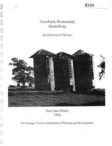
Booklet, Sera Jane Peters, Viewbank Homestead, Heidelberg: an historical survey, by Sera Jane Peters for Heritage Victoria, Department of Planning and Development, 1996
History of the Viewbank Homestead, originally a 90 acre site with homestead and outbuildings, now demolished.Black and white photocopy of typescript, with photographs, plans, reproductions of documents. 25 p plus 17 p of Appendices, unboundviewbank homestead, heritage victoria -
 Mission to Seafarers Victoria
Artwork, other - Art installation, Dagmar Udhe, Leap of the Heart: Ultramarine perspex oval shape by Dagmar Udhe, 1998
See document 1507Information for the brochure (http://www.artdes.monash.edu.au/globe/issue8/tbtitle.html) Construction in Process VI The Bridge, Melbourne Event: March 21-31 1998 Exhibition April 1-30 1998 During Construction in Process (CIP) III at Lodz, Poland in 1991, Emmett Williams and other participating artists initiated the idea of a biannual "performance" of their project in different cities and sites around the world. In the first instance, CIP was a response to the strictures of museum contained commodification of art practices and the dissolution of communism. And with this agenda in mind, their events affirm the active participation of international artists with local infrastructure and site specific materials. The organisation of the 1998 CIP in Melbourne, titled "The Bridge", took Richard Thomas, Katherine Armstrong, Gail Davidson and the legion of others over two years of dedication. And they brought off one of the most open-ended, logistically challenging conceptual events this metropolis has witnessed. The following photo essay provides a personal survey of the "The Bridge", as I saw it transpire around me. German artist Dagmar Udhe created several art installation in Swanson Dock and the Mission. This plaque was placed either in the dome or outside the dome. It may have been forgotten or left intentionally by the artist.PerformanceUltramarine ovoid shaped perspex plaque attached to the wall in the entrance of the Mission (Flinders Street).art installation, dagmar udhe, cultural events, artwork-paintings -
 Greensborough Historical Society
Map, Melbourne and Metropolitan Board of Works. Survey Division, MMBW, Yarra 2500 / 12.20. Watsonia Railway Station and environs, 1983_03
Melbourne and Metropolitan Board of Works. Yarra 2500 [base map]. 12-20, Parishes of Keelbundora 2856, Municipalities of Diamond Valley 257 and 228. Shows street names, easement sizes, lot numbers, lodged plan numbers, names of prominent features, contour values, creek or river names. Watsonia Railway Station and environs. Prominent streets: Watsonia Road, Elder Street, Morwell Avenue and Nepean Street. Includes former Watsonia Technical School and Gresswell Rehabilitation Centre sites.MMBW Map in 1:2500 [scale] series. Cream parchment with green tape reinforcing on edges and punched holes on left edge.mmbw, melbourne and metropolitan board of works, shire of diamond valley, watsonia - maps -
 Greensborough Historical Society
Map, Melbourne and Metropolitan Board of Works. Survey Division, MMBW, Yarra 2500 / 12.22. Watsonia North, 1978_03
Melbourne and Metropolitan Board of Works. Yarra 2500 [base map]. 12-22, Parishes of Keelbundora 2856, Municipalities of Whittlesea 239 and Diamond Valley 257. Shows street names, easement sizes, lot numbers, lodged plan numbers, names of prominent features, contour values, creek or river names. Watsonia Railway Station and environs. Prominent streets: Edmund Rice Parade and Macorna Street. Includes Christian Brothers Edmund Rice College and Janefield Special School sites and "proposed future freeway" (now Metropolitan Ring Road).MMBW Map in 1:2500 [scale] series. Cream parchment with green tape reinforcing on edges and punched holes on left edge.mmbw, melbourne and metropolitan board of works, shire of diamond valley, watsonia - maps, bundoora - maps -
 Greensborough Historical Society
Map, Melbourne and Metropolitan Board of Works. Survey Division, MMBW, Yarra 2500 / 14.22. St Helena, St Katherine's Church, 1979_08
Melbourne and Metropolitan Board of Works. Yarra 2500 [base map] 14.22. St Helena, St Katherine's Church. Parish of Nillumbik 3310. Municipality of Diamond Valley 257. Prominent streets St Helena Road, Weidlich Road, Yan Yean Road and Allumba Drive. Features include St Katherine's Church of England and the St Helena Secondary College site.MMBW Map in 1:2500 [scale] series. Cream parchment with green tape reinforcing on edges and punched holes on left edge.mmbw, melbourne and metropolitan board of works, shire of diamond valley, st helena - maps, st katherines church st helena -
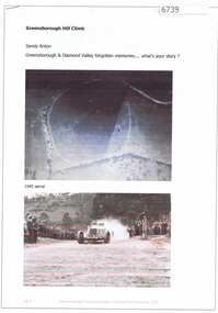 Greensborough Historical Society
Article and Photograph, Greensborough Hill Climb, 2017_
Information and photos about the Greensborough Hill Climb included a copy of the 1945 aerial survey showing the track.This photograph and text was copied from a Facebook site. Members are people who lived in the Greensborough area and share their reminiscences of the area with others. The site is administered by a GHS member but is not officially affiliated with the Society. Any information is the opinion of the contributor. Article and photograph sourced from social media.greensborough hill climb 1945, bill halliburton -
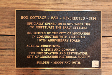 City of Moorabbin Historical Society (Operating the Box Cottage Museum)
Plaque, Official Opening Reconstruction Box Cottage 1984, 1984
The original small, pioneer cottage was built in the late 1840s to early1850s, by an unknown pioneer. It was located on part of a 30 Acre allotment that was originally part of Dendy’s Special Survey granted in 1841. The doors and window sashes, (made of red deal joinery timber), as well as the brass locks and fittings, are from the original cottage, and were imported from England. The fire-place bricks are from the original cottage, and are sun-dried, (not kiln fired), and are hand-made. Convict marks can be seen on two bricks. There is a small display of external cladding shingles from the original pioneer cottage. These shingles were hand-split, and most likely made from locally collected timber The nails included in this display were used to fasten the shingles on the original cottage, and are also hand-made. The enamel nameplate, “Colonial”, on the wall of the cottage, was the name chosen for the original pioneer cottage when Mr August Reitman, a sculptor, began leasing the property in 1917. August purchased the property c 1935, for 1200 Pounds approximately and resided there until 1953. He sold it to Lewis Timber Co Pty Ltd in 1970. In 1974 Mr Lewis, a timber specialist, found the dilapidated building on the property he had recently purchased in Jasper Rd and suggested it be reconstructed and relocated. Moorabbin City Council agreed and the cottage was rebuilt about 250 metres from its original site. The cost of the rebuild was met by 'Victoria's 150th Committee, plus a small grant from the City of Moorabbin, and Mr Laurie Lewis donated much of the timber for the reconstruction. CMHS volunteer members operate the Box Cottage Museum which is open to the public on the last Sunday of the month or by appointment. the Official Opening of the Reconstructed Box Cottage on November 18th 1984A plaque commemorating the Official Opening of the Reconstructed Box Cottage on November 18th 1984BOX COTTAGE - 1850 - RE-ERECTED - 1984box william, box elizabeth avis, deny's special survey 1841, brighton, moorabbin, ormond bentleigh, mckinnon, market gardeners, pioneers, early settlers, reitman august, reitman william, lewis timber co pty ltd, moorabbin city council 1934 – 1994, -
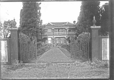 City of Moorabbin Historical Society (Operating the Box Cottage Museum)
Photograph - 3 black & white Photographs, 'The Grange' ( 'Baydon Hill' ) Moorabbin, c 1920
'The Grange ' was a 2 storey home built 1857 by Mr Charles Tuck, originally named 'Baydon Hill' , at 1011 Nepean Highway, Moorabbin ( South Brighton). Mr Charles Tuck was Veterinary Surgeon from Baydon Hill, Wiltshire, England, who migrated to Australia c1850. He married his cousin Miss Jan Chaudler in Melbourne in1853. He was at the Ballarat gold-fields at the time of the riots and then they settled in South Brighton ( later Moorabbin) and built a large Georgian Styled home called 'Baydon Hill'. The Tucks had a large family - 9 children. Charles enjoyed a prosperous Veterinary Practice as his advice was needed for stock purchases by the farmers / settlers. Charles died in 1893 and Jane left the property c 1903 and died at Blackburn in 1928. The House had 5 owners, the last being the Healey family c1920 and at some stage the name was changed to 'The Grange' and the gates shown were installed. The Healey Family were also prosperous in developing vegetables and flower seeds and seedlings. 'The Grange' was sold to Moorabbin City Council 1972 and then used by the City of Moorabbin Historical Society for meetings and storage of historical material. It was demolished amidst considerable controversy 1983 and the District Police Offices were built on the site. ( S.T.Mulvany, Grand-daughter of Charles Tuck 26/7/1974)The Grange was a significant property 1853 -1983 in Moorabbin. It was built by Mr Charles Tuck 1857and in1900 extended from Point Nepean Road to South Road - 10acres. Mr Harold James Healey purchased the property in c1920 and leased a portion to a Chinese market gardener. Later with his sons he established a profitable Plant Nursery that they managed for 42years.. Keith Healey, a son, remodelled the house extensively mid 20thC .The Moorabbin City Council purchased it in 1972 for $255,000 and it was demolished amid controversy 1983. The District Police Offices are now on the site.3x black and white photographs of the property at 1011 Nepean Highway Moorabbin built by Mr Charles Tuck c1853 known as 'The Grange'. Originally it was named 'Baydon Hill' because he migrated from Baydon Hill, Wiltshire, England c1850. These photographs are c 1880, 1920 and 1950 showing the original and later additions made to the property by some of the 5 owners.Written in pencil on back a) " This Photo donated by Mr Neil Follett - at the time it came into his possession he had a photography studio in Cheltenham. Photographer unknown"; Folio 6 b) The Grange c 1950 Folio 6/10 c) 'Baydon Hill' ( alias "The Grange" ) / Donated by Mrs Elsa Jones, daughter of Leslie Stephen Tuck, youngest son of Charles Tuck Folio 6 /18tuck charles, tuck jane, veterinary surgeons, livestock, market gardeners, early settlers, dendy's special survey, brighton, moorabbin, ballarat, gold diggings, horses, chickens, cattle, bullocks, flower shows, fruit garden, mulvaney s. t., healey haold james, healey keith, moorabbin city council, chinese market gardeners, plant nursery, tuck leslie stephen, jones elsa -
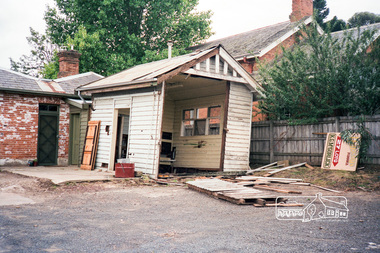
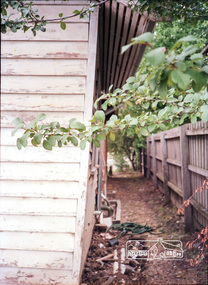
 Eltham District Historical Society Inc
Photograph, The former Police residence at 728 Main Road under renovation work for future Shire of Eltham use, c.Nov. 1991
The original Eltham Police Station was used up till about 1960. The building was then taken over and used by the Vermin and Noxious weeds Destruction Section of the Department of Crown Lands and Survey. They vacated the building c.March 1981 and it remained unoccupied for a period of time whilst its future was discussed in Council. About 1986 the Shire took over use of the Police Residence and renovated it for use by the Shire Parks and Environment Office. The original Police Station was termite infested and was removed. It was later replaced by a replica building which was used as a lunchroom for Council employees working at the site. Based on photos contained in the 1992 Bick Heritage Study of the Police Residence and Stable, this roll of film was taken Nov 1991.Roll of 35mm colour negative film, 7 stripsKodak GA 100 5095shire of eltham, justice precinct, police residence, police station, local history centre -
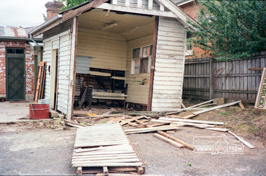
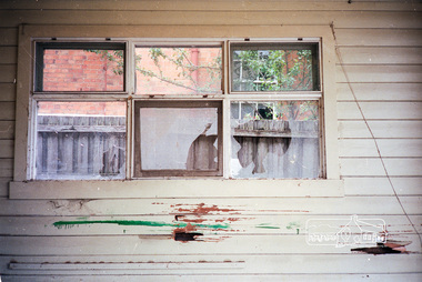
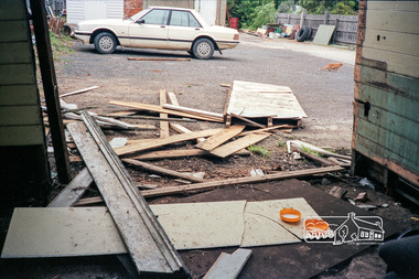
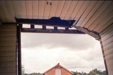
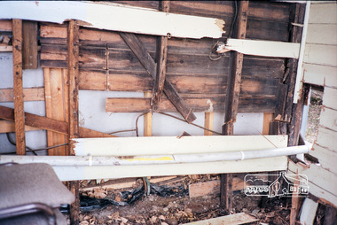
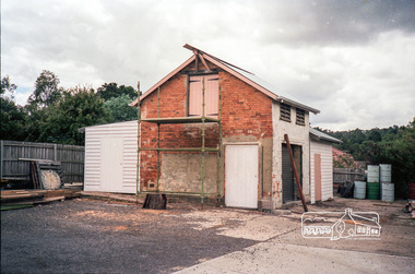
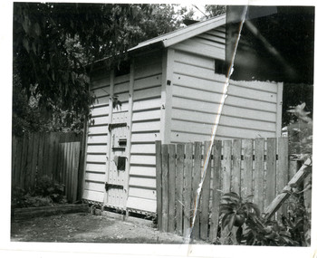
 Eltham District Historical Society Inc
Photograph, The original Police Stables at 728 Main Road under renovation work for future Shire of Eltham use, c.Nov. 1991
The original Eltham Police Station was used up till about 1960. The building was then taken over and used by the Vermin and Noxious weeds Destruction Section of the Department of Crown Lands and Survey. They vacated the building c.March 1981 and it remained unoccupied for a period of time whilst its future was discussed in Council. About 1986 the Shire took over use of the Police Residence and renovated it for use by the Shire Parks and Environment Office. The original Police Station was termite infested and was removed. It was later replaced by a replica building which was used as a lunchroom for Council employees working at the site. Based on photos contained in the 1992 Bick Heritage Study of the Police Residence and Stable, this roll of film was taken Nov 1991.Roll of 35mm colour negative film, 7 stripsKodak GA 100 5095shire of eltham, justice precinct, police residence, police station, local history centre -
 Kiewa Valley Historical Society
Papers photocopied - photo, list of names, Kiewa Valley Pioneers and Early Activities on the Bogong High Plains
All Early History of the Kiewa Valley. 1. Photo clear but no date. Men named and are residents selecting a site for a bridge at Keegans Crossing 2. Department of Crown Lands letter - 1841 Tawonga pastoral run - Mr James Roberts and Mullindollingong pastoral run 1846 - Mr Patrick Reynolds 3. An account of the Bogong High Plains by W. F. Waters from the late 1890s to 1930s. Published article in the Schuss magazine. August 1958 History of Keegan's Crossing, Kiewa Valley and surrounding residents with names and photos. Early pastoral runs in the Kiewa Valley and Early activities on the Bogong High Plalns..1.The photo includes a listing of residents selecting a site for a bridge at Keegans Crossing. 2. A letter from the Department of Victorian Lands and Survey re early settlers 3. History written in Schuss magaine, Aug. 1958. "In 1896 ... erection of snow poles from Rocky Valley to Tawonga Hut. keegan's crossing, w.f. waters, tawonga and mullindollongong pastoral runs -
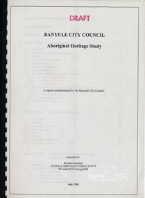 Eltham District Historical Society Inc
Book, Banyule City Council Aboriginal Heritage Study prepared by Austral Heritage Consultants, 1998 July
A draft report on the pre-European Aboriginal achaeological sites in the city of Banyule, including results of previous field surveys; Banyule covers a small part of the former lands of the Woi Wurrung. The report discusses heritage overlay, planning issues and the proposed Victorian planning provisions.100p, 30 cm.Marked "Draft"aboriginal heritage banyule, woi wurrung -
 Victoria Police Museum
Police Stations (Apollo Bay)
Apollo Bay is a coastal town in southwestern Victoria. It is situated on the eastern side of Cape Otway, along the edge of the Barham River and on the Great Ocean Road, in the Colac Otway Shire. The original township was surveyed in 1853 and named Middleton. In 1881 the town was renamed Krambruk which was changed to Apollo Bay in 1898. The Krambruk Police Station was opened on 7 March 1888 in the Southern District on land opposite the site of the current Mechanics' Institute and changed its name to the Apollo Bay Police Station on 1 September 1990. It came under the Barwon District in 1948 and "Lima" Western District from 4 March 1990. In 1930 the police station was located to 29 Nelson Street. It was a seven-roomed weather-board dwelling on three-quarters of an acre of land. It consisted of six rooms of pine, lined and painted; one pantry; one bathroom and wash-house; one hall; one office and one W.C.. There was stabling for one horse and one cell for prisoners. It was staffed by one Mounted Constable. In the early 1970s land was acquired at 31 Nelson Street and a new police station was constructed. This was a three-roomed brick building with a cell block at the rear. By the time it closed in 2005 it had been extended twice. On 17 November 2006 the current Apollo Bay Police Station opened in its current location at 35a Nelson Street, on the corner of Cartwight Street). Outside the peak summer season, the station is open 16 hours per day and staffed by one sergeant and five other members. 3 black & white photos and 2 coloured photospolice stations; apollo bay police station -
 Eltham District Historical Society Inc
Photograph, Tom Prior, Police Station and Residence, Maria Street, Eltham, c.1900
Situated near the top of what was known as 'Policeman's Hill' according to Miss Ivy Reynolds, neice of the photographer, Tom Prior. From the left, Eltham Court House, Police Residence and Police station on Main Road and corner of Brougham Street. These buildings formed part of Little Eltham and still stand (without the front fence) today though the Police Station was demolished in 1986 due to termite damage. A replica was built circa 1989. The institutions of law and order in Colonial Victoria included the police, courts and prisons. The 1852 report of the Snodgrass Select Committee appointed to "identify the policing needs of the colony” noted there existed seven independent police forces that did not co-operate or regularly communicate. Following the committee's report all these police entities were merged into the Victoria Police, founded on 8 January 1853, to implement law and order responsibilities throughout the Colony of Victoria. The Eltham Courthouse (1860) and adjacent Police Residence (1859) formed a justice precinct established in the immediate aftermath of the 1852 police inquiry and the effects of the gold rush. The physical presence of these buildings, in the centre of the early Eltham township, defined centralised control over law and order. In the early days the Police Constable in charge would conduct his duties travelling around the district by horse; a stable was located at the rear of the residence. At times the horse would be grazed on the paddocks across the road. Horseshoes were forged by the blacksmith beside the Courthouse on the high side of “Policeman’s Hill”. Along with the stable, there was a two-cell bluestone lockup where prisoners were held awaiting trial in the adjacent Courthouse. Their meals were usually provided by the policeman’s wife or from the hotel just up the road. With the arrival of the railway in 1902 the town centre gradually shifted towards the railway station. The Police Station and operations were moved into the town centre in 1961 to a renovated house in Pryor Street, which was later replaced by the current Police Station. From 1961-1981 the residence was occupied by the Vermin and Noxious Weeds Destruction Section of the Department of Crown Lands and Survey. Prior to August 1967 the former Police Station was dragged to the rear of Police Residence to make way for the construction of a driveway and access from Main Road. The building was placed on the site of a former Scullery and modified for Lands Department use. In 1981 the Shire of Eltham took over management of the former Police Residence in Eltham. It remained unoccupied for a period whilst its future was discussed in Council. It was then used for a community job creation scheme until 1985. In 1985 the Shire of Eltham Parks and Environment occupied the residence. Council improved the driveway but later added a second rear access from Brougham Street due to the dangerous nature of the Main Road entrance. Additionally, a rear toilet facility between the Police Residence and the relocated former Police Station, which was doubling up as a lunchroom. Council also commenced discussions to re-establish a replica Police Station. Around November 1986 the former Police Station was demolished; believed to have been suffering termite damage. About 1989, after some years of discussion, a replica Police Station was built, based on photographs, to act as a lunchroom and meeting room for the Parks and Environment staff and volunteers doing community service. In 1996 Eltham District Historical Society held discussions with Nillumbik Shire Council commissioners throughout the year regarding a home for the Society. A proposal was put forward by the Society in October to occupy the former Police Residence. In March 1997 Eltham District Historical Society gained access to former Police Residence and on July 12, 1998, moved into its Local History Centre. In July 2018, Eltham District Historical Society gained access to the replica Police Station (which had been used as a music library and storage for the Eltham Concert Band) for use as part of regular heritage tours for schools and community-based groups.This photo forms part of a collection of photographs gathered by the Shire of Eltham for their centenary project book,"Pioneers and Painters: 100 years of the Shire of Eltham" by Alan Marshall (1971). The collection of over 500 images is held in partnership between Eltham District Historical Society and Yarra Plenty Regional Library (Eltham Library) and is now formally known as 'The Shire of Eltham Pioneers Photograph Collection.' It is significant in being the first community sourced collection representing the places and people of the Shire's first one hundred years. The Reynolds family were early settlers in Research. The Reynolds/ Prior collection of photographs were taken by Tom Prior, the maternal uncle of Ivy Reynolds, around 1900 and the 60 photos in the album give a fine overview of many of the landmarks of Research and Eltham over 100 years ago. lvy lived in the family home for many years at 106 Thompson Cres Research. Ivy's father, Ernst Richard Reynolds and grandfather, Richard Reynolds, lived at the same address. Ivy's father Richard worked for Mr. Trail on his property in Research. Reynolds Road is named after the family. Mr Tom Prior (wife Eva) worked at the Melbourne zoo. He was very innovative and made his own camera, using the black cloth hood to exclude the light. The photographs are a reminder of the rural nature of Research and Eltham and its rich heritage.Digital imagechildren, court house, courthouse, eltham, eltham district historical society, eltham justice precinct, little eltham, local history centre, main road, police residence, police station, reynolds prior collection, sepp, shadow, shire of eltham pioneers photograph collection -
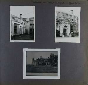 Glen Eira Historical Society
Album - Album page, Helenslea now Shelford CEGGS, Hood Crescent, Circa 1972
This photograph is part of the Caulfield Historical Album 1972. This album was created in approximately 1972 as part of a project by the Caulfield Historical Society to assist in identifying buildings worthy of preservation. The album is related to a Survey the Caulfield Historical Society developed in collaboration with the National Trust of Australia (Victoria) and Caulfield City Council to identify historic buildings within the City of Caulfield that warranted the protection of a National Trust Classification. Principal photographer thought to be Trevor Hart, member of Caulfield Historical Society. Most photographs were taken between 1966-1972 with a small number of photographs being older and from unknown sources. All photographs are black and white except where stated, with 386 photographs over 198 pages. The mansion has been the site of Shelford Church of England Girls’ Grammar School - now Shelford Girls’ Grammar School - since circa 1922.From Victorian Heritage Database citation for HO115: "Helenslea" 3 Hood Crescent, Caulfield North https://vhd.heritagecouncil.vic.gov.au/places/35212 as at 21/10/2020 ''Helenslea'' was built for Sir George Stephen, MLA, barrister and mining investor by 1863. It was built with an address to Glen Eira Road with the driveway gates close by the present Helenslea Road corner. The present address is no. 3 Hood Crescent, Caulfield North. It is historically, aesthetically and socially significant. It is historically significant (Criterion A) as the home of Sir George Stephen, MLA for Collingwood, barrister and mining investor and for its capacity to demonstrate Caulfield's early attraction as a residential retreat for Melbourne's eminent citizens. It is aesthetically significant (Criterion E) as a villa residence characteristic of the mid Victorian period, predating the use of cast iron and comparing in this respect with Charles Webb's "Farleigh" (1865) at 6 Farleigh Grove, Brighton. Its substantial nature causes it to be the earliest surviving mansion house in the Municipality. The porch, external austerity and opulent entrance hall and staircase are important contributory elements whilst the survival of the exterior surfaces predominantly in an unpainted state enhances its level of integrity. It is socially significant (Criterion G) for its association with Shelford C.E.G.G.S. since 1922. Page 86 of Photograph Album with three photographs (two portrait and one landscape ) of different views of Helenslea. One is a photo of a photograph.Handwritten: "Helenslea" now C.E.G.G.S Hood Cres [top right] / third photo is of a photograph titled "Shelford" / 86 [bottom right]trevor hart, hood crescent, helenslea, c.e.g.g.s., school, 1860's, sir george stephen, unpainted, mansion, shelford, villa residence, mid victorian, glen eira road, helenslea road, ceggs, porches, stairs, caulfield north, entrances, shelford church of england girls' grammar school, shelford girl's grammar, ivy -covered walls, caulfield