Showing 134 items matching "survey reserve"
-
 Whitehorse Historical Society Inc.
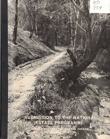
Document, Submission to the National Estate Programme, ca 1974
Submission to the National Estate Programme: Schwerkolt Cottage, Yarran Dheran and associated areas, City of Nunawading, 1974?.Submission to the National Estate Programme: Schwerkolt Cottage, Yarran Dheran and associated areas, City of Nunawading, 1974?. Includes 'Report on the survey of the vascular flora of the Yarran Dheran Reserve, by A.B. Court.Submission to the National Estate Programme: Schwerkolt Cottage, Yarran Dheran and associated areas, City of Nunawading, 1974?.city of nunawading, parks and reserves, schwerkolt cottage, yarran dheran, webster, noel, court, a.b., native plants -
 Rutherglen Historical Society
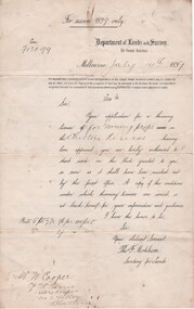
Document - License to thin trees, 1899 (Exact)
Dated July 14th 1899. Sent to Mr W. Cooper / c/o Mr Barrie / Storekeeper / No. 2 Valley / Chiltern / "Copy of Land Act 1896 / Regulations. Chapter XI Thinning Licenses"Document on stiff paper. Letter to Mr W. Cooper granting license to thin trees on a block of land at Chiltern Reserve. On back, copy of Land Act Regulations 1890"Department of Lands and Survey. On Forest Business"license, timber felling, cooper family, forestry, chiltern reserve -
 Ballarat Heritage Services
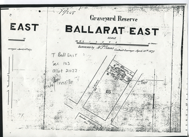
Digital photograph, Graveyard Reserve, Ballarat East
Ballarat East, Section 103, Allotment 21 & 22, Peake and Tress Streets, Mount Pleasant. Surveyed by W. S. Reeves Contract Surveyor April 14th, 1871. Also shows allotments of T. Williams and F. Macalpin, as well as the Powder Magazine Reserve.Plan of the Graveyard Reserve and Mount Pleasant Powder Magazine.mount pleasant, w.s. reeves, plan, powder magazine, t. williams, f. macalpin -
 Ballarat Heritage Services
Document - Report, McDougall and Vines Conservation and Heritage Consultants, Sturt Street Gardens, Ballarat, Victoria Conservation and Landscape Management Plan, 2007, 07/2007
Ballarat's Sturt Street has its origins in W.S. Urquhart's survey of 1851. A generous reserve was allocated for the main streets of Ballarat, of which Sturt Street was the first. In the 1860s Sturt Street was planted with blue gums, with a dual carriageway and central median strip installed. Bandstands ere soone erected, including the Queen Alexandra Bandstand (1908) and the Titanic Memoria Bandsatnd (1915).PDF of a report on the Sturt Street Gardens, Ballarat.sturt street ballarat, conservation management plan, sturt street gardens, landscape management plan, statue, gardens, bandstands, infrastructure, city of ballarat report -
 Ballarat Tramway Museum
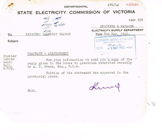
Administrative record - Memorandum, State Electricity Commission of Victoria (SECV), "Question to be asked without notice by A. T Evans Esq MLA in the Legislative Assembly on 2nd May 1962", May. 1962
Memorandum and a copy of a report concerning a "Question to be asked without notice by A. T Evans Esq MLA in the Legislative Assembly on 2nd May 1962". All with rounded corners. .1 - Memo dated SEC paper typed, sending to Ballarat a copy of the Question and response. .2 - Copy of the question and response on heat sensitive paper, concerning the suggestion of the AETA to use in Ballarat trams ex Footscray and that the State does an independent survey prior to any potential closure of the Ballarat system. Response from The Minister, responding to the suggestion, trams unsuitable, economics, and that a bus service to the satisfaction of the TRB is proposed.trams, tramways, closure, letters, aeta, footscray, parliament -
 Ballarat Tramway Museum
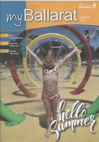
Magazine, City of Ballaarat, "my Ballarat - Summer 2016", Jan. 2017
Magazine - 40 pages, centre stapled, full colour printed on white paper, titled "my Ballarat - Summer 2016", providing news, events, activities for the City of Ballarat. Includes the results of the Lake Wendouree Master Plan Survey - includes the expansion of the Ballarat Tram depot for the joint BTM - RSL Ballarat Sub-branch - Tramway and Military Interpretative Centretrams, tramways, btm, rsl, masterplan, lake wendouree, botanical gardens -
 Ballarat Tramway Museum
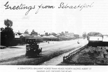
Book, E.D. Jenkins and Lloyd Jenkins, "Sebastopol Victoria - A Historical Survey of Early Sebastopol - 1864- 1964", 1989
Book - 92 pages plus card covers, a historical survey of the Sebastopol district. Originally written by E.D. Jenkins for the Borough of Sebastopol's centenary in 1964, reprinted with additional text by Lloyd Jenkins to recognise the 125th anniversary of the Borough covering the years 1965 to 1989. Book covers mining history, churches, the Borough Council, early days of the district and various points, eg cabmen, horse trams and electric trams, schools, the Mechanics Institute, various clubs, fire brigade, hotels, industries, and programme of events to celebrate the centenary. The second part of the book, covering the period is laid out in a chronological order with forward by Cr. Donald, the Mayor with many photographs. Centre page has a large map of the district showing the many mines, leads, roads and other historic locations. Tramway photos are horse tram No. 7, ESCo 17 at depot (all on file) and a photo showing a horse tram heading north along Albert St. with the shopping centre in the background - see image. Photo taken just after the tram has crossed the roadway. Copy of the horse tram heading north along Albert St. made Oct. 2001 for the "gold, Gold GOLD" temporary exhibition - colour laser print onto card, with Velcro dots on rear. Stored in box D1 (Display Box) 02/2003. See Reg Item 3883 for another print of this photograph.On page 3 in black ink "Ballarat Tramway Museum Inc. With compliments, D.L. Jenkins 14/4/1999"trams, tramways, sebastopol, local history, public transport, mining, horse trams, esco -
Ballarat Tramway Museum
Newspaper, Angela Carey, "Support for trams - Visitors like the idea but residents shy at the cost.", 9/01/1997 12:00:00 AM
Item written by Angela Carey in The Courier, Ballarat, page 1 on 9/1/1997 reporting on a survey by the Courier the previous day. Response to the question "Do you think Ballarat City Council should spend money to bring trams back to Ballarat?" Yes - 71%, No - 24% and unsure - 3%. Gives a breakdown between residents and visitors and general comments.feasibility study, ballarat city tramway, ballarat revival, surveys -
 Ballarat Tramway Museum
Newspaper, The Courier Ballarat, "Trams: 67% Say Yes", "Put tram plan to the vote", "Lets make sure we all get on the right tram", "Trams would be bad for mall: manager", 13/07/2002 12:00:00 AM
Set of four cuttings from The Courier, Ballarat dated Saturday 13/7/2002 regarding the reintroduction of trams to Ballarat. 2239.1 - Front page with caption "Trams: 67% Say Yes", written by Alex Easton regarding a survey of 312 residents by the Courier. Also has a photo by Jeremy Bannister of former tram driver Alan Jeffreys at the controls of a tram in Wendouree Parade with Roger Salen in the background. 2239.2 - page 9 - Editorial written by Stuart Howie titled "Lets make sure we all get on the right tram" discussing the positive and negative attributes and problems of spending a large amount of money to return trams to Ballarat. Has a digitally composed photo of No. 13 in Lydiard St. North, showing destination "CITY" and a photo of the Eureka Stockade. 2239.3 - Page 4 - lead article titled "Trams would be bad for mall: manager", written by Alex Easton quoting David Nolan and the impact of trams on the mall, along with a cartoon about a tram ticketing machine being out of order. Cartoon by inkcinct. Also continues from page 1, lead article. Notes that readers can have they say on a web poll. 2239.4 - Page 8 - Letter to the Editor, by William J Hoath titled "Put tram plan to the vote", asking for any tram proposal to be put to the vote of ratepayers. Also on the side in a column titled "Short Takes", titled "Link lake to the tram line", provided by Joan C. Ryan of Ballarat.ballarat revival, letter to the editor, ballarat city tramway, lydiard st. nth -
 Ballarat Tramway Museum
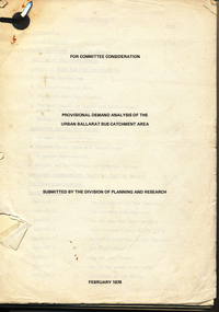
Document - Report, Tramway Museum Society of Victoria (TMSV), "Provisional Demand Analysis of the Urban Ballarat Bus Catchment Area", Feb. 1978
67 page document on the results of surveys done on Ballarat passenger services in late 1977 and early 1978, dated 2/78. Has survey forms, procedures, questionnaire, results etc. Table of contents, appendices. Printed onto duplicating paper. Single metal paper fastener in top left hand corner.trams, tramways, ballarat, bus services, surveys -
 Ballarat Tramway Museum
Document - Form/s, Ballarat Tramway Preservation Society (BTPS), "Ballarat Tourist Tramway Passenger Survey", 1975
Duplicated sheet of foolscap paper, titled "Ballarat Tourist Tramway Passenger Survey", - form. Has two forms per sheet - layout different, but questions the same. Used 1975. Asks 15 questions.trams, tramways, btps, forms, surveys -
 Ballarat Tramway Museum
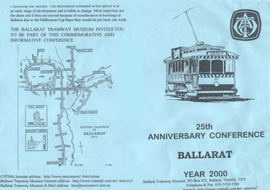
Pamphlet - flyer, Ballarat Tramway Museum (BTM), "25th Anniversary Conference Ballarat Year 2000", 1998
Produced to promote the COTMA 2000 conference.Pamphlet or form advertising the BTM's COTMA Conference for 2000 - "25th Anniversary Conference Ballarat Year 2000", consisting of a folded A4 blue photocopied sheet and a single sheet of paper as a survey form with 11 questions. Has tram 33 as the logo on the front cover and map of the Ballarat tramways in 1971. Distributed at the 1998 Christchurch Conference. Two copies held.trams, tramways, cotma, conferences, btm, 25th anniversary -
 Ballarat Tramway Museum
Ephemera, Arnall & Jackson, Ballarat tram timetables, 1972
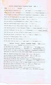
Green cloth covered cardboard covers, sewn sections field or survey notebook, with end papers, made by Arnall & Jackson of Brunswick - their No. 641. Use by the BTPS - W. Doubleday and Bill Kingsley - for survey notes during the construction of the BTPS depot access track 1972 and 1977 , including pole survey and other notes. Gives levels around the depot. Full scan of document added as a pdf file 5/6/2019.trams, tramways, btps, surveys, depot, access track -
 Ballarat Tramway Museum
Map, Australian Survey Corps, "Victoria Ballan", 1933
Topographic map of the Ballan area - includes Bacchus Marsh and Bungaree, No. 837, Zone 7, Army Map, dated 1933, 1:63360. Shows rail lines, roads, elevations, contours. Collected with relevance to the Museum's association with the area, at Bungareetrams, tramways, bungaree, map -
 Bendigo Historical Society Inc.
Map - MARKS COLLECTION: MAP SANDHURST 1867
Original map: Sandhurst 1867, shows central Bendigo and surrounds, including police camp, stockade, 'old cemetery', reserve for. On bottom of map: 'Lithographed at the Department of Lands and Survey by D. Henderson, 20 February, 1867'. On top RH corner 'Sheet No 1 Sandhurst'.map, bendigo, 1867 sandhurst map -
 Bendigo Historical Society Inc.
Document - PETER ELLIS COLLECTION: LETTER, 4th October, 1976
Letter, dated 4/10/1976 from Diana R. Collier, Hon. Secretary, The Bendigo Field Naturalists Club to The Minister for Lands, The Hon. W. A. Borthwick making an application to have a reserved area for the preservation of native flora and fauna near the Quarry Hill Golf Club. Features, fauna and flora are mentioned including an original Boundary Stone and the Fairy Waxflower (Eriostemon verrucosus) also known as the Bendigo Wax Flower. Included is a list of birds (including some that nest in the area sometimes) and plants.communication, postal, letters, peter ellis collection, the bendigo field naturalists club, proposed boyd st nature reserve, the hon w a borthwick, recreation reserve extension (rs 3458), cemetry reserve extension (rs 3777), rubbish depot (rs 5980), education purposes reserve, (rs 6402), j willis, bendigo city council, city boundary stone, regel, quarry hill golf club, canberra botanical gardens, stony ridge flora reserve sydney, kings park perth, maranoa gardens melbourne, kaweka sanctuary castlemaine, central and northern branch of the national trust, school sanctuary (quarry hill), education dept, society for growing australian plants - bendigo group, lawn cemetery, bendigo city council parks and recreation dept, bendigo trust afforestation committee, quality of life action group, ackhurst plan, winifred waddell estate, dept of crown lands and survey, ministry for conservation, mr g edwards, mr m goode, mr j chellacombe, diana r collier -
 Bayside Gallery - Bayside City Council Art & Heritage Collection
Map, H.B. Foot, Plan of the Brighton Estate containing 5120 acres, first special survey at Port Phillip, c. 1842
This plan records the Brighton Estate, also known as Dendy's Special Survey. In 1840 Henry Dendy, a farmer in Surrey, England acquired a "Special Survey" from the Commissioners for Land and Emigration which gave him the right to choose land in Port Phillip for the low price of £1 per acre for 5120 acres. Dendy appointed Jonathan Binns Were, as his agent, who later became a partner. Together, Dendy and Were decided on an area 5 miles south from Melbourne, bounded by North Road, East Boundary Road, South Road and to the west by Port Phillip Bay. Their Brighton Estate was first surveyed by T. S. Townsend in May 1841 and was re-surveyed by Robert Hoddle. Dendy and Were were making plans to sell the land and advertised a 30-guinea prize for the best subdivision which was to be divided into a village, marine residences, suburban and cultivation allotments, with the remainder being divided into country sections. The competition was won by H.B. Foot, who planned the village around a reserve and crescents and a 'green belt' forming the town boundary. brighton estate, dendy's special survey, special survey, henry dendy, jonathan binns were, w.b. were, survey, plan, map, brighton, george ward cole, baker's lithographer, hibernian, subdivision, town planning, cartographic material, h.b. foot -
 Bendigo Historical Society Inc.
Book - Aileen and John Ellison collection: Accent on Axedale
Axedale is a town in Victoria, Australia. It is located on the McIvor Highway, in the City of Greater Bendigo, east of Bendigo. It was surveyed and proclaimed in 1861. (Wikipedia)A thirty-six pages book detailing the history of Axedale. Published by the centenary and back to Axedale committee. Chapters on early settlement, churches, education, police, municipal affairs, commerce, cemeteries, racecourse reserve, the railway, Eppalock weir, the hall, the wars, C.W.A. camp sites, C.F.A. sport. Many photographs throughout. L.J. Ellisonaxedale, history -
 Bendigo Historical Society Inc.
Programme - THE BROOK AND ANDERSON FORTUNA COLLECTION: ATHLETIC SPORTS MEETING
LHQ Cartographic Company, Australian Survey Corps (OC Maj WM Sarll). Athletic sports meeting, Upper Reserve, Bendigo. Monday 31stJanuary 1944, first event at 12.45pm Eight pages listing all the events and the participants.military, world war 2 -
 Ballarat Tramway Museum
Photograph - Illustration/s, News and Information Bureau - Photo, Ballarat view from Town Hall, Oct. 1958
Yields information about the Sturt and Lydiard St streetscape from the Town Hall, c1958.Photograph of intersection of Sturt St and Lydiard St from Town Hall. Looking north east to Black Hill. See also item with Reg. No. 667 of similar but earlier view. Photo is inside cover of ANZ quarterly survey, dated Oct. 1958. Shows four trams in City Loop and good photo of trackwork and motor cars of period. Not to be displayed - before copy neg made.Ballarat - important Provincial Citytrams, tramways, sturt st, black hill, aerial views, trackwork -
 Kew Historical Society Inc
Plan, Melbourne & Metropolitan Board of Works : Borough of Kew : Detail Plan No.1296, 1904
The Melbourne and Metropolitan Board of Works (MMBW) plans were produced from the 1890s to the 1950s. They were crucial to the design and development of Melbourne's sewerage and drainage system. The plans, at a scale of 40 feet to 1 inch (1:480), provide a detailed historical record of Melbourne streetscapes and environmental features. Each plan covers one or two street blocks (roughly six streets), showing details of buildings, including garden layouts and ownership boundaries, and features such as laneways, drains, bridges, parks, municipal boundaries and other prominent landmarks as they existed at the time each plan was produced. (Source: State Library of Victoria)This plan forms part of a large group of MMBW plans and maps that was donated to the Society by the Mr Poulter, City Engineer of the City of Kew in 1989. Within this collection, thirty-five hand-coloured plans, backed with linen, are of statewide significance as they include annotations that provide details of construction materials used in buildings in the first decade of the 20th century as well as additional information about land ownership and usage. The copies in the Public Record Office Victoria and the State Library of Victoria are monochrome versions which do not denote building materials so that the maps in this collection are invaluable and unique tools for researchers and heritage consultants. A number of the plans are not held in the collection of the State Library of Victoria so they have the additional attribute of rarity.Original survey plan, issued by the MMBW to a contractor with responsibility for constructing sewers in the area identified on the plan within the Borough of Kew. The plan was at some stage hand-coloured, possibly by the contractor, but more likely by officers working in the Engineering Department of the Borough and later Town, then City of Kew. The hand-coloured sections of buildings on the plan were used to denote masonry or brick constructions (pink), weatherboard constructions (yellow), and public buildings (grey). This area was once known as O’Shaughnessy’s Paddock. O’Shaughnessy was the licensee of the Kew Hotel. The ‘Paddock’ or farm was for many years the closest farm to Melbourne. By 1903, when this plan was surveyed and lithographed, little of the farm remained. The area is dominated by a ‘clay hole’, on the site of the current Foley Reserve. It was used by Smart’s Brickyard from the 1880s until 1911, when the Council purchased it for a rubbish dump. It is notable as the site is one of the few industrial operations to have existed in Kew. By 1903, urban development was characterised by larger houses fronting Barkers Road and brick and weatherboard villas in Foley Street. Nearer the pit, weatherboard houses predominated. Foley Street bisected the triangular block and continued right to Denmark Street. At this stage, a house impeded the through road, only allowing access via a right of way to High Street.melbourne and metropolitan board of works, detail plans, mmbw 1296, cartography -
 University of Melbourne, Burnley Campus Archives
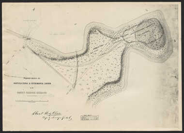
Photograph, Clement Hodgkinson, Proposed Reserve for Horticultural & Experimental Garden in the Survey Paddock, Richmond, 1862-1948
Photograph dated 7.12.48 of plan by Clement Hodgkinson, Deputy Surveyor General. Gazetted 1/8/62, handwritten on it in pencil.clement hodgkinson -
University of Melbourne, Burnley Campus Archives
Plan, [Historical Maps of Richmond Park], 1862-2000
... Boulevard Richmond melbourne richmond park survey paddock (1 ...(1) Proposed reserve for Horticultural & Experimental Garden in the Survey paddock Richmond. R.19A (1865). Shows Swan Street Extension. Gazettals 1877, 1887. (2) As (1). Half of map only Annotation by A. Purchas, 9 October, 1862. (3) Plan of Richmond park. A.L. Martin Authorised Surveyor, 31st August, 1872. [Dept. of lands & Survey Melbourne, J. Noone, 6th September 1872.] Map in 4 sheets. (4) Richmond Park. Surveyed by Geo. Black, Authorised Surveyor 13.8.91 (2 copies). (5) [Richmond Park] Shows road alignments gazetted 1871 & 1881 (part copy only - Neg. 18375). (6) City of Richmond Parish of Jika Jika County of Bourke. Department of lands & Survey, 1919 (annotations i.e. Melb. City Link, Amrad, etc. to 1994.) (7) Burnley gardens, 2000. Produced by P. Tulk, Institute of Land & Food Resources, Burnley College, 2000 (re area proposed for heritage listing.)richmond park, survey paddock -
University of Melbourne, Burnley Campus Archives
Map (item), Proposed Reserve for Horticultural & Experimental Garden in the Survey Paddock. Clement Hodgkinson Deputy Surveyor General, 1862
horticultural & experimental garden, survey paddock, clement hodgkinson -
 Friends of Ballarat Botanical Gardens History Group
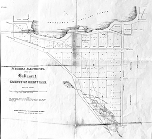
Work on paper - Suburban Allotments (west of) Ballaarat, Wendouree or Yuille's Swamp, County of Grenville 30/4/1856, 30/4/1856. No date given for photocopy
This map of the 1856 survey shows the numbered suburban allotments and the boundaries surrounding this area including Wendouree or Yuilles's Swamp close to where the Ballarat Botanical Gardens and the Lake exist today. This map gives a clear idea of an early survey of this western area and directions to areas of Ballarat surrounding these allotments.2 pages of the same map, except p.2 shows the Township Reserve on the lefthand side of the page. On the back of p.2, righthand corner is the Public Records Stamp.P2, righthand corner is the citation in pencil.john garner, doctor john garner, ballarat botanical gardens, friends of ballarat botanical gardens, map of western suburban allotments 1856, county of grenville, public record office of victoria, john garner collection, gardens, ballarat -
 Truganina Explosives Reserve Preservation Society Inc (TERPS)
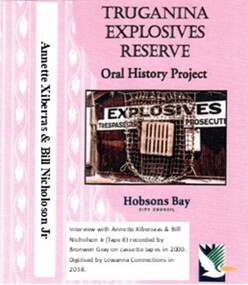
Digitised Oral History – Truganina Explosives Reserve - Tape 8 Annette Xibarras and Bill Nicholson Jnr, 2018
The interviews were recorded in 2000 by Bronwen Gray and Alan Young for the production of Unreserved, Stories from Truganina Explosives Reserve, animated stories from past residents, workers and interested people of the Reserve (subject to copyright 2004). Annette Xibarras and Bill Nicholson Jnr discuss the indigenous significance of the Truganina Explosives Reserve. At the time of the interview Annette was the manager of the Kulin Nations Cultural Heritage Organisation. Bill, a Wurundjeri Elder, was a Wurundjeri Cultural Officer. They discussed their childhood, aboriginal customs, connection with the land and the locating of aboriginal remains at the Museum of Victoria and the re-burial at the site where they were found. A primary source of information on memories of the Truganina Explosives Reserve and Altona,VictoriaDigital copy of original cassette recorded in 2000 and digitised in 2018julia jones, princess balam balam, archaeological survey, middens, wurundjeri, kulin nations, coranderrk, braybrook, sacred sites, mt william, bunurong, museum victoria, altona, martha nicholson -
 Parks Victoria - Cape Nelson Lightstation
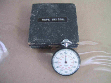
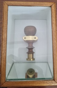
Instrument - Watch, stop
The date of manufacture and age are unknown. It is believed to be original to the lightstation. Of six Victorian lightstation collections surveyed, Cape Nelson is the only one with a stop‐watch. The watch is significant as an intact and relatively uncommon object remaining at a Victorian lightstation and has first level contributory importance for its historical values.The circular, top‐winding metal stop‐watch has an associated blue velvet‐lined, square case. The watch bears an inscription but the date of manufacture and age are unknown. It is believed to be original to the lightstation. The watch bears an inscription etched into the back." C. of A. / C.L.S. /^ / No 101" and on a sticker "C of A / D.O.T. ....." -
 Parks Victoria - State Coal Mine - Wonthaggi
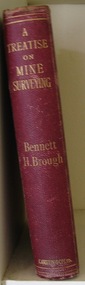
Book, Bennett H. BROUGH, Charles Griffin & Co. Ltd, "A treatise on mine surveying", C 1913
A. Part of the George Hadden collection B.Descibes in detail all aspects of mine surveying"A treatise on mine surveying" Hard Bound, red cover, gold lettering, 372 pages plus a 60 page advertising supplement.Inside front cover: "A.Blackburn Shottou Colliery Co. Durham.", "G.Hadden" -
 Wodonga & District Historical Society Inc
Functional object - Seal - Police Office, Belvoir
This seal was used for official police and court documents by the Belvoir Police Office.The initial land survey for the city now known as Wodonga was first undertaken in 1852 by Thomas Wedge - Assistant Surveyor. The new township was called "Belvoir" and was proclaimed by that name in 1852 and again in 1861. The first sale of land in Belvoir was held at Wangaratta on April 28, 1854, when all the allotments surveyed by Thomas Wedge (excepting those set apart for reserves, government and public areas) were offered at auction. Following representations by the Postmaster General on June 23, 1869, the Governor in Council, on July 12, 1869, approved of its Aboriginal name "Wodonga" being restored. The seal was found at the Yackandandah Courthouse by the Circuit Judge, the late Mr. Jim Humphrey. As the Wodonga Historical Society was in recess at that time, the seal was held in trust by the North-East Historical Society in Wangaratta. It was donated to the Wodonga Historical Society in 1987.This item was the official seal of the Belvoir Police office from the beginning of the European settlement of the modern day city of Wodonga, then know as Belvoir. It is one of the earliest relics of that period of history, until its name was changed in 1869.Wood and metal seal bearing the official emblem of the Police Office Belvoir. It would have been used to apply a wax seal to official documents. The seal is mounted in a timber and glass case so that the imprint of the seal can be seen reflected in a mirror mounted in the base of the box.Around the edges of the seal "POLICE OFFICE / BELVOIR"belvoir police, official seal, history wodonga -
 City of Kingston
Photograph - Black and white, 20 December 1945
Cheltenham is a suburb in the City of Kingston that was originally established as a rural market gardening community. The area is bordered by Highett, Mentone and Heatherton. The market gardens, farms and paddocks have gradually been sub-divided into housing and industrial estates. The Southland shopping centre is a major feature of the area.Cheltenham was established as a rural market gardening community. The Le Page family lived in Cheltenham since 1854 when Nicholas Le Page, a tailor from the Channel Island of Guernsey, bought two acres of land on Chesterville Road near Bernard Street to establish a market garden. Over the years the Le Pages purchased more land in the area. In 1875-76 Nicholas' son Frank and his wife Mary built 'Daphne Cottage' near the corner of Bernard and Wilson Streets. n the 1940s Frank's son, Everest Le Page, bought five more lots of land in Chesterville Road from the Tuck family. The Le Pages grazed horses, ponies and cows on this land, and grew pumpkins, carrots, parsnips, onions, potatoes and cabbages. Many buildings and locations within in Cheltenham commemorate the Le Page family's contribution to the Cheltenham community.Aerial photograph taken in 1945 of the Cheltenham district within the City of Kingston. The image includes Chesterville Road, the future site of Turner Road pool (now Waves) and Highett Reserve, (top left), Jellicoe Street, Argus Street, Bernard Street, Wilson Street, the Methodist Children Homes (now Southland), McIvor Street, Goulburn Street, Nepean Highway, Jamieson Street and Barker Street (bottom left), market gardens and paddocks. In the top centre of the image, "Daphne Cottage", the home of Frank T. Le Page is visible on the corner of Bernard and Wilson Streets. Much of the land depicted in this image was owned by the Le Page family. This image is possibly from the collection of aerial photographs commissioned by the Department of Crown Lands and Survey and taken by Adastra Airways.Black and white ink: 57250 White print: VIC-170 57250 20.12.45 Run 6 PROJ. No. 5 MELB. METROP AREA Black type 10200 FTS 30' LENS 20.12.45cheltenham, market gardens, industry, le page family