Showing 98 items
matching the breakwater and pier
-
 Port Melbourne Historical & Preservation Society
Photograph - Port Melbourne breakwater between the piers, Alison Kelly, 1991
... Port Melbourne breakwater between the piers ...Donated to the Society by the photographer Alison KellyColour photograph taken from the Port Melbourne breakwater between the piers looking into the bay. In distance two ships at anchor and the third (on right), the Australian Trader, is outboundtransport - shipping, australian trader -
Glenelg Shire Council Cultural Collection
Photograph - Photograph - Early Shipping: Ocean/Railway Pier, n.d
Port of Portland Authority Archivesport of portland archives, portland harbour, ship berthed -
Glenelg Shire Council Cultural Collection
Photograph - Photograph - Lee Breakwater, Portland, n.d
Port of Portland Authority ArchivesBack: 1/2 P --------biro 755port of portland archives, lee breakwater, construction, k s anderson wharf -
 Glenelg Shire Council Cultural Collection
Photograph - Photograph - Portland Harbour, n.d
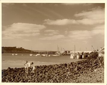
Con Kroker Private CollectionBlack & white photo. Fisherman's Breakwater on right. Ocean Pier, Whaler's Bluff lighthouse in background. Salt Creek running into sea on lfet, three children fossicking in rocks in foreground. -
Glenelg Shire Council Cultural Collection
Photograph - Photograph - Main Breakwater, Portland, n.d
Port of Portland Authority Archivesport of portland archives, main breakwater, construction, ocean pier, dutton way -
Port Melbourne Historical & Preservation Society
Photograph - Cruise ship, Fairstar, arriving at Outer West Station Pier, Port Melbourne, 5 Nov 1990
Colour photograph of cruise ship Fairstar arriving at Outer West Station Pier. In the foreground stands the outer beacon off the breakwater at Port Melbourne. Mounted in photocorners on white card.transport - shipping, fairstar, alison kelly -
Glenelg Shire Council Cultural Collection
Print - Contact Print - Portland Harbour, 1960-1970
Black and white contact print. Image shows Portland Harbour, from Town Hall. Fishermans Breakwater on right. Railway Pier and Ocean Pier on left. Two Steamers in bay and fishing fleet at anchor off Henty Beach. Foundations for 2nd Baths at Henty Beach.portland harbour, fishermans breakwater, railway pier, ocean pier -
Glenelg Shire Council Cultural Collection
Photograph - Photograph - Henty Beach, Portland Victoria, n.d
Black and white photo of Henty Beach Portland, looking south. Beach shelters, swings, dressing shed at end of pier, numerous people, Fishermen's Breakwater, Battery Point, Botanical gardens in the background.Back: '7338' - handwritten in pencil -
Glenelg Shire Council Cultural Collection
Photograph - Photograph - Early Shipping: Ocean/Railway Pier, n.d
Port of Portland Authority Archivesport of portland archives, portland harbour, lee breakwater, ocean pier, ks anderson construction -
 Warrnambool and District Historical Society Inc.
Postcard - Views of Warrnambool
Pictures depicting scenes of Warrnambool & District. 9 pictures are, The Beach. Hopkins River. Thunder Point. Liebig St. Botanical Gardens. Breakwater and pier. Hopkins River. Soldiers Memorial. Hopkins Falls.A typical souvenir postcard from the 1930'sOblong postcard with flip down views of Warrnambool from a purse with two kittensValentine's Mail Novelty Post Card; Good Luck And a Bagful of Views from WARRNAMBOOLwarrnambool, hopkins river, warrnambool breakwater, warrnambool postcards, postcards, hopkins falls, thunder point, soldiers memorial -
Glenelg Shire Council Cultural Collection
Postcard - Postcard - Portland Harbour, n.d
Coloured photo postcard, white border. View over baths and harbour at Portland, looking south east. Third Portland Baths, Ocean Pier, Railway Pier, fishing boats, Fishermen's Breakwater, Battery Point. 'THE BATHS AND HARBOUR, PORTLAND', white print lower edge of photo. No stamp or postmark on reverseBack: Hand written message, blue biro -
Glenelg Shire Council Cultural Collection
Negative - Negative - View over Harbour, Portland Victoria, Zilah Maschmedt, 1961
Negative for a black and white photograph. Image shows view over Portland Harbour, Whalers Bluff and lighthouse, right foreground, Lee Breakwater, Ocean Pier, LS Anderson Wharf, Battery Point and Lawrence Rocks. -
Glenelg Shire Council Cultural Collection
Photograph - Photograph - No 6 Berth, n.d
Port of Portland Authority Archivesport of portland archives, portland harbour, no 6 berth, construction, ocean pier, lee breakwater -
Glenelg Shire Council Cultural Collection
Photograph - Photograph - Early Shipping: Ocean/Railway Pier, n.d
Port of Portland Authority Archivesport of portland archives, portland harbour, ship berthed, lee breakwater, k s anderson wharf, ocean pier -
 Bayside Gallery - Bayside City Council Art & Heritage Collection
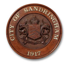
Plaque, City of Sandringham plaque
The Sandringham seal, which was designed by Sans and McDougall, had been selected in 1917 by a special committee and depicted as its main feature the Sandringham pier and breakwater, with a yacht in full sail, as an inset, and supported by two dolphins. The motto selected was Omni Opere ("With all earnestness.")Carved wood, with metal cast lettering. Carved relief City of Sandringham seal in the centre of the plaque with lettering 'CITY OF SANDRINGAM 1917' cast in metal around the border. On the central shield is the depiction of a large sailboat in the water at the top, below it an L-shaped pier protruding from the right and below that another pier protruding from the left with two small boats at the bottom. The shield is flanked by two dolphins, with St Edward's crown above, and a banner containing the motto 'OMNI OPERE' beneath. The area around the seal is decorated with a carved circular pattern.plaque, city of sandringham, sandringham coat of arms, seal, omni opere, bayside, coat of arms, crown, crest -
 Bayside Gallery - Bayside City Council Art & Heritage Collection
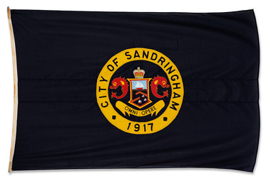
Flag, Gairs, City of Sandringham flag
The Flag contains the Sandringham seal, which was designed by Sans and McDougall, had been selected in 1917 by a special committee and depicted as its main feature the Sandringham pier and breakwater, with a yacht in full sail, as an inset, and supported by two dolphins. The motto selected was Omni Opere ("With all earnestness.").Dark blue flag with circular City of Sandringham seal in the centre with the words CITY OF SANDRINGHAM in yellow border around the outside. The seal contains a central shield depicting a large sailboat in the water at the top, below it an L-shaped pier protruding from the right and below that another pier protruding from the left with two small boats at the bottom. The shield is flanked by two dolphins, with St Edward's crown above, and a banner containing the motto 'OMNI OPERE' beneath. flag, city of sandringham, seal, crest, omni opere, pier, boat, motto, sans and mcdougall, with all earnestness, st edward's crown -
Port Melbourne Historical & Preservation Society
Photograph - Port Melbourne's changing waterfront, Ron Laing, 1999
Part of Ron Laing's collection of photographs recording Port Melbourne over a thirteen year period. Donated to the PMH&PS by the photographer.A set of 34 colour photographs of Port Melbourne's changing waterfront, covering the old and new harbor control tower on Fishermens Bend, restoration of the outer beacon, reconstruction of the west wing of Station Pier, demolition of the concrete 'steps' breakwater at Port Melbourne, reconstruction of the foreshore - Sandridge Beach to Beacon Roadbuilt environment, natural environment, demolitions, piers and wharves, ron laing -
 Warrnambool and District Historical Society Inc.
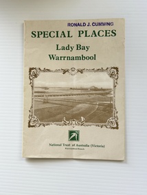
Pamphlet - Special Places Lady Bay Warrnambool, Philprint Warrnambool, 1989
This pamphlet was produced for the Warrnambool Branch of the National Trust of Australia (Victoria) for Heritage Week, April 16-23, 1989 and contains information written by Warrnambool residents about their locality. This was a co-operative venture by people with a common interest in protecting the natural environment near their home. Areas covered in the written information include: Formation of the Coast, Archaeological survey, Gunditjmara History, vegetation, history and recreational uses of the Lady Bay area. The map shows special places of interest including past and present navigational aids, sites of shipwrecks and other historical places of interest. The Warrnambool Branch of the National Trust was originally formed in March 1969 and merged with the Port Fairy Branch in late 1970. In October 1979, the Warrnambool Branch was reformed and operated into the late 1990's. This is an example of a publication produced by the Warrnambool Branch of the National Trust Australia (Victoria). It provides historical information and perspectives of the recreational uses in and around Lady Bay Warrnambool.An A2 piece of buff coloured thick paper folded into eight to make an A5 pamphlet. The front cover has green printing with the National Trust symbol of three eucalyptus leaves in green. There is a brown sepia photograph showing a view across Lady Bay with the suspension bridge across the Merri River in the foreground, Viaduct Road in the middle ground and the breakwater in the background. There is a purple inked stamp on the top right hand corner. The rear cover has brown writing and includes logos of bodies who assisted with the publication. There is a brown line drawing of the viaduct and pier at the Warrnambool Breakwater. The inside of the unfolded pamphlet contains a map of Lady Bay and adjacent area showing places of interest and shipwrecks marked in red circlesFront cover: Special Places Lady Bay Warrnambool National Trust of Australia (Victoria) Warrnambool Branch Ronald J. Cummingwarrnambool, lady bay warrnambool, national trust australia victoria warrnambool branch, heritage week 1989, lady bay shipwrecks -
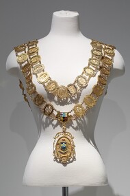 Bayside Gallery - Bayside City Council Art & Heritage Collection
Ceremonial object - Mayoral chain, Blashki, City of Sandringham Mayoral Chain, c. 1954
This chain was part of the official regalia worn by the Mayor of the City of Sandringham before the amalgamation into Bayside City Council in 1994. The chain was seen as an outward sign of power, authority, and responsibility and was a formal, full-dress type of regalia that was worn by the mayor over their robes at ceremonial functions. The large central drop medallion features the design of the council sea, and the links of the chains are made of cutwork initials of each Mayor. The Sandringham seal was designed by Sans and McDougal had been selected in 1917, by a special committee and its main features are the Sandringham pier and breakwater, with a yacht in full sail as an inset, supported by two dolphins. The motto reads 'Omni Opere' which translates to ‘With all earnestness.’9 carat yellow gold mayoral chain for the City of Sandringham. Consists of two concentric circles of 57 small oval links, with an Australian Coat of Arms as a centrepiece and a large 'drop' medallion of the City of Sandringham seal below. Each oval link is made up of the cutwork initials of a mayor, the surrounding oval border has an inscription above the initials which gives the mayor's name; an inscription below gives dates of office; the earliest is Cr. B.J. Ferdinando 1917-18, and latest is Cr. S.T. Russell 1993-94. The ovals are surrounded by decorative scrolls and are joined by small curb chains. The outer circle contains 31 links, while the inner contains 26. On both shoulders sit decorative bars, joining the front of the chain to the back. The main medallion has an oval central panel that features the coloured Sandringham seal in enamel depicting two sailboats in the water, a pier protruding from the left, a coastline on the right with two pine trees. Above the scene are decorative triangles in light blue and yellow, above which is another section in dark blue containing a third sailboat. The seal is flanked by two engraved dolphins and above it sits an engraved St Edward's gold crown filled with red enamel. Below the seal, there is a ribbon containing the Latin motto 'OMNI OPERE' which is engraved and filled in dark blue enamel. The pendant is surrounded by cutwork lettering reading 'CITY OF SANDRINGHAM / 1919' and leaf decorations. The medallion is inscribed on the reverse with important dates in Sandringham's history. A fleur-de-lys joins the medallion to the Australian Coat of Arms centrepiece above. The Coat of Arms features a shield, depicting symbols of Australia's six states, in enamel, flanked by an engraved kangaroo on the left and emu on the right. Below it sits a ribbon engraved 'ADVANCE AUSTRALIA'.mayoral chain, ceremonial wear, seal, medallion, mayor, coat of arms, crest, bayside, blashki & sons, city of sandringham, sandringham, omni opere, blashki, mayoral regalia, motto, st edward's crown, sans and mcdougall -
 Flagstaff Hill Maritime Museum and Village
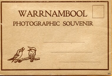
Postcard - Postcard Folder, scenes, Valentine & Sons Co. Publishing Ltd, Warrnambool Photographic Souvenir, Early-to-mod 20th century
... The Breakwater and Pier ...This postcard folder is one of three in a set of postcards that were published in Victoria, Australia, and collected together. The Valentine Publishing Co. Pty. Ltd. produced this folder. Valentine and Sons was a printing and photography business based in Dundee, Scotland, and in Canada. In the early 1900s, at the height of the postcard craze, the firm published large numbers of postcards in the U.K., Canada, U.S., Australia and South Africa. From around 1900 or earlier, the firm bought many lithographic images for its postcards from local and national photographers who sold publishing rights to Valentines, and the business was famous for publishing photographs of popular sites worldwide. Postcard titles in this folder include many of those in the Rose postcard folders plus the following titles that are not duplicated. . Municipal Buildings and Post Office . Soldiers’ Memorial . Hopkins River . The Cliffs at Shelly Beach . The Road to Sandy Beach . The Breakwater and Pier This Valentine postcard folder was produced in Australia. It includes pictures from the early-to-mid 20th century. It is one of three in a set, with images of the same locations as other images in our collection but at different periods in time. Each postcard records a moment in history and is significant as a way to compare and show the changes in the local environment and community, building a story of the local history. The images record changes in the coastline, land, bay, buildings and other structures, roads, transportation and even the fashions of the times.Postcard folder, Valentine Publishing, cream cover. One of a set of three displaying images of Warrnambool and district around the mid-20th century. Print on the front and back covers is in brown ink. The front has an image of two laughing kookaburras on a branch, three address lines and an outline for a postage stamp. The back cover has the publisher’s details and a line for a return address. The cover opens like a book, and then the double-sided, Z-folded page of photographs drops downward. Titles are printed below each of the fifteen black and white photographs inside. The folder is secured on the back cover by placing a tab into a slot. The folder was produced by The Valentine Publishing Co. Pty. Ltd. Melbourne“WARRNAMBOOL / PHOTOGRAPHIC SOUVENIR” Symbol: [Two facing kookaburras standing on a branch with beaks open] “Published by The Valentine Publishing Co. Pty. Ltd. Melbourne” flagstaff hill maritime museum and village, great ocean road, shipwreck coast, warrnambool, flagstaff hill, flagstaff hill maritime museum, flagstaff hill maritime village, warramble, postcard, postcard folder, warrnambool scenes, picturesque views of warrnambool, picturesque views of warramble, lady bay, port of warrnambool, breakwater, warrnambool breakwater, viaduct, merri river footbridge, merri river suspension bridge, suspension footbridge, merri river mouth, hopkins river mouth, proudfoot's, fanny nelson, nelson's boatsheds, nelson's boathouse, boathouse, hopkins river boathouses, flett's boathouse, flett, george rose, image of a rose, rose series, rose stereograph co, rose stereographic company, lighograph, armadale victoria, lady bay beach, beach scene, lower light, concrete footbridge, 1922 footbridge, viaduct road, rose postcard, new concrete bridge, 1945, 1890, 1922, small footbridge, 1872 footbridge, 1872, merri river estuary, stingray bay, postcards, concertina fold, z fold, shipwrecked coast, maritime museum, souvenir, warrnambool local scenes, photography, local history, tourism, photographs, visitors, travel, scenes, mid-20th century, 1940s, 1950s, z-fold, 1880s, collection, correspondence, valentine publishing co. pty. ltd melbourne, valentine publishing co. pty. ltd sydney, municipal buildings and post office, soldiers’ memorial, hopkins river, the cliffs at shelly beach, the road to sandy beach, the breakwater and pier -
 Flagstaff Hill Maritime Museum and Village
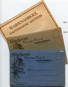
Postcard - Postcard Folder set, George Rose, Rose Stereographic Company, 1880-1942
Each postcard folder in this set has no address, message or postage stamp. Postcard folders such as these were popular as holiday souvenirs in the early to mid-20th century and were kept in good condition by collectors. The size is convenient for posting to friends and relatives and packing as holiday luggage. Postcards in the early-to-mid-19th century were an inexpensive way to remember and share holiday scenes, as few people could afford a camera and the price of developing the photographs. The images on these postcards were produced from black and white lithographs of photographs taken at Warrnambool and the surrounding district during the early to mid-20th century. Publishing firms such as Melbourne-based Valentine and Rose purchased photographs from local photographers and reproduced them for sale. This set of postcard folders shows that more than one publishing company had access to the same or almost the same images. The photographs include street scapes, the Warrnambool Breakwater and Pier, Botanical Gardens, beach scenes, cliff formations, the Hopkins River, municipal buildings, the Post Office and the Soldiers’ Memorial. The postcard folders in this set of three are significant as a record of local history from the late 19th century to the mid-20th century. The locations of the images match photographs and postcards in our collection that were taken at different times and provide a historical record of the Warrnambool and southwest Victorian locations, growth and changes.. The images record changes in the coastline, land, bay, buildings and other structures, roads, transportation and even the fashions of the times. Set of three postcard folders containing black and white images of photographed scenes showcasing Warrnambool and district between 1880 and 1942. The images were produced from lithographs of the original photographs and are printed on both sides of long strips of white photographic paper that are Z-folded into covers of textured card. Some of the images are repeated in all three folders. Folder 8665.1 - the cream-coloured folder was produced by The Valentine Publishing Co. Pty. Ltd. Melbourne and contains 15 photographs, some of which are also in the blue and the green folders. Folders 8665.2, the green folder, and 8665.3, the blue folder, were published by Rose Stereograph Co, Armadale, Vic. Each contains the same twelve images, but they are presented in a different order. flagstaff hill maritime museum and village, great ocean road, shipwreck coast, warrnambool, flagstaff hill, flagstaff hill maritime museum, flagstaff hill maritime village, warramble, postcard, postcard folder, warrnambool scenes, picturesque views of warrnambool, picturesque views of warramble, lady bay, port of warrnambool, breakwater, warrnambool breakwater, viaduct, merri river footbridge, merri river suspension bridge, suspension footbridge, merri river mouth, hopkins river mouth, proudfoot's, fanny nelson, nelson's boatsheds, nelson's boathouse, boathouse, hopkins river boathouses, flett's boathouse, flett, george rose, image of a rose, rose series, rose stereograph co, rose stereographic company, lighograph, armadale victoria, lady bay beach, beach scene, lower light, concrete footbridge, 1922 footbridge, viaduct road, rose postcard, new concrete bridge, 1945, 1890, 1922, small footbridge, 1872 footbridge, 1872, merri river estuary, stingray bay, postcards, shipwrecked coast, maritime museum, souvenir, warrnambool local scenes, hopkins river, botanic gardens, soldiers’ memorial, pier, post office, municipal buildings, merri river, proudfoot’s, the cliffs at shelly beach, the road to sandy beach, tourism, photographs, visitors, travel, scenes, local history, mid-20th century, 1940s, 1950s, rose stereograph co armadale. vic, valentine publishing co. pty. ltd melbourne, valentine publishing co. pty. ltd sydney -
 Phillip Island and District Historical Society Inc.
Photographs, 1940's to 1960's
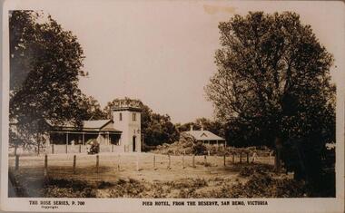
Part of a collection of photographs donated by Bruce Bennett. Photographs from collections of: David Johnson, I Mannix, Legg, Charlie Blackney, Des Chilcott, Ted Walton, Len Bagley and Brian Davis.233-20. Black & White photograph of a postcard. The Pier Hotel and house set in paddock and surrounded by large trees and reserve at San Remo, Victoria. 233-21. Black & White photograph of a photograph. Bentons Guesthouse, San Remo, Victoria. 233-22. Black & White photograph of a photograph. Herbie Kirkland or Clive Fox?? on barge at Newhaven, showing cray caufs lined up on jetty in the background. 233-23. Black & White photograph of a photograph. San Remo Hotel. 233-24. Black & White photograph of a photograph. Breakwater at San Remo circa 1940 with family on the beach (Bert Blackney & Violet) and people swimming. Wooden groyne in foreground. 233-25. Black & White photograph of a photograph. Building the slip at Newhaven, Phillip Island. 233-26. Black & White photograph of a photograph. House in the distance at Rhyll built by Johnson. Dan Patience lived there till 1950's then Ted Walton. 233-27. Black & White photograph of a photograph. San Remo to Newhaven, Phillip Island punt with 3 cars on board. 233-28. Black & White photograph of a photograph. San Remo jetty showing boats and sheds. Ivan Hayhow boat. 233-29. Black & White photograph of a photograph. Sailing boat on Westernport with Phillip Island Suspension bridge behind.233-20 The Rose Series P700. Pier Hotel, from the reserve, San Remo, Victoriahotels, pier hotel san remo victoria, san remo hotel victoria, bentons guesthouse san remo, guesthouses, san remo to newhaven barge, phillip island barge, newhaven barge, san remo beach, newhaven slip phillip island, rhyll phillip island, san remo punt, san remo jetty, phillip island suspension bridge, sailing boats, bruce bennett -
 Flagstaff Hill Maritime Museum and Village
Document - Navigation Chart, Admiralty Office, Lady Bay and Warrnambool Harbour, 03/04/1871
This Chart titled “Lady Bay and Warrnambool Harbour” was surveyed by Nav. Lieut. H.J. Stanley, of Britain's Royal Navy, in 1870 and printed in April 1871. The chart was made before the Warrnambool Breakwater was built (construction had begun in 1874 and was completed in 1890). The chart includes Directions for entering Lady Bay, Warrnambool Harbour. These are "Vessels entering Warrnambool Harbour must bring the Red Light in sight and steer in with it in line with the upper white Light bearing North, until the Green Light on the Jetty is opened, when steer towards it and anchor. The best anchorage is in 2 ¼ fms [fathoms)] of water, about a cable from ledge off Breakwater rock. Or where convenient, according to draught of water, only endeavouring to anchor as close as possible to Breakwater rock. It is not safe to enter or leave the Harbour in south westerly or Southerly gales.” This chart is significant for its strong connection to the maritime history of Warrnambool Harbour and Lady Bay, and eventually to the Warrnambool Breakwater. The Warrnambool Breakwater is registered as a place of significance on the Victorian Heritage Database (VHR H2024). A copy of the same chart was used to plan several submissions for future changes to the jetty and breakwater. The chart is a historical record of structures existing in 1870; the Warrnambool Jetties, Lady Bay, the leading lights (lighthouses), streets, roads, bridges and many buildings. It also shows the lay of the land and seabed.Canvas chart of Australia, South Coast, Victoria Title: Lady Bay and Warrnambool Harbour Surveyed by Nav. Lieut. H.J. Stanley, R.N., 1870. Magnet Variation, 1870 Published April 3, 1871, by the Admiralty, London. Directions for vessels entering Warrnambool Harbour are printed on the chart. The chart has a lacquer or seal over it.Top of chart has logo "HYDROGRAPHER OFFICE" "Price Eighteen Pence". "Engraved by Edward Weller" Along bottom of Chart: “London… Published at the Admiralty, 3rd April 1871, under the Superintendence of Rear Admiral G.H. Richards, F.R.S. Hydrographer, Corrections July 71” Bottom of chart “Australia South Coast Victoria Lady Bay and Warrnambool Harbour. 2494”flagstaff hill, warrnambool, chart of lady bay warrnambool 1870, warrnambool harbour, cartography, navigation, warrnambool breakwater, 1871, australia – south coast / victoria, lady bay, 1870, nav. lieut. h.j. stanley, r.n, directions for entering warrnambool harbour, hydrographer office, rear admiral g.h. richards, edward weller, port of warrnambool, flagstaff hill maritime museum & village, maritime museum, maritime village, shipwreck coast, map, chart, navigation chart, admiralty chart, breakwater, jetty, pier, vhr h2024 -
Glenelg Shire Council Cultural Collection
Photograph - Photograph - Lee Breakwater, Portland, n.d
Port of Portland Authority Archivesport of portland archives, lee breakwater, tanker berth, wharf, harbour, barge -
Glenelg Shire Council Cultural Collection
Photograph - Photograph - Lee Breakwater, Portland, n.d
Port of Portland Authority ArchivesFront: 6 1/4 inside - Horizontal arrows & 4 3/8 inside - Vertical arrowsport of portland archives, lee breakwater, construction, tanker berth -
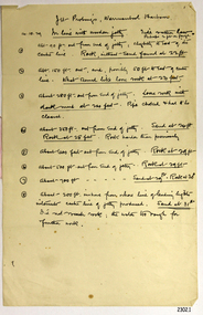 Flagstaff Hill Maritime Museum and Village
Document - Report, Jet Probings, Warrnambool Harbour, 16-10-1929
This report lists the depths of water and the consistency of the seabed surrounding the Warrnambool Harbour in October 1929, The information, often referred to as 'soundings', was obtained by Jet Probing,. In earlier days a lead line was used to perform a similar task. The author of the document is unknown. Jet Probing is a method used for underwater archaeology, cable installation and coastal engineering. A jet probe is a machine that produces a strong jet of water that penetrates the layers of sediment on the seabed, determining their depth, thickness and consistency. It provides a survey of the seabed and can be used as an aid to engineering design and construction. The report mentions lining up with the wooden jetty, the end of the breakwater and the leading lights. It mentions sand, loose rock and rock. It tells of stopping work due to the water being too rough, the pipe choking, difficulty in connecting pipes, and pipe joint breaking as it tried to get through the sand, The report in the document is significant for its connection with the Warrnambool Harbour, Warrnambool Breakwater, Warrnambool Jetty and Lady Bay. The report gives figures for the depth and consistency of the water and seabed at a particular point in time and can be used to compart with similar figures taken at different times. The results could determine plans for future engineering works.Report, titled 'Jet Probings, Warrnambool Harbour'. Two pages of cream coloured paper with hand written notes in pen and ink. Report covers three days of Jet Probings, with resulting figures and comments, for the depths of the surroundings of the Warrnambool Harbour. The report is in point form, with some underlining. Dates of recordings are 14-10-29, 15-10-29 and 16-10-29. (1929) The situation of the harbour had become a real problem by 1910 and required continuous dredging. In 1914 the Breakwater was extended but proved to be a failure because the work began to subside and by 1920 about two thirds of the harbour was silted up. Alterations made in the 1920's increased the silting problem. The soundings and Jet Probings were done after the Royal Commission of 1923, when the damaged stonework on the seaward side of the Warrnambool Breakwater, caused by the action of the sea, was the subject of enquiry. A conference between the Public Works, Water Commission and the Harbour Trust concluded that it would less costly to make repairs to prevent further damage rather than replaced the damage portion of the wall. A contract was raised in late 1924 to deposit rubble on the damaged side of the breakwater to minimise the Southern Ocean’s destructive action and work had started by August 1925. By the 1940's the harbour was no longer used. More alterations were made in the 1950's and 1960's. document, depth, warrnambool harbour, 1929, soundings, jet probe, jet probing, seabed, map of seabed, underwater engineering, warrnambool jetty, warrnambool breakwater, breakwater upgrade, leading lights, chart the harbour, flagstaff hill, warrnambool, flagstaff hill maritime museum & village, maritime museum, maritime village, shipwreck coast, lady bay, port of warrnambool, breakwater, jetty, pier, vhr h2024, royal commission, 1923, public works, water commission, harbour trust, victorian harbours -
 Flagstaff Hill Maritime Museum and Village
Document - Navigation Chart, Admiralty Office, Lady Bay and Warrnambool Harbour, 1893
This navigation cart of Lady Bay and Warrnambool Harbour was originally surveyed in 1870 but this version includes the update for magnetic variation in 1893. Since the printing of the chart several annotations have been added. These include an additional stamp dated 15-8-1910, a handwritten comment across the top of the page dated August 1910, and another handwritten comment regarding the ‘Proposed Extension of Dock’ dated 19-2-1925, plus connected drawings, notes and figures. The 1925 proposal on this chart may have been a reaction to the Royal Commission of 1923, when the damaged stonework on the seaward side of the Warrnambool Breakwater, caused by the action of the sea, was the subject of enquiry. A conference between the Public Works, Water Commission and the Harbour Trust concluded that it would less costly to make repairs to prevent further damage rather than replaced the damage portion of the wall. A contract was raised in late 1924 to deposit rubble on the damaged side of the breakwater to minimise the Southern Ocean’s destructive action and work had started by August 1925. The Breakwater construction had begun in 1874 and was completed in 1890. The Victorian Government had commissioned Sir John Coode, a British harbour engineer, to present a plan to complete the Warrnambool Breakwater but his original plan was too expensive. He prepared a revised plan for a shorter structure. The construction proved to be too short to protect adequately from the weather and didn't allow enough depth for larger vessels to come into port. The decreasing trade was further affected by siltation in the bay due to the breakwater, and the completion of the railway line. The situation of the harbour became a real problem by 1910 and required continuous dredging. In 1914 the Breakwater was extended but proved to be a failure because the work began to subside and by 1920 about two thirds of the harbour was silted up. Alterations made in the 1920's increased the silting problem and by the 1940's the harbour was no longer used. More alterations were made in the 1950's and 1960's. This chart is significant for its strong connection to the maritime history of Warrnambool Harbour and Lady Bay and the Warrnambool Breakwater. The Warrnambool Breakwater is registered as a place of significance on the Victorian Heritage Database (VHR H2024). The Warrnambool Breakwater is one of the most important late 19th century maritime engineering projects in Victoria and significant in the development of Victorian coastal shipping. It is also significant for its connection with British harbour engineer, Sir John Coode. The chart is a historical record of structures existing in 1893; the Warrnambool Jetties, Warrnambool Breakwater in Lady Bay, the leading lights (lighthouses), streets, roads, bridges and many buildings. It also shows the lay of the land and seabed. Navigation Chart: Lady Bay and Warrnambool Harbour, Australia - South Coast - Victoria. Surveyed by Nav. Lieut. H.J. Stanley, R.N., 1870. Updated for Magnetic Variation, 1893. The rectangular chart is printed on heavy cream paper. Stamps are shaped rectangular, oval and round. Around the Breakwater and Jetty area are handwritten notes, dotted and joined lines, numbers and signatures, and shading of red and green. The chart shows the surrounds of Warrnambool Harbour, Lady Bay, the Breakwater and Jetty, roads, bridges and the streets in Warrnambool. It has sounding details, and angles of line from the leading lights.Stamp, rectangular, including "AUG 1910" Stamp, double oval " - - - -CHART" Stamp, hand drawn, red circle, with "B" inside Hand written note "22-8-1910 - - - - - of surveying C. Ca - - - request of 15-8-10 [initials] " Notes and lines in red pen, including a grid of sounding numbers: "1300" "1050" "1200" "Possible Extension of Dock" "19-2-25" "Dock Dredged to 20 Ft" Notes and lines in blue pen "Extension of Dock to accommodate vessels drawing 20 Feet" and "Light not visible south of this line" Red dots (4) with yellow highlight at both leading lights, breakwater and jettyflagstaff hill, warrnambool, flagstaff hill maritime museum & village, maritime museum, maritime village, shipwreck coast, map, chart, navigation chart, plan, lady bay, warrnambool harbour, port of warrnambool, breakwater, jetty, pier, dock extension, proposed extension, vhr h2024, 1870, 1893, 1910, 1925, warrnambool town late 1800s, warrnambool streets late 1800s royal commission, 1923, public works, water commission, harbour trust, victorian harbours, sir jon coode -
Glenelg Shire Council Cultural Collection
Photograph - Photograph - Aerial black and white photograph of Portland harbour and foreshore taken from the N.E. Cape Nelson in background, 07/07/1968
Port of Portland Authority archivesFront: (no inscriptions) Back: 'Port area with Cape Nelson in background 7/7/1968 (at 800 feet) Harbour basin with 600ft entrance between breakwaters.port of portland archives, cape nelson, no6 berth construction, ocean pier -
Glenelg Shire Council Cultural Collection
Photograph - Photograph - Aerial black and white photograph of Portland Harbour and foreshore taken from the N.E. Cape Nelson in background, 07/07/1968
Port of Portland Authority archivesFront: (no inscriptions) Back: 'Port area with Cape Nelson in background 7/7/1968 (at 800 feet) Harbour basin with 600ft entrance between breakwaters.port of portland archives, cape nelson -
Glenelg Shire Council Cultural Collection
Photograph - Photograph - Main Breakwater construction, Portland, n.d
Port of Portland Authority Archivesport of portland archives, harbour construction, development, wharf