Showing 945 items matching "reservoir"
-
 Warrnambool and District Historical Society Inc.
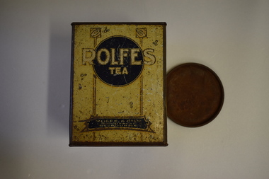
Tea Tin (Rolfe), Artefact, Early 20th century
This is a tea tin from the business of Rolfe and Co., a wholesale grocery and importing business founded in Melbourne in 1854 by George Rolfe Senior, a merchant and politician. George Rolfe died in 1871 and the business was then run by his son, George Rolfe, Junior. The business continued until at least the late 1930s. George Rolfe (1836-1919) was a keen sportsman and he began holidaying in Warrnambool for some years in the 1870s when he started buying land in the area. By the early 1880s Rolfe owned 50 acres in Warrnambool and established his holiday residence at Lyndoch near the mouth of the Hopkins River. He improved the original site with the addition of a large garden, stables, jetty, boatshed, water well, chaff and bone sheds, reservoir etc and bought other properties including Shipley on the Allansford Road and the adjoining property Fairy Hill. He continued managing the Rolfe and Co. business in Melbourne until his death in 1919. Today Rolfe’s Lyndoch property in Warrnambool is the site of an aged care facility. This tin is of considerable significance as it is a memento of George Rolfe who established the property of Lyndoch in Warrnambool and was a prominent land holder in the late 19th and early 20th centuries. (Note that we have another Rolfe tea tin but it is in very poor condition compared to this later acquisition). This is a rectangular-shaped tin with four sides originally painted yellow but now showing considerable rust. The printing on the sides is brown and white, some on a blue background and some surrounded by decorative patterns.No. 2 Rolfe & Co. Ltd 286-300 King St. Melbourne Rolfe’s Tea Rolfe and Co. was established at Melbourne in 1854. Ever since then it has enjoyed an enviable reputation as a firm which supplies to the public goods of the highest quality. george rolfe, lyndoch warrnambool, rolfe & co, importers, melbourne, history of warrnambool -
 Eltham District Historical Society Inc
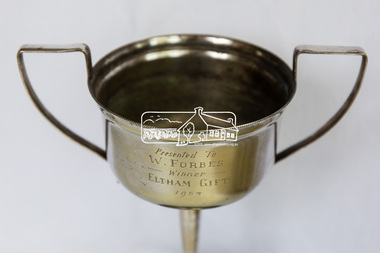
Decorative object - Trophy, Winner's Cup, Eltham Gift 1954, 1954
Presented to W. Forbes Raymond (Billy) William Forbes 1934-2008 Born Nyah West, Vic and died Echuca, Vic, Billy was a painter and decorator in the 1950s before joining the Melbourne Metropolitan Fire Brigade in the 1960s. In the 1970s he was employed at the Melbourne Metropolitan Board of Works until his retirement in 1991. In the 1930s he was raised in Nyah West then moved to Wallan in the 1940s, Collingwood/Carlton in the 1950s, Reservoir in 1970 then Torrumbarry, Vic from the 1990s. Billy undertook National Service in the 1950s and played football with the Carlton Royals in the 1950s and 1960s. Billy was presented with this Winner's Trophy for the 1954 Eltham Gift. The Eltham Gift was a running race similar to many other 'Gift' races around the the Melbourne suburbs and country towns. And that is where the mystery lies as press reports of the day have a completely different person winning the Eltham Gift in 1954. Bert Edwards was recorded in local news as winning the 1954 Eltham Gift held at Central Park Eltham. Brass alloy silver plated cup (engraved) on brown baketlite platic basePresented to W. Forbes, Winner, Eltham Gift, 1954eltham gift 1954, raymond (billy) william forbes 1934-2008, running race, sports, trophy, w. forbes, winner's cup, central park, athletics -
 Port Melbourne Historical & Preservation Society
Document - Victorian Railway tickets, c. 1960' & 70's
From the collection of Warren DOUBLEDAY. Tickets were given to donor by retired railway officials who were given access to them for their collections following the tickets withdrawal from use. Fifteen are for journeys to and from the Port Melbourne station and include Single, Weekly and 'Extended Periodical' tickets.Those from Graham Street Station include three singles & one 'Periodical Pass'. As well as the singles & weekly tickets, the 24 to & from North Port Station also include a 'Periodical Pass' and one for a 'Collapsible Pram'. . From Montague Station single and weekly journeys make up the eight tickets. The weekly tickets show how far people would travel to work in Port Melbourne. From Ascot Vale, Broadmeadows, Carrum, Coburg, Gowrie, Malvern, Mont Albert, Reservoir, St Albans, Thorrnbury, Williamstown, Yarramam. Single tickets are for travel to or from Auburn, Clayton, Collingwood, Glenferrie, Hawthorn, Kensington, Melbourne, Mont Albert, Moonee Ponds, Richmond, West Footscray, A collection of 51 undated railway tickets.transport - railways, north port station, graham station, montague station, port melbourne station -
 Wodonga & District Historical Society Inc
Photograph - Mitta Junction Township
Mitta Junction which was established about 1920 on the Victorian side of the Hume Dam construction site (originally called the Mitta Junction Reservoir). The town was built to house workers and their families. It included houses, private and government boarding houses, a shop, hall and school as well as tennis courts and a cricket pitch. Mitta Junction was a thriving community with many activities, including Balls and Euchre Nights, held at the Hall which opened in February 1922. The community also fielded a very successful football team in the local competition. After the completion of the Dam, the village and all its contents were sold at auction in June 1936 for £7,000. Individual houses sold at about £40 for removal to nearby towns. The Mitta Junction School which opened in 1922 continued to operate with very small numbers after the village was moved. Its numbers were boosted in the early 1980s by the children of Army staff at the nearby Latchford Barracks Army Apprenticeship School. It finally closed in December 1985.These images are significant because they capture the history of an important vanished town whose residents played a vital role in the construction of the Hume Dam.A collection of black and white images and a sketch map featuring the village of Mitta Junction, built to house workers on the construction of the Hume Dam. Some of the photographs have been mounted on heavy card.mitta junction township, hume dam construction, hume dam history -
 Geoffrey Kaye Museum of Anaesthetic History
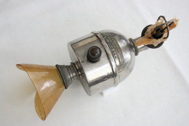
Equipment - Inhaler, Clover, The Holborn Surgical Instrument Company, 1877
Dr. Joseph Clover (1825-1882), an English physician, first described his Portable Regulating Ether Inhaler on Jan. 20, 1877. Clover was an especially sought after anesthesiologist and early pioneer in the specialty. This was the best-known of many inhalers that Clover designed. The dome-shaped reservoir was turned to points on a control dial to gradually increase or decrease the percentage of the air that passed over the ether. Several inventors based new inhalers on this, while the original continued to be manufactured as late as the beginning of WWII. Clover, to spare the patient the unpleasantness of induction with his "closed" inhaler (1877), suggested the "mitigated-ether" technique. The inhaler was fitted with a bypass tap for the reception of N2O. The bag was filled with the gas and anaesthesia was inducted a combination of N2O and asphyxiation. Ether was then admitted gradually by rotation of the bowl of the inhaler. When the patient had been duly "weaned over" to ether, the mask was lifted, the N2O allowed to escape, the bag refilled with exhaled air, and normal anaesthesia "a la Clover's inhaler" was continued.Metal domed chamber with a bulb attachment for rebreather bag, including a tap mechanism. Remnants of the paper rebreather bag are attached to the bulb. At the other end is a yellow facemask made of plastic (probably celluloid). The manufacturer's logo has been moulded into the dome of the chamber.Manufacturer's logo: THE HOLBORN / SURGICAL INSTRUMENT CO. LTD. / LONDON •Blue sticker with white writing: O.2.4.joseph clover, mitigated-ether, nitrous oxide, n2o, closed method -
 Ballarat Tramway Museum
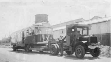
Photograph - Black & White Photograph/s, Yellow Express, 1942
Black and white photograph of Victorian Railway's Tram No. 52 being delivered to Elwood depot during 1942 by Yellow Express prime mover and low loader trailer - Truck registration - DP 635. Has the depot and water tower in the background and a person, the driver? alongside the truck. See image i1 for the details on the rear. Destination City, 4th Edition for date of manufacture.On rear of photograph in ink. 1. On left hand edge "PS can destroy photo when finished" 2. On upper 2/3rds of back "Photo wires being taken down to allow 1/2 section house to past it being 19-6 x 48 x 23 wide. Transported Preston to Reservoir by Yellow Express Melbourne Victoria" - would appear to refer to another photograph. - Dimensions in feet? 3. On lower 1/3rd, "Tram being transported Newport Railway Workshops to Elwood Depot , 11 mile. 45 long x 8-6 x 10 / Yellow Expx". Dimensions in feet.trams, tramways, vr, st kilda brighton tramway, elwood depot, vr class tramcars, yellow express, tram 52 -
 Bendigo Historical Society Inc.
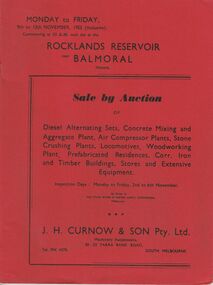
Document - IAN DYETT COLLECTION: AUCTION CATALOGUE - ROCKLANDS RESERVOIR
Red covered catalogue for a Sale by Auction at Rocklands Reservoir near Balmoral, Vic. On the 9th to 13th November, 1953 (inclusive). For sale are Diesel Alternating Sets, Concrete Mixing and Aggregate Plant, Air Compressor Plants, Stone Crushing Plants, Locomotives, Woodworking Plant, Prefabricated Residences, Corr. Iron and Timber Buildings Stores and Extensive Equipment by order of The State Rivers & Water Supply Commission, Melbourne. Pasted in the front of catalogue is a slip to write name, address and phone number on and to give to clerk when making their first purchase. A typed note loose in the front of catalogue mentions that the time for removal of houses and buildings has been increased from four weeks to three months and goods would be at purchaser's own risk after time of sale. Descriptions of some of the items for sale. Catalogue has Ground Plans of the eight different residential houses. J. H. Curnow & Son Pty. Ltd. Were the auctioneers.business, auctioneers, j h curnow & son pty ltd, ian dyett collection - auction catalogue - rocklands reservoir, the state rivers & water supply commission, j h curnow & son pty ltd, balmoral combined women's associations, prahran telegraph printing co -
 The Beechworth Burke Museum
Photograph, Unknown c.1930s
This image shows Bethanga Bridge, which was constructed between 1927 and 1930 in Albury, NSW. The bridge was a necessity due to the building of the Hume Dam (Wier), 1919-1936. Bethanga Bridge is a long, nine-span, riveted-steel, variable depth, Pratt Truss road bridge of nine principal spans of 82 metres and a total length of 752 metres over the flooded valley of the Murray River, now part of Hume Reservoir. Because of its unique location, over the waters of a dam with the border running down the centre of the body of water, the Bethanga bridge is the only built structure shared by both New South Wales and Victoria. It was built 1.6 kilometres upstream of the dam and in 1961 was raised 300mm, with a concrete deck replacing the original wooden deck. The State Rivers and Water Supply Commission of Victoria and the New South Wales Department of Public Works were responsible for the construction works for the Hume Weir under the River Murray Waters Agreement. It is apparent that a similar joint arrangement was made for the construction of the Bethanga Bridge as part of the Hume Weir works.This photograph of the Bethanga Bridge is of historical significance as it showcases the architectural skills of Percy Allen and Vincent Packer. Additionally, it reveals the environmental landscape of the 1920s-1930s, is linked to the Hume Dam and both New South Wales and Victorian heritage. Unmounted black and white rectangular photograph. Reverse: 1997.3196 84-20-3bethanga, bethanga bridge, hume dam, pratt truss, murray river, hume weir, transportation -
 Bendigo Historical Society Inc.
Photograph - HILDA HILL COLLECTION: BLACK AND WHITE PHOTOS, 1922
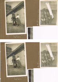
Series of Black & White Photos Total 5 of the Hill Family & Friends during leisure in 1922. Mollie dressed on black with white blouse astride a horse & Hilda wearing a tartan skirt with a white blouse, at the Durvol Property Kyneton Victoria Australia September 1922. Four young ladies all wearing a dark colour dress with white blouse, two are wearing dark hats and two white, sitting on a metal ended wooden slat seat, Castlemaine 1922.Nora Nellie Jonah sitting on a rocky outcrop, two wearing dark clothing with white blouses on in lighter colour wearing hat with white bands on crown. At Inglewood November 8th 1922, Six males al dressed in dark suits with white shirts and dark ties, also six ladies one in coloured dress others all in white one wearing a tartan like pattern skirt, one lady has dark hat another light coloured. Enjoying the Reservoir Inglewood 1922.Hilda Hill Perrsonal Collectionaustralia, history, post war life -
 Warrnambool and District Historical Society Inc.
Certificate - Federation Celebration Rolfe invitation, 1901
This invitation to a ‘Conversazione’ to celebrate the Federation of the six colonies in Australia into the six States of Australia in 1901 was sent to the invitees after the event to keep as a souvenir of the occasion. The event was hosted by the Government of Victoria. The certificate was designed by George Brougham Austin, a Melbourne architect and artist employed by the Victorian Department of Public Works. He also designed many of the public decorations displayed in Melbourne during the Federation celebrations. Austin’s original work was lithographed by an artist at Sands and McDougall, Melbourne. This particular invitation was sent to George Rolfe and his wife, Annie. George Rolfe (1836-1919), a tea merchant from Melbourne, began buying blocks of land near the mouth of the Hopkins River in Warrnambool in the 1870s. By the early 1880s he owned 50 acres of land in the town and some nearby farming properties. He used the building on the ]and near the mouth of the Hopkins River as holiday accommodation and called the property, Lyndoch. He improved the property with the additions of stables, jetty, boathouse, bone and chaff sheds, reservoir and windmill and extensive gardens. Rolfe spent most of his later life at Lyndoch. Today the property is the site of an Aged Care facility. This certificate is of considerable importance for two reasons: 1. It is an important and attractive memento of a signal event in the history of Australia – the Federation of the States in 1901. 2. The certificate was an invitation to Mr and Mrs George Rolfe. George Rolfe was a prominent Warrnambool person in the late 19th and early 20th centuries. This is a multi-coloured certificate printed on a cream-coloured card. The certificate has an image of the Exhibition Building surrounded by an ornate border of heraldic shields, portraits of the Duke and Duchess of Cornwall and York, views of the six capital cities of Australia, native flora and fauna, the Royal Crest and the Crest of Australia. The names of the invitees are handwritten in black ink. ‘United Australia 1901 One Flag One Hope One Destiny Australian Commonwealth Celebrations’ ‘The Government of Victoria requests the honor of the presence of Mr & Mrs G. Rolfe at a Conversazione in the Exhibition Building on the Evening of Tuesday 7th May 1901 at 8 p.m.’ george rolfe of lyndoch, warrnambool, federation of australia, history of warrnambool, george rolfe -
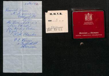 Melbourne Tram Museum
Ephemera - Personal Papers in a Benson & Hedges tin, 1950s
Allan Yoemans was a tramway employee at Preston depot. Receipts contained within the Benson and Hedges tin of the early 1950s noting it is by appointment to HM King George V are: 1 - Receipt for a ladies cycle - 9 pounds - dated 2/11/1957 2 - MMTB clothing docket for a coat - size 6 3 - Receipt on MMTB letterhead and docket - payment of Tramway Benefit Society subscription - dated 3/12/1956 - received at Preston Revenue office 4 - Receipt for 170 pounds - payment for a Chev sedan car with a Victorian 3d duty stamp, dated 13-4-53 5 - Receipt for payment of 4/6, Ezyart Co of Reservoir showing a balance of 1pound and 10 shillings - hire purchase? - dated 21/9/1950 6 - Receipt from Bruce Small Pty Ltd for payment of 15 pounds, a/c Bicycle finance - with a Victorian 2d duty stamp, dated 8/4/1952 7 - Interim receipt for 5 pounds from the Lalor Consumer Co-op dated 26-9-1950 At the time Mr Yoemans lived in Gratwick St Lalor.Shows business practices of the early 1950s and the way payments such as hire purchase could be made and receipted, including payments to the Tramway Benefit Society.Metal tin or cigarette container - red for 20 Benson & Hedges cigarettes containing 7 paper receipts or dockets.tramway benefit society, tbs, receipts, financial records, tramway employee -
 Broadmeadows Historical Society & Museum
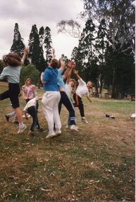
Photograph - Picnic Photograph, Moments in Midair, 1990
This photograph, likely taken during Jacana Primary School’s 1990 Christmas picnic at Greenvale Reservoir, captures a dynamic moment of childhood play and joy. A group of children is seen mid-jump in a grassy park surrounded by tall trees, their movement and energy reflecting the carefree spirit of the occasion. The image offers a vivid snapshot of outdoor recreational activities that were central to the school’s end-of-year celebrations. Jacana Primary School, established in 1959 and closed in the early 2000s, was a vital institution in Melbourne’s northern suburbs. Known for its strong emphasis on both academic and social development, the school fostered a culture of inclusivity and community engagement. Events like the annual Christmas picnic were more than festive gatherings—they were opportunities for students, staff, and families to connect, celebrate, and reinforce the school’s values in a relaxed, natural setting. This photograph is historically significant as it documents the lived experiences of students during a period when outdoor play and communal events were integral to primary education. It reflects broader educational practices of the time, where physical activity, social interaction, and connection to nature were seen as essential components of a well-rounded schooling experience.This photograph is a culturally and historically significant record of Jacana Primary School’s community life in the late 20th century. Captured during the 1990 Christmas picnic—likely held at Greenvale Reservoir—it depicts a group of children mid-jump in a moment of spontaneous outdoor play. The image embodies the spirit of joy, freedom, and social connection that characterised the school’s end-of-year celebrations. Jacana Primary School, which operated from 1959 until the early 2000s, was a cornerstone of Melbourne’s northern suburbs, known for its commitment to inclusive education and community engagement. Events such as the annual picnic were integral to the school’s ethos, reinforcing bonds between students, staff, and families in informal, nature-based settings. The photograph is significant not only as a visual document of a specific event but also as a broader representation of educational values of the time—emphasising physical activity, social development, and the importance of shared experiences. It contributes to the historical narrative of public schooling in Victoria and preserves the memory of a school community that played a formative role in the lives of many local families.Colour Photograph on glossy paper in landscape formatPH18289 (crossed out) PH-4209 (crossed out) PH-4868/this paper/manufactured/by Kodakjacana primary school, christmas party, 1990, jacana -
 Eltham District Historical Society Inc
Photograph, Yan Yean, 1987, 1987
Originally contained in a 'magnetic' photo album of scenic photos of Yan Yean and Warrandyte believed to be donated by Mrs Eric Stephenson, Jingalong, 110 Ryans Road, Eltham, Vic. 3095; relocated to archival safe storage. On the 20th December 1853 Lieut Governor Charles LaTrobe took his spade to turn the first sod of an embankment across the swampy bed of the Plenty River at a lonely place called Yan Yean, in order to create Melbourne’s first water supply. In the early 1850’s water had been drawn from the Yarra which even then was known as Yarra Soup. A convict by the name of James Blackburn produced the basic design for supplying water to Melbourne from a reservoir on the Plenty River at Yan Yean, and later on he was appointed consulting engineer on the project. In 1853 a contract was let for the building of the wall for 91 thousand 575 pounds, and at one stage some 400 labourers were at work in the area. A tramway was constructed to convey stone and other materials from Melbourne. So famous was this magnificent stretch of water that illustrations of the bluestone embankment and tower appeared in London journals Whittlesea Historical Society – Historic items for Diamond Valley Community Radio September 1990 Colour photographyan yean, yan yean reservoir -
 Eltham District Historical Society Inc
Photograph, Yan Yean, 1987, 1987
Originally contained in a 'magnetic' photo album of scenic photos of Yan Yean and Warrandyte believed to be donated by Mrs Eric Stephenson, Jingalong, 110 Ryans Road, Eltham, Vic. 3095; relocated to archival safe storage. On the 20th December 1853 Lieut Governor Charles LaTrobe took his spade to turn the first sod of an embankment across the swampy bed of the Plenty River at a lonely place called Yan Yean, in order to create Melbourne’s first water supply. In the early 1850’s water had been drawn from the Yarra which even then was known as Yarra Soup. A convict by the name of James Blackburn produced the basic design for supplying water to Melbourne from a reservoir on the Plenty River at Yan Yean, and later on he was appointed consulting engineer on the project. In 1853 a contract was let for the building of the wall for 91 thousand 575 pounds, and at one stage some 400 labourers were at work in the area. A tramway was constructed to convey stone and other materials from Melbourne. So famous was this magnificent stretch of water that illustrations of the bluestone embankment and tower appeared in London journals Whittlesea Historical Society – Historic items for Diamond Valley Community Radio September 1990Colour photographyan yean, yan yean reservoir -
 Eltham District Historical Society Inc
Photograph, Yan Yean, 1988, 1988
Originally contained in a 'magnetic' photo album of scenic photos of Yan Yean and Warrandyte believed to be donated by Mrs Eric Stephenson, Jingalong, 110 Ryans Road, Eltham, Vic. 3095; relocated to archival safe storage. On the 20th December 1853 Lieut Governor Charles LaTrobe took his spade to turn the first sod of an embankment across the swampy bed of the Plenty River at a lonely place called Yan Yean, in order to create Melbourne’s first water supply. In the early 1850’s water had been drawn from the Yarra which even then was known as Yarra Soup. A convict by the name of James Blackburn produced the basic design for supplying water to Melbourne from a reservoir on the Plenty River at Yan Yean, and later on he was appointed consulting engineer on the project. In 1853 a contract was let for the building of the wall for 91 thousand 575 pounds, and at one stage some 400 labourers were at work in the area. A tramway was constructed to convey stone and other materials from Melbourne. So famous was this magnificent stretch of water that illustrations of the bluestone embankment and tower appeared in London journals Whittlesea Historical Society – Historic items for Diamond Valley Community Radio September 1990 Colour photographyan yean, yan yean reservoir -
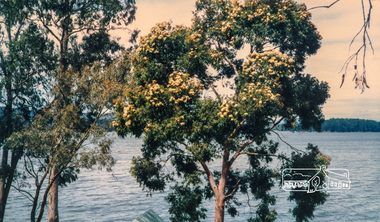 Eltham District Historical Society Inc
Photograph, Flowering Gum at Yan Yean, 1988, 1988
Originally contained in a 'magnetic' photo album of scenic photos of Yan Yean and Warrandyte believed to be donated by Mrs Eric Stephenson, Jingalong, 110 Ryans Road, Eltham, Vic. 3095; relocated to archival safe storage. On the 20th December 1853 Lieut Governor Charles LaTrobe took his spade to turn the first sod of an embankment across the swampy bed of the Plenty River at a lonely place called Yan Yean, in order to create Melbourne’s first water supply. In the early 1850’s water had been drawn from the Yarra which even then was known as Yarra Soup. A convict by the name of James Blackburn produced the basic design for supplying water to Melbourne from a reservoir on the Plenty River at Yan Yean, and later on he was appointed consulting engineer on the project. In 1853 a contract was let for the building of the wall for 91 thousand 575 pounds, and at one stage some 400 labourers were at work in the area. A tramway was constructed to convey stone and other materials from Melbourne. So famous was this magnificent stretch of water that illustrations of the bluestone embankment and tower appeared in London journals Whittlesea Historical Society – Historic items for Diamond Valley Community Radio September 1990 Colour photographyan yean -
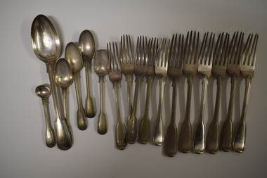 Warrnambool and District Historical Society Inc.
Functional object - Cutlery, George Rolfe, Mid to late 19th century
In 1854 in Melbourne George Rolfe Senior established an import business dealing in groceries, wines and spirits and tea. His son George, born in England, took over the business of Rolfe and Co in 1871. A keen sportsman, George Rolfe’s love of fishing led him to take frequent holidays in Warrnambool. He began buying blocks of land near the mouth of the Hopkins River in Warrnambool in the 1870s. By the 1880s Rolfe owned 50 acres in the Hopkins River area and named the property, Lyndoch. He built stables, chaff and bone sheds, a jetty, a boatshed, a water well, a windmill, a reservoir and extensive gardens. He also bought the nearby properties of Shipley and Fairy Hill, establishing a stud farm and breeding cattle. In 1891 he married Jane Ann Lake, the widow of his property manager, and when he died in 1919 his step-daughters, Florence and Annie Lake, inherited Lyndoch. The property was sold and became an aged care facility in 1952. The cutlery items were in use in the building erected by Florence Lake in 1920 and known today as Lyndoch but the ‘R’ monogram on the items suggest that they belonged to George Rolfe or even his father before him.These cutlery items are of considerable importance as mementoes of George Rolfe and his family. They were prominent in Warrnambool’s history in the late 19th and early 20th centuries with the establishment and development of the property, Lyndoch, near the mouth of the Hopkins River. These are 17 pieces from a silver cutlery set that belonged to the Rolfe family (one tablespoon, six large forks, five smaller forks, four small spoons and one mustard spoon.) All the pieces of cutlery have a monogrammed ‘R’ at the end of the handles. Twelve of the items are tarnished and one small spoon is very worn. All the items have six hallmarks. ‘R’george rolfe, lyndoch, warrnambool, rolfe & co. melbourne, florence lake, lyndoch warrnambool., history of warrnambool -
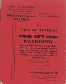 Bendigo Historical Society Inc.
Document - IAN DYETT COLLECTION: AUCTION CATALOGUE - WHITE SWAN RESERVOIR
Three auction catalogues, two with red covers and the third is missing the cover. Sale of Earth Moving Machinery. Spare Parts, Machine Tools, Motor Trucks, Engineering Plant, Concrete Mixing and Batching Plant, Air Compressor Plants, Buildings, Stores and Costly Equipment on 31st March to 5th April 1952 (inclusive) at the White Swan Reservoir, Ballarat, Victoria. J. H. Curnow & Son Pty. Ltd. Were the auctioneers. Included in the catalogue is a Locality Plan showing location of lot areas - access roads, etc. Page 4 has a black and white photo showing Super c Tournapull, Lot 63 and Tractor hauling 12-15 cub. Yd. capacity scoop. Page 9 photo is Lot 209, a Sheep's Foot Roller, Page 12 photo is Lots 258, 259 & 260 - Class 1 tractor hauling two 12-15 c yd Te Tourneau Scrapers, and page 68 has a black & white photo of Lot 2377, the Concrete Batching Plant.business, auctioneers, j h curnow & son pty ltd, ian dyett collection - auction catalogue - white swan reservoir, the ballarat water commissioners, j h curnow & son pty ltd, prahran telegraph printing co -
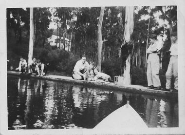 Southern Sherbrooke Historical Society Inc.
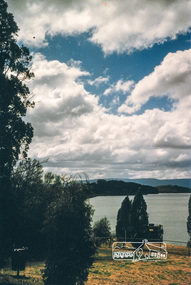
Photograph - People on the spillway of Belgrave Reservoir c.1940s
Black and white photo showing a group of people on the spillway of Belgrave Reservoir (at the time in the Belgrave Autocamp which is now called Belgrave Lake Park). The photo is taken from a person in a boat, the prow of which is visible at the bottom of the image. Three older boys are crouched to the left of the image. All are wearing shorts, shirts, and shoes with long socks, and two have pullovers. In the middle of the photo is a man with three children. The man is crouching. The children are in a huddle. To the right of the image are two adults standing on the spillway. The person on the right is male but the other's gender is uncertain. Between them and the children is what looks like a large portable radio. Behind the group is a heavily treed area which includes three or more white-trunked trees close to the spillway. In the distance is a white house with a verandah running across the front. This house belonged to Laura (surname unknown) before WW2. The house appears to be (now) 30 Judkins Ave.The photo has a white border and on the back is printed '1627'. It probably dates to the 1940s and is part of a collection of family photos donated by Pam Harris, Shire of Sherbrooke President, 1982-3 & 1987-1988. -
 Federation University Historical Collection
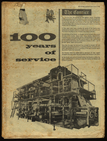
Newspaper, The Courier, 100 years of service, 1967, 10/06/1967
The newspaper was produced to celebrate the 100th year of the Ballarat Courier.96 page newspaper celebrating 100 years of publishing the Ballarat Courier Newspaper. Stories and images include: Robert Clark, Ballarat history, Sturt Street, Selkirk Bricks, Ballarat Industry, Thomas Bath, Royal Hotel, hotels, Begonia Festival, James Smith, Hollways, Myers, Ballarat Orphanage, Nazareth House, Lake Elsworth, Batches, libraries, Timken, Sunshine Biscuits, M.B. John, AMCAST, reservoirs, Ballarat Council,, Morsheads, Civic Hall, Alfred Hall, Art Gallery, Christies, 3BA, Paddle Bros, South Street, BTV 6, Memorial Theatre, Her Majesty's, Whitelaw-Monier, Coltman, costume, Messer and opie, politics, Dudley Erwin, Bill Stephen, Vance Dickie, Tom Evans, Murray Byrne, McKay - Macleod, Crockers, Ballarat Shire, Sovereign Hill. St Patrick's Cathedral, Christ Church Cathedral, Ballarat School of Mines, Mt Helen Campus, Ballarat Girls School. Ballarat North Technical School , Burke and Wills Memorial, Joe White Maltings, Ballarat Airport, Sunicrust, architecture, women, trams, transport, Faulls, Franklin Caravans, Olympics, football, history of Sunshine Biscuits robert clark, clark, ballarat, sturt street, selkirk bricks, industry, thomas bath, royal hotel, hotels, begonia festival, james smith, hollways, myers, ballarat orphanage, nazareth house, lake elsworth, batches, libraries, timken, sunshine biscuits, m.b. john, amcast, reservoirs, ballarat council, morsheads, civic hall, alfred hall, art gallery, christies, 3ba, paddle bros, south street, btv 6, memorial theatre, her majesty's, whitelaw-monier, coltman, costume, messer and opie, politics, dudley erwin, bill stephen, vance dickie, tom evans, murray byrne, mckay - macleod, crockers, ballarat shire, sovereign hill. st patrick's cathedral, christ church cathedral, ballarat school of mines, churches, mt helen campus, ballarat girls school. ballarat north technical school, burke and wills memorial, joe white maltings, ballarat airport, sunicrust, architecture, women, trams, transport, faulls, franklin caravans, olympics, football, bray raceway, coliseum motors, schoools, education, craig bros, dayelsford, clunes, beaufort, linton, skipton, heinz bors, villiers, flecnoe, jones, robertson, cowles, bulless, cronn, matthews, ballarat library, cowley's eureka iron works, john hollway and sons, ken webb, mayoral chain, ken flecknoe, a.e. flecknoe, bath's hotel, eureka stockade memorial park -
 Bendigo Historical Society Inc.
Document - ALBERT RICHARDSON COLLECTION: TAMBOUR MAJOR AND CHRISTMAS LINE OF REEF
Three page document. Front page, extracts from F. Chamber's Report on Tambour Major Shaft, includes reference to Allingham and Moore's shaft and Specimen Hill Reservoir. Early workings on the Christmas Reef line, Specimen Hill or Tambour Major, are listed in a table format, example - Great Western Gold Mining and Crushing Coy, 1855 Fajeon and Coy, 1859, tunnel in hillside. Specimen Hill Coy 1861 Indefatigable 1862, 64, 67 - 1881 Agamemnon 1862-1863 - 1881 Invincible Co. 1865 - 1867 Old Bendigo Tribute 140 ft 1870 Great Eastern Co 1870 - 1881 Great Eastern Tribute Co. Bismark Co, No. 1 North 150 ft 1870 - 1881 Bismark No. 2 Tribute 212 ft Allingham and Moore 338 ft 1872 Specimen Hill United 450 ft 1881 Great Western United (amalgamation of Old Bendigo, Invincible, Gt. Eastern and Bismark Coys) 400 ft 1882 Tambour Major 847 feet 1881 - 1890 Christmas Reef Co. 200 ft. 1895 - 1897 Open Cutsbendigo, mining, christmas reef gold mining -
 Eltham District Historical Society Inc
Photograph, Liz Pidgeon, Heritage Excursion; Maroondah Aqueduct, 3 September 2016, 3 September 2016
Newsletter No., 229, August 2016 Heritage Excursion - Maroondah Aqueduct Walk - Saturday 3rd September The Maroondah Aqueduct was once a major link in Melbourne’s water supply system. It was built between 1886 and 1891 to transfer water from the Watts River near Healesville to the Preston Reservoir. It was 66 km in length, made up of 41 km of open channel, 10 km of tunnel through hills and 15 km of pipeline across stream valleys known as inverted siphons. The section of the aqueduct through the Eltham area has been abandoned since the 1980s but the open channel has largely been retained. A recreational path follows the aqueduct reserve. For our excursion on 3rd September we intend to walk along the section of the aqueduct adjacent to Allendale Road. This is a section not visited on previous excursions and includes the transition from open channel to the inverted siphon across the Diamond Creek valley. Apart from the aqueduct itself the main feature of the walk is the extensive views across Eltham North and Diamond Creek. Along the way we will talk about the history of the aqueduct and the area. This easy walk is about 3 km return and will take 2 to 2.5 hours. It will start at 2pm at the junction of Allendale Road with Godber Road and Zig Zag Road North, officially Diamond Creek, but on the northern boundary of Eltham. (Melway ref.12 B10). Born Digitalmaroondah aqueduct, eltham north, activities, eltham district historical society, heritage excursion, acqueduct trail, sign -
 Eltham District Historical Society Inc
Photograph, Liz Pidgeon, Heritage Excursion; Maroondah Aqueduct, 3 September 2016, 3 September 2016
Newsletter No., 229, August 2016 Heritage Excursion - Maroondah Aqueduct Walk - Saturday 3rd September The Maroondah Aqueduct was once a major link in Melbourne’s water supply system. It was built between 1886 and 1891 to transfer water from the Watts River near Healesville to the Preston Reservoir. It was 66 km in length, made up of 41 km of open channel, 10 km of tunnel through hills and 15 km of pipeline across stream valleys known as inverted siphons. The section of the aqueduct through the Eltham area has been abandoned since the 1980s but the open channel has largely been retained. A recreational path follows the aqueduct reserve. For our excursion on 3rd September we intend to walk along the section of the aqueduct adjacent to Allendale Road. This is a section not visited on previous excursions and includes the transition from open channel to the inverted siphon across the Diamond Creek valley. Apart from the aqueduct itself the main feature of the walk is the extensive views across Eltham North and Diamond Creek. Along the way we will talk about the history of the aqueduct and the area. This easy walk is about 3 km return and will take 2 to 2.5 hours. It will start at 2pm at the junction of Allendale Road with Godber Road and Zig Zag Road North, officially Diamond Creek, but on the northern boundary of Eltham. (Melway ref.12 B10). Born Digitalmaroondah aqueduct, eltham north, activities, eltham district historical society, heritage excursion, acqueduct trail, diamond creek -
 Eltham District Historical Society Inc
Photograph, Liz Pidgeon, Heritage Excursion; Maroondah Aqueduct, 3 September 2016, 3 September 2016
Newsletter No., 229, August 2016 Heritage Excursion - Maroondah Aqueduct Walk - Saturday 3rd September The Maroondah Aqueduct was once a major link in Melbourne’s water supply system. It was built between 1886 and 1891 to transfer water from the Watts River near Healesville to the Preston Reservoir. It was 66 km in length, made up of 41 km of open channel, 10 km of tunnel through hills and 15 km of pipeline across stream valleys known as inverted siphons. The section of the aqueduct through the Eltham area has been abandoned since the 1980s but the open channel has largely been retained. A recreational path follows the aqueduct reserve. For our excursion on 3rd September we intend to walk along the section of the aqueduct adjacent to Allendale Road. This is a section not visited on previous excursions and includes the transition from open channel to the inverted siphon across the Diamond Creek valley. Apart from the aqueduct itself the main feature of the walk is the extensive views across Eltham North and Diamond Creek. Along the way we will talk about the history of the aqueduct and the area. This easy walk is about 3 km return and will take 2 to 2.5 hours. It will start at 2pm at the junction of Allendale Road with Godber Road and Zig Zag Road North, officially Diamond Creek, but on the northern boundary of Eltham. (Melway ref.12 B10). Born Digitalmaroondah aqueduct, eltham north, activities, eltham district historical society, heritage excursion, acqueduct trail, sign -
 Eltham District Historical Society Inc
Photograph, Liz Pidgeon, Heritage Excursion; Maroondah Aqueduct, 3 September 2016, 3 September 2016
Newsletter No., 229, August 2016 Heritage Excursion - Maroondah Aqueduct Walk - Saturday 3rd September The Maroondah Aqueduct was once a major link in Melbourne’s water supply system. It was built between 1886 and 1891 to transfer water from the Watts River near Healesville to the Preston Reservoir. It was 66 km in length, made up of 41 km of open channel, 10 km of tunnel through hills and 15 km of pipeline across stream valleys known as inverted siphons. The section of the aqueduct through the Eltham area has been abandoned since the 1980s but the open channel has largely been retained. A recreational path follows the aqueduct reserve. For our excursion on 3rd September we intend to walk along the section of the aqueduct adjacent to Allendale Road. This is a section not visited on previous excursions and includes the transition from open channel to the inverted siphon across the Diamond Creek valley. Apart from the aqueduct itself the main feature of the walk is the extensive views across Eltham North and Diamond Creek. Along the way we will talk about the history of the aqueduct and the area. This easy walk is about 3 km return and will take 2 to 2.5 hours. It will start at 2pm at the junction of Allendale Road with Godber Road and Zig Zag Road North, officially Diamond Creek, but on the northern boundary of Eltham. (Melway ref.12 B10). Born Digitalmaroondah aqueduct, eltham north, activities, eltham district historical society, heritage excursion, acqueduct trail -
 Eltham District Historical Society Inc
Photograph, Liz Pidgeon, Heritage Excursion; Maroondah Aqueduct, 3 September 2016, 3 September 2016
Intersection with local Street signs Newsletter No., 229, August 2016 Heritage Excursion - Maroondah Aqueduct Walk - Saturday 3rd September The Maroondah Aqueduct was once a major link in Melbourne’s water supply system. It was built between 1886 and 1891 to transfer water from the Watts River near Healesville to the Preston Reservoir. It was 66 km in length, made up of 41 km of open channel, 10 km of tunnel through hills and 15 km of pipeline across stream valleys known as inverted siphons. The section of the aqueduct through the Eltham area has been abandoned since the 1980s but the open channel has largely been retained. A recreational path follows the aqueduct reserve. For our excursion on 3rd September we intend to walk along the section of the aqueduct adjacent to Allendale Road. This is a section not visited on previous excursions and includes the transition from open channel to the inverted siphon across the Diamond Creek valley. Apart from the aqueduct itself the main feature of the walk is the extensive views across Eltham North and Diamond Creek. Along the way we will talk about the history of the aqueduct and the area. This easy walk is about 3 km return and will take 2 to 2.5 hours. It will start at 2pm at the junction of Allendale Road with Godber Road and Zig Zag Road North, officially Diamond Creek, but on the northern boundary of Eltham. (Melway ref.12 B10). Born Digitalmaroondah aqueduct, eltham north, activities, eltham district historical society, heritage excursion, street signs, acqueduct trail, allendale rd, godber rd, zig zag road, intersection -
 Eltham District Historical Society Inc
Photograph, Liz Pidgeon, Heritage Excursion; Maroondah Aqueduct, 3 September 2016, 3 September 2016
Newsletter No., 229, August 2016 Heritage Excursion - Maroondah Aqueduct Walk - Saturday 3rd September The Maroondah Aqueduct was once a major link in Melbourne’s water supply system. It was built between 1886 and 1891 to transfer water from the Watts River near Healesville to the Preston Reservoir. It was 66 km in length, made up of 41 km of open channel, 10 km of tunnel through hills and 15 km of pipeline across stream valleys known as inverted siphons. The section of the aqueduct through the Eltham area has been abandoned since the 1980s but the open channel has largely been retained. A recreational path follows the aqueduct reserve. For our excursion on 3rd September we intend to walk along the section of the aqueduct adjacent to Allendale Road. This is a section not visited on previous excursions and includes the transition from open channel to the inverted siphon across the Diamond Creek valley. Apart from the aqueduct itself the main feature of the walk is the extensive views across Eltham North and Diamond Creek. Along the way we will talk about the history of the aqueduct and the area. This easy walk is about 3 km return and will take 2 to 2.5 hours. It will start at 2pm at the junction of Allendale Road with Godber Road and Zig Zag Road North, officially Diamond Creek, but on the northern boundary of Eltham. (Melway ref.12 B10). Born Digitalmaroondah aqueduct, eltham north, activities, eltham district historical society, heritage excursion, acqueduct trail