Showing 6434 items matching "robinvale-aboriginal community. | housing-aborignal"
-
 Victorian Aboriginal Corporation for Languages
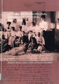
Book, Elizabeth Nelson, Letters from Aboriginal women of Victoria, 1867-1926, 2002
This edited collection of women's correspondence constitutes an important historical record of the experiences of Aboriginal women during a crucial period of social change. In particular the letters are valuable for the insight they offer into the impact on Aboriginal communities of government legislation and mission policies and the women's assertion of their entitlement to freedom and agency. Written by 81 different women, the letters cover such issues as children, family, religion, land, housing and material assistance.maps, b&w photographsvictorian aboriginal women, correspondence, government policy -
 Surrey Hills Historical Society Collection
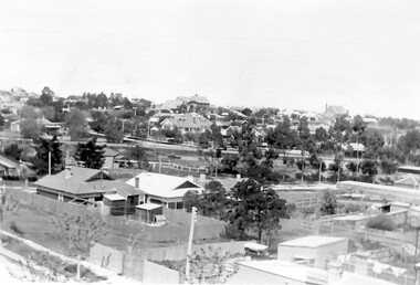
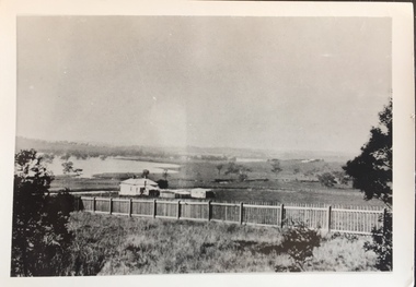
Photograph, Surrey Hills looking south-east from the steeple of Holy Trinity Church, 1921, 1921
The property in the foreground is 'Edgeware' at 171 Union Road, a house built by the Zeplin family. It became the home / residence of Dr Percy Liddle and later Dr James Landells Blakie. By the time this photo was taken Dr Blakie had moved across the road to 174 Union Road. In the background behind the 2 houses in the foreground is the Surrey Hills Stationmaster's house, sitting behind a picket fence. The Alan Holt register gives a build date of c1915 for this house, which fits stylistically. The first stationmaster was probably Michael Ginnane, who stayed in the area after he retired, moving to 1 Russell Street. This property was listed as 8 Bedford Avenue, the only house on the south side of the road. It was demolished in c1972 to make way for widening of the rail track with a third line. The photographer Norman Carter took many photos of Surrey Hills and Mont Albert from the 1920s, in particular of events and activities associated with the Church of England.Black and white photo taken from the steeple of Holy Trinity Church looking across housing towards the railway line and Albany / Windsor Crescents and on towards Canterbury Road. Surrey Hills Primary School and St Stephens Presbyterian Church feature prominently on the horizon. The stationmaster's cottage is centre left adjacent to a large conifer-like tree, with a white fence delineating the railway yards.On back of original: "6-11-21" and in a different hand in biro: "from tower of Holy Trinity Church"albany crescent, windsor crescent, st stephens presbyterian church, surrey hills primary school, railways, stationmasters' houses, bedford avenue, norman carter, edgeware, dr percy liddle, dr james blakie -
 Bendigo Historical Society Inc.
Document - VICTORIA HILL - BENDIGO BRANCH HISTORICAL SOCIETY - MINE TOUR
Typed notes for a tour of the area. Areas mentioned are: Hospital Hill, The Central Deborah Mine, New Chum Railway Mine, The Rocks, New Chum Hill, Victoria Hill, Central Nell Gwynne, Rae's Open Cut, Housing Commission Homes and Latham and Watson's. Description of machinery at the Central Deborah Mine, yields, dividends, depth of shafts and directions to get ot the various places is included.document, gold, victoria hill, bendigo branch historical society mine tour, all saints church, joseph la trobe, bendigo's first hospital, sacred heart cathedral, the central deborah mine, city council, londonderry west shaft, new red, white and blue consolidated (big blue), a roberts & sons, big deborah, the new golden fleece, new chum goldfields, central wattle gully mine chewton, virginia consols, black's quarries coldstream, thompson's engineering and pipe co ltd castlemaine, new chum railway mine, golden square methodist church, the rocks, e j dunn, gold monument, shamrock mine, mt alvernia hospital, j b lazarus, john brown knitwear factory, gold fmines hotel, david sterry, new chum hill, fortuna villa, geo lansell, theodore ballerstedt, a h q survey regiment headquarters, old chum mine, central nell gwynne, rae's open cut, theodore ballerstedt, new chum syncline, little 180 mine, victoria quartz, wittcheibe's 'jeweller's shop', adventure, advance, cinderella, j n macartney, bendigo goldfields registry 1870, wm rae, johnson's devonshire mine, snobs hill mine, ellenborough mullock heap, belmont mullock heap, sadowa, st mungo, united devonshire, mechanic's institute, log lock-up, court house, j b watson, housing commission homes, hustlers hill, latham and watsons', the great extended hustlers, a richardson -
 Bendigo Military Museum
Document - GENERAL INFORMATION FOR NATIONAL SERVICE DISCHARGE
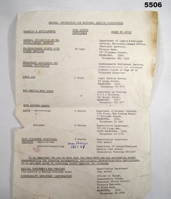
Ref Cat No.754. Form shows contact points for various categories of service, i.e. Legal Aid, Housing Loans, Pensions etc, that the National Service may have a right to, also shows time limits that may apply.Single sheet white paper A.4 size with tattered bottom edge with general information that may be required on discharge. Writing only on one side.Against line "Advise and Counselling" written in blue pen "Brian Dorizzi C627117".national service, discharge information. -
 Hume City Civic Collection
Photograph, Early 1970s
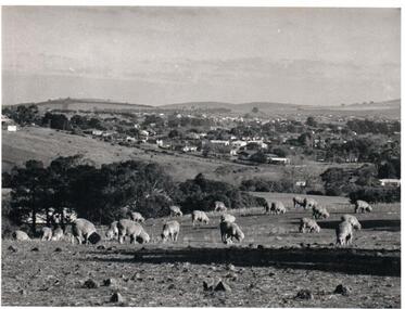
The photograph was taken when Sunbury township did not extend far beyond Anderson Road to the west and Powlett Street to the east. The Paynes housing development can be seen scattered across the hillside between Gap Road and Mitchells Lane.A black and white photograph of a panoramic view of Sunbury township looking west and taken from above the Goonawarra Winery. Sheep are grazing on the hilside in the foreground.sunbury township, goonawarra winery, george evans collection -
 Whitehorse Historical Society Inc.
Document, Cootamundra Ward, July 2024
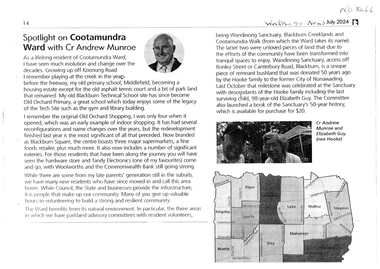
Cr Andrew Munroe reminisces over changes in Cootamundra Wardnon-fictionCr Andrew Munroe reminisces over changes in Cootamundra Wardblackburn square, old orchard shopping centre blackburn, middlefield primary school no.4878, wandinong sanctuary, blackburn technical school, blackburn creekland, old orchard primary school no.3130, cootamundra walk, munroe andrew cr -
 City of Kingston
Photograph - Black and white, 5 January 1984
Cheltenham and Heatherton are suburbs in the City of Kingston that were originally established as a rural market gardening community. The market gardens, farms and paddocks have gradually been sub-divided into housing and industrial estates and associated infrastructure such as schools and shopping facilities. This aerial image covers a diverse section of the City of Kingston, taking in the suburbs of Cheltenham, Heatherton, Mentone and Parkdale. By 1984, the market gardens of the district have been replaced by housing and factories. The Nylex factory is visible and now closed. Mentone Bowl on the corner of Warrigal Road and Nepean Highway has now been replaced by high rise apartments, another feature of the changing landscape in the City of Kingston. The vacant land now occupied by the Moorabbin Airport Direct factory Outlet (DFO) is also depicted.Aerial photograph of Cheltenham, Heatherton, Mentone and Parkdale within the City of Kingston. The area depicted in the 1984 aerial view includes Centre Dandenong Road and Cheltenham East Primary School (top left), Kingston Heath Reserve (top right), intersection of Lower Dandenong Road, Warrigal Road, Balcombe Road and Nepean Highway (bottom left), Balmoral Drive/McSwain Street Parkdale (bottom right).White text: 3831-179 Lens information [indecipherable] RINGWOOD M/S 7922-3 RUN 16 [Clockface image] 5,300' ASL VIC DLS© 5-1-84cheltenham, heatherton, mentone, parkdale, market gardens, urbanisation -
 Bendigo Historical Society Inc.
Document - CEPA COLLECTION: LETTER FROM DEPARTMENT OF AGRICULTURE VICTORIA
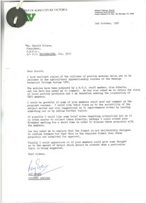
Letter from the President of the Department of Agriculture, Victoria providing the outline of modules to be included in the Agricultural Apprenticeship courses at the Bendigo Technical College during 1982 Letter dated 2nd October 1981 Four modules: A70 Poultry Housing, 3 pages A71 Poultry Nutrition and Feeding, 3 pages A72 Poultry Flock Husbandry and Disease Control, 3 pages A73 Breeding Poultry, 3 pages -
 Hume City Civic Collection
Directory, Shire of Bulla Directory, 1994 - 1995
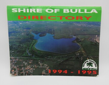
The Directory was published by the former Shire of Bulla in 1994 - 1995 and was issued to residentsa living withing the Shire. It features details of public services which were available within the area at the time as well as maps of the settlements and some private advewrtisements.A 20 page booklet with an aerial photograph of the Greenvale Dam and surrounding area on the front cover. A green strip is along the spine of the booklet with the words 'Shire of Bulla' printed in white and 'Directory' printed in red. '1994 - 1995' is printed in red across the bottom of the front cover and the Shire of Bulla - 'City Living . Country Style' logo is in the bottom RH corner. The back cover features an advertisement for the Roxburgh housing development.shire of bulla, directory, sunbury, bulla, attwood hill, craigieburn, george evans collection -
 Ballarat Tramway Museum
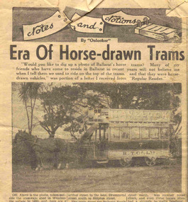
Newspaper, The Courier Ballarat, "Era of Horse-drawn Trams", 29/07/1950 12:00:00 AM
Newspaper clipping from The Courier, Ballarat, Sat. 29/7/1950, titled "Era of Horse-drawn Trams", in the "note and Notions" column prepared by "Onlooker". Has a photo of No. 7 in Wendouree Parade, outside the depot. Gives an history of the horse trams, routes, operations, tickets, housing, "Tramway Row", wages and closing. Has advertisements for Woodmason Trading Co (Paint sale) and Commonwealth bank on the same sheet.horse trams, wages, housing, operations -
 Greensborough Historical Society
Magazine, Banyule Banner January 2024, 2024_01
The Banyule Banner is published by Banyule Council to advertise upcoming events in the City of Banyule and to report on past events. This edition contains reports on aquatic fun an safety, Kinder open days, new social housing in Bellfield, council services and community events.A record of events within the City of Banyule.24 pages, colour illustrations. banyule banner, banyule council -
 Bendigo Military Museum
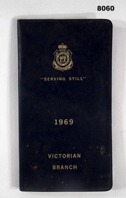
Accessory - DIARY, RSL VICTORIA 1969, Victorian RSL State Branch, C. late 1968
The pages of written text cover everything the RSL does from welfare, commemorative, legal aid, membership, women's auxiliary and housing to name a few. Bert Pollard was an active RSL Member involved in Committee and the District Board. He served in WW2.Diary black plastic covers with gold text on front cover, top has the RSL logo followed by "Serving Still - 1969 - Victorian Branch", inside first page are details re Anzac House Melbourne, there are 28 pages of written text, page for members personal details, 4 blank pages for notes, the Calendar itself folds out for viewing and to enter notes, last page has a 12 month calendar. "Bert Pollard, phone 5433741"brsl, smirsl, diary -
 Ringwood and District Historical Society
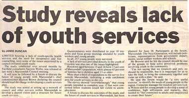
Newspaper, Scrapbook Clipping, Library Collection, Ringwood, Victoria, `
``Newspaper clipping from "The Mail", 21-5-96 P3. Study reveals lack of youth services. By JAMIE DUNCAN Limited housing, a lack of youth-specific health services and the need for inexpensive and free counselling, were some of the issues uncovered by a council-initiated youth study. It will now be follwed by a forum to discuss the future of young people with Maroondah's chief commissioner Moreton Brown declaring the council should lead the charge in developinfg a youth services plan.` -
Ringwood and District Historical Society
Contracts, Acquisition of the land in Grey Street and Ware Crescent, Ringwood East by the Graduates Assoc. of the Kindergarten Training College, Melbourne. 1950-1960, 1950-1960
Various papers from the titles Office, City of Ringwood Solicitors for accounts on the purchase of the land by the Graduates of the Kindergarten Training College and caveats pertaining to the land. This was the site of the Warrawong day and residential care kindergarten which was demolished c.2000 to be divided into housing blocks.18 pages of documents relating to the acquisition of the land in Grey Street and Ware Crescent, Ringwood East by the Graduates Assoc. of the Kindergarten Training College, Melbourne. -
 Greensborough Historical Society
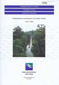
Pamphlet, Lower Plenty River concept plan, summary report: Maroondah Pipetrack to Yarra River, 1992_07
This draft concept plan covers the lower Plenty River from the Maroondah Pipe track in Greensborough to where the Plenty meets the Yarra. Melbourne Water was the lead agency, assisted by the Shires of Eltham and Diamond Valley, City of Heidelberg, the EPA and Department of Planning and Housing.Coloured pamphlet, photograph and plans 12 pages. 2 copies.plenty river, maroondah aqueduct, melbourne water -
 Kew Historical Society Inc
Photograph - Yarra in Flood - Belford & Kilby Farms, 1903
The Yarra Valley in what was previously called North Kew, but is now East Kew, was frequently subjected to flooding. Apart from some development on higher ground, the City of Kew regularly introduced restrictions on development and the building of housing in the area because of flood levels. Panoramic photographic positive of North Kew where the Belford and Kilby Farms were located on the south side of the Yarra River. This photo is a copy of the original photo in the collection.floods -- yarra -- 1903, kew golf course, greenacres golf course -
 Whitehorse Historical Society Inc.
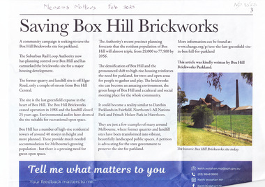
Article, Saving Box Hill Brickworks, Feb 2025
A community campaign is seeking to save the Box Hill Brickworks site for parkland.non-fictionA community campaign is seeking to save the Box Hill Brickworks site for parkland.suburban rail loop authority, box hill brickworks, wolahan keith mp -
 Eltham District Historical Society Inc
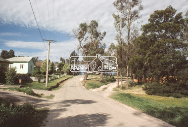
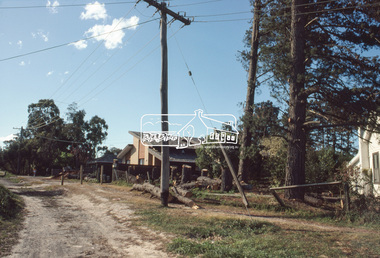
Slide, View looking northeast to turnabout near 10 McCarthy Grove, Montmorency, c.Oct. 1980
One of a series of images of roads and infrastructure taken by Eltham Shire Council Planning and Engineering officers. They provide perspective of the changes in housing styles and road development that began sweeping in from the mid 1970s with increasing urbanisation of what was once more outlying suburbs and regions.35 mm colour positive transparency Mount - Kodak Kodachrome CardProcessed Oct 1980houses, infrastructure, mccarthy grove, montmorency, roads -
 Eltham District Historical Society Inc
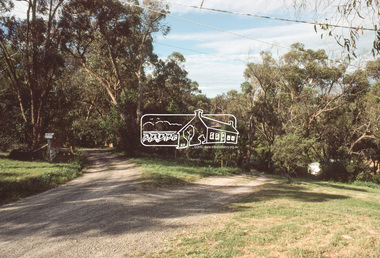
Slide, McCarthy Grove, Montmorency, extended driveway from Main Road, c.Oct. 1980
One of a series of images of roads and infrastructure taken by Eltham Shire Council Planning and Engineering officers. They provide perspective of the changes in housing styles and road development that began sweeping in from the mid 1970s with increasing urbanisation of what was once more outlying suburbs and regions.35 mm colour positive transparency Mount - Kodak Kodachrome CardProcessed Oct 1980houses, infrastructure, mccarthy grove, montmorency, roads -
 Eltham District Historical Society Inc
Slide, View looking southwest to turnabout near 9 McCarthy Grove, Montmorency, c.Oct. 1980
One of a series of images of roads and infrastructure taken by Eltham Shire Council Planning and Engineering officers. They provide perspective of the changes in housing styles and road development that began sweeping in from the mid 1970s with increasing urbanisation of what was once more outlying suburbs and regions.35 mm colour positive transparency Mount - Kodak Kodachrome CardProcessed Oct 1980houses, infrastructure, mccarthy grove, montmorency, roads -
 Eltham District Historical Society Inc
Slide, McCarthy Grove, Montmorency looking west near No. 27, c.Oct. 1980
One of a series of images of roads and infrastructure taken by Eltham Shire Council Planning and Engineering officers. They provide perspective of the changes in housing styles and road development that began sweeping in from the mid 1970s with increasing urbanisation of what was once more outlying suburbs and regions.35 mm colour positive transparency Mount - Kodak Kodachrome CardProcessed Oct 1980houses, infrastructure, mccarthy grove, montmorency, roads -
 Eltham District Historical Society Inc
Slide, McCarthy Grove, Montmorency looking east towards Reichelt Avenue, near no. 27, c.Oct. 1980
One of a series of images of roads and infrastructure taken by Eltham Shire Council Planning and Engineering officers. They provide perspective of the changes in housing styles and road development that began sweeping in from the mid 1970s with increasing urbanisation of what was once more outlying suburbs and regions.35 mm colour positive transparency Mount - Kodak Kodachrome CardProcessed Oct 1980houses, infrastructure, mccarthy grove, montmorency, roads -
 Eltham District Historical Society Inc
Slide, Quinn Estate, McCarthy Grove ext. driveway, Montmorency, near no. 31, c.Oct. 1980
One of a series of images of roads and infrastructure taken by Eltham Shire Council Planning and Engineering officers. They provide perspective of the changes in housing styles and road development that began sweeping in from the mid 1970s with increasing urbanisation of what was once more outlying suburbs and regions.35 mm colour positive transparency Mount - Kodak Kodachrome CardProcessed Oct 1980houses, infrastructure, mccarthy grove, montmorency, roads -
 Eltham District Historical Society Inc
Slide, Looking towards 99 Buena Vista Drive, Montmorency, c.Oct. 1980
One of a series of images of roads and infrastructure taken by Eltham Shire Council Planning and Engineering officers. They provide perspective of the changes in housing styles and road development that began sweeping in from the mid 1970s with increasing urbanisation of what was once more outlying suburbs and regions.35 mm colour positive transparency Mount - Kodak Kodachrome CardProcessed Oct 1980houses, infrastructure, mccarthy grove, montmorency, roads -
 Whitehorse Historical Society Inc.
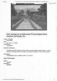
Document - Various including photos, newspaper items, Hethersett Private Repatriation Hospital, Burwood, 1866 - 1943
Between 1915 - 1917 Dr Ramsay Mailer and members of his family ran the 30 bed Hethersett Voluntary Military Hospital in Burwood for5 returned shell shocked and fatigued soldiers at his own expense. This property became part of the Presbyterian Ladies College in1939.A4 Print outs from blogspot, Trove (SLV), and newspaper obituariesnon-fictionBetween 1915 - 1917 Dr Ramsay Mailer and members of his family ran the 30 bed Hethersett Voluntary Military Hospital in Burwood for5 returned shell shocked and fatigued soldiers at his own expense. This property became part of the Presbyterian Ladies College in1939. mailer ramsay dr, world war 1914-1918, housing reform 1920s, camp mailer, hospitals, repatriation care -
 Sunbury Family History and Heritage Society Inc.
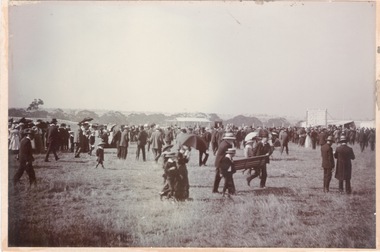
Photograph, Sunbury Racecourse
The photograph was taken at a Sunbury Race meeting, when a sudden shower of rain caused the spectators to run for cover. Sunbury Race Course was situated along Racecourse Road about 2kms from the railway station. The land has been sold and it is now a housing estate. The race meetings in Sunbury were well attended with special trains running from Melbourne on race days.A noon-digital sepia photograph mounted on cardboard of a crowd of people caught in a sudden shower of rain and running for shelter at a race meeting.sunbury race meetings, racecourse road, races, stud farms -
 Bendigo Military Museum
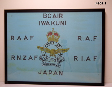
Banner - BCOF BANNERS, FRAMED, c1946 - Frame 2022
1. "I.W.A. KUNI" - City in Japan. 2. " B.C.O.F." - Japan 1946-48. British Commonwealth Occupation Forces (Japan).1. Banner - framed cotton fabric, light blue background with screen printing in black colour letters and centre unit insignia black, yellow and red colours. 2. Banner - framed cotton fabric, white background with screen printing in black colour letters and centre unit insignia red, yellow and blue colours. 1. & 2. Frames - timber, black colour paint, glass front, timber housing.Screen printing - black ink. 1. "BCAIR/IWA KUNI/ R.A.A.F./R.A.F./ R.N.2.A.F./R.I.A.F./JAPAN " Unit insignia 'ROYAL AUSTRALIAN AIR FORCE' 2. " R.A.N./H.M.A. SHIPS/ B.C.O.F./ AUSTRALIA - JAPAN/1946-1948"military, ww2, japan, banners -
 Bendigo Historical Society Inc.
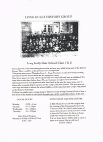
Document - LONG GULLY HISTORY GROUP COLLECTION: LONG GULLY HISTORY GROUP
Page advertising The Long Gully History Group which meets every Thursday from 1 - 3 pm. They aim to write a book specifically on Long Gully and have it published. The is an invitation for people to come during Housing Week. House Hours and After School Program are mentioned. Also mentioned is the Long Gully Aquatic Centre. A black and white photo of the Long Gully State School Class 1 & 2 is attached.bendigo, history, long gully history group, the long gully history group - long gully history group, long gully state school class 1 & 2, long gully swimming pool -
Ballarat Tramway Museum
Newspaper, The Courier Ballarat, "Tram depot site to be auctioned", 5/05/1972 12:00:00 AM
Newspaper clipping from The Courier, Ballarat, dated Friday 5/5/1972 titled "Tram depot site to be auctioned". Item advising that the SEC Tram depot is to be sold in one lot, following an announcement in Parliament by Mr. Tom Evans MLA and that the decision to auction the site replaces the SEC proposal for an architect designed housing scheme. One of a large group of newspaper cuttings from John Bainbridge, 7/4/02.sec depot, sale of sec depot -
 Maldon Vintage Machinery Museum Inc
Motor Mower, Maker's name "Charles H Pugh"
Green painted cylindrical lawn mower with rear roller, pull start and no catcher. Regal coat of arms on front housing signifying maker is official motor mower supplier to the Queen. Rectangular petrol tank mounted between the handles above the engine. Small wooden roller in two parts on front. Pale grey plastic cover on starter mechanism. Height adjustment on front roller. Engine controls on right handle.Possibly "Eureka" model.machinery, cylinder motor mower