Showing 1857 items matching "subdivision"
-
 Whitehorse Historical Society Inc.
Pamphlet, Blackburn bellbird area, 1986
Pamphlet on proposal to extend planning controls over buildings, subdivision and tree removal introduced in 1985.Pamphlet on proposal to extend planning controls over buildings, subdivision and tree removal introduced in 1985. Now these controls are proposed to extend over a further 53 streets in Blackburn's 'Bellbird Area'.Pamphlet on proposal to extend planning controls over buildings, subdivision and tree removal introduced in 1985. town planning, victoria. department of planning and environment, blackburn -
 Kew Historical Society Inc
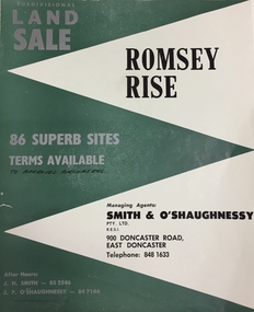
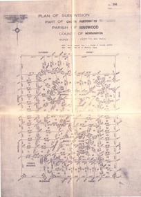
Plan - Subdivision Plan, Romsey Rise, Doncaster East
Real estate brochure for a land sale of 86 sites in East Doncaster. Roads identified in the plan include: George Street, Dennert Street, Worthing Avenue, Sandhurst Street, Belinda Crescent, and Romsey Rise.Historic subdivision plan of a Doncaster East EstateFour page colour real estate brochure including on page 2 a subdivision plan for the Romsey Rise estate in East Doncaster. This record also includes a separate price list for the lots.real estate plans, subdivision plans - doncaster east, romsey rise estate - doncaster east (vic) -
 Lakes Entrance Historical Society
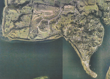
Photograph - Metung, Gippsland Ports, 2006 c
Colour aerial photograph showing Shaving Point at Metung including Chinamans Creek at the right housing subdivisions of Kingscove Estate Tambo Bluff Estate and Lake King on Gippsland Lakes Victoriaaerial photograph, topography, waterways, metung -
 Kew Historical Society Inc
Plan - Subdivision Plan, St Helliers Estate, Kew, circa 1910, c.1910
Pru Sanderson, in her groundbreaking ‘City of Kew Urban Conservation Study : Volume 2 - Development History’ (1988), summarised the periods of urban development and subdivisions of land in Kew. The periods that she identified included 1845-1880, 1880-1893, 1893-1921, 1921-1933, 1933-1943, and Post-War Development. These periods were selected as they represented periods of rapid growth or decline in urban development. An obvious starting point for Sanderson’s groupings involved population growth and the associated economic cycles. These cycles also highlighted urban expansion onto land that was predominantly rural, although in other cases it represented the decline and breakup of large estates. A number of the plans in the Kew Historical Society’s collection can also be found in other collections, such as those of the State Library of Victoria and the Boroondara Library Service. A number are however unique to the collection.Subdivision plans are historically important documents used as evidence of the growth of suburbs in Australia. They frequently provide information about when the land was sold on which a built structure was subsequently constructed as well as evidence relating to surveyors and real estate and financial agents. The numerous subdivision plans in the Kew Historical Society's collection represent working documents, ranging from the initial sketches made in planning a subdivision to printed plans on which auctioneers or agents listed the prices for which individual lots were sold. In a number of cases, the reverse of a subdivision plan in the collection includes a photograph of a house that was also for sale by the agent. These photographs provide significant heritage information relating house design and decoration, fencing and household gardens.In the subdivision of part of Crown Portion 82, bordered by John and Sackville Streets and Cotham and Burke Roads, over 100 lots were offered for sale. In addition to the designated lots, a number of key locations are also identified. These include the Genazzano Convent to the north of Cotham Road, the Reservoir, St Hilary’s and the land holding of Colonel Parnell on the corner of John Street and Cotham Road. On the Plan, No. 5064, is the handwritten name ‘St. Hellier’s Estate’. St. Helliers, the home of the Dumaresq family is shown beside St. Hilary’s.subdivision plans - kew, st helliers estate -
 Kew Historical Society Inc
Photograph - 29 Uvadale Grove, Kew, 1920
The numerous subdivision plans in the Kew Historical Society's collection represent working documents, ranging from the initial sketches made in planning a subdivision to printed plans on which auctioneers or agents listed the prices for which individual lots were sold. In a number of cases, the reverse of a subdivision plan in the collection includes a photograph of a house that was also for sale by the agent. Subdivision plans are historically important documents used as evidence of the growth of suburbs in Australia. They frequently provide information about when the land was sold on which a built structure was subsequently constructed as well as evidence relating to surveyors and real estate and financial agents. These photographs provide significant heritage information relating house design and decoration, fencing and household gardens.When 29 Uvadale Grove, Kew was offered for sale it was described as: ‘Kew. Fine locality, 3 minutes Cotham Road. Splendidly built 6 roomed Brick Villa. Rooms 17 x 14, 16 x 13, &c. Beautifully fitted throughout. Land 70 x 134 to ROW.’ The price was advertised as being £1,400. The house exhibits key features of Federation architecture such as the gabled roof with a facing of half-timber and stucco. The veranda has a curved corrugated iron roof supported by timber pillars and fretwork. The slate roof with terra cotta ridging and finials marks a transition to the more common use of Marseilles tiles in Federation architecture.subdivisions - kew (vic.), 29 uvadale grove - kew (vic.) -
Ringwood and District Historical Society
Brochure, Farros Falcon Press, Heathmont Station Estate Pamphlet incl sub division plan (undated0, Not Known
Promotional brochure from estate agents H. C. Costello & Co Auctioneers for the Heathmont Station Estate: 140 beautiful home sites.Large buff coloured bifold pamphlet advertising Heathmont Station Estate. Red and black printing; photo on front and back; subdivision plan inside. +Additional Keywords: Costello, H. C. & Co. -
 Ringwood and District Historical Society
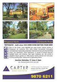
Memorabilia - Property History, Rothsaye, 2 Unsworth Road Ringwood North, Victoria
"Rothsaye" was built in 1917 by J.B. McAlpin who was a councillor in Lillydale and Ringwood and was Mayor in 1928-29.Multi pocket burgundy coloured spiral binder containing 34 pages of the property history, subdivisions, land titles and photographs of the house, compiled by Richard Carter pre-auction 17 June 2006 -
 Kew Historical Society Inc
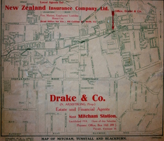
Map - Street Map, R L Jarrett, Map of Mitcham, Tunstall and Blackburn, 1929
Tunstall was originally the name of Nunawading Railway Station. Tunstall opened on 4 June 1888 and was renamed on 1 November 1945. An historically significant advertising map that can be used to ascertain the extent of urban development in 1929 in the areas of Nunawading, Blackburn and Mitcham.A map of Mitcham, Tunstall and Blackburn found on the reverse of a real estate subdivision plan published by R. L. Jarrett of Elizabeth Street. This promotional street map is overprinted with the business address of the sponsors and advertising. Map overlaid in red print: "Drake & Co. / (N. Armstrong, Prop.) / Estate and Financial Agents / next Mitcham Station / Established 1914. Open all day Saturday. / Phones: Office, Box Hill 289 J. / Private, Vermont 10."real estate agents, mitcham, tunstall, blackburn, road maps, drake & co, new zealand insurance co ltd -
 Kew Historical Society Inc
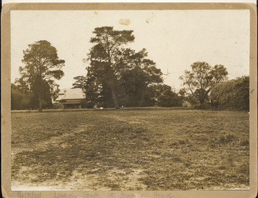
Photograph, 'Parkhill', Kew
This is the earliest known photograph of the home of Thomas Judd, now situated at 20 Hillcrest Avenue, but with an address in Parkhill Road before surrounding subdivisions were created. Thomas Judd was a notable early colonist in Kew.Silver albumen photograph on card of the house and paddock of Parkhill, the home of the Kew pioneer Thomas Judd. The photograph looks south up towards the house. The photograph is undated but it is presumed to predate the subdivision of 1915."Parkhill. Looking South up towards House"thomas judd, kew - history of, parkhill, kew -- pioneers -
 Kew Historical Society Inc
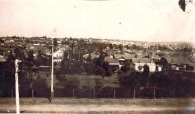
Photograph - Panoramic view of Kew East, 1927
This is one of two photographs of the same view in the collection. The other purports to be taken in 1925 whereas this photo has an inscription dating it to 1927. East Kew was the last section of Kew to be developed following subdivision of the large estates and former farmland in the first half of the twentieth century. The centre of the photograph would appear to show the trees of the Boroondara cemetery.Inscribed verso: "East Kew 1927" kew east (vic.), panoramic photos -- kew (vic.) -
 Kew Historical Society Inc
Plan - Subdivision Plan, Normanby Estate, East Kew, 1913
Pru Sanderson, in her groundbreaking ‘City of Kew Urban Conservation Study : Volume 2 - Development History’ (1988), summarised the periods of urban development and subdivisions of land in Kew. The periods that she identified included 1845-1880, 1880-1893, 1893-1921, 1921-1933, 1933-1943, and Post-War Development. These periods were selected as they represented periods of rapid growth or decline in urban development. An obvious starting point for Sanderson’s groupings involved population growth and the associated economic cycles. These cycles also highlighted urban expansion onto land that was predominantly rural, although in other cases it represented the decline and breakup of large estates. A number of the plans in the Kew Historical Society’s collection can also be found in other collections, such as those of the State Library of Victoria and the Boroondara Library Service. A number are however unique to the collection.The Kew Historical Society collection includes almost 100 subdivision plans pertaining to suburbs of the City of Melbourne. Most of these are of Kew, Kew East or Studley Park, although a smaller number are plans of Camberwell, Deepdene, Balwyn and Hawthorn. It is believed that the majority of the plans were gifted to the Society by persons connected with the real estate firm - J. R. Mathers and McMillan, 136 Cotham Road, Kew. The Plans in the collection are rarely in pristine form, being working plans on which the agent would write notes and record lots sold and the prices of these. The subdivision plans are historically significant examples of the growth of urban Melbourne from the beginning of the 20th Century up until the 1980s. A number of the plans are double-sided and often include a photograph on the reverse. The Normanby Estate, which was adjacent to Normanby Road, Kew East, included thirty-one lots for sale. Streets on the subdivision plan include Adeney Avenue, Park Hill Road, Normanby Road, Weir Street and Wharton Street. Cotham Road and its tramway are shown nearby. The plan is interesting as it shows Wharton Street, named after the architect and town planner George Wharton, who was the first chairman of the Municipality of Kew. The street was to later be renamed Cecil Street. Also shown are proposed ‘Municipal Gardens’ where Parkhill Drive is now located.subdivision plans - kew, normanby estate -
 Bendigo Historical Society Inc.
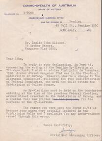
Document - AILEEN AND JOHN ELLISON COLLECTION: LETTER COMMONWEALTH ELECTORAL OFFICE
Letter dated 30th July, 1969 from the Commonwealth of Australia, State of Victoria, electoral office for the division of Bendigo, 45 bull Street, Bendigo addressed to Mr. Leslie John Ellison, 15 Archer Street, Kangaroo Flat, 3555. The letter advise Mister Ellison that due to changes in the federal electoral boundaries Archer Street is now in the Golden Square subdivision but because by-elections must be held on the boundaries of the previous federal election, Archer Street reverted to the subdivision of Marong.government, federal, electoral office -
 Ringwood and District Historical Society
Document - Folder, Land Sale, Parkhaven Estate, Heathmont, Victoria - 1968
Manilla folder containing 2-page foolscap size typewritten summary of Parkhaven Estate Heathmont multiple release allotment prices and two maps headed Plan of Subdivision - Part of Crown Portion 13, Parish of Ringwood. Subdivision includes Cuthbert Street, Waterloo Street, Sunset Drive, Markhill Place, Parkhaven Drive, Bayley Close and Blenheim Street. Agents - Consolidated Home Industries Limited, Lower Dandenong Road, Braeside, Vic., Phone 91-9791. Rep - Bruce Grant.Accompanying handwritten sales note researched in 2024 by Richard Carter - Carter Real Estate - "Generally $2500 to $4000 per lot". -
Lorne Historical Society
Map - Subdivision Map, J Batten Lithos, Plan of West Lorne Loutitt Bay Allotments IV and V
One of the early subdivision maps of Lorne.Black and white printed map on cream paper. The map shows allotments from the Erskine River to the Grand Pacific with an inset of allotments between Smith and Otway Streets. Allotments have the owners names.. The sea baths, Cobb and Co stables , Mountjoys Hotel, the Church of England, the telegraph line to Geelong and the jetty are also marked.lorne, subdivisions, -
 Ringwood and District Historical Society
Administrative record - Rate Books, Borough of Ringwood Valuation & Rate Cards for 1944-49 (Assessments 1460 - 1464), March 2012
Originally stored at Ringwood Council offices, then taken to PROV.Only source of ratepayers in the Borough of RingwoodDigital imagesPanaroma Cres, Ringwood. For Cirvydas, Berhard Groves, Hugh Keen, J Lloyd-Jones and Murial Scott (all Beals Subdivision). -
 Warrnambool and District Historical Society Inc.
Subdivision plan, Part of Preston Estate Parish of Wappan
This map possibly relates to land of John Bostock at Preston, Delatite. Part of a collection of papers relating to the Bostock family one of the earliest pioneering families in Warrnambool.Cream coloured map printed in black with sections coloured in pink. Plan of subdivision of part of crown allotments 15 and 17 and part of Preston pre- emptive right, Parish of Wappan, County of Delatite.warrnambool,bostock,augustus bostock map, delatite map,district of wappan map, -
 Ringwood and District Historical Society
Map, City of Ringwood - Rateable Properties Layout - c.1966
A0-size (approx) map of named streets, lot-numbered properties and locality features within City of Ringwood boundary. Coloured outlines of subsequent subdivisions. Seperate enlargement showing northern half of map.Scale: 8 chains to 1 inch. -
Bendigo Historical Society Inc.
Map - SUBDIVISION OF STERNBERG'S ESTATE, 24/06/1920
Map: Subdivision of Sternberg's Estate, Crown Allotments 75, 76, 76A, 76B and 77, Parish of Rochester West, County of Bendigo. Parish plan Canvas backed ( number 133 in Map Cupboard 1)map, bendigo, rural, sternberg's, crown allotments 75, 76, 76a, 76b, 77, rochester west, county of bendigo -
Whitehorse Historical Society Inc.
Legal record - Land Title, Creation of easement, 1929
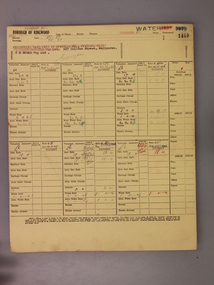
Ethel Mary Halley of Wellington Road Marylands S.A., registered proprietor of Lot 4 on Plan of Subdivision 4104 [Tyrrell Avenue Blackburn] to use for the purpose of drainage. Title Vol. 4824 Fol. 964713Ethel Mary Halley of Wellington Road Marylands S.A., registered proprietor of Lot 4 on Plan of Subdivision 4104 [Tyrrell Avenue Blackburn] to use for the purpose of drainage. Title Vol. 4824 Fol. 964713Ethel Mary Halley of Wellington Road Marylands S.A., registered proprietor of Lot 4 on Plan of Subdivision 4104 [Tyrrell Avenue Blackburn] to use for the purpose of drainage. Title Vol. 4824 Fol. 964713tyrrell avenue, blackburn -
Whitehorse Historical Society Inc.
Letter - Correspondence, Abattoir Property, 1937
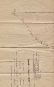
Letter between City of Box Hill and Shire of Blackburn and Mitcham re sale of Lot 2, Abattoir Estate. A plan of subdivision and list of allotments for auction by City of box Hill on 27 Oct 1937.Letter between City of Box Hill and Shire of Blackburn and Mitcham re sale of Lot 2, Abattoir Estate. A plan of subdivision and list of allotments for auction by City of box Hill on 27 Oct 1937.Letter between City of Box Hill and Shire of Blackburn and Mitcham re sale of Lot 2, Abattoir Estate. A plan of subdivision and list of allotments for auction by City of box Hill on 27 Oct 1937.land sales, city of box hill, shire of blackburn and mitcham, abattoirs paddock, aspinalls estate, woodhouse grove, box hill north, koonung creek, bishop, herbert thomas -
Whitehorse Historical Society Inc.
Article, Historic hostel bulldozed for development, 1994
Historical Leawarra Hostel on the former Winlaton site has been bulldozed for proposed residential subdivision in two lots.Historical Leawarra Hostel on the former Winlaton site has been bulldozed for proposed residential subdivision in two lots. The building was once the home of Joseph Tweedle[Tweddle] who financed the Tweedle Hospital in Footscray.Historical Leawarra Hostel on the former Winlaton site has been bulldozed for proposed residential subdivision in two lots. winlaton, leawarra hostel, tweddle, joseph -
 Kew Historical Society Inc
Photograph - Cosy Five Roomed Rough Cast Bungalow, Kew, J E Barnes, c.1920
Subdivision plans are historically important documents used as evidence of the growth of suburbs in Australia. They frequently provide information about when the land was sold on which a built structure was subsequently constructed as well as evidence relating to surveyors and real estate and financial agents. The numerous subdivision plans in the Kew Historical Society's collection represent working documents, ranging from the initial sketches made in planning a subdivision to printed plans on which auctioneers or agents listed the prices for which individual lots were sold. In a number of cases, the reverse of a subdivision plan in the collection includes a photograph of a house that was also for sale by the agent. These photographs provide significant heritage information relating house design and decoration, fencing and household gardens. The photograph is also aesthetically significant as it was taken by J. E. Barnes, a nationally significant photographer. He was the most important photographer to have worked in Kew. He was active as a photographer in the district from c.1906 until his death in 1921. Best known as 'the Embarkation Photographer' (see the Australian War Memorial collection), Josiah Earl Barnes was also the official photographer employed by the Borough (and later Town, then City) of Kew. He clearly also completed commercial jobs for local businesses, as is the case in this photograph of a house for a local real estate and financial agent. A modest weatherboard house with rough-cast rendered walls. The gabled entrance incorporates elements of the Japanese aesthetic. The strong lines of the dark timber gable are reinforced by the colour and shape of the pickets in the fence. In contrast to an earlier period, the chimneys appear truncated. The use of extensive double-hung sash windows in the front rooms reflects a new interest in light in houses. The use of separate sunshades over windows in an earlier period is here replaced by an extension of the roofline over the window. The photographer Josiah Barnes died in 1921; so, the photograph of the house must predate this date. The location of the house, which was advertised for sale, has to date not been identified. Illegible inscription. Photographer's information on mount.josiah earl barnes, j e barnes, photography - kew, interwar housing - victoria, 1920s housing - kew -
 Kew Historical Society Inc
Photograph - 2 Young Street, Kew, Paramount Photos, 1920s
Subdivision plans are historically important documents used as evidence of the growth of suburbs in Australia. They frequently provide information about when the land was sold on which a built structure was subsequently constructed as well as evidence relating to surveyors and real estate and financial agents. The numerous subdivision plans in the Kew Historical Society's collection represent working documents, ranging from the initial sketches made in planning a subdivision to printed plans on which auctioneers or agents listed the prices for which individual lots were sold. In a number of cases, the reverse of a subdivision plan in the collection includes a photograph of a house that was also for sale by the agent. These photographs provide significant heritage information relating house design and decoration, fencing and household gardens.A prepossessing, large home constructed in the Arts and Crafts style. Located on the banks of the Yarra at 2 Young Street, Kew overlooking the factories of Richmond, the design of the house takes account of the gradient with the addition of a level below the front entrance. The elegant roof includes a number of projecting gables and dormers. The gables are typically half-timbered and rendered. In addition to the asymmetrically placed portico, there are at least two open verandas, supported by timber pillars and with roofs that reflect the overall pitch of the roof of the housereal estate photographs, 2 young street - kew -
Port Melbourne Historical & Preservation Society
Plan - Sandridge, Department of Lands and Survey, "The Township of Sandridge", 5 Nov 1860
Map of Sandridge, lithographed 1860, showing subdivisions on Evans Street, but no other development West of the railway Lihographed at the Department of lands and Survey, Melbourne 5th November 1860. Hand drawn annotations added at unknown date.Hand written "clay ground" 18 chains long, 7.5 chains broad, 26 chains from railwayengineering - roads streets lanes and footpaths, sandridge lagoon, transport - railways, town planning, local government - borough of sandridge -
 Whitehorse Historical Society Inc.
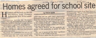
Article, Homes agreed for school site, 3/08/1994 12:00:00 AM
Subdivision of former Blackburn East Primary School Site,Article on development of 30 lot subdivision of former Blackburn East Primary School Site, Blackburn South. 1 - 41 Vicki Street. Developer Audcon Pty Ltd. In Nunawading Gazette 3 August 1994.Subdivision of former Blackburn East Primary School Site,blackburn east primary school, no. 4800, vicki street, blackburn south, bindy street, hudcon pty ltd, land subdivision -
 City of Kingston
Pamphlet - Colour, T. H. Ould Publishing Co, The Ridge Estate, Cheltenham, c. 1930
Sales plan for land in the suburb of Cheltenham, bounded by Johnston Street, Silver Street and Cavanagh Street, incorporating lots on either side of Sunray Avenue.The developing urban area of Cheltenham within the City of Kingston. This land sale pamphlet illustrates the subdivision of land within the municipality and the changing demographic of the district as new houses are constructed close to infrastructure.Colour pamphlet advertising for sale lots in The Ridge Entrance Estate, Cheltenham. Incorporates a map of the estate bordered by Johnston Street, Silver Street and Cavanagh Street, including subdivision lots on either side of Sunray Avenueland sales, estate, cheltenham -
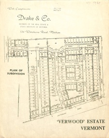 Whitehorse Historical Society Inc.
Document, Verwood Estate, Vermont
A subdivision plan of 'Verwood Estate', Vermontnon-fictionA subdivision plan of 'Verwood Estate', Vermontverwood estate vermont, drake real estate, drake co -
Glen Eira Historical Society
Document - Nithsdale
Photocopied copy of flyer for forthcoming subdivision of Caulfield Heights Estate on 27/10/1888. Includes locality plan and subdivisions. Photocopied copy of flyer for forthcoming sale of properties and mansion, Nithsdale on 18/09/1889, includes map of area.carriages and coaches, caulfield heights estate, caulfield north, maxwell grove, kambrook road, neerim road, blake street, bambra road, racecourse road, auctioneers, station street, glen eira road, paynes j., mansion, beauchamp brothers -
 Bendigo Historical Society Inc.
Document - H.A & S.R. WILKINSON COLLECTION: CONTRACT OF SALE
This business was owned by father and son, Henry Archibald Wilkinson and Samuel Ronald "Ron" Wilkinson. Henry (1882-1954) was born in Shepparton and died in Bendigo. He was married to Grace Hovendon in 1908. Samuel Ronald "Ron" (1914-1995), Henry's son, was married to Florence Jean McKerlie in 1937.Contract of sale of land dated 29th May, 1954 between Mrs. E.M. & Mr. H.A. Knight (sellers) and Mr. W.H. Randall (buyer) for land being lot 2 on plan of subdivision No. 19227 being parts of lots 27 and 28 on plan of subdivision No. 4134 being part of Crown allotment 97 and being the balance of the land comprised in certificate of titles volume 6441 folios 021 and 022 and situate Albion Street, Bendigo. Together with weatherboard dwelling and all sundry. Price 2,200 pounds.organization, business, h.a. & s.r wilkinson real estate -
Whitehorse Historical Society Inc.
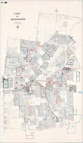
Map, Burwood Road, Box Hill City, 15/02/1952 12:00:00 AM
Detailed map of subdivision along the north side of Burwood Road, Box Hill between Station Street and Middleborough Road.Detailed map of subdivision along the north side of Burwood Road, Box Hill between Station Street and Middleborough Road. Shows many block owners, types of buildings, nature of fencing. Marked as 'Survey Plan No 5440'.Detailed map of subdivision along the north side of Burwood Road, Box Hill between Station Street and Middleborough Road. maps, burwood road, burwood, andrews street, greenwood street, tennyson street, middleborough road, station street