Showing 838 items
matching west family
-
 Kew Historical Society Inc
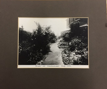
Photograph, Snow at Hallatrow, Aug 1899, 1899
An important early photograph of a significant Kew mansion - Hallatrow - dating from 1899.What appears to be a reprint of an earlier photograph of Hallatrow, now mounted, originally listed as A'Beckett Street West or Conran Street, but now 6 Holroyd Street in Studley Park. The photograph was originally taken when the house was occupied by the family of Thomas Brodribb. Pencil: “Snow at Hallatrow, Aug 1899” hallatrow - 6 holroyd street - kew )vic), historic buidlings - studley park - kew (vic) -
 Kew Historical Society Inc
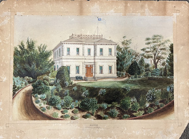
Work on paper, Madford: the property of A.S. King Esq
The Victorian-era mansion Madford in Wellington Street had several incarnations before it was finally demolished. While the precise details of its original construction have not been discovered, we know that it was originally named Elm Lodge, and that the property was offered for sale in 1863 by Thomas Mitchell, of the firm Mitchell & Bonneau, wholesale ironmongers and merchants. The house was sold in about 1873 to William Siddeley (1827-1905), who was described on the occasion of his death as ‘the father of Australian shipping’. The next owner was Arthur Septimus King (1827- 99), who renamed the house Madford after his purchase of the property in 1875. It was A.S. King for whom this artwork was completed. Following King’s death in 1899, portions of the property were sold, including to the Borough of Kew in 1905, to form the Alexandra Gardens. Then, in 1920, the house and its remaining lands were sold to the Catholic Church who opened St Anthony’s Home for Children on the site in 1922. That building was promptly demolished, and the site redeveloped circa 1976.Gift of James Pearson, 2022This fine perspective drawing of the architectural elements of Madford [formerly Elm Lodge, later St Anthony's Home for Babies] is contrasted with the freer addition in watercolour of the layout and plants of the garden facing Wellington Street. The view selected is the south-facing main facade and the west facing side. After A.S. King purchased the house in 1875, it was extended with new wings at the rear to accommodate his large family. There is no indication of these extensions in the painting so its creation must predate the renovations, and probably depicts the original building on the site."MADFORD / The Property of A. S. KING Esq"elm lodge, madford, st anthony's home for babies, houses -- wellington street -- kew (vic.), thomas mitchell, william siddeley, arthur septimus king -
 Kew Historical Society Inc
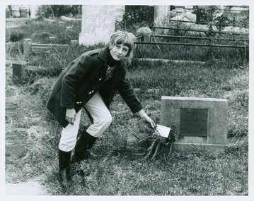
Photograph - Tour of the Boroondara (Kew) General Cemetery, 1977
Boroondara Cemetery, established in 1858, is within an unusual triangular reserve bounded by High Street, Park Hill Road and Victoria Park, Kew. By the 1890s, the Boroondara Cemetery was a popular destination for visitors and locals admiring the beauty of the grounds and the splendid monuments. The Boroondara Cemetery is of historical significance for the graves, monuments and epitaphs of a number of individuals whose activities have played a major part in Australia's history. They include the Henty family, artists Louis Buvelot and Charles Nuttall, businessmen John Halfey and publisher David Syme, artist and diarist Georgiana McCrae, actress Nellie Stewart and architect and designer of the Boroondara and Melbourne General Cemeteries, Albert Purchas.Walking tour led by Kew Historical Society members for members of the Royal Historical Society of Victoria in 1977. The photograph shows a Kew youth placing a sprig of Rosemary on Ellen Quick's grave. The photograph was one of six taken by KHS member Stewart West on that occasion, and subsequently donated by him to the collection by him.Reverse: "Kew youth placing a sprig of rosemary on grave of Ellen Quick nee Derrick who was the first burial on 12/3/1859. Her family Derricks were early Kew Landowners." boroondara general cemetery, kew cemetery, walking tours, ellen quick, dannock family, kew pioneers -
 Kew Historical Society Inc
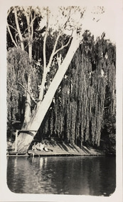
Photograph - Macauley's, Kew, 1924
Henry Beater Christian (1886-1962) , was a descendant of one of the earliest settler families in Kew. Employed at the Kew Asylum as a 'public servant', he was a skilled amateur photographer, photographing numerous scenes in Kew and on his travels around Victoria. The majority of his photographs date from 1916 to 1929. His finest photographs are housed in two photograph albums. A fine, early view of the river bank at Macauley's boat sheds on the Yarra River at Kew.Digital copy of a photograph from page 2 of the 47-page photograph album containing 261 gelatinous silver images, loaned by Diane Washfold with permission given to digitise and hold a copy in our collection. The photograph is of the river bank at Macauley's boat sheds on the Yarra River at Kew. The boat sheds were located at the west end of Molesworth Street. The photograph is taken from the Yarra Bend Park side of the river, or from a boat on the river. A group, probably members of the photographer's family, are sitting underneath a giant weeping willow."Macauley’s Kew"henry beater christian (1886-1962), landscape photography, kew (vic.) — yarra river, christian-washfold collection, photograph albums, macauley's boat sheds -
 Kew Historical Society Inc
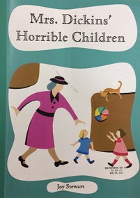
Book, Mrs Dickins' Horrible Children: Anecdotes in the Life of a Growing Family, 2004
Mrs Dickins' Horible Children: Anecdotes in the Life of a Growing Family / by Joy Stewart. Whitfield, 2004. Qld. : Marie-Claire Nemel, 2004. 91 p. : col. ill., ports. ; 29 cm. non-fictionjoy stewart, dickins family -- kew (vic.) -
 Kew Historical Society Inc
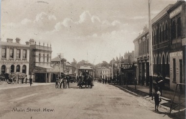
Postcard, Main Street, Kew, c.1890
The Kew Historical Society's Pictures Collection is comprised of photographs, postcards and original works of art. The postcards include original (mainly) images dating from the 1900s to the present. A number of postcards, some of which have numerous variants, were published as parts of series. Others are original images customised as postcards. Many of the postcards in the collection depict places within the suburbs of Kew and Kew East. Others depict locations in Victoria or internationally. A monochrome postcard showing Main Street [High Street], Kew, looking south west from near its junction with Cotham Road, showing: Ryan’s Council Family Hotel, T. G. Jellis (baker, confectioner), Herbert King (undertaker), L. Merritt (boot warehouse), horse tram, horse drawn vehicles and pedestrians.Post card text addressed to Miss Newell of Balmain.high street - kew, cotham road - kew, tramways - kew -
 Kew Historical Society Inc
Memorabilia - Lock of hair of Thomas Henty (1775-1839) in a hollowed Cartwheel Penny
... of national significance for its strong connection to the Henty family ...This King George III 1797 penny, colloquially described as a ‘Cartwheel’ because of its large size and thick rim, was manufactured in Great Britain from 1797-99. The penny and the twopence were the first coins shipped to New South Wales by the British Government. In 1800, Governor King issued a proclamation that forbade their export. This coin is one of the 132,000 coins sent to Australia in 1800. It is not uncommon to find cartwheel pennies used as containers. They were reputedly used to conceal a more valuable coin or for smuggling. The penny was purchased by the Society as part of a small collection of Henty memorabilia and portraits from the owner of Moorabool Antiques, Geelong in 2021, which had in turn acquired the item from the estate of Dennis Alston of Alston's Antiques in Hamilton, Victoria.This cartwheel penny, used to contain a lock of hair of Thomas Henty (1775-1838), is of statewide significance to Tasmania, where he settled and died, and to Victoria, where his children and their descendants were notable pioneers, squatters and subsequently landowners in the Western District. The item is also of national significance for its strong connection to the Henty family, notable British settlers of southeastern and southwestern Australia in the 1830s. The connection to Kew (Vic.) is that members of the Henty family owned important mansions in Kew in the 19th century. Thomas Henty was the father of Stephen George Henty of 'Findon', and Francis Henty of 'Merino Downs' in the Western District and 'Field Place', Kew. Numerous members of the Henty family are buried in the Boroondara General Cemetery.Object of personal memorabilia. Coiled and bound lock of hair of Thomas Henty contained in a hollowed-out copper 'cartwheel' penny.OBVERSE: Georgius III . D : G . REX / REVERSE: Britannia 1797 / SELLER'S LABEL: Lock of hair from the late Thomas Henty, born 1775thomas henty, henty family, launceston, west tarring -- sussex (uk), tasmanian pioneers, australia - early settlers, cartwheel pennies -
 Kew Historical Society Inc
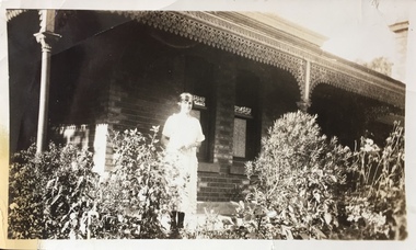
Photograph - Marion Isabel Dudley
"Hedge Hopping" over Kew. About mid day on the 23rd of July, 1924 an A.R.27 (Avro 504 K) plane piloted by Arthur Affleck "buzzed" the house at 91 Wellington Street, Kew, so low that the pilot was easily recognised from the ground and returned our eager waves, he then flew north to "buz" his mother at 27 Kent Street, Kew, which is situated near the west gates of the Boroondara Cemetery and after several circuits around noticed that a horse drawn funeral had been disturbed while entering the Cemetery - the horses taking fright. On observing this the pilot then returned to Point Cook where he reported 'engine trouble' over Kew. Small black and white photographic positive showing Marion Isabel Dudley standing on the porch of her house which is believed to be at 91 Wellington Street, Kew. The photograph is attached to summary text and contemporary press reportsReverse: "KH-167 / Marion Isabel Dudley the girl Arthur "hedge hopped" to see in Kew 24th July 1924"dudley family, marion isabel dudley, arthur affleck, boroondara general cemetery -
 Kew Historical Society Inc
Book, Jules Feldmann, Gadsden, the first 100 years, 1980
... of the Gadsden family West Melbourne : J. Gadsden Australia, 1980 iii ...Biography of the Gadsden familyWest Melbourne : J. Gadsden Australia, 1980 iii, 169 p. : ill. (some col.) ; 23 cm. non-fictionBiography of the Gadsden familygadsden family, j gadsden australia -- history, packaging industries -- australia -- j gadsden australia 1879-1979, package goods industry -- australia, australia -- social life and customs -
 Sunbury Family History and Heritage Society Inc.
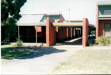
Photograph, Glengala Park Primary School, 3rd March 1993
The building is the Glendale Park Primary School situated in Sunshine West and opened in 1976. The multicultural school with 150+ students from thirty different cultural backgrounds runs a very inclusive program. The students from Bulla Primary School visited on the 3rd March 1993 and enjoyed the day learning about the school and participating in a number of activities with the students. The visit to a school located in one of Melbourne's western suburbs was a contrast to the semi-rural primary school for the students from Bulla Primary School in the 1990s.A non-digital coloured photograph of a red-brick school building.glendale park primary school, bulla primary schooil, school excursions -
 Sunbury Family History and Heritage Society Inc.
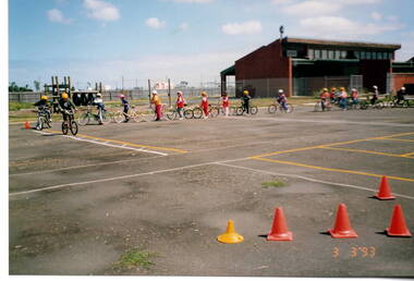
Photograph, Glengala Park Primary School, 3rd. March 1993
The students from Bulla Primary School visited Glengala Park Primary School in Sunshine West in 1993 and participated in a number of activities from the Glendale children. Bicycle education was one of the activities that they enjoyed on the day.A non-digital coloured photograph of children partaking in a lesson on bike riding on a large asphalted open space. A sports pavilion is in the background.school excursions, glendale park primary school, bicycle education -
 Sunbury Family History and Heritage Society Inc.
Photograph, Wheat silo
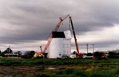
The wheat silo was erected on railway land on the west side of the railway line at Sunbury from approx 1970s - 1980s. It served as a grain storage provision for the local cereal farmers.The former CFA depot which was in Evans Street. With the expansion of the shopping centre the silo was dismantled to provide commercial development on the west side of the railway line.The wheat silo is a reminder of past agricultural industries that were carried out in Sunbury.A non-digital photograph of two trucks and a crane dismantling a metal wheat silo, which has been standing in an open area. A CFA pavilion is visible in the distance.wheat storage, silos, sunbury railway station, evans street -
 Sunbury Family History and Heritage Society Inc.
Photograph, Ball Court Hotel
The hotel was built some time shortly after 1842 by John Cahill, who arrived in the colony in 1842 from Thurles in Tipperary, Ireland. The building although much altered with render covering the original \blue stone structure is on the south-west corner of Macedon and Jackson Streets. The hotel was called the Ball Court because Cahill also had a hand-ball court set up behind the hotel.Originally five hotels were built along Macedon Street between Jackson Creek and Evans Street. The Ball Court Hotel is the only one still standing and operating as a hotel.A non-digital black and white photograph with a cream border of man and three ladies standing outside a single story blue stone hotel building with a corner entrance. AS well as the corner entrance there is another doorway on the RHS along with three narrow windows and three other windows on the other side. One of the ladies is holding a little child. Two trees surrounded by tree guards are on each side of the photograph.Ball Court Hotel, John Cahillball court hotel, hotels, sunbury, macedon street, jackson street, ball court -
 Sunbury Family History and Heritage Society Inc.
Photograph, Bulla P, 1988
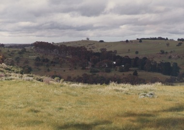
The photograph was taken from the west side of Bulla Hill near Loemans Road, which is west of the township of Bulla. The rocks outlining the name of the town were a landmark when approaching the township along the Sunbury Road on the west side of the town. They remained there until the school was closed in 1996 and the new owner removed them.A coloured photograph of Bulla Primary School with the word 'Bulla' formed from rocks on the distant hillside. schools, bulla primary school -
 Sunbury Family History and Heritage Society Inc.
Photograph, Bulla Bridge
A coloured photograph of the bluestone bridge which spans Deep Creek at Bulla. The photograph is taken facing upstream. The bridge was constructed in 1869 and replaced a ford crossing further downstream. Many bridges in the South West of Victoria were constructed from Bluestone basalt rock because the area is on a large volcanic plain and that rock is in abundance. A coloured photograph of the Bulla Bridge which spans the Deep Creek at Bulla. Photograph 0178 is an identical photograph tho this one.bridges, bulla bridge -
 Sunbury Family History and Heritage Society Inc.
Photograph
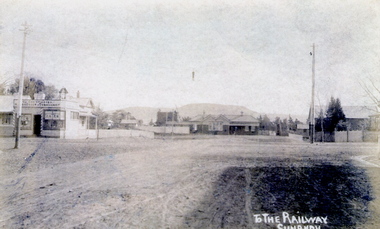
The post card is an early view of the intersection of Brook and Evans Street looking west and towards Sunbury Station. Mount Holden is in the distance. Chris Christianson's shop is on the LHS of the picture with the post office on the RHS. This image is an early view of Sunbury town centre with the railway station and post office. Like many country towns of this era, The roads have been formed but not surfaced. A sepia photograph in post card format of a view of a town centre showing an intersection and some small buildings with a hill in the distance.TO THE RAILWAY/SUNBURYbrook street, evans street, sunbury railway station, christianson, chris. -
 Sunbury Family History and Heritage Society Inc.
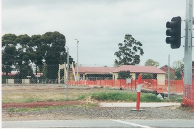
Photograph, c1999
The open are in the foreground was part of railway land on the west side of Sunbury Station along Horne Street. The initial preparations to develop the area into a commercial and entertainment precinct were just commencing. The development that took place on this site was indicative of the growth that was taking place in Sunbury in the early 2000sA coloured photograph of an open area feed off with temporary netting in preparation for construction work. A set of traffic lights are on the RHS of the photograph and a station is in the middle distance.sunbury railway station -
 Sunbury Family History and Heritage Society Inc.
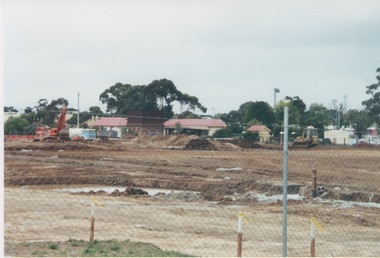
Photograph, 2000
Excavation work to remove the grasslands and trees on the railway land on the west side of the Sunbury Station to make way for commercial development on that side of the line.A coloured photograph of excavation work in operation on land which has cyclone fencing around its perimeter. There are buildings in the middle distance beyond the work site.sunbury railway station -
 Sunbury Family History and Heritage Society Inc.
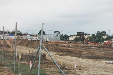
Photograph, 13 April 2000
In 2000 work commenced on the further development of railway land on the west side of Sunbury station for the construction of commercial and entertainment facilities. Prior to this time the land had been undeveloped and was often used to accommodate visiting circus troupes. Cereal storage silos also occupied this area for some time. The development of this area has been a reflection of the rapid expansion of settlement within Sunbury and surrounding areas that occurred during the early years of the twentieth century.A coloured photograph of a fenced off area undergoing development with earthmoving equipment and trucks in operation and some commercial buildings visible in the middle distance.sunbury railway station -
 Sunbury Family History and Heritage Society Inc.
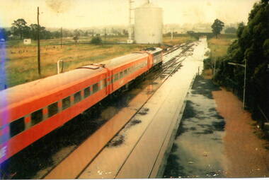
Photograph, 17 December 1985
On 17th December 1985 record torrential rain fell in Sunbury, which flooded the main Melbourne Bendigo rail line and disrupted traffic. The photograph is looking to the north of the station and takes in the historic Macedon Street bridge and the open ground with the storage silo on the west side of the railway line. A coloured photograph of a former V Line train stopped at a station where the railway line has been flooded. A storage silo occupies vac ant ground adjacent to the railway line.sunbury railway station, storage silos, horne street -
 Sunbury Family History and Heritage Society Inc.
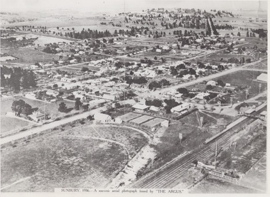
Photograph, 1936
The aerial view of Sunbury was featured in The Argus newspaper in 1936 in recognition of 100 years of European settlement of the area. It shows the extent of the township in 1936 which extended from the railway line in the west to the Jackson Creek in the east and the Sunbury Asylum in the south and northwards towards Macedon Street. The photograph was taken when Sunbury was a country settlement 25 miles ( 37 kms) from Melbourne. Since the 1980s the area grown rapidly and is now an outer suburb of Melbourne.A black and white aerial photograph with a cream border of the Sunbury township. SUNBURY 1936 - A SOUVENIR AERIAL PHOTOGRAPH ISSUED BY THE ARGUS.aerial photographs -
 Surrey Hills Historical Society Collection
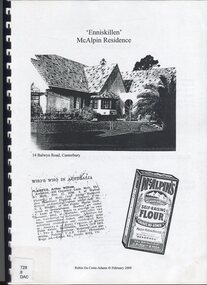
Book, Robin Da Costa-Adams, Enniskillen McAlpin Residence, Feb-09
This report was prepared by historian Robin da Costa-Adams to assess the cultural heritage significance of "Enniskillen" at 14 Balwyn Road, Canterbury. It includes some family history on a number of prominent families - the McAlpin family, the Hindson family and the architect, Arthur William Plaisted who designed 'Enniskillen' for the McAlpin family. McAlpin's was a major Victorian flour company in the nineteenth and early twentieth centuries. Owned and operated by J. McAlpin and Sons, the company sold its flour products across Australia and overseas. McAlpin's developed a successful marketing campaign which was pitched directly at housewives. One innovation was the publishing of a free cookbook which had recipes in it that used McAlpin's products. These free cookbooks were published successively from the 1930s through to the 1960s in Australia. Arthur Plaisted also designed the Surrey Hills Medical Centre in Union Road c1911. Some of his work is featured on the State Library of Victoria Collection. Robin da Costa-Adams has researched and written many publications including 'Blackburn a picturesque history, 1978'; 'Land of Gold: Gwlad yr Aur: James Tipping and a Mining Heritage'; 'Address (with signatories) from the women of Ballarat & Ballarat East to the women of England 1864 : against transportation of convicts', compiled and indexed by Robin; and 'Connie's Story : commemorating the Life of Mrs Edward (Plorn) Dickens'. Robin has been a tireless campaigner for heritage protection in Canterbury. This document on 'Enniskillen' was included with Robin's submission for 2 VCAT hearings regarding possible development of the property. Both resulted in a judgement against the proposed developments. In the recent (2021) hearing the document was specifically mentioned in the judgement.A report prepared by Robin da Costa-Adams in 2009 to assess the cultural heritage significance of "Enniskillen" at 14 Balwyn Road, Canterbury. It includes some family history on the McAlpin family, the Hindson family and the architect Arthur WIlliam Plaisted family.(mr) arthur plaisted, (mr) walter plaisted, enniskillen, shrublands, house names, (mr) francis henty, (mrs) mary henty, (mr) ernest carter, heathfield, (mr) john hindson, (mrs) alice hindson, (mr) william hindson, (mrs) annie west mcalpin, (mr) john mcalpin, mcalpin bakery, (mr) keith matthies, dental surgeon, (mr) william wolf, architects, (miss) mary beacon, robin ca costa-adams -
 Surrey Hills Historical Society Collection
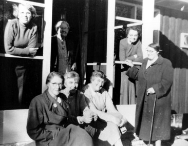
Photograph, Drs Agnes and Roberta Donaldson and friends
Agnes (b 1894, Linton; died 1977, Box Hill) had been a masseur before entering medical school at Melbourne University. She transferred to Edinburgh and graduated from there. She joined her sister Amelia Roberta, known as Roberta, at ‘Luxmee’, 4 Windsor Crescent. She was born in 1891 and died at Surrey Hills on 1 May 1972. She had a long illness before her death. Agnes is seated left foreground; Roberta is standing at the right. Their father James Blair Donaldson had been a doctor at Linton, near Skipton and a brother, James Blair Donaldson Jnr (1888-1971) was a doctor in Skipton. A second brother Alexander Somerville Donaldson (1887-1963) also lived in Surrey Hills. He had a number of addresses and occupations including: 1927 - 44 Albany Crescent (Chauffeur); 1949 - 5 Beatrice Avenue (mechanic) and 1963 - 28 Albert Crescent (gardener). Their mother was Amelia Jane Emerson. Transcription of grave in Section C, Baptist in Melbourne General Cemetery gives further family details: “In affectionate remembrance of Jane Duff the beloved wife of Robt. DONALDSON who died at Carlton, Victoria, 8 Aug 1889, age 56 years and of their children David Russell and Mary McIntosh who died in infancy. Until the Easter glory lights the skies; until the dead in Jesus shall arise and He shall come, but not in lowly guise Good night. East also Agnes SHEPHERD mother of Jane D. DONALDSON born at Dundee Scotland 30 Apr 1800, died at Carlton 8 Apr 1891. West also Robt. DONALDSTON teacher died 13 Jul 1910, age 80 years Emily Mary DONALDSON died 24 Jan 1923, age 64 years Alexander Somerville DONALDSON beloved husband of Mary died 26 Oct 1963 Dr. James Blair DONALDSON of Linton, Scotland born 11 Mar 1859, died 7 Sep 1944 also Amelia Jane beloved wife of the above born 11 Nov 1859, died 13 Jul 1946 beloved parents of Somerville, Blair, Roberta and Agnes.” A black and white photograph of seven ladies on the porch of a building.miss agnes donaldson, miss roberta donaldson, dr roberta donaldson, dr agnes donaldson, miss amelia roberta donaldson, dr amelia roberta donaldson -
 Surrey Hills Historical Society Collection
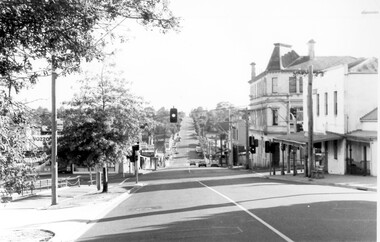
Photograph, Union Road, Surrey Hills in 1982 (1), 1982
Taken in January 1982; very similar to SHP0635. Surrey Family Hotel (McNeill's Family Hotel) was built in 1888 by Alexander McNeill. It closed as a hotel after the Local Option vote in 1920. Vic Dartnell joined his cousin Percy Cathcart in a pharmacy on the opposite corner in 1936 and moved it to this corner in 1940. His son John followed as the pharmacist and then his daughter Amanda. After the Dartnell family sold the business, the pharmacy continued in a similar manner as a compounding pharmacy and retained 'Dartnell' in its name. Black and white photo of Union Road at the intersection of Canterbury Road. On the left the edge of the Surrey Gardens can be seen and on the right the Dartnell's Pharmacy building on the SE corner and McNeill's Family Hotel building (pre-renovation) on the NE corner. Distinguishable advertising signs include V A Dartnell, Vozzo's Supa Valu Licenced Supermarket on the NW corner and the ANZ Bank on the west side of Union Road beyond the intersection.businesses, shops, union road shops, dartnell's pharmacy, mcneill's family hotel, surrey family hotel, vozzo's licenced supa valu supermarket, anz bank, surrey gardens, vic dartnell, john dartnell, amanda dartnell -
 Surrey Hills Historical Society Collection
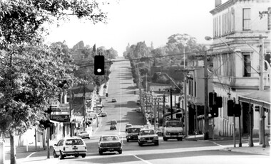
Photograph, Union Road, Surrey Hills in 1982 (3), 1982
Taken in January 1982; very similar to SHP0628 & SHP0635. Surrey Family Hotel (McNeill's Family Hotel) was built in 1888 by Alexander McNeill. It closed as a hotel after the Local Option vote in 1920. The Surrey Squash Courts were built in what had been the Surrey Theatre. The facade of the ANZ Bank building documents the past history of the building having earlier been the ES&A Bank. Black and white photo of Union Road at the intersection of Canterbury Road. On the right the edge of Dartnell's Pharmacy building on the SE corner can be seen and McNeill's Family Hotel building (pre-renovation) on the NE corner. Distinguishable advertising signs include the ANZ Bank and Dalkeith Office Supplies on the west side of Union Road beyond the intersection; also the Surrey Squash Courts.businesses, shops, union road shops, dartnell's pharmacy, mcneill's family hotel, surrey family hotel, anz bank, surrey gardens, dalkieth office supplies, surrey squash courts -
 Surrey Hills Historical Society Collection
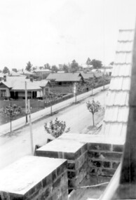
Photograph, Union Road looking west from the steeple of Holy Trinity Church, 1922, 1922
At the edge of the church roof and on the horizon is 'The Knoll' on the corner of Union Road and Wandsworth Road. To the left of this is 297 Mont Albert Road, home of the Michael Parer family and further left is "Quamby", home of the Sherar family. This is easily recognised by the square viewing tower located on the west wing of the house. The Sherar family owned 'Quamby' from 1900 until 1925, when it became Mosgiel Private Hospital. Norman Carter took many photos of Surrey Hills and Mont Albert in the 1920s; many associated with events and activities of the Church of England. Black and white photo of taken from the steeple of Holy Trinity Church, during its construction, across Union Road to the north-west. In the foreground immature street trees can be seen and an original telephone pole with white insulators. The street has formed paths and bluestone kerb and channelling. holy trinity anglican church, union road, the knoll, quamby, street trees, telegraph and light poles, mosgiel hospital -
 Brighton Historical Society
Clothing - Riding habit, 1910s-20s
This item is from the "Barone" Collection. "Barone" (also known as "Seaview") was a stately Brighton home built at 9 Moule Avenue prior to 1855 and demolished in 1986. The house's residents included Edward Elgin Browne (during 1859-72), a Melbourne tea merchant, and the family and descendants of retired Scottish Army captain Archibald Black (during the period 1880-1970). Its neighbors included “St Ninians” owned by the Ward- Cole family, “Seacombe” owned by the Moule family, and the home of James Grahame and his family. The items in the "Barone" collection were largely donated by two of the house's later owners, Mrs Doris Halkyard and Mrs Brian Brandt.An English-made “Busvine” black wool herringbone twill riding habit comprising jacket and safety skirt, (jodhpurs missing) from late 1800’s to early 1900’s. The jacket (.1) features a black short pile silk velvet inset notched lapel collar secured with a single button at the apex of the waist and a single button near the collar for use in inclement weather. The sleeves join the bodice high on the shoulder with a full cut head to the sleeve and a tapered curved shape to the hand. The sleeve secures at the wrist with four black buttons. From the waist the jacket flares over the hip through princess line shaping and finishes with a curved front on either side. The seams of the shaping panels intersect single functional flapped besom pockets on either front panel. The back of the jacket features a centre back seam and two princess-line shaping seams that finish in a double vent on either side of the centre back. The jacket length would have finished approximately just below the bottom of the wearer. The apron fronted safety skirt (.2) secures from the waist at the front of the left thigh with five buttons. Over the wearers, right leg the skirt shapes to accommodate the rider’s right knee whilst sitting sidesaddle with her legs on the horses left flank. The base of the skirt has an elastic strap, which hooks around the rider’s leg to reduce the danger of the rider’s skirt become tangled, should the rider become un-seated. When the riders is not mounted the skirt can be secured with a button around the body to provide additional modesty as well as assist walking without the skirt dragging on the ground.Jacket: Manufacturer's label “Busvine, By serial appointment to Her Majesty The Queen, 4 Brook Street W.” Owner label “Doreen Wright” this label appears far more modern than the manufacturers label. Skirt: Manufacture's label: “J. Busvine and Co, 4 Brook Street, London W." In handwriting “Miss Wingfield” Manufacturers label: Busvines Patent Safety Skirt, protected by two separate patents. 4 Brooks St London West.barone, riding habit, j. busvine and co, seaview, brighton -
 National Wool Museum
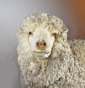
Taxidermy Sheep, Mr. Polwarth, c1980
The Polwarth is the first new breed of sheep developed in Australia for Australian conditions. 75% Merino and 25% Lincoln, the fleece is white, soft and high yielding, and is resistant to fleece rot. A dual purpose breed, the Polwarth produces fine wool as well as a quality carcass that is particularly lean and well suited to lamb and mutton. A large breed of sheep, mature ewes generally reach 50 to 60kg, while the mature rams, like Mr Polwarth, typically weigh in at 66 to 80kg. This breed has approximately 7kg of fleece per animal which is 23 to 25 microns. The Polwarth was bred to the west of Geelong at Tarndwarncoort Station, just outside of Colac, in the state electorate of Polwarth. Settled by the Dennis family in 1840, the station is still owned by the same family and they still breed Polwarth sheep.Polwarth ram sheep. Has a medium size body and short legs with white fleece covering his eyes. sheep, polwarth -
 Port Fairy Historical Society Museum and Archives
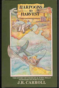
Book, Warrnambool Institute Press, Harpoons to harvest : the story of Charles and John Mills, pioneers of Port Fairy / J.R. Carroll, 1989
The story of Charles and John Mills, pioneers of Port Fairy. Includes genealogical information.xv, 286 p., [12] p. of plates : ill., geneal. tables, maps, ports. Includes index. Geneal. tables on lining papers. Bibliography: p. 225-260non-fictionThe story of Charles and John Mills, pioneers of Port Fairy. Includes genealogical information. maritime, mills, john brabyn, 1810-1877, charles frederick, 1812-1855, mills family, pioneers -- victoria -- port fairy -- biography, pioneers -- tasmania -- biography, australian history, biography, exploration, genealogy, harbour master, mills : charles and john, mills brothers, port fairy, shipping, warrnambool history, whaling, wrecks, book -
 Port Fairy Historical Society Museum and Archives
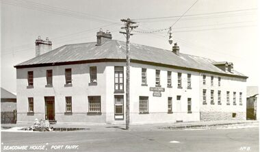
Postcard - Photograph, Seacombe House Port Fairy
Seacombe House Formerly named The Stag Cnr Sackville and Cox Streets Port Fairy John Sanders (Saunders) first came to Port Fairy in charge of the "Sally Ann" owned by the Henty family of Portland. He left the sea behind in 1844 and established the "Sally Ann Inn" named for his old ship, on the site of the present day Star of the West hotel. After selling the Sally Ann Inn to John Taylor he acquired the land on the South west corner of Sackville Street and erected a detached cottage facing Sackville Street for which he obtained a licence to sell alcohol and named the premises The Stag Inn. He died in 1850 and his wife leased the Inn to John Mason. By 1852 a large two story rendered bluestone building had been constructed on the corner site. The second un rendered section was probably added in 1854. Abijah John Brown became licencee in 1855 and made the Stag the centre of entertainment for the district, with many balls, dinners and concerts taking place there. It boasted "a billiard room and a twenty stall stables and coach house". By 1861 Abijah Brown had left The Stag and Lennox Trew was now owner and licencee. It came up for sale in 1869 but failed to sell. After Trew's death in 1886 it was sold to a syndicate and opened as a boarding school. It later became a Coffee Palace and Accomodation house named Seacombe House, and in the 1950's a motel was built on the old stable site. It is still a Hotel Motel and a restaurant which has revived the old name of "The Stag". Black and white Photograph of 2 story rendered building with multi paned windows and power pole on cornerhotel, lennox trew, abijah brown, john sanders, john saunders, john mason., sackville street, cox street, stag inn, stag hotel, seacombe house, coffee palace