Showing 22288 items
matching parks
-
 Ballarat Tramway Museum
Album, Brian Andrews, UR1 - 300 Photo - Bendigo, Ballarat trams, 1968
Album compiled by the photographer containing generally 89 x 124mm of: • Bendigo – 151 black and white prints • Ballarat – 119 black and white prints and some colour • Melbourne – 20 colour and black and white prints - featuring Queensway, the Hump, Royal Park, route 82, Dandenong Road, Glenferrie Road, Barkers Road and Hawthorn Bridge. • Rome, Hong Kong and Toronto – 14 prints See items 8638 to 8642 for negatives of the Ballarat and Bendigo photos and related image files held on the BTM Demonstrates the work of the photographer.Album - heavy plastic covered covers, with 100 sewn and glued paper sheets each side with three plastic sleeves for photographs with a negative pocket page at the rear. See list of btm8637 - Ballarat list.doc for a location listing of the Ballarat photographs.trams, tramways, ballarat, bendigo, melbourne, hong kong, toronto, rome, brian andrews -
 Kew Historical Society Inc
Plan - Subdivision Plan, Riversdale Estate, 1939
The Kew Historical Society collection includes almost 100 subdivision plans pertaining to suburbs of the City of Melbourne. Most of these are of Kew, Kew East or Studley Park, although a smaller number are plans of Camberwell, Deepdene, Balwyn and Hawthorn. It is believed that the majority of the plans were gifted to the Society by persons connected with the real estate firm - J. R. Mathers and McMillan, 136 Cotham Road, Kew. The Plans in the collection are rarely in pristine form, being working plans on which the agent would write notes and record lots sold and the prices of these. The subdivision plans are historically significant examples of the growth of urban Melbourne from the beginning of the 20th Century up until the 1980s. A number of the plans are double-sided and often include a photograph on the reverse. A number of the latter are by noted photographers such as J.E. Barnes.The Riversdale Estate in Hawthorn created a subdivision of 20 allotments bordering on Riversdale Road and Riversdale Court (which was created by the subdivision). The Locality Plan at right lists the major public buildings in the area: Burnely Horticultural Gardens, Hawthorn Tram Depot and Railway Station, Scotch College and the River Yarra and The Boulevard.subdivision plans - hawthorn, riversdale estate -
 Kew Historical Society Inc
Plan - Subdivision Plan, Corsewall Estate, Hawthorn, 1938
The Kew Historical Society collection includes almost 100 subdivision plans pertaining to suburbs of the City of Melbourne. Most of these are of Kew, Kew East or Studley Park, although a smaller number are plans of Camberwell, Deepdene, Balwyn and Hawthorn. It is believed that the majority of the plans were gifted to the Society by persons connected with the real estate firm - J. R. Mathers and McMillan, 136 Cotham Road, Kew. The Plans in the collection are rarely in pristine form, being working plans on which the agent would write notes and record lots sold and the prices of these. The subdivision plans are historically significant examples of the growth of urban Melbourne from the beginning of the 20th Century up until the 1980s. A number of the plans are double-sided and often include a photograph on the reverse. A number of the latter are by noted photographers such as J.E. Barnes.This is a second, more complete version of the Corsewall Estate subdivision that is held by the Society. The Coreswall Estate was a subdivision, bordering on Barkers Road and Auburn Road, which created Corsewall Close. This relatively late subdivision included 29 allotments. The subdivision plan includes the dimensions of each lot as well as the width of the existing and projected roads and turning circles. The Corsewall Close Precinct is now listed on the Victorian Heritage Database (HO147) and is noted for its ‘consistent flat-type development over the entire street, which has been cleverly designed to make multi-unit dwellings appear as single buildings’. In this second version of the plan, the rarity of this late subdivision is emphasised by the auctioneers. The original plan must have contained a photograph, which is unfortunately truncated here.subdivision plans - hawthorn, corsewall estate -
 Kew Historical Society Inc
Plan - Subdivision Plan, Jaques Estate, 1927
The Kew Historical Society collection includes almost 100 subdivision plans pertaining to suburbs of the City of Melbourne. Most of these are of Kew, Kew East or Studley Park, although a smaller number are plans of Camberwell, Deepdene, Balwyn and Hawthorn. It is believed that the majority of the plans were gifted to the Society by persons connected with the real estate firm - J. R. Mathers and McMillan, 136 Cotham Road, Kew. The Plans in the collection are rarely in pristine form, being working plans on which the agent would write notes and record lots sold and the prices of these. The subdivision plans are historically significant examples of the growth of urban Melbourne from the beginning of the 20th Century up until the 1980s. A number of the plans are double-sided and often include a photograph on the reverse. A number of the latter are by noted photographers such as J.E. Barnes.The Jaques Estate was a small subdivision of eight residential allotments bordering Jaques Street and Barkers Road in what is now Hawthorn East. Advertised in The Argus as being in ‘Upper Hawthorn’ the subdivision was claimed to include: ‘charming villa sites in excellent situations, with every convenience available, and with superior homes surrounding’.subdivision plans - hawthorn, jaques estate -
 Kew Historical Society Inc
Plan - Subdivision Plan, Houghton Street & Buchanan Avenue, Balwyn North, ca. 1906
The Kew Historical Society collection includes almost 100 subdivision plans pertaining to suburbs of the City of Melbourne. Most of these are of Kew, Kew East or Studley Park, although a smaller number are plans of Camberwell, Deepdene, Balwyn and Hawthorn. It is believed that the majority of the plans were gifted to the Society by persons connected with the real estate firm - J. R. Mathers and McMillan, 136 Cotham Road, Kew. The Plans in the collection are rarely in pristine form, being working plans on which the agent would write notes and record lots sold and the prices of these. The subdivision plans are historically significant examples of the growth of urban Melbourne from the beginning of the 20th Century up until the 1980s. A number of the plans are double-sided and often include a photograph on the reverse. A number of the latter are by noted photographers such as J.E. Barnes.A hand-drawn subdivision plan listing six blocks bounded by Houghton Street, Doncaster Road, Buchanan Avenue and Maud Street, North Balwyn. Written on the plan of subdivision are the lot numbers, the dimensions of the blocks and the price at which two lots were for sale or had been sold for.subdivision plans - balwyn -
 Kew Historical Society Inc
Plan - Subdivision Plan, Doona Estate, Toorak, 1929
The Kew Historical Society collection includes almost 100 subdivision plans pertaining to suburbs of the City of Melbourne. Most of these are of Kew, Kew East or Studley Park, although a smaller number are plans of Camberwell, Deepdene, Balwyn and Hawthorn. It is believed that the majority of the plans were gifted to the Society by persons connected with the real estate firm - J. R. Mathers and McMillan, 136 Cotham Road, Kew. The Plans in the collection are rarely in pristine form, being working plans on which the agent would write notes and record lots sold and the prices of these. The subdivision plans are historically significant examples of the growth of urban Melbourne from the beginning of the 20th Century up until the 1980s. A number of the plans are double-sided and often include a photograph on the reverse. A number of the latter are by noted photographers such as J.E. Barnes.The Doona Estate subdivision of 1929 created 11 new allotments bordered by Glenferrie Road, Stonnington Place, Cross and Church Streets. On the right of the plan, the location of ‘State Govt. House’ is noted. Stonnington was to be maintained as Victoria’s Government House until 1931, two years after the Doona Estate subdivision was released.subdivision plans - toorak, doona estate -
 Kew Historical Society Inc
Plan - Subdivision Plan, Auburn Heights Estate, 1921
The Kew Historical Society collection includes almost 100 subdivision plans pertaining to suburbs of the City of Melbourne. Most of these are of Kew, Kew East or Studley Park, although a smaller number are plans of Camberwell, Deepdene, Balwyn and Hawthorn. It is believed that the majority of the plans were gifted to the Society by persons connected with the real estate firm - J. R. Mathers and McMillan, 136 Cotham Road, Kew. The Plans in the collection are rarely in pristine form, being working plans on which the agent would write notes and record lots sold and the prices of these. The subdivision plans are historically significant examples of the growth of urban Melbourne from the beginning of the 20th Century up until the 1980s. A number of the plans are double-sided and often include a photograph on the reverse. A number of the latter are by noted photographers such as J.E. Barnes.The name ‘Auburn Heights Estate’, was handwritten on the subdivision plan, and included 23 lots in Auburn Road and Wright and View Streets, Hawthorn. Most of the houses built on the lots that were sold still exist. The house built on number 8 View Street is a contemporary exception. The subdivision included an existing home at number 17 View Street.subdivision plans - hawthorn, auburn heights estate -
 Kew Historical Society Inc
Plan - Subdivision Plan, Corsewall Estate, 1938
The Kew Historical Society collection includes almost 100 subdivision plans pertaining to suburbs of the City of Melbourne. Most of these are of Kew, Kew East or Studley Park, although a smaller number are plans of Camberwell, Deepdene, Balwyn and Hawthorn. It is believed that the majority of the plans were gifted to the Society by persons connected with the real estate firm - J. R. Mathers and McMillan, 136 Cotham Road, Kew. The Plans in the collection are rarely in pristine form, being working plans on which the agent would write notes and record lots sold and the prices of these. The subdivision plans are historically significant examples of the growth of urban Melbourne from the beginning of the 20th Century up until the 1980s. A number of the plans are double-sided and often include a photograph on the reverse. A number of the latter are by noted photographers such as J.E. Barnes.The Corsewall Estate was a subdivision, bordering on Barkers Road and Auburn Road, which created Corsewall Close. This relatively late subdivision included 29 allotments. The subdivision plan includes the dimensions of each lot as well as the width of the existing and projected roads and turning circles. The Corsewall Close Precinct is now listed on the Victorian Heritage Database (HO147) and is noted for its ‘consistent flat-type development over the entire street, which has been cleverly designed to make multi-unit dwellings appear as single buildings’.subdivision plans - hawthorn, corsewall estate -- hawthorn (vic.) -
 Kew Historical Society Inc
Plan - Subdivision Plan, Pointed Firs Estate, 1936
The Kew Historical Society collection includes almost 100 subdivision plans pertaining to suburbs of the City of Melbourne. Most of these are of Kew, Kew East or Studley Park, although a smaller number are plans of Camberwell, Deepdene, Balwyn and Hawthorn. It is believed that the majority of the plans were gifted to the Society by persons connected with the real estate firm - J. R. Mathers and McMillan, 136 Cotham Road, Kew. The Plans in the collection are rarely in pristine form, being working plans on which the agent would write notes and record lots sold and the prices of these. The subdivision plans are historically significant examples of the growth of urban Melbourne from the beginning of the 20th Century up until the 1980s. A number of the plans are double-sided and often include a photograph on the reverse. A number of the latter are by noted photographers such as J.E. Barnes.An almost identical plan of the ‘Pointed Firs Estate’ is in the State Library of Victoria. The plan unusually uses a photograph to show the panoramic views from the Estate. A prospective purchaser could expect to look across the Yarra Valley to Eaglemont and Heidelberg. The 36 lots advertised for sale faced Doncaster Road, Houghton Street, Maud Street and Thackray Street in Balwyn North.subdivision plans - balwyn, pointed firs estate -
 Kew Historical Society Inc
Plan - Subdivision Plan, Lodged Plan No.6518, 1920-1940
The Kew Historical Society collection includes almost 100 subdivision plans pertaining to suburbs of the City of Melbourne. Most of these are of Kew, Kew East or Studley Park, although a smaller number are plans of Camberwell, Deepdene, Balwyn and Hawthorn. It is believed that the majority of the plans were gifted to the Society by persons connected with the real estate firm - J. R. Mathers and McMillan, 136 Cotham Road, Kew. The Plans in the collection are rarely in pristine form, being working plans on which the agent would write notes and record lots sold and the prices of these. The subdivision plans are historically significant examples of the growth of urban Melbourne from the beginning of the 20th Century up until the 1980s. A number of the plans are double-sided and often include a photograph on the reverse. Reconciling this hand-drawn subdivision plan with a modern map of the area is initially a challenge due to a change of street names. Argyle Road in the centre of the subdivision was to be renamed Deepdene Road, and the street named Deepdene Road on the plan was to become Deepdene Place. Of interest is the nursery on the corner of Argyle and Whitehorse Roads. During this period there were a number of nurseries servicing the Kew and Balwyn areas. The subdivision was essentially of the land formerly occupied by the house 'Deepdene'.subdivision plans - balwyn, deepdene, whitehorse road -- deepdene (vic.), deepdene road -- deepdene (vic.), burke road -- deepdene (vic.) -
 Kew Historical Society Inc
Photograph - 'Villa Alba', 44 Walmer Street, 1981
Villa Alba, a two-storeyed residence with rendered masonry walls and a slate roof, stands opposite Studley Park, overlooking the Yarra River. It is believed to have been first built before 1863, but substantially remodelled and enlarged in about 1882-83 for William Greenlaw, the Manager of the Colonial Bank of Australasia. Although the house and its tower must always have been a landmark in the area and the architecture is unusual, almost Norman in style, it is the interior which is the most remarkable feature of Villa Alba. (Source: VHD)Small black and white photographic positive of Vila Alba, 44 Walmer Street, Kew in 1981 when the original 1880s house was surrounded by hospital wards. The latter had been built by the Royal Women's Hospital after it acquired the site in 1950. The site wa Slater transferred to the Mount Royal Hospital before being purchased and converted into a museum of interior design.Verso: "Villa Alba 1981"villa alba -- 44 walmer street -- kew (vic.), mount royal hospital, henry pride wing -
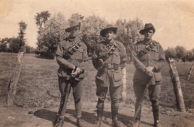 8th/13th Victorian Mounted Rifles Regimental Collection
Photograph - Lighthorsemen
1342 Trooper Allen Davidson of Mt.Egerton Vic; 1341 Trooper George Davidson of Mt Egerton Vic; and 1340 Trooper William Duggan of Albert Park Vic. T he 13th Light Horse Regiment (AIF) was raised t Broadmeadows Victoria in March 1915. Following service at Gallipoli the regiment was broken up with squadrons going to France as Divisional Cavalry Squadrons of 2nd, 4th and 5ht Divisions. The regiment was reformed as firstly 1st Anzac Corps Mounted Troops and lather Australian Corps Mounted Troops.Black and white photograph of three soldiers of the 13th Light Horse Regiment: Troopers Alan Daviidson, George Davidson and Bill Duggan.13th, light horse, world war one, davidson, duggan -
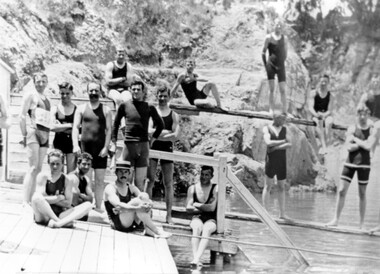 Surrey Hills Historical Society Collection
Photograph, The Surrey Dive c1909-1912
Located in Surrey Park, this photo was taken about 1909-1912. The Surrey Hills Swimming Club formed in 1906 and swimming carnivals were popular from this time. The dive was created from a clay hole formed during brick-making activity at the adjacent brick works. From 1906 Carnivals were popular events. Olympic competitors trained here until Councils built Olympic-sized pools. Photo by William V Hill of Pembroke Street. Donor Mr Bill Dempsey was his nephew.A black and white photograph of a group of 15 young men standing and sitting on diving boards and a platform near some stairs. Most are wearing long trunks covering their thighs and singlets. One person is wearing a boater hat.surrey dive, swimmers, bathing costumes, surrey hills swimming club, box hill brick works, festivals and celebrations, olympics, (mr) william v hill -
!['Save Fairfield Hospital' badge, [1990s]](/media/collectors/5bb42dc221eaf31100db1d3b/items/5c9af03221ea720f88da88fb/item-media/5c9af03f21ea720f88daaa65/item-fit-380x285.jpg) Australian Nursing & Midwifery Federation
Australian Nursing & Midwifery Federation'Save Fairfield Hospital' badge, [1990s]
Fairfield Hospital opened in 1904 as the Queen's Memorial Infectious Diseases Hospital, the first purpose-built isolation hospital for infectious diseases in Victoria. Its 22-acre site was located on a bank of the Yarra River. It was renamed Fairfield Hospital in 1948. In its later years, the hospital was a centre for AIDS treatment in Victoria, and a passionate campaign fought against its planned closure in the 1990s. Fairfield Hospital finally closed in June 1996. One section of the site was gazetted as a Public Park and Memorial Garden (containing an AIDS Garden).Circular white and red plastic badge. Silver metal, plastic-coated, with safety pin fastener adhered to back. Badge printed with the red text 'SAVE FAIRFIELD HOSPITAL'. Silver metal, plastic-coated, with safety pin fastener adhered to back.medicine, health, public institutions, fairfield, victoria, city of darebin, melbourne, politics, political protest, public protest, campaigning, badges, buttons, pins, public health, infectious diseases, aids -
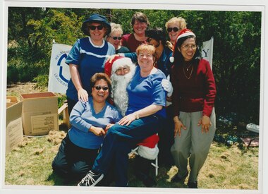 Melbourne Legacy
Photograph - Junior legatee outing, Christmas 2001, 2001
A photo of the mothers at a Christmas Party for junior legatees and the Melbourne Legacy Leadership Group. The photo shows the mothers with Santa Claus (who may be a Legatee). Location is not known. The children were given gifts of sleeping bags by Santa Claus. The photos were mounted in an album of events that happened for Junior Legatees in 2001, including a trip to the Aquarium, a trip to Luna Park, horse riding and fishing and a Melbourne Legacy Leadership Group Christmas party. Melbourne Legacy arranged many events for Junior Legatees to experience. A record of the outings provided for Junior Legatees organised by Legacy.Colour photo of the mothers at the Christmas Party for Junior Legatees and the Legacy Leadership Group 2001.Yellow label printed 'Christmas Party 2001'.junior legatee outing, junior legatees, christmas party, widows -
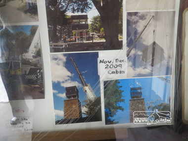 Eltham District Historical Society Inc
Photograph, Liz Pidgeon, Kangaroo Ground War Memorial Park: Photo display, 10 August 2016
Glass cabinet at the base of the stairs at the tower showing colour photographs depicting the installation of the CFA tower in November/ December 2009. As part of a program to acknowledge the Anzac Centenary Nillumbik Shire Council partnered with Yarra Plenty Regional Library to provide a bus tour with commentary of local sites of significance. These included Eltham township, the Shire of Eltham War Memorial at Kangaroo Ground, Christmas Hills, Hurstbridge memorial recreation park and finished at Eltham Library to view the Writing the War exhibtion at Eltham Library Community Gallery. Born Digitalwar memorials, shire of nillumbik, heritage display, kangaroo ground, shire of eltham war memorial, photos -
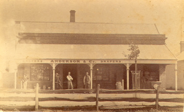 Bacchus Marsh & District Historical Society
Photograph, Anderson's Store, Main Street, Bacchus Marsh circa 1870s-1890s
This store in Main Street Bacchus Marsh was first opened by James Young in November 1866. In October 1869 it was purchased by William Anderson and was operated by members of the Anderson family until 1971. The site of the store was on the southern side of Main Street on the eastern side of Eddie Toole Park. On the opposite side of the street was the site of the former Post Office on the northern side of Main Street. The store was first named the Border Mills Store during James Young's ownership and was later known as the Border Store (Anderson & Co.).Small black and white photograph showing Anderson’s store. It shows a large stone building with a corrugated iron verandah which bears a painted sign of the name of the business: GROCERS. ANDERSON & Co. DRAPERS. Behind a brick parapet rises a hip roof with one chimney visible. Four men stand in casual poses ranged along the verandah. A post and rail fence runs along the road frontage. A tree is planted in an ornamental wrought iron plant protector on the inside of the fence.On the back in decorative print: “ New York Photographic Adelaide Travelling Brand Chas. F. Husband Manager.” In handwriting: Border store built by James Young 1866 owned by Anderson 1869-1972. BMDHS stamp and no. HS 411.shops bacchus marsh vic., anderson's store bacchus marsh, stevenson and mcnicoll 1883 photographs of bacchus marsh and district -
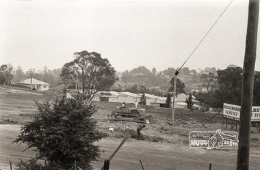 Eltham District Historical Society Inc
Photograph, Sherbourne Road, Para Road and Simms Road at Briar Hill, 3 November 1967, 3 Nov 1967
Viewed from eastern side of Para Road opposite Graham Body Works.. Simms Road is running to the right in front of the old house. The house belongs to Mrs Cameron whose daughter married a DAVEY after which Davey Street is named. Excavation work is being undertaken for the realignment of the Para Road and Sherbourne Road intersection where the current roundabout is located, approximately where the two cars are parked. Mrs Cameron's house and the other are where Montmorency Secondary College is situated. The school opened in 1969.Roll of 35mm black and white negative film, 6 strips Ilford HP3briar hill, cameron, davey, davey road, graham body works, greensborough, montmorency secondary college, sherbourne road, simms road, vw service -
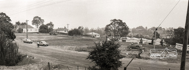 Eltham District Historical Society Inc
Photograph, Sherbourne Road, Para Road and Simms Road at Briar Hill, 3 November 1967, 3 Nov 1967
Viewed from eastern side of Para Road opposite Graham Body Works.. Simms Road is running to the right in front of the old house. The house belongs to Mrs Cameron whose daughter married a DAVEY after which Davey Street is named. Excavation work is being undertaken for the realignment of the Para Road and Sherbourne Road intersection where the current roundabout is located, approximately where the two cars are parked. Mrs Cameron's house and the other are where Montmorency Secondary College is situated. The school opened in 1969.Photostitch from multiple images on roll of film. Roll of 35mm black and white negative film, 6 strips Ilford HP3briar hill, cameron, davey, davey road, graham body works, greensborough, montmorency secondary college, sherbourne road, simms road, vw service -
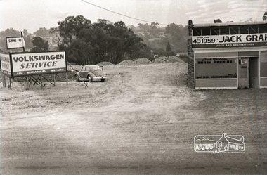 Eltham District Historical Society Inc
Photograph, Sherbourne Road, Para Road and Simms Road at Briar Hill, 3 November 1967, 3 Nov 1967
Viewed from eastern side of Para Road opposite Graham Body Works.. Simms Road is running to the right in front of the old house. The house belongs to Mrs Cameron whose daughter married a DAVEY after which Davey Street is named. Excavation work is being undertaken for the realignment of the Para Road and Sherbourne Road intersection where the current roundabout is located, approximately where the two cars are parked. Mrs Cameron's house and the other are where Montmorency Secondary College is situated. The school opened in 1969.Roll of 35mm black and white negative film, 6 strips Ilford HP3briar hill, cameron, davey, davey road, graham body works, greensborough, montmorency secondary college, sherbourne road, simms road, vw beetle, vw service -
 Eltham District Historical Society Inc
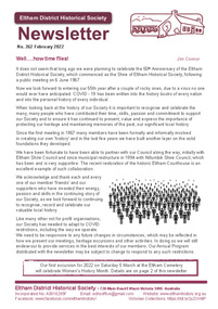
Journal - Newsletter, Newsletter, No. 262 Februray 2022, Feb 2022
Contents: • Well…..how time flies! By Jim Connor • Heritage Excursion – Eltham Cemetery – Saturday 5 March 2022, Women’s History Month • Park On Hill Crest (The Herald 5 Feb 1925) • Eltham Licensing Meeting (The Argus 17 December 1883) • That was then …. By Liz Pidgeon • Local Road and Street Names by Russell Yeoman • Eltham Races (The Argus 15 December 1855) • A 1863 halfpenny! By Calum Ryan • Frederick Edward Falkiner (1820-1881) by Peter Pidgeon • Contacts for the Eltham District Historical Society The Shire of Eltham Historical Society was formed in October 1967. The first newsletter of the Society was issued May 1978 and has been published continuously ever since on a bi-monthly basis. With the cessation of the Shire of Eltham in late 1994, the Society's name was revised to Eltham District Historical Society and this name first appeared with issue No. 103, July 1995. The collection of the Society's newsletters provides a valuable resource on the history of the Society's activities, office bearers and committee members, guest speakers and subjects of historical interest pertinent to the former Shire of Eltham and the Eltham District.A4 newsletter distributed to members (Digital and A4 photocopy)newsletter, eltham district historical society, covid-19, coronavirus pandemic -
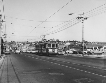
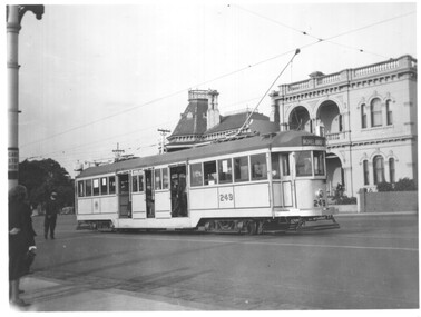 Melbourne Tram Museum
Photograph - Black and white - tram 249 Luna Park Jubilee and negative, 1938
Photograph of W2 249 painted in silver and blue for the silver Jubilee of Luna Park 1938. Tram has the destination of Moreland, route 15. The photo is taken at the intersection Fitzroy St and The Esplanade. There is a compulsory tram stop sign on the left side of the photo. Photo also in item 4601, TAP73. This view has not been cropped. Photo by either Peter Duckett or Ray Pearson. The tram is now owned by the Sydney Tramway Museum and was painted a burgundy colour to promote a heritage tram line in Canberra in 2001. See item 5602. Demonstrates a specially painted tram for a Luna Park event.Black and white photograph on Kodak Velox paper.trams, tramways, w2 class, tram 249, luna park, the esplandade -
 Melbourne Tram Museum
Negative - Copy - CW5 685 Hawthorn Road, Balaclava Junction, early to mid 1940s
Black and white photograph of CW5 685 in Hawthorn Road with Caulfield Park in the background, just before Balaclava Junction. Tram has white strips on the bumper and under the cab windows. Photo during the early to mid 1940's. Tram has an Auxiliary board "Via Dandenong Rd" and showing, Route 67. At the time, Route 67 ran from St Kilda ran from Balaclava Junction to St Kilda, Acland St via Dandenong Road. Ceased in 1955. See 3599 for a poor print.Yields information about the use of L class trams.Copy negative of a black and white photographtramcars, tramways, caulfield, hawthorn road, cw5 class, balaclava junction, route 67., tram 685 -
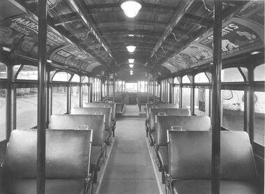 Melbourne Tram Museum
Photograph - Y1 class interior photograph, Sutcliffe Pty Ltd, early 1930s
Black and white photograph of the interior a Y1 class tram car, photographed at Glenhuntly Depot. Shows general arrangements of seats, light defuses and internal advertising. Part of W2 class No. 550 is in the background. Advertisements for: Brockhoff's Biscuits, Senitts Ice Cream, Saunders and Madison Utility Chairs of 309 Collins St Melbourne. Also note the paper notice on the window promoting Albert Park. On rear is Sutcliffe Photographers stamp. See item 7672 for another similar photograph. Destination City, 4th Edition and 5th edition.Yields information about the interior of a Y1 class tramcar.Black and white print with photographer's detail on the rear."Sutcliffe" photographers stamp and in pencil "class Y1"tramways, mmtb, y1 class, interiors, trams, tram 550, w2 class, advertisements, glenhuntly depot -
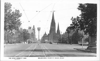 Melbourne Tram Museum
Postcard, Rose Stereograph Co, "Melbourne from St Kilda Road", late 1930s
Rose Series postcard No. P 3636, titled "Melbourne from St Kilda Road", looking north from just south of Alexandra Avenue. Note how the tram tracks are widened to pass around the center of the road light standard which appears to be marked as a tram stop. In front of the photo, a tram crossover can be seen. There is a tour bus parked at the start of Alexandra Avenue. See item 8044 for a similar view. The Edmund Fitz Gibbon Memorial is on the right in its original position in St. Kilda Road.Yields information Swanston Street and St Kilda Road in the late 1930s.Postcard - printed real photograph with Rose Stereograph Co. name on the rear.tramways, trams, st kilda road, alexandra ave -
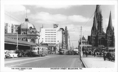 Melbourne Tram Museum
Postcard, Rose Stereograph Co, "Swanston Street Melbourne", early 1940s
Rose Series postcard No. P 3288 titled "Swanston Street Melbourne", looking north from just past (or south) of Batman Ave. There are five trams in the view and one private Reo bus. W2 class tram 452 (route 64 - City). The trams have a white strip under the driver's windows indicating the war time black out measure. The sign board advertising tram routes to Wattle Park, Burwood etc can be seen above the footpath leading to Batman Ave.Yields information about Swanston St. at the intersection with Batman Ave.Postcard - printed real photograph with Rose Stereograph Co. name on the rear.Has "K J Magor" stamp on rear.trams, tramways, w2 class, swanston st, bus, batman ave, tram 452, route 64, world war ii -
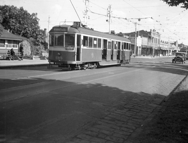
 Melbourne Tram Museum
Photograph - W5 class 721 High Street, St Kilda, 1970s
Photograph of W5 class 721 city bound on route 67 ascends an uphill grade on a busy thoroughfare with numerous motor vehicles parked on vacant allotments along the southwest edge of the roadway. This is likely High Street, St Kilda at the commencement of road-widening works in the early 1970s. These works were to widen the narrow High Street between the wider Brighton Road and the newly rebuilt St Kilda Junction. Properties on the northeast edge of High Street remained. In these years the Carnegie route number changed from 4 to 67.Yields information about increase in motor vehicle traffic Black and white photograph with no notetram 721, route 4, route 67, high street st kilda, st kilda junction, road widening, brighton road, w5 class -
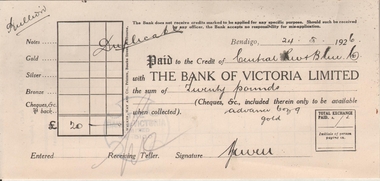 Bendigo Historical Society Inc.
Administrative record - Bank of Victoria credit for Central Red, White and Blue Gold Mine, 1917 - 1920
Bank of Victoria Limited (1852 - 1927) From 1852 Melbourne, Victoria To 1927 Registered in Victoria in 1852 by an Act of the Legislative Council, the company commenced operations in January 1853 as the Bank of Victoria. In 1889 the business was registered under the Victorian Companies Act and became known as the Bank of Victoria Limited. 1927 saw the company merge with the Commercial Banking Company of Sydney Ltd. https://www.gabr.net.au/biogs/ABE0224b.htm (Guide to Australian Business Records) The Bank of Victoria, Sandhurst, was in View Street on the corner adjoining Rosalind Park. Pay-in slip for gold bullion lodged with the Bank of Victoria Limited to the value of 'twenty pounds', dated 24th May 1926. Written across pay-in slip if 'bullion' on the top left hand corner, and 'duplicate' written broadly across the document. bendigo, margaret roberts, , goldmining, central red white and blue gold mine, bullion, gold, bank of victoria limited -
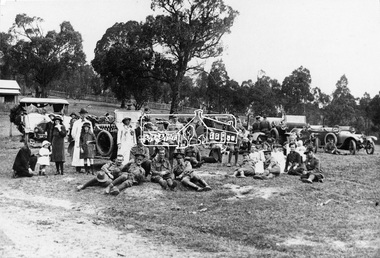 Eltham District Historical Society Inc
Photograph, Returned soldiers picnic, Police Paddocks, Queenstown, c.1916, c.1916
Possibly a picnic for returned servicemen from Gallipoli. This photo was taken in front of the Police Paddocks with the police station on the left. Model T Fords parked with soldiers, drivers and locals resting on the police paddock in front of the Queenstown (St Andrews) station. The RACV Volunteer Motor Corps service during World War One was the reason the organisation was granted its Royal prefix. Automobile Club of Victoria members volunteered their time and vehicles to collect returning soldiers and nurses from ships at Princes Pier, Port Melbourne. Trips were also often arranged for convalescing soldiers to country areas for picnics and to “revive spirits”. The soldiers were also picked up from the Austin Hospital in Heidelberg and Mont Park Military Hospital in Macleod. Queenstown (St Andrews) was a common picnic spot. The Evelyn Observer reported on June 9. 1916 "Some 75 returned soldiers visited Queenstown on Sunday, 28th ult., and were hospitably entertained by local residents who had provided refreshments sufficient for 150. Mr. Milne in an appropriate speech welcomed the soldiers, and Mr. Robison suitably responded.” The photo was reproduced page 108 of “The Diamond Valley Story" by Diane H. Edwards.This photo forms part of a collection of photographs gathered by the Shire of Eltham for their centenary project book,"Pioneers and Painters: 100 years of the Shire of Eltham" by Alan Marshall (1971). The collection of over 500 images is held in partnership between Eltham District Historical Society and Yarra Plenty Regional Library (Eltham Library) and is now formally known as the 'The Shire of Eltham Pioneers Photograph Collection.' It is significant in being the first community sourced collection representing the places and people of the Shire's first one hundred years.Digital image, 16 x 24 and 12.5 x 9 cm and 4 x 5 inch B&W Neg sepp, shire of eltham pioneers photograph collection, queenstown, cars, police station, st andrews, soldiers, picnic, exhibition yprl 2019-12, gallipoli, model t ford, pioneers and painters, police paddocks, retuned soldiers -
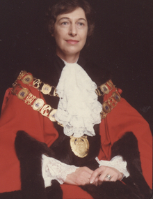 Kew Historical Society Inc
Photograph - Cr Jill O'Brien, Mayor of Kew 1983-84
Born in Bendigo and trained as a nurse in the 1950s, Sonia Jill O’Brien devoted a lifetime to social and environmental issues at both the state and local level. From her work in the 1960s with the Family Planning Association of Victoria, of which she was a founding member, through to the 1990s as a member of the Ethics Committee of the Department of Health, she supported efforts to improve women’s health and reproductive rights. At the local level she was most active on committees that worked to save the natural and built environment. The Power-line Action Group, the Studley Park Conservation Society, and the Yarra Bend Park Trust all benefitted from her indefatigable endeavours as well her vision. In 1980, Jill O’Brien successfully stood for the Kew City Council and served as Mayor in 1983 and 1984. With an eye to preserving the past as well as guarding the future, she had the Mayoral robes restored and in 1980 and 1981 was president of the Kew Historical Society. The preservation and restoration of Villa Alba in Walmer Street owes much to her determined efforts throughout the 1980s. On Council, she chaired a number of committees involved in the saving of the Kew River Parklands from the proposed transmission line of the SEC. To this end, she was the Council representative on the Merri Yarra Municipal Protection Committee.Rare colour photograph, used as the official mayoral portrait of Cr Jill O'Brien.Formal civic portrait of Cr Jill O'Brien in red mayoral robes wearing lace jabot and cuffs. The portrait is part of the larger Jill O'Brien Collection donated by her daughters.cr jill o'brien, city of kew -- mayors, mayoral portraits -- city of kew