Showing 1026 items matching " channel"
-
 Eltham District Historical Society Inc
Photograph, Liz Pidgeon, Heritage Excursion; Maroondah Aqueduct, 3 September 2016, 3 September 2016
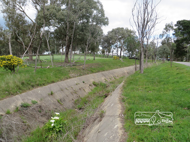
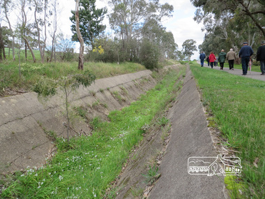
... It was 66 km in length, made up of 41 km of open channel, 10 km of tunnel through hills and 15 km of pipeline across stream valleys known as inverted siphons. ...It was 66 km in length, made up of 41 km of open channel, 10 km of tunnel through hills and 15 km of pipeline across stream valleys known as inverted siphons. ...Newsletter No., 229, August 2016 Heritage Excursion - Maroondah Aqueduct Walk - Saturday 3rd September The Maroondah Aqueduct was once a major link in Melbourne’s water supply system. It was built between 1886 and 1891 to transfer water from the Watts River near Healesville to the Preston Reservoir. It was 66 km in length, made up of 41 km of open channel, 10 km of tunnel through hills and 15 km of pipeline across stream valleys known as inverted siphons. The section of the aqueduct through the Eltham area has been abandoned since the 1980s but the open channel has largely been retained. A recreational path follows the aqueduct reserve. For our excursion on 3rd September we intend to walk along the section of the aqueduct adjacent to Allendale Road. This is a section not visited on previous excursions and includes the transition from open channel to the inverted siphon across the Diamond Creek valley. Apart from the aqueduct itself the main feature of the walk is the extensive views across Eltham North and Diamond Creek. Along the way we will talk about the history of the aqueduct and the area. This easy walk is about 3 km return and will take 2 to 2.5 hours. It will start at 2pm at the junction of Allendale Road with Godber Road and Zig Zag Road North, officially Diamond Creek, but on the northern boundary of Eltham. (Melway ref.12 B10). Born Digitalmaroondah aqueduct, eltham north, activities, eltham district historical society, heritage excursion, aqueduct trail, open channel -
 Eltham District Historical Society Inc
Photograph, Liz Pidgeon, Heritage Excursion; Maroondah Aqueduct, 3 September 2016, 3 September 2016
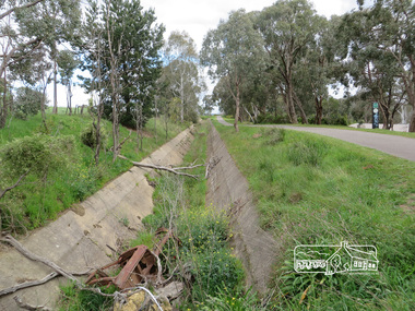
... It was 66 km in length, made up of 41 km of open channel, 10 km of tunnel through hills and 15 km of pipeline across stream valleys known as inverted siphons. ...It was 66 km in length, made up of 41 km of open channel, 10 km of tunnel through hills and 15 km of pipeline across stream valleys known as inverted siphons. ...Newsletter No., 229, August 2016 Heritage Excursion - Maroondah Aqueduct Walk - Saturday 3rd September The Maroondah Aqueduct was once a major link in Melbourne’s water supply system. It was built between 1886 and 1891 to transfer water from the Watts River near Healesville to the Preston Reservoir. It was 66 km in length, made up of 41 km of open channel, 10 km of tunnel through hills and 15 km of pipeline across stream valleys known as inverted siphons. The section of the aqueduct through the Eltham area has been abandoned since the 1980s but the open channel has largely been retained. A recreational path follows the aqueduct reserve. For our excursion on 3rd September we intend to walk along the section of the aqueduct adjacent to Allendale Road. This is a section not visited on previous excursions and includes the transition from open channel to the inverted siphon across the Diamond Creek valley. Apart from the aqueduct itself the main feature of the walk is the extensive views across Eltham North and Diamond Creek. Along the way we will talk about the history of the aqueduct and the area. This easy walk is about 3 km return and will take 2 to 2.5 hours. It will start at 2pm at the junction of Allendale Road with Godber Road and Zig Zag Road North, officially Diamond Creek, but on the northern boundary of Eltham. (Melway ref.12 B10). Born Digitalmaroondah aqueduct, eltham north, activities, eltham district historical society, heritage excursion, open channel, rubbish, aqueduct trail -
 Eltham District Historical Society Inc
Photograph, Liz Pidgeon, Heritage Excursion; Maroondah Aqueduct, 3 September 2016, 3 September 2016
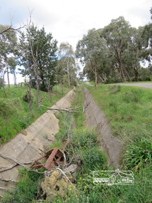
... It was 66 km in length, made up of 41 km of open channel, 10 km of tunnel through hills and 15 km of pipeline across stream valleys known as inverted siphons. ...It was 66 km in length, made up of 41 km of open channel, 10 km of tunnel through hills and 15 km of pipeline across stream valleys known as inverted siphons. ...Newsletter No., 229, August 2016 Heritage Excursion - Maroondah Aqueduct Walk - Saturday 3rd September The Maroondah Aqueduct was once a major link in Melbourne’s water supply system. It was built between 1886 and 1891 to transfer water from the Watts River near Healesville to the Preston Reservoir. It was 66 km in length, made up of 41 km of open channel, 10 km of tunnel through hills and 15 km of pipeline across stream valleys known as inverted siphons. The section of the aqueduct through the Eltham area has been abandoned since the 1980s but the open channel has largely been retained. A recreational path follows the aqueduct reserve. For our excursion on 3rd September we intend to walk along the section of the aqueduct adjacent to Allendale Road. This is a section not visited on previous excursions and includes the transition from open channel to the inverted siphon across the Diamond Creek valley. Apart from the aqueduct itself the main feature of the walk is the extensive views across Eltham North and Diamond Creek. Along the way we will talk about the history of the aqueduct and the area. This easy walk is about 3 km return and will take 2 to 2.5 hours. It will start at 2pm at the junction of Allendale Road with Godber Road and Zig Zag Road North, officially Diamond Creek, but on the northern boundary of Eltham. (Melway ref.12 B10). Born Digitalmaroondah aqueduct, eltham north, activities, eltham district historical society, heritage excursion, open channel, rubbish, aqueduct trail -
 Eltham District Historical Society Inc
Photograph, Liz Pidgeon, Heritage Excursion; Maroondah Aqueduct, 3 September 2016, 3 September 2016
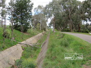
... It was 66 km in length, made up of 41 km of open channel, 10 km of tunnel through hills and 15 km of pipeline across stream valleys known as inverted siphons. ...It was 66 km in length, made up of 41 km of open channel, 10 km of tunnel through hills and 15 km of pipeline across stream valleys known as inverted siphons. ...Newsletter No., 229, August 2016 Heritage Excursion - Maroondah Aqueduct Walk - Saturday 3rd September The Maroondah Aqueduct was once a major link in Melbourne’s water supply system. It was built between 1886 and 1891 to transfer water from the Watts River near Healesville to the Preston Reservoir. It was 66 km in length, made up of 41 km of open channel, 10 km of tunnel through hills and 15 km of pipeline across stream valleys known as inverted siphons. The section of the aqueduct through the Eltham area has been abandoned since the 1980s but the open channel has largely been retained. A recreational path follows the aqueduct reserve. For our excursion on 3rd September we intend to walk along the section of the aqueduct adjacent to Allendale Road. This is a section not visited on previous excursions and includes the transition from open channel to the inverted siphon across the Diamond Creek valley. Apart from the aqueduct itself the main feature of the walk is the extensive views across Eltham North and Diamond Creek. Along the way we will talk about the history of the aqueduct and the area. This easy walk is about 3 km return and will take 2 to 2.5 hours. It will start at 2pm at the junction of Allendale Road with Godber Road and Zig Zag Road North, officially Diamond Creek, but on the northern boundary of Eltham. (Melway ref.12 B10). Born Digitalmaroondah aqueduct, eltham north, activities, eltham district historical society, heritage excursion, aqueduct trail, open channel -
 Eltham District Historical Society Inc
Photograph, Liz Pidgeon, Heritage Excursion; Maroondah Aqueduct, 3 September 2016, 3 September 2016
... It was 66 km in length, made up of 41 km of open channel, 10 km of tunnel through hills and 15 km of pipeline across stream valleys known as inverted siphons. ...It was 66 km in length, made up of 41 km of open channel, 10 km of tunnel through hills and 15 km of pipeline across stream valleys known as inverted siphons. ...Newsletter No., 229, August 2016 Heritage Excursion - Maroondah Aqueduct Walk - Saturday 3rd September The Maroondah Aqueduct was once a major link in Melbourne’s water supply system. It was built between 1886 and 1891 to transfer water from the Watts River near Healesville to the Preston Reservoir. It was 66 km in length, made up of 41 km of open channel, 10 km of tunnel through hills and 15 km of pipeline across stream valleys known as inverted siphons. The section of the aqueduct through the Eltham area has been abandoned since the 1980s but the open channel has largely been retained. A recreational path follows the aqueduct reserve. For our excursion on 3rd September we intend to walk along the section of the aqueduct adjacent to Allendale Road. This is a section not visited on previous excursions and includes the transition from open channel to the inverted siphon across the Diamond Creek valley. Apart from the aqueduct itself the main feature of the walk is the extensive views across Eltham North and Diamond Creek. Along the way we will talk about the history of the aqueduct and the area. This easy walk is about 3 km return and will take 2 to 2.5 hours. It will start at 2pm at the junction of Allendale Road with Godber Road and Zig Zag Road North, officially Diamond Creek, but on the northern boundary of Eltham. (Melway ref.12 B10). Born Digitalmaroondah aqueduct, eltham north, activities, eltham district historical society, heritage excursion, aqueduct trail, spring -
 Kiewa Valley Historical Society
Photograph - Folder of Photographs (KVHS 1150 A - F) – Photocopied set of black and white photographs from the display folder (pages 1 - 8) put together by KVHS to document life on the Kiewa Valley Hydro-electric Scheme
... Large A3 size spiral bound display folder containing 21 of 58 pages of photocopied black and white photographs of various aspects of the early days of the Kiewa Valley Hydro-electric scheme including equipment, various work sites and photographs of workers and their families. 1-Front page; 2-Security gate at Mt Beauty Camp; 3-Channel 1 on East Kiewa River; 4-Junction Dam – Diversion Tunnel Inlet; 5-Sawmill; 6- Homan’s Gap Sawmill; 7 Junction Dam: 8-Homan Dam Site-Diamond Drilling on River Buttress; 9- Homan Dam Site View Upstream 10-Homan Dam Investigation Camp ...Diverting East Kiewa River into Channel Page number 1 4-STATE ELECTRICITY COMMISSION OF VICTORIA Date: 5.4.40 Time: Noon No K58 Kiewa Hydro Electric Works. ...Diverting East Kiewa River into Channel Page number 1 4-STATE ELECTRICITY COMMISSION OF VICTORIA Date: 5.4.40 Time: Noon No K58 Kiewa Hydro Electric Works. ...Although the Kiewa Hydro-Electric Scheme was first proposed in 1911, construction did not commence until 1938. As part of the push to cut electricity costs and diversify supply, the Victorian Government (circa 1930) initiated the conversion from primarily brown coal supply to hydro – electricity. Field investigations during the 1940’s resulted in a new proposal for a scheme that had more than double the capacity of the 1938 scheme. The Kiewa Hydroelectric Scheme became the largest scheme of its kind in the State Of Victoria and the second largest scheme in Australia. The number of personnel involved in the planning and construction of the scheme increased dramatically. During the late 1940’s, most activity centred around the construction of the West Kiewa Power Station, Rocky Valley Reservoir, McKay Creek Power Station and the Bogong Creek Aqueduct.A common thread across all the larger hydro scheme constructions was the need for workers, both qualified and unqualified who came from around the world seeking a new life for themselves and their families. New accommodation and facilities were required for the army of workers engaged in construction in often remote and wild areas. The SEC had a high demand for timber, and set up the first of a number of sawmills at Bogong Creek in 1939 and set up the first hardwood logging in the headwaters of the Kiewa River. These new ‘towns’ such as Mt Beauty and Bogong, survived, serving the needs of operational personnel and their families, and expanding with growth of new industries. Mount Beauty, and to a lesser extent Bogong, are among these places. Large A3 size spiral bound display folder containing 21 of 58 pages of photocopied black and white photographs of various aspects of the early days of the Kiewa Valley Hydro-electric scheme including equipment, various work sites and photographs of workers and their families. 1-Front page; 2-Security gate at Mt Beauty Camp; 3-Channel 1 on East Kiewa River; 4-Junction Dam – Diversion Tunnel Inlet; 5-Sawmill; 6- Homan’s Gap Sawmill; 7 Junction Dam: 8-Homan Dam Site-Diamond Drilling on River Buttress; 9- Homan Dam Site View Upstream 10-Homan Dam Investigation Camp 1-Windsor & Newton Visual Diary 60 sheet (120 pages) 11’ x 14’ 280 x 356mm 110 GSM Acid Free Drawing Paper 2-1940-Security Gate on Mt Beauty side of Kiewa River bridge. Part of old Mt Beauty camp and mess in background 3- STATE ELECTRICITY COMMISSION OF VICTORIA Date; 11.3.40 Time: 10.30am No K35 Kiewa Hydro Electric Works. Diverting East Kiewa River into Channel Page number 1 4-STATE ELECTRICITY COMMISSION OF VICTORIA Date: 5.4.40 Time: Noon No K58 Kiewa Hydro Electric Works. Junction Dam – Diversion Tunnel Inlet – Normal Flow Page number 2 5- STATE ELECTRICITY COMMISSION OF VICTORIA Date: 19.8.42 Time: 2.30pm No K883 Kiewa Hydro Electric Works. Sawmill – General View Page number 3 6- STATE ELECTRICITY COMMISSION OF VICTORIA Date: 12.1.42 Time: 2.00pm No K540 Kiewa Hydro Electric Works. Homan’s Gap Sawmill – General View Page number 4 7- STATE ELECTRICITY COMMISSION OF VICTORIA Date: 12.1.42 Time: 2.00pm No K540 Kiewa Hydro Electric Works. Junction Dam – General View looking upstream Page number 5 8- STATE ELECTRICITY COMMISSION OF VICTORIA Date: 16.11.45 Time: 10.32amm No K52153 Kiewa Hydro Electric Works Homan Dam Site – Diamond Drilling on River Buttress Page number 6 9-STATE ELECTRICITY COMMISSION OF VICTORIA Date: 15.1.45 Time: 4.10pm No K1781 Kiewa Hydro Electric Works Homan Dam Site – View Upstream Page number 7 10- STATE ELECTRICITY COMMISSION OF VICTORIA Date: 15.1.45 Time: 4.10pm No K1781 Kiewa Hydro Electric Works Homan Dam Investigation Camp 1944 – 1945 Page number 8 secv; kiewa hydro electric scheme; mt beauty; bogong; construction work; -
 Ballarat Heritage Services
Digital photographs, L.J. Gervasoni, Yarra River Melbourne Docklands willamstown yacht club, 2015
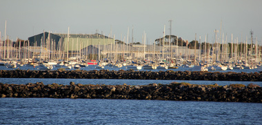
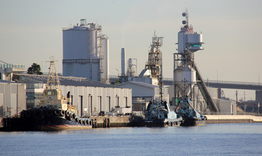
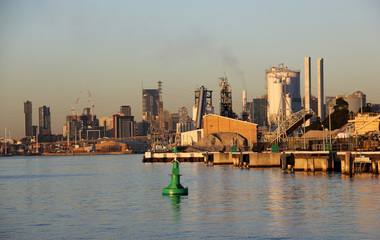
... ...channel...Ballarat Heritage Services PO Box 2209 Bakery Hill Post Office goldfields yarra river melbourne docklands yarra river dock docklands shipping port channel water ship yachts williamstown Digital Images Yarra River Melbourne Docklands willamstown yacht club Digital photographs L.J. ...Digital Imagesyarra river melbourne docklands, yarra river, dock, docklands, shipping, port, channel, water, ship, yachts, williamstown -
 Ballarat Heritage Services
Digital photographs, L.J. Gervasoni, Yarra River Melbourne Docklands tug boats, 2015
... ...channel...Ballarat Heritage Services PO Box 2209 Bakery Hill Post Office goldfields yarra river melbourne docklands yarra river dock docklands shipping port channel water ship tug boats tugs Digital Images Yarra River Melbourne Docklands tug boats Digital photographs L.J. ...Digital Imagesyarra river melbourne docklands, yarra river, dock, docklands, shipping, port, channel, water, ship, tug boats, tugs -
 Ballarat Heritage Services
digital photographs, L.J. Gervasoni, Yarra River Melbourne Docklands wharves and markers, 2015
... ...channel...Ballarat Heritage Services PO Box 2209 Bakery Hill Post Office goldfields yarra river melbourne docklands yarra river dock docklands shipping port channel water ship wharf channel marker Digital Images Yarra River Melbourne Docklands wharves and markers digital photographs L.J. ...Digital Imagesyarra river melbourne docklands, yarra river, dock, docklands, shipping, port, channel, water, ship, wharf, channel marker -
 Kiewa Valley Historical Society
Photograph - Folder of Photographs – Photocopied set of black and white photographs (pages 9 - 18) from the display folder put together by KVHS to document life on the Kiewa Valley Hydro-electric Scheme
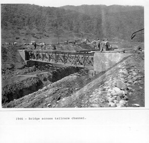
... PHYSICAL: Large A3 size spiral bound display folder containing 21 pages of photocopied black and white photographs of various aspects of the early days of the Kiewa Valley Hydro-electric scheme including equipment, various work sites and photographs of workers and their families. 1-Bridge across Tailrace Channel 1946 2-New Mess building, Mt Beauty 3-Homan’s Gap Saw Mill 4- Diamond Drilling Plant – Big Hill 5-Rocky Valley Camp-Mess Building 6-Parlimentary Party at Rocky Valley 7-No.4 Headrace Tunnel 8- Allis-Chalmers Tractor School 9- SECV Heavy Machinery lined up by road 10- No. 5 Raceline – Balasting Track with improvised truck ...1-1946 – Bridge across tailrace channel Page number 9 2-New mess building, Mt Beauty 6.4.46 Page number 10 3- STATE ELECTRICITY COMMISSION OF VICTORIA Date: 10.1.47 Time: 11.40am No K2271 Kiewa Hydro Electric Works Homan’s Gap Saw Mill – Rip Saw Page number 11 4- STATE ELECTRICITY COMMISSION OF VICTORIA Date: 5.10.47 Time: 11am No K4111 Kiewa Hydro Electric Works Diamond Drilling Plant – Big Hill Page number 12 5- STATE ELECTRICITY COMMISSION OF VICTORIA Date: 11.2.48 Time: 3pm No K4277 Kiewa Hydro Electric Works Rocky Valley Camp-Mess Building Page number 13 6- STATE ELECTRICITY COMMISSION OF VICTORIA Date: 15.4.48 Time: 4.30pm No K4397 Kiewa Hydro Electric Works Parlimentary Party at Rocky Valley Page number 14 7- STATE ELECTRICITY COMMISSION OF VICTORIA Date: 22.8.48 Time: 9am No K4668 Kiewa Hydro Electric Works General view of No.4 Headrace Tunnel Page number 15 8-STATE ELECTRICITY COMMISSION OF VICTORIA Date: 5.9.49 Time: 10am No K5180 Kiewa Hydro Electric Works Allis-Chalmers Tractor School – HD 19, Mr I Crossthwaite at Controls Page number 16 9- No markings Page number 17 10- STATE ELECTRICITY COMMISSION OF VICTORIA Date: 7,12.49 Time: 4pm No K5423 Kiewa Hydro Electric Works No. 5 Raceline – Balasting Track with improvised truck. ...Page number 18 PHYSICAL: Large A3 size spiral bound display folder containing 21 pages of photocopied black and white photographs of various aspects of the early days of the Kiewa Valley Hydro-electric scheme including equipment, various work sites and photographs of workers and their families. 1-Bridge across Tailrace Channel 1946 2-New Mess building, Mt Beauty 3-Homan’s Gap Saw Mill 4- Diamond Drilling Plant – Big Hill 5-Rocky Valley Camp-Mess Building 6-Parlimentary Party at Rocky Valley 7-No.4 Headrace Tunnel 8- Allis-Chalmers Tractor School 9- SECV Heavy Machinery lined up by road 10- No. 5 Raceline – Balasting Track with improvised truck Photograph Folder of Photographs – Photocopied set of black and white photographs (pages 9 - 18) from the display folder put together by KVHS to document life on the Kiewa Valley Hydro-electric Scheme ...Although the Kiewa Hydro-Electric Scheme was first proposed in 1911, construction did not commence until 1938. As part of the push to cut electricity costs and diversify supply, the Victorian Government (circa 1930) initiated the conversion from primarily brown coal supply to hydro – electricity. Field investigations during the 1940’s resulted in a new proposal for a scheme that had more than double the capacity of the 1938 scheme. The Kiewa Hydroelectric Scheme became the largest scheme of its kind in the State Of Victoria and the second largest scheme in Australia. The number of personnel involved in the planning and construction of the scheme increased dramatically. During the late 1940’s, most activity centred around the construction of the West Kiewa Power Station, Rocky Valley Reservoir, McKay Creek Power Station and the Bogong Creek Aqueduct.A common thread across all the larger hydro scheme constructions was the need for workers, both qualified and unqualified who came from around the world seeking a new life for themselves and their families. New accommodation and facilities were required for the army of workers engaged in construction in often remote and wild areas. The SEC had a high demand for timber, and set up the first of a number of sawmills at Bogong Creek in 1939 and set up the first hardwood logging in the headwaters of the Kiewa River. These new ‘towns’ such as Mt Beauty and Bogong, survived, serving the needs of operational personnel and their families, and expanding with growth of new industries. Mount Beauty, and to a lesser extent Bogong, are among these places. PHYSICAL: Large A3 size spiral bound display folder containing 21 pages of photocopied black and white photographs of various aspects of the early days of the Kiewa Valley Hydro-electric scheme including equipment, various work sites and photographs of workers and their families. 1-Bridge across Tailrace Channel 1946 2-New Mess building, Mt Beauty 3-Homan’s Gap Saw Mill 4- Diamond Drilling Plant – Big Hill 5-Rocky Valley Camp-Mess Building 6-Parlimentary Party at Rocky Valley 7-No.4 Headrace Tunnel 8- Allis-Chalmers Tractor School 9- SECV Heavy Machinery lined up by road 10- No. 5 Raceline – Balasting Track with improvised truck 1-1946 – Bridge across tailrace channel Page number 9 2-New mess building, Mt Beauty 6.4.46 Page number 10 3- STATE ELECTRICITY COMMISSION OF VICTORIA Date: 10.1.47 Time: 11.40am No K2271 Kiewa Hydro Electric Works Homan’s Gap Saw Mill – Rip Saw Page number 11 4- STATE ELECTRICITY COMMISSION OF VICTORIA Date: 5.10.47 Time: 11am No K4111 Kiewa Hydro Electric Works Diamond Drilling Plant – Big Hill Page number 12 5- STATE ELECTRICITY COMMISSION OF VICTORIA Date: 11.2.48 Time: 3pm No K4277 Kiewa Hydro Electric Works Rocky Valley Camp-Mess Building Page number 13 6- STATE ELECTRICITY COMMISSION OF VICTORIA Date: 15.4.48 Time: 4.30pm No K4397 Kiewa Hydro Electric Works Parlimentary Party at Rocky Valley Page number 14 7- STATE ELECTRICITY COMMISSION OF VICTORIA Date: 22.8.48 Time: 9am No K4668 Kiewa Hydro Electric Works General view of No.4 Headrace Tunnel Page number 15 8-STATE ELECTRICITY COMMISSION OF VICTORIA Date: 5.9.49 Time: 10am No K5180 Kiewa Hydro Electric Works Allis-Chalmers Tractor School – HD 19, Mr I Crossthwaite at Controls Page number 16 9- No markings Page number 17 10- STATE ELECTRICITY COMMISSION OF VICTORIA Date: 7,12.49 Time: 4pm No K5423 Kiewa Hydro Electric Works No. 5 Raceline – Balasting Track with improvised truck. Page number 18 secv; kiewa hydro electric scheme; mt beauty; bogong; construction area -
 Orbost & District Historical Society
plan, December 1968
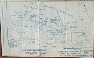
... Works included: clearing the river channel and blocking ‘gulches’. The meander was cut-off in 1931, as part of the Orbost East Drainage Scheme and further developed after 1934 floods and again in the early 1950s when levee banks and a regulator were constructed. ...Works included: clearing the river channel and blocking ‘gulches’. The meander was cut-off in 1931, as part of the Orbost East Drainage Scheme and further developed after 1934 floods and again in the early 1950s when levee banks and a regulator were constructed. ...Brodribb floodplain regularly inundated in the late 1800s and early 1900s. Works included: clearing the river channel and blocking ‘gulches’. The meander was cut-off in 1931, as part of the Orbost East Drainage Scheme and further developed after 1934 floods and again in the early 1950s when levee banks and a regulator were constructed. (ref. East Gippsland Catchment Management)This is a useful reference tool.A hand-drawn plan of the layout of the levee banks of the Old Brodribb River.brodribb-river map plan-levee-banks -
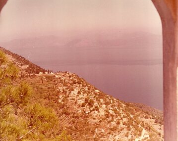 Ithacan Historical Society
Photograph, View of Exoghi and Afales Bay - Ithaca, c1970s
... During the Middle Ages and at the beginning of the Venetian rule, it was one of the most populated villages of the island, offering safety from the pirates, and an excellent view of the channel, the sea and the bays around the northern Ithaca....During the Middle Ages and at the beginning of the Venetian rule, it was one of the most populated villages of the island, offering safety from the pirates, and an excellent view of the channel, the sea and the bays around the northern Ithaca. ...At an altitude of 340m, the picturesque village of Exogh in northern Ithaca, lies on the Homeric mountain of Neion. The village overlooks Aphales Bay and across the water the neighbouring island of Lefkada. During the Middle Ages and at the beginning of the Venetian rule, it was one of the most populated villages of the island, offering safety from the pirates, and an excellent view of the channel, the sea and the bays around the northern Ithaca.Some of the earliest Ithacan settlers in Melbourne were from the mountain village of Exoghi, including the founding president AJ.J. Lekatsas (Lucas). The village now has very few permanent residents with most having migrated or moved to the cities of Greece. A coloured photograph of a view overlooking the village of Exoghi and Aphales Bay on the island of Ithaca. The photograph was taken from the bell tower of the church of Panagias (the Virgin/Our Lady) sta Pernarakia located at the top of the mountain. The mountains which are visible across the skyline are the neighbouring island of Lefkada. mountain villages, ithaca -
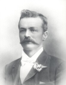 City of Kingston
Photograph - Black and white, Francis Thomas Le Page
... Frank is the oldest child of Nicholas and Rachel (nee Addy), who arrived in Melbourne in 1852 from Guernsey in the Channel Islands. Nicholas was a tailor and Rachel was a dressmaker. ...Frank is the oldest child of Nicholas and Rachel (nee Addy), who arrived in Melbourne in 1852 from Guernsey in the Channel Islands. Nicholas was a tailor and Rachel was a dressmaker. ...Photographic portrait of Francis (Frank) Thomas Le Page. Frank is the oldest child of Nicholas and Rachel (nee Addy), who arrived in Melbourne in 1852 from Guernsey in the Channel Islands. Nicholas was a tailor and Rachel was a dressmaker. They originally made their home in Prahran and set up a business but about two years later decided to take up market gardening. The Le Page family bought property in the Two Acre Village, Cheltenham. They had nine other children. At 14 years of age Frank was driving his father’s horse and dray to Melbourne with the vegetables they grew - standing backed in to the footpath in Little Collins Street, at the old Eastern Market. At 18 years of age, and the other members of the family growing up, Francis decided to seek work outside, and was employed as a gardener by Mr Budd, who conducted the Brighton Grammar School. It was whilst employed there that the late Sir Thomas Bent and he became friends, a friendship which lasted throughout their lives. Sir Thomas was then on the land also. Frank was an active member of social and sporting groups in the region. In 1876 Frank married Mary Geraghty and they made Cheltenham their home. He became a councillor for the then Shire of Moorabbin, a position he held for 25 years, and in 1902 was elected President of the Shire of Moorabbin. He was also a Justice of the Peace and occupied the bench at the Cheltenham Court. The next generation of Le Pages continued to be heavily involved in the civic life of the region with Frank and Mary's son Everest being elected mayor twice.Black and white image of Francis (Frank) Thomas Le Page. -
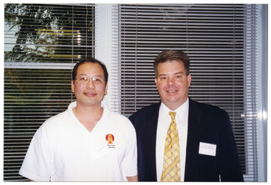 Musculoskeletal Health Australia (now held by the Glen Eira Historical Society)
Photograph - Group photo, 2001
... The program was broadcast on Community Television station, Channel 31. In this photo, CharlesTsui-Po (Tai Chi Master) and Peter Johnson (Renaissance Television) pose for a photo at the morning tea event....The program was broadcast on Community Television station, Channel 31. In this photo, CharlesTsui-Po (Tai Chi Master) and Peter Johnson (Renaissance Television) pose for a photo at the morning tea event. arthritis foundation of victoria afv move it or lose it television program television series broadcast television community television channel 31 audiovisual morning tea peter johnson renaissance television charles tsui-po tai chi master instructor 2001 [On a yellow sticky note, in blue ink] Peter Johnson. ...In 2001, the Arthritis Foundation of Victoria held a morning tea to thank the members and professionals who had participated in its innovative television exercise program, "Move It of Lose It". The program was broadcast on Community Television station, Channel 31. In this photo, CharlesTsui-Po (Tai Chi Master) and Peter Johnson (Renaissance Television) pose for a photo at the morning tea event.COL photo of two men posing for a photo. They are standing in front of some large windows. The windows have thin venetian blinds. Through the windows, there is a view of some tall trees in a courtyard.[On a yellow sticky note, in blue ink] Peter Johnson. Chorlsarthritis foundation of victoria, afv, move it or lose it, television program, television series, broadcast television, community television, channel 31, audiovisual, morning tea, peter johnson, renaissance television, charles tsui-po, tai chi master, instructor, 2001 -
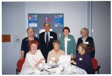 Musculoskeletal Health Australia (now held by the Glen Eira Historical Society)
Photograph - Group photo, 2001
... The program was broadcast on Community Television station, Channel 31. In this photo, members of the Joint Action Group (holding up their certificates of appreciation) pose for a photo with AFV President, Bruce Dyson....The program was broadcast on Community Television station, Channel 31. In this photo, members of the Joint Action Group (holding up their certificates of appreciation) pose for a photo with AFV President, Bruce Dyson. arthritis foundation of victoria afv move it or lose it television program television series broadcast television community television channel 31 audiovisual morning tea bruce dyson president joint action group jag 2001 [On a yellow sticky note, in blue ink] Joint Action Group Bruce Dyson ['Bruce' initially spelt with an 's', and then overwritten with a 'c'] COL photo of seven people, (three seated at a table and four standing behind them), posing for a photo. ...In 2001, the Arthritis Foundation of Victoria held a morning tea to thank the members and professionals who had participated in its innovative television exercise program, "Move It of Lose It". The program was broadcast on Community Television station, Channel 31. In this photo, members of the Joint Action Group (holding up their certificates of appreciation) pose for a photo with AFV President, Bruce Dyson.COL photo of seven people, (three seated at a table and four standing behind them), posing for a photo. Two women, seated, hold a certificate up towards the camera. On the table, there are cups and saucers, cake plates, and a large stainless steel platter with a paper doily on top. In the background, there is a large display board with two "Move It or Lose It" posters and various other items pinned to the board.[On a yellow sticky note, in blue ink] Joint Action Group Bruce Dyson ['Bruce' initially spelt with an 's', and then overwritten with a 'c']arthritis foundation of victoria, afv, move it or lose it, television program, television series, broadcast television, community television, channel 31, audiovisual, morning tea, bruce dyson, president, joint action group, jag, 2001 -
 Vision Australia
Equipment - Object, Stainsby braille writer, 1930-1940's
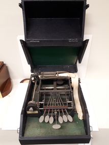
... A roll of thin white paper is mounted on an attachment to the side of the machine, and the paper is threaded along a channel at the top of the machine and comes out the other side in a continuous roll. ...A roll of thin white paper is mounted on an attachment to the side of the machine, and the paper is threaded along a channel at the top of the machine and comes out the other side in a continuous roll. ...Henry Stainsby (1859-1925), Supt. of the Birmingham Royal Institution for the Blind, (later General Secretary of the British & Foreign Blind Association) along with Birmingham manufacturer Albert Wayne, introduced their Shorthand Braille Writer, circa 1910-1940. Used at the Royal Victorian Institute for the Blind. These machines were often supplied with a case, to deaden the sound when in use. The machine was designed to take down verbatim reports from dictation. As the strip of paper passes automatically through the machine, no time is needed to adjust the paper or the machine for each line. Speeds of 80 - 140 words per minute can be obtained.Contained in a dark blue case which folds down to reveal the keys, this portable Braille writer has six flat keys in front and a space key, attached to a marking device at the back. A roll of thin white paper is mounted on an attachment to the side of the machine, and the paper is threaded along a channel at the top of the machine and comes out the other side in a continuous roll. A red round rubber guard is just behind the keys. Royal National Institute for the Blind label attached.braille equipment, royal victorian institute for the blind -
 Melbourne Tram Museum
Functional object - Timetable Board, Melbourne & Metropolitan Tramways Board (MMTB), Camberwell Junction - Batman Ave, 1970s
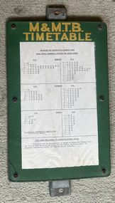
... Board made up to display tramway timetables for attachment to a post comprising heavy galvanised steel backing sheet with two small channels either end, spot welded to the steel back, front painted in green with the letters "M&M.T.B" in yellow paint, perspex sheet at the front, secured by 6 Allen screws with nuts on rear, containing a typed timetable sheet - for Camberwell Junction for Batman Ave timetable - undated....Demonstrates a timetable board style used by the MMTB in the 1970s and early 1980s. tramways Map Batman Ave Camberwell Junction Route 70 timetable Board made up to display tramway timetables for attachment to a post comprising heavy galvanised steel backing sheet with two small channels either end, spot welded to the steel back, front painted in green with the letters "M&M.T.B" in yellow paint, perspex sheet at the front, secured by 6 Allen screws with nuts on rear, containing a typed timetable sheet - for Camberwell Junction for Batman Ave timetable - undated. ...Timetable board for Camberwell Junction Batman Ave route 70, detailing times that services were scheduled to depart the Junction. Probably used until replaced by The Met style signs in the mid-1980s.Demonstrates a timetable board style used by the MMTB in the 1970s and early 1980s.Board made up to display tramway timetables for attachment to a post comprising heavy galvanised steel backing sheet with two small channels either end, spot welded to the steel back, front painted in green with the letters "M&M.T.B" in yellow paint, perspex sheet at the front, secured by 6 Allen screws with nuts on rear, containing a typed timetable sheet - for Camberwell Junction for Batman Ave timetable - undated. tramways, map, batman ave, camberwell junction, route 70, timetable -
 Melbourne Legacy
Document, Publicity
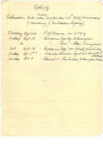
... Anonymous notes listing 1959 reviews in The Age, and the Sun, and interviews on Channels 2 and 9. There is no indication of whether these actually eventuated. 00931.2 covers selected extracts in The Age, Country Life, Sydney Morning Herald, and Courier, Ballarat, none of which are exactly fulsome. 00931.3 is a review by someone using the pseudonym "Ache-Day", which is complimentary and typical of the writing style of the times....Melbourne Legacy 293 Swanston Street Melbourne melbourne Anonymous notes listing 1959 reviews in The Age, and the Sun, and interviews on Channels 2 and 9. There is no indication of whether these actually eventuated. 00931.2 covers selected extracts in The Age, Country Life, Sydney Morning Herald, and Courier, Ballarat, none of which are exactly fulsome. 00931.3 is a review by someone using the pseudonym "Ache-Day", which is complimentary and typical of the writing style of the times. ...Anonymous notes listing 1959 reviews in The Age, and the Sun, and interviews on Channels 2 and 9. There is no indication of whether these actually eventuated. 00931.2 covers selected extracts in The Age, Country Life, Sydney Morning Herald, and Courier, Ballarat, none of which are exactly fulsome. 00931.3 is a review by someone using the pseudonym "Ache-Day", which is complimentary and typical of the writing style of the times.Part of the story of how the book 'There goes a Man' came to be created.Handwritten and/or typed notes on publicity and reviews of the Savige biography in 1959. 00931 written in black ink on lined paper torn from a notebook, 00931(2) and 00931(3) black type on fading white paper. savige book, biography -
 Tarnagulla History Archive
Photograph: Planting ceremony to commence Pine Plantation, Tarnagulla, June 1925
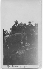
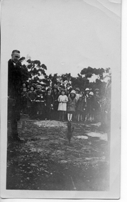
... From tarnagulla.org by David Gordon: "The plantation is bounded by King, Gladstone and Welsh Streets and on the east by the drainage channel. It was planted up and opened in June 1925. ...Tarnagulla History Archive Tarnagulla Public Hall 69-71 Commercial Rd Tarnagulla goldfields From tarnagulla.org by David Gordon: "The plantation is bounded by King, Gladstone and Welsh Streets and on the east by the drainage channel. It was planted up and opened in June 1925. ...From tarnagulla.org by David Gordon: "The plantation is bounded by King, Gladstone and Welsh Streets and on the east by the drainage channel. It was planted up and opened in June 1925. It is located on the massive sand heap of R.W.Hammond's quartz crushing battery, and the plantation served to enhance the appearance of a large-scale mining precinct which was by 1925 seen as an eyesore from the bygone mining days". Donald Clark Collection. A monochrome photograph of a group of men in suits and hats planting seedlings as part of a planting ceremony to commence the Pine Plantation, Tarnagulla.tarnagulla, trees, mining, pine plantation, the pines, landmarks, children -
 Tarnagulla History Archive
Photograph: Children at planting ceremony to commence Pine Plantation, Tarnagulla, June 1925
... From tarnagulla.org by David Gordon: "The plantation is bounded by King, Gladstone and Welsh Streets and on the east by the drainage channel. It was planted up and opened in June 1925. ...Tarnagulla History Archive Tarnagulla Public Hall 69-71 Commercial Rd Tarnagulla goldfields From tarnagulla.org by David Gordon: "The plantation is bounded by King, Gladstone and Welsh Streets and on the east by the drainage channel. It was planted up and opened in June 1925. ...From tarnagulla.org by David Gordon: "The plantation is bounded by King, Gladstone and Welsh Streets and on the east by the drainage channel. It was planted up and opened in June 1925. It is located on the massive sand heap of R.W.Hammond's quartz crushing battery, and the plantation served to enhance the appearance of a large-scale mining precinct which was by 1925 seen as an eyesore from the bygone mining days". Donald Clark Collection. A monochrome photograph of a group of children observing a ceremony to commence the Pine Plantation, Tarnagulla.tarnagulla, trees, mining, pine plantation, the pines, landmarks, children -
 Tarnagulla History Archive
Photograph: Planting ceremony to commence Pine Plantation, Tarnagulla, June 1925
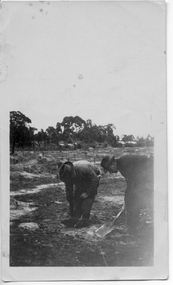
... From tarnagulla.org by David Gordon: "The plantation is bounded by King, Gladstone and Welsh Streets and on the east by the drainage channel. It was planted up and opened in June 1925. ...Tarnagulla History Archive Tarnagulla Public Hall 69-71 Commercial Rd Tarnagulla goldfields From tarnagulla.org by David Gordon: "The plantation is bounded by King, Gladstone and Welsh Streets and on the east by the drainage channel. It was planted up and opened in June 1925. ...From tarnagulla.org by David Gordon: "The plantation is bounded by King, Gladstone and Welsh Streets and on the east by the drainage channel. It was planted up and opened in June 1925. It is located on the massive sand heap of R.W.Hammond's quartz crushing battery, and the plantation served to enhance the appearance of a large-scale mining precinct which was by 1925 seen as an eyesore from the bygone mining days". Donald Clark Collection. A monochrome photograph of two men planting seedlings during a ceremony to commence the Pine Plantation, Tarnagulla.tarnagulla, trees, mining, pine plantation, the pines, landmarks -
 Tarnagulla History Archive
Photograph: Planting ceremony to commence Pine Plantation, Tarnagulla, June 1925
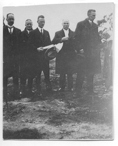
... From tarnagulla.org by David Gordon: "The plantation is bounded by King, Gladstone and Welsh Streets and on the east by the drainage channel. It was planted up and opened in June 1925. ...Tarnagulla History Archive Tarnagulla Public Hall 69-71 Commercial Rd Tarnagulla goldfields From tarnagulla.org by David Gordon: "The plantation is bounded by King, Gladstone and Welsh Streets and on the east by the drainage channel. It was planted up and opened in June 1925. ...From tarnagulla.org by David Gordon: "The plantation is bounded by King, Gladstone and Welsh Streets and on the east by the drainage channel. It was planted up and opened in June 1925. It is located on the massive sand heap of R.W.Hammond's quartz crushing battery, and the plantation served to enhance the appearance of a large-scale mining precinct which was by 1925 seen as an eyesore from the bygone mining days". Donald Clark Collection. A monochrome photograph of a group of men during a ceremony to commence the Pine Plantation, Tarnagulla. Handwritten inscription on reverse names subjects as (L-R) 'Dad (Foth) on left hand side' and 'Mr [Owen] Jones, Chairman of Forest Commission Vict., Mr Johns District Schools Inspector, Mr McRae Chief Inspector of Forestry of Education Department'.tarnagulla, trees, mining, pine plantation, the pines, landmarks, forestry commission, owen jones, fotheringham -
 Musculoskeletal Health Australia (now held by the Glen Eira Historical Society)
Photograph - Group photo, 2001
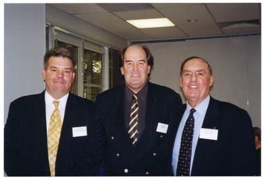
... The program was broadcast on Community Television station, Channel 31. In this photo, AFV President, Bruce Dyson, and Peter Johnson from Renaissance Television present Lesleigh with a certificate of appreciation and a video cassette of the program....The program was broadcast on Community Television station, Channel 31. In this photo, AFV President, Bruce Dyson, and Peter Johnson from Renaissance Television present Lesleigh with a certificate of appreciation and a video cassette of the program. arthritis foundation of victoria afv move it or lose it television program television series broadcast television community television channel 31 audiovisual morning tea peter johnson renaissance television bruce dyson president lesleigh 2001 [On a yellow sticky note, in blue ink] Peter Johnson Lesleigh COL photo of two men standing near a woman who is seated at a table with several others. ...In 2001, the Arthritis Foundation of Victoria held a morning tea to thank the members and professionals who had participated in its innovative television exercise program, "Move It of Lose It". The program was broadcast on Community Television station, Channel 31. In this photo, AFV President, Bruce Dyson, and Peter Johnson from Renaissance Television present Lesleigh with a certificate of appreciation and a video cassette of the program.COL photo of two men standing near a woman who is seated at a table with several others. One of the men is looking down at a piece of paper, which he is holding in his hand. The woman also has a piece of paper in her hand. The other man is holding a video cassette in his hand. They are all smiling. In the background, there are some people seated at another table.[On a yellow sticky note, in blue ink] Peter Johnson Lesleigharthritis foundation of victoria, afv, move it or lose it, television program, television series, broadcast television, community television, channel 31, audiovisual, morning tea, peter johnson, renaissance television, bruce dyson, president, lesleigh, 2001 -
 Musculoskeletal Health Australia (now held by the Glen Eira Historical Society)
Photograph - Group photo, 2001
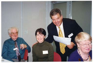
... The program was broadcast on Community Television station, Channel 31. In this photo, Peter Johnson (Renaissance Television), Doug Wade (Presenter), and Bruce Dyson (AFV President) pose for a photo at the morning tea event....The program was broadcast on Community Television station, Channel 31. In this photo, Peter Johnson (Renaissance Television), Doug Wade (Presenter), and Bruce Dyson (AFV President) pose for a photo at the morning tea event. arthritis foundation of victoria afv move it or lose it television program television series broadcast television community television channel 31 audiovisual morning tea peter johnson renaissance television doug wade presenter bruce dyson president 2001 [On a yellow sticky note, in blue ink] Peter [lesliegh (crossed out)] Johnson. ...In 2001, the Arthritis Foundation of Victoria held a morning tea to thank the members and professionals who had participated in its innovative television exercise program, "Move It of Lose It". The program was broadcast on Community Television station, Channel 31. In this photo, Peter Johnson (Renaissance Television), Doug Wade (Presenter), and Bruce Dyson (AFV President) pose for a photo at the morning tea event.COL photo of three men posing for a photo. They are in a large room. In the background, there is a set of windows with thin venetian blinds to the left. There is a view of some trees through the windows.[On a yellow sticky note, in blue ink] Peter [lesliegh (crossed out)] Johnson. Doug [illegible (crossed out)] Wade Bruce Dyson [On another yellow sticky note, in back ink] Move it or Lose it TV show - morning tea.arthritis foundation of victoria, afv, move it or lose it, television program, television series, broadcast television, community television, channel 31, audiovisual, morning tea, peter johnson, renaissance television, doug wade, presenter, bruce dyson, president, 2001 -
 Kiewa Valley Historical Society
Stocks for Riding Boots, Late 1800's to early 1900's
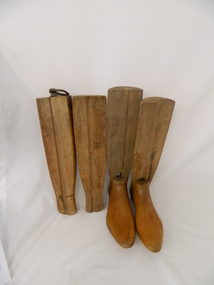
... Each of the four boot tree parts fit snugly together and maintain their form, and that of the boot that they occupy. The groove channels and foot forms (tongue and groove) are exact and once snapped together become very solid. ...Each of the four boot tree parts fit snugly together and maintain their form, and that of the boot that they occupy. The groove channels and foot forms (tongue and groove) are exact and once snapped together become very solid. ...These wooden trees for riding stocks are a concept that was brought to early colonial days from "mother" England. Gentle folk of wealth and status used these trees from early 1800's to keep and maintain their riding boots in their correct form. This form of maintaining the tall riding boot structure was maintained in Australia by the rural "elite" both on cattle properties and smaller cattle stations in the early 1900's. Good riding boots were a status symbol in rural and outback Australia. The riding stocks "wooden trees" are very significant in the Kiewa Valley because they were used by members of some of the original grazing cattle families to settle there. Both cattle and sheep properties occupied large areas of the Kiewa Valley and they also herded their flock and herd on the Bogong High Plains region. These stocks and boots were worn by Fred Roper whose great grand daughter donated them to KVHS. Therefore these boots and stocks would date from 1880's to 1920's and are a good representation of the style of boots worn during this period. This pair of wooden stocks for riding boots trees has been manufactured to a very high standard. Each of the four boot tree parts fit snugly together and maintain their form, and that of the boot that they occupy. The groove channels and foot forms (tongue and groove) are exact and once snapped together become very solid. There is a brass ring, attached by a small brass "peg" on each of the thin "sliding" middle uprights. See KVHS 0177 - Riding boots.On top "L" (for left boot), "R" (for right boot)horse. country. leather. gaiters. high plains. grazing. cattlemen. laces. studs. stocks. roper family. bogong high plains. -
 Bendigo Historical Society Inc.
Document - ELECTRIC TELEGRAPH 1985 FROM R. BROUGH SMYTH (SECRETARY FOR MINES) TO G. A. FLETCHER TOWN CLERK, BENDIGO
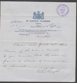
... Fletcher Town Clerk, Bendigo Telegraph details: A message dated Melbourne 26th September 1985 -- Please read first and thiord clauses of the order in Council - Do you consider that the order was framed to admit of mining under the channel B message dated Melbourne 27th September 1985 - in my opinion to undermine would be a violation of the first condition...Fletcher Town Clerk, Bendigo Telegraph details: A message dated Melbourne 26th September 1985 -- Please read first and thiord clauses of the order in Council - Do you consider that the order was framed to admit of mining under the channel B message dated Melbourne 27th September 1985 - in my opinion to undermine would be a violation of the first condition Document ELECTRIC TELEGRAPH 1985 FROM R. ...Electric Telegraph 1985 from R. Brough Smyth (Secretary for Mines) to G. A. Fletcher Town Clerk, Bendigo Telegraph details: A message dated Melbourne 26th September 1985 -- Please read first and thiord clauses of the order in Council - Do you consider that the order was framed to admit of mining under the channel B message dated Melbourne 27th September 1985 - in my opinion to undermine would be a violation of the first condition -
 Federation University Historical Collection
Photograph - Photorgraphs - Black and White, Aerial Photographs around the Ballarat School of Mines, Pre 1967
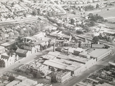
... Shows Ballarat School of Mines, Ballarat Gaol, Ballarat Girls' Technical School, gasometers, White Flat, Yarrowee Channel. 8251.3 & .4 & .5 - Black and white photograph taken from an aeroplane over Ballarat. ...Shows Ballarat School of Mines, Ballarat Gaol, Ballarat Girls' Technical School, gasometers, White Flat, Yarrowee Channel. 8251.3 & .4 & .5 - Black and white photograph taken from an aeroplane over Ballarat. ...Ballarat School of Mines is in Lydiard Street South, in close proximity to White Flat oval. 3821.1 & .2 - Black and white photograph taken from an aeroplane over Ballarat. Shows Ballarat School of Mines, Ballarat Gaol, Ballarat Girls' Technical School, gasometers, White Flat, Yarrowee Channel. 8251.3 & .4 & .5 - Black and white photograph taken from an aeroplane over Ballarat. Shows Ballarat School of Mines, Ballarat Gaol, Ballarat Junior Technical School, Albert Street, Gaol garden, Manchester Unity Hall ballarat school of mines, aerial photograph, hickman street, white flat oval, former ballarat gaol, ballarat girls' technical school, gasometer, aeroplane, white flat, armstrong street south, ballarat gaol, manchester university hall -
 Musculoskeletal Health Australia (now held by the Glen Eira Historical Society)
Photograph - Group photo, 2001
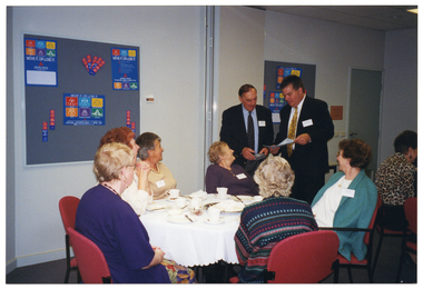
... The program was broadcast on Community Television station, Channel 31. In this photo, AFV President, Bruce Dyson, and Peter Johnson from Renaissance Television present members of the Joint Action Group with certificates of appreciation and a video cassette of the program....The program was broadcast on Community Television station, Channel 31. In this photo, AFV President, Bruce Dyson, and Peter Johnson from Renaissance Television present members of the Joint Action Group with certificates of appreciation and a video cassette of the program. arthritis foundation of victoria afv move it or lose it television program television series broadcast television community television channel 31 audiovisual morning tea bruce dyson president peter johnson renaissance television joint action group jag 2001 [On a yellow sticky note, in blue ink] Peter Johnson & Bruce Dyson & Joint Action COL photo of two men standing next to a table, at which several women are seated. ...In 2001, the Arthritis Foundation of Victoria held a morning tea to thank the members and professionals who had participated in its innovative television exercise program, "Move It of Lose It". The program was broadcast on Community Television station, Channel 31. In this photo, AFV President, Bruce Dyson, and Peter Johnson from Renaissance Television present members of the Joint Action Group with certificates of appreciation and a video cassette of the program.COL photo of two men standing next to a table, at which several women are seated. One man is holding some sheets of paper, while the other man is holding a video cassette. One of the men is speaking, while the other man is looking down. The women are looking at the men. On the table, there are cups and saucers, cake plates and a large platter.[On a yellow sticky note, in blue ink] Peter Johnson & Bruce Dyson & Joint Actionarthritis foundation of victoria, afv, move it or lose it, television program, television series, broadcast television, community television, channel 31, audiovisual, morning tea, bruce dyson, president, peter johnson, renaissance television, joint action group, jag, 2001 -
 Musculoskeletal Health Australia (now held by the Glen Eira Historical Society)
Photograph - Group photo, 2001
... The program was broadcast on Community Television station, Channel 31. In this photo, Peter Johnson from Renaissance Television presents Mary Granthan with a certificate of appreciation. ...The program was broadcast on Community Television station, Channel 31. In this photo, Peter Johnson from Renaissance Television presents Mary Granthan with a certificate of appreciation. ...In 2001, the Arthritis Foundation of Victoria held a morning tea to thank the members and professionals who had participated in its innovative television exercise program, "Move It of Lose It". The program was broadcast on Community Television station, Channel 31. In this photo, Peter Johnson from Renaissance Television presents Mary Granthan with a certificate of appreciation. Seated beside Mary are Bill O'Connor (left) and an unidentified woman (right).COL photo of a man, standing, as he leans forward towards three people who are seated at a table. He has one hand placed on the shoulder of the woman in the middle. They are both smiling broadly.[On a yellow sticky note, in blue ink] Peter [lesliegh (crossed out)] Johnson Mary Granthan Bill O'Connorarthritis foundation of victoria, afv, move it or lose it, television program, television series, broadcast television, community television, channel 31, audiovisual, morning tea, peter johnson, renaissance television, mary granthan, bill o’connor, 2001