Showing 1550 items
matching site plans
-
 Greensborough Historical Society
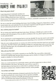
Document - Leaflet, Introducing the Monty Hub Project, 2021 c
Proposal to develop the site with existing buildings at 1-3 Mountain View Road Montmorency as a community hub. The buildings are a former church and kindergarten designed by Alistair Knox. 2 p., printed in black both sides on off white paper, plan, photographmontmorency hub, monty hub project -
 Mortlake and District Historical Society
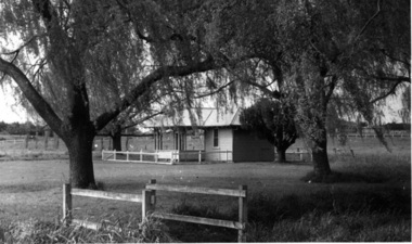
Photograph - Montgomery Pavillion, Montgomery Pagoda or Pavillion, 1924
In July 1922 Rev. W. McBride of the St Andrews Presbyterian Church, Mortlake had a meeting with the Garden sub-committee to discuss how the 500 pounds sterling bequest from the Late Thomas Montgomery could best be spent. His suggestion was that the money should be spent on either a kiosk, pavillion or recreation hall and pavillion combines with kitchen and fireplace was agreed to with exact site to decided at a public meeting. Cr Montgomery, a local businessman and a councillor, had loved the gardens and had assisted to transform the area from a swamp into a thing of beauty. The design was chosed by his widow who had seen a smilar design in King's Park whilst in Perth so the plans were obtained from that City. The work was carried out by Archibald Cluny McDonald and completed in September 1924. In December 1924 the Montgomery Pagado was unveiled to the public by Cr Wells Brumley after which the Red Cross ladies served tea.THIS TABLET IS DESIGNED TO COMMEMORATE THE GENEROSITY OF THE LATE COUNCILLOR THOMAS MONTGOMERY BY WHOM THIS PAVILLION WAS GRACIOUSLY BEQUEATHED TO THE TOWN OF MORTLAKE AND TO PERPETUATE THE MEMORY OF HIS NOBILITY OF CHARACTER AND EXTREME WORTH AS A CITIZENpagoda -
 Mission to Seafarers Victoria
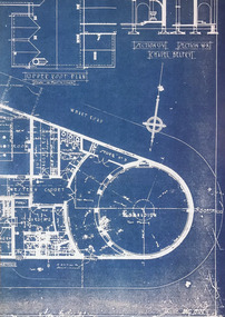
Poster, Ying-Lan Dann, Circular Temporalities, July 2022
Take Hold of the Clouds is a curated exhibition featuring two key works by renowned international contributors – Forensic Architecture’s Cloud Studies (2021) and Cauleen Smith’s Sojourner (2018) – along with six, newly commissioned, responsive works from local and national creative practitioners. The experimental exhibition is distributed across seven of the city’s most significant buildings and urban spaces, with each temporal creative work adding a new layer to how we understand these spaces in relation to the world around us. Embedding the work within the city itself rather than a traditional gallery, the exhibition models best practices for high-impact yet sustainable and resource-sensitive exhibition-making. Created in partnership with Monash University, Take Hold of the Clouds navigates the Weekend’s theme of Built/Unbuilt through a series of thoughtful encounters in which artists reveal the invisible stories and issues in corners of the city. The exhibition is conceived by Tara McDowell, Director of Curatorial Practice at Monash Art, Design and Architecture, and co-curated with Fleur Watson, Open House Melbourne’s Executive Director. To create this poster, the artist used a copy of of one of Walter Butler plans for the 7171 building held in the archives as an homage to the architect. The sketch was then retouched to make it loo like a blueprint. The Mission is one of the sites open every year during Open House. A3 size Blue print type plan print on glose paper.open house melbourne, 2022, ying-lan dann, circular temporalities, norla dome, blueprint, plans, walter richmond butler (1864–1949), cultural events -
 Mission to Seafarers Victoria
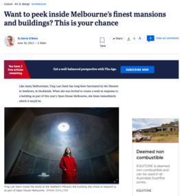
Article, Kerrie O'Brien, Want to peek inside Melbourne’s finest mansions and buildings? This is your chance, 30 June 2022
... . Dann also plans to activate the site over the course.... Dann also plans to activate the site over the course ...Open House 2022: "Like many Melburnians, Ying-Lan Dann has long been fascinated by the Mission to Seafarers, in Docklands. When she was invited to create a work in response to a building as part of this year’s Open House Melbourne, she knew immediately which it would be. Taking a peek behind the closed doors of some of Melbourne’s finest and most interesting buildings is a core premise of the weekend event, now in its 15th year. During that time, the program has grown from half a dozen buildings to a 200-plus strong list that extends to Ballarat and Bendigo. “[It’s] much more expansive and citizen-led,” says Fleur Watson, Open House Melbourne’s executive director. “As a public festival, it has always had a spirit of generosity, this gesture of opening up and allowing visitors to come and look and experience things.” Swinging open their doors at the end of the month will be some of the city’s finest mansions, including Villa Alba in Kew and Brighton’s Billilla, the Cairo flats in Fitzroy, the newly renovated Jewish Museum designed by Kerstin Thompson, the Melbourne Quakers Centre, the Albanian Mosque in Carlton North and many more. Considering how to approach the event this year, held remotely for the past two, Watson decided to explore beyond the traditional, with associate professor and director of curatorial practice at Monash University Tara McDowell. The two have co-curated an exhibition of works to run concurrently with the Open House program, called Take Hold of the Clouds. That’s where Dann’s work, Circular Temporalities, comes in, one of seven commissions around town in which local and international artists respond to chosen buildings or sites. A lecturer in interior design at RMIT as well as an artist, she is interested in time and finding different mediums to show things in flux and, having grown up on Phillip Island, she often uses water as a theme. When she started spending time at the Mission, Dann found there was an oculus at the top of the dome, known as the Norla Dome. She thought about how that small but significant opening related to where sailors spent so many months of the year, the sky being the only thing they would see much of the time, stars guiding the way in times gone by, and of the recent stories she’d heard about sailors being trapped at sea during COVID. Built in the Arts and Craft style between 1916 and 1919 and designed by architect Walter Butler, the Mission includes a chapel, clubroom, Chaplain’s house, a small cottage and the Norla Dome, which was apparently inspired by the Pantheon. The Mission was funded by the government and the Ladies Harbour Lights Guild, who Dann was also intrigued by. “One of the things those women identified is that life at sea is very dangerous [and they] wanted to give them a space of sanctuary and support,” she says, adding that for many years, the dome was used as a gymnasium. Her work inside the dome includes a 35-minute loop film, recorded from the ferry during the crossing from Queenscliff to Sorrento. The horizon takes up about a third of the shot and moves as the waves rise and fall, mirroring the journeys made by the sailors who found refuge at the mission over the years; it will be projected onto a gauze-like fabric, allowing glimpses of the building behind. Dann also plans to activate the site over the course of the weekend and will read a poem by Justin Clemens.The articles gives an insight of the création of the artwork by Ying-Lan Dann. digital copy of an article with photographs published in the Ageopen house melbourne, 2022, ying-lan dann, take hold of the clouds, norla dome, exhibition, the age, cultural events -
 Greensborough Historical Society
Map, Melbourne and Metropolitan Board of Works. Survey Division, MMBW, Yarra 2500 / 12.20. Watsonia Railway Station and environs, 1983_03
Melbourne and Metropolitan Board of Works. Yarra 2500 [base map]. 12-20, Parishes of Keelbundora 2856, Municipalities of Diamond Valley 257 and 228. Shows street names, easement sizes, lot numbers, lodged plan numbers, names of prominent features, contour values, creek or river names. Watsonia Railway Station and environs. Prominent streets: Watsonia Road, Elder Street, Morwell Avenue and Nepean Street. Includes former Watsonia Technical School and Gresswell Rehabilitation Centre sites.MMBW Map in 1:2500 [scale] series. Cream parchment with green tape reinforcing on edges and punched holes on left edge.mmbw, melbourne and metropolitan board of works, shire of diamond valley, watsonia - maps -
 Greensborough Historical Society
Map, Melbourne and Metropolitan Board of Works. Survey Division, MMBW, Yarra 2500 / 12.22. Watsonia North, 1978_03
Melbourne and Metropolitan Board of Works. Yarra 2500 [base map]. 12-22, Parishes of Keelbundora 2856, Municipalities of Whittlesea 239 and Diamond Valley 257. Shows street names, easement sizes, lot numbers, lodged plan numbers, names of prominent features, contour values, creek or river names. Watsonia Railway Station and environs. Prominent streets: Edmund Rice Parade and Macorna Street. Includes Christian Brothers Edmund Rice College and Janefield Special School sites and "proposed future freeway" (now Metropolitan Ring Road).MMBW Map in 1:2500 [scale] series. Cream parchment with green tape reinforcing on edges and punched holes on left edge.mmbw, melbourne and metropolitan board of works, shire of diamond valley, watsonia - maps, bundoora - maps -
![Document collection, Watsonia development [Lambourn and Devonshire Roads], 2019_](/media/collectors/4f729f5697f83e03086015b8/items/5d82cea121ea6712b80a7cdd/item-media/5d8579dd21ea67168c696120/item-fit-380x285.jpg) Greensborough Historical Society
Greensborough Historical SocietyDocument collection, Watsonia development [Lambourn and Devonshire Roads], 2019_
In 2003, a proposal for a 5 storey building on the corner of Lambourn and Devonshire Roads Watsonia for an apartment complex, medical centre, shops and cafe was approved by VCAT, despite strong opposition by local residents. The proposal did not proceed. In 2019 a proposal for a 2 storey medical centre, cafe and residence was approved for the site and construction commenced. Collection of documents comprising history of development proposals by Rosie Bray, concept illustrations, archtect's plans, photograph and copy of newspaper clipping.watsonia, lambourn road watsonia, devonshire road watsonia -
![Advertising Leaflet, Grace Park Electric Station Estate, Watsonia [2], 21/06/1924](/media/collectors/4f729f5697f83e03086015b8/items/5dcfb86d21ea671434eca90c/item-media/5dcfb88e21ea671434ecd037/item-fit-380x285.jpg) Greensborough Historical Society
Greensborough Historical SocietyAdvertising Leaflet, Grace Park Electric Station Estate, Watsonia [2], 21/06/1924
Digital copy of auction leaflet for sale of land known as Grace Park Electric Station Estate, Saturday 21/06/1924. Auctioneer Knight & Harwood in conjunction with C. Jessop. This leaflet features block plans and a railway line illustration showing the site of 'Grace Park Railway Station'.Digital copy of auction leaflet 1 page. Black and red text on white paper.watsonia, grace park -
 Greensborough Historical Society
Map, Saxam Heritage Overlay, 2011_
"Saxam" was the home of the Kaye family (1886-1888) then William Santon, a former councillor and Mayor of Heidelberg. Saxam Homestead is a distinctive and substantial timber homestead built in the late 1880s as one of the notable rural properties in the St Helena area. In 2014 the house still stands but is in poor condition with most interior features removed. The site had a heritage overlay as shown. The overlay was reduced in 2014 to protect the house while allowing residential development on the site.Saxam is one of the only remaining farmhouses in the Greensborough area.Copy of map and planning scheme.saxam -
 Greensborough Historical Society
Newspaper Clipping, Diamond Valley News, Outbid college blasts Loyola sale, and, Panel backs shire on Loyola, 07/09/1994
These articles detail the changes to planning regulations around the Loyola seminary site and its sale by the state government to the Maharishi organisation in 1994.These articles show the community interest in the Loyola site and its buildings and form part of the ongoing history of this site.2 newspaper articles. Text only.loyola college, loyola seminary watsonia, ignatian, maharishi -
 Greensborough Historical Society
Document, Amendment C78 to the Nillumbik Planning Scheme, 03/09/2012
The planning scheme amendment is to extend protection to a group of Pioneer Children's graves and an historic apple tree.The graves are from the pioneering Whatmough and Partington families. The apple tree is the surviving remnant of a former orchard on the site and is believed to have been purchased from the estate of John Batman.A 16 page collection of documents sent to GHS Committee member Anne Paul regarding an amendment to the Nillumbik Planning Scheme.Niljohn batman, batman apple tree, whatmough, partington, plenty river, pioneer childrens graves, plenty river trail, nillumbik shire council, greensborough, c78 -
 Greensborough Historical Society
Photograph - Digital Image, Art at WaterMarc, July 2017, 22/07/2017
Photographs of an art installation by Jessie Stanley at WaterMarc Greensborough on 22/07/2017. From Jessie Stanley's FaceBook page :Dust to Dust is complete... It's an ephemeral site-specific work about how the Melbourne suburb of Greensborough has transformed over time. This area's exceptionally fertile soil [used by] by white settlers for farms, market gardens and orchards reshaped the Wurundjeri's traditional lands - and today the private sale and division of these farms informs the streetscape and town plan. With soil sourced locally this work reveals some of the area’s history - the text running around the perimeter was written by former resident Val Wilson, a snippet of her recollections of growing up in the area in the 1950s. The arrows and text act like a compass to orientate this site with greater Melbourne. On display in the lobby of Banyule Council until chance, time (or a broom) sweeps it away, Many thanks to Banyule City Council, Greensborough Historical Society and Valerie Wilson. "An artistic representation of Greensborough's history.Digital photographs of art installation.jessie stanley, watermarc, greensborough historical society, banyule council -
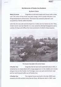 Greensborough Historical Society
Article, Norm Colvin, My memories of Poulter Ave residents, by Norm Colvin, 28/07/2016
Details of the development and occupation of sites in Poulter Avenue and Bicton Street Greensborough, compiled by resident Norm Colvin.12 pages, text, black and white photographs and colour subdivision plan.poulter avenue greensborough, bicton street greensborough -
 Greensborough Historical Society
Document, Victoria. Department of Environment Land Water and Planning, Proposed planning changes for Austin Hospital, 28/10/2016
Information on proposed changes to heritage overlays on the Austin Hospital site on Studley Road Heidelberg4p. coloured information sheet, with one page covering letter from the Government Land Standing Advisory Committeeaustin hospital -
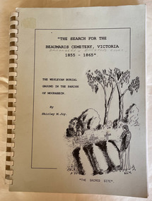 City of Moorabbin Historical Society (Operating the Box Cottage Museum)
Book - Family History, Joy, Shirley, The Search For The Beaumaris Cemetery Victoria 1855--1865 : The Wesleyan burial ground in the Parish of Moorabbin, 1995
A history of the Beaumaris Cemetery and who is buried there and the subdivision of the Wesleyan church.vii, 92 leaves : ill., facsims., 1 plan, ports. A large spiral bound book with a soft cover detailing the early burial sites in the Beaumaris Cemetery.The front cover is white with a drawn picture of three graves and a girl in a long dress standing beside them also on the cover is the The Wesleyan Burial Ground in the Parish of Moorabbin.non-fictionA history of the Beaumaris Cemetery and who is buried there and the subdivision of the Wesleyan church.beaumaris, cheltenham, graves, burials, cemetery, registrar's records, subdivision, wesleyan. -
 Halls Gap & Grampians Historical Society
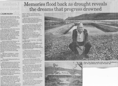
Newspaper - B/W
Until the closure 40 years ago, the Myrtlebank Guesthouse near Halls Gap in the Grampians was a thriving family - run business. In 1962, all that changed when the government of the day purchased the land on which the guesthouse stood and some neighbouring farms and houses. For almost 40 Years, the remains of the buildings have been submered under the man made reservoir known as Lake Bellfield. Due to drought, the eater levels have dropped steadily and, in the past month, the memories underneath Lake Bellfield have come to the surface. Local resident Don warren 70, has been to have a look. His grandmother Anne Flower Warren, was 56 when she opened the guesthouse in 1916. Widowed, the year before after a horse kicked her farmer husband, Mrs Flower needed to provide for their large family. "She had 13 children - seven daughters. I think she built it to look after the girls," Mr Warren says, "The whole think was built on a 500 acre farm." With the guesthouse sited in the centre of the farm, the land was divided between two of her sons- Mr Warren's uncle working one side and his father taking the other. For Mr Warren, the grounds of the two-storey guesthouse were an extension of a huge rural playground in what he remembers as an idyllic childhood. "I used to get taken over there and I'd sit there and watch her make all the toast for the guests. It was quite full all the time - maybe 40 or 50 people. It was a great big place - very grand. In the bedrooms I can remember the great big bowls full of water to wash your face in. There was a big dining room, too. My grandmother was a great cook." By the time of Mrs Warren's death in 1936, her eldest daughter also Anne, had officially taken over the running of the business. "It was in the family right until the last bit. The youngest daughter, Auntie Hilda, took it over right at the end. they got a notice to say that's it - it's over There was no way out of that one." Mrs Ida Stanton, 78, is the historian for the Halls Gap and Grampians Historical Society. Can she remember it when it all happened? "Of course" she says "It's only 40 years ago" Her memories of Myrtlebank are of a place popular with honeymooners, who would often return year after year, bringing their families with them. "There was a lovely ballroom where they used to invite the Gap people and the tourists in to have balls. During the war it was one means of making money to send stuff over to the soldiers." Seeing just the stumps of the guesthouse and what had been his family home, Mr Warren says the bitterness is still there. "The hardest part was poor old dad. He was 70 years old when he got turfed out. Dad had been a farmer all his life - 214 acres, he had, and he got 22,000 quid. Had to move into town" Also showing beneath the drying lake is the concrete slab of the new home Mr Warren planned after his marriage to wife Anne in 1955. Another lost dream. " I was the only child, I was going to take over the farm, but that all changed. You can't take it over when it's full of water.Newspaper clipping of history of Myrtlebank by Don Warren and photo of Don at old site of pooland guest House photo Article by Claire Halliday from newspaper 2002accommodation, guesthouses, myrtlebank -
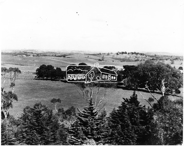
 Eltham District Historical Society Inc
Photograph, Shire of Eltham War Memorial, Memorial Park, Garden Hill, Kangaroo Ground; Eltham Heritage Tour, 24 May 1992, 24/05/1992
ELTHAM HERITAGE TOUR The Society excursion on 24th May 1992 was arranged by David Bick, leader of the team carrying out the Shire's heritage study. David selected a number of sites or buildings identified in the study, some of them lesser known components of the Shire's heritage. The tour commenced at the Eltham Shire Office at 10.00 am. Travel was by private car and mini-bus with stops at about twelve locations for commentary by David.It included a short walk in Hurstbridge and lunch at Kinglake. Highlights of the tour included: - 10 am Leave from Shire Offices - 3 Important Trees - A Physical Link to Eltham's First Settlers - Toorak Mansion Gates - A Surviving Farm House - An Intact Circa 1900 Main Street - First Settlers - Gold Miners, and Timber-getters - An Early Hotel - A Pioneering Homestead - Changing Eltham Shire - 20th Century - 4 pm Afternoon Tea and Finish Tour Extract from ELTHAM CULTURAL HERITAGE TOUR (Newsletter No. 85, July 1992, by Bettina Woodburn) "Now we drove through stands of pines to the Kangaroo Ground Lookout Tower, a most unusual War Memorial, World War I. The tower and a shed/residence (it had a chimney) were built from local sandstone. Below to the south and east of Melbourne spread 'suburbia'. Close by the landscape seemed so contrived - English fields and hedgerows! Although only about twenty inches deep, the soil of this ancient volcano, its crater lost under subsequent weathering, was rich, deserving the name of "Garden Hill". Now native trees are taking over again. In Kangaroo Ground itself stand the inevitable Store, School and Church - and two Norfolk pines and a monkey puzzle tree." On November 11th 1926 the Shire of Eltham War Memorial Tower at Kangaroo Ground was opened. It is regarded as one of Melbourne’s most outstanding lookout towers. It commands a magnificent 360 degree panorama from Kinglake across the Diamond Valley to Macedon and the You Yangs. It is built on a peak which was once a volcano, 237 metres above sea level. After World War one a memorial cairn was erected on the site, and in 1925 a committee of public-minded citizens began to plan for a tower. Many generous donations of material and money were forthcoming so that in 1926 the Governor General Lord Stonehaven was able to unveil the plaque before a crowd of 500 people. There was some concern in the 1960s when the Forests Commission wanted to build a firespotters cabin on the top. At first R.S.L. branches opposed the idea, but it was realised that this use could combine with its use as a tourist attraction, and would ensure its maintenance for the future, Today the Kangaroo Ground tower provides one of the best views around Melbourne and is a fitting memorial to those who died in two world wars. From: Historic items for Diamond Valley Community Radio September 1990 (EDHS collection) Record of the Society's history and activities and highlighting various aspects of the Heritage Study undertaken by David Bick used to create the future heritage overlay for the Shire of Eltham and later Nillumbik Shire.Roll of 35mm colour negative film, 4 stripsKodak Gold 100 5095culture, events, garden hill, kangaroo ground, kangaroo ground memorial, memorial park, shire of eltham war memorial tower, war memorials -
 Eltham District Historical Society Inc
Photograph, View of Kangaroo Ground District from War Memorial Tower, 16 November 1951, 16 Nov. 1951
View from Shire of Eltham War Memorial tower at Garden Hill, Kangaroo Ground, probably taken shortly after the memorial's re-dedication held 8 Nov. 1951. On November 11th 1926 the Shire of Eltham War Memorial Tower at Kangaroo Ground was opened. It is regarded as one of Melbourne’s most outstanding lookout towers. It commands a magnificent 360 degree panorama from Kinglake across the Diamond Valley to Macedon and the You Yangs. It is built on a peak which was once a volcano, 237 metres above sea level. After World War one a memorial cairn was erected on the site, and in 1925 a committee of public-minded citizens began to plan for a tower. Many generous donations of material and money were forthcoming so that in 1926 the Governor General Lord Stonehaven was able to unveil the plaque before a crowd of 500 people There was some concern in the 1960s when the Forests Commission wanted to build a firespotters cabin on the top. At first R.S.L. branches opposed the idea, but it was realised that this use could combine with its use as a tourist attraction, and would ensure its maintenance for the future. Today the Kangaroo Ground tower provides one of the best views around Melbourne and is a fitting memorial to those who died in two world wars. From: Historic items for Diamond Valley Community Radio September 1990 (EDHS collection) On November 8th, 1951, the memorial was re-dedicated by the Governor of Victoria, Sir Dallas Brookes with the addition of the names of men from the Shire of Eltham who fell in the Second World War. Further wreaths were added in time for the 2001 Reembrance Day service to commemorate the men from th shire who had fallen in the Malayan, Korean, Borneo and Vietnam campaigns.This photo forms part of a collection of photographs gathered by the Shire of Eltham for their centenary project book,"Pioneers and Painters: 100 years of the Shire of Eltham" by Alan Marshall (1971). The collection of over 500 images is held in partnership between Eltham District Historical Society and Yarra Plenty Regional Library (Eltham Library) and is now formally known as the 'The Shire of Eltham Pioneers Photograph Collection.' It is significant in being the first community sourced collection representing the places and people of the Shire's first one hundred years.Digital image 120 format B&W negative B&W Print 12.5 x 17.5 cmsepp, shire of eltham pioneers photograph collection, kangaroo ground, garden hill, kangaroo ground tower, lookout, memorial park, panorama, shire of eltham war memorial, view, vista -
 Eltham District Historical Society Inc
Negative - Photograph, Russell Yeoman, Shire of Eltham War Memorial, Memorial Park, Garden Hill, Eltham-Yarra Glen Road, Kangaroo Ground, c.1980
Shire of Eltham War Memorial Tower at Kangarooo Ground; view from the east and close up of entrance including Honour Roll. On November 11th 1926 the Shire of Eltham War Memorial Tower at Kangaroo Ground was opened. It is regarded as one of Melbourne’s most outstanding lookout towers. It commands a magnificent 360 degree panorama from Kinglake across the Diamond Valley to Macedon and the You Yangs. It is built on a peak which was once a volcano, 237 metres above sea level. After World War one a memorial cairn was erected on the site, and in 1925 a committee of public-minded citizens began to plan for a tower. Many generous donations of material and money were forthcoming so that in 1926 the Governor General Lord Stonehaven was able to unveil the plaque before a crowd of 500 people There was some concern in the 1960s when the Forests Commission wanted to build a firespotters cabin on the top. At first R.S.L. branches opposed the idea, but it was realised that this use could combine with its use as a tourist attraction, and would ensure its maintenance for the future. Today the Kangaroo Ground tower provides one of the best views around Melbourne and is a fitting memorial to those who died in two world wars. From: Historic items for Diamond Valley Community Radio September 1990 (EDHS collection) On November 8th, 1951, the memorial was re-dedicated by the Governor of Victoria, Sir Dallas Brooks with the addition of the names of men from the Shire of Eltham who fell in the Second World War. Further wreaths were added subsequent to this image in time for the 2001 Reembrance Day service to commemorate the men from th shire who had fallen in the Malayan, Korean, Borneo and Vietnam campaigns.Roll of 35mm colour negative film, 2 strips Kodak Safety 5035 Colour print (x1)Kodak Safety 5035garden hill, kangaroo ground, kangaroo ground memorial, memorial park, shire of eltham war memorial, shire of eltham war memorial tower, war memorial, kangaroo ground relief committee -
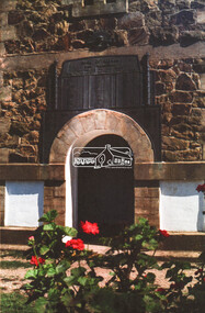
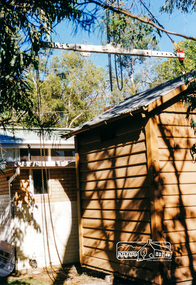 Eltham District Historical Society Inc
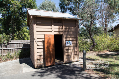
Photograph, Preparing the old Lock-up No. 17 for relocation from Youth Road to the Local History Centre at 728 Main Road, Eltham, March 2001, March 2001
The portable lock up at Eltham is not original to the site. The date of construction is unknown. It is a pre-fabricated design and each of the timber panels are individually numbered on the inside surfaces. It is amongst a large group of portable locks up,categorised as 'Portable Lock Up - Timber - Later' and also known as the "Casterton style", based on the only known plan for portable lock ups, built for the Casterton Police Station, in 1907. The later portables have been in use since the 1880s. It is not known how many lock ups of this type have been constructed in Victoria. At least 50 examples have been documented around the state. Of these, 42 are known to be extant.This lockup used to be located at the Police Station in Pryor Street and was then stored in Youth Road before being acquired for the Local History Centre 9 colour photographseltham, main road, police residence, local history centre, eltham district historical society, courthouse, youth road -
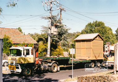 Eltham District Historical Society Inc
Photograph, Lock-up No. 17 arriving at the Local History Centre, 728 Main Road, Eltham, March 2001, March 2001
The portable lockup at Eltham is not original to the site. The date of construction is unknown, believed from the 1880s. It is a prefabricated design and each of the timber panels are individually numbered on the inside surfaces. It is amongst a large group of portable lockups, categorised as 'Portable Lock Up - Timber - Later' and also known as the "Casterton style", based on the only known plan for portable lock ups, built for the Casterton Police Station, in 1907. The later portables have been in use since the 1880s. It is not known how many lock ups of this type have been constructed in Victoria. At least 50 examples have been documented around the state. Of these, 42 are known to be extant. The original 1860s site lockup was a 2-cell bluestone construction. Some of the original bluestone remains. It was used in the 1970s as traffic island edging at the intersection of Main Road and Wattletree Road where it was painted white then later relocated back to this site in the 1980s to be used as edging for a driveway access off Main Road beside the former Police Residence where the Police Station originally stood. Evidence of some of this edging remains in place today leading to the replica Police Station. Other blocks were used to define the garden edging in the carpark at the rear of the residence.This lockup used to be located at the Police Station in Pryor Street and was then stored in Youth Road before being acquired for the Local History Centre 3 colour photographseltham, main road, police residence, local history centre, eltham district historical society, courthouse, youth road -
 Eltham District Historical Society Inc
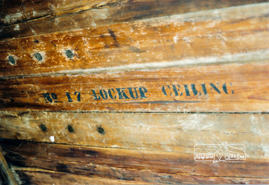
Photograph, Inside panels of No. 17 Lock-up, March 2001, March 2001
The portable lock up at Eltham is not original to the site. The date of construction is unknown. It is a pre-fabricated design and each of the timber panels are individually numbered on the inside surfaces. It is amongst a large group of portable locks up,categorised as 'Portable Lock Up - Timber - Later' and also known as the "Casterton style", based on the only known plan for portable lock ups, built for the Casterton Police Station, in 1907. The later portables have been in use since the 1880s. It is not known how many lock ups of this type have been constructed in Victoria. At least 50 examples have been documented around the state. Of these, 42 are known to be extant.This lockup used to be located at the Police Station in Pryor Street and was then stored in Youth Road before being acquired for the Local History Centre 2 colour photographseltham, main road, police residence, local history centre, eltham district historical society, courthouse, youth road -
 Eltham District Historical Society Inc
Negative - Photograph, Russell Yeoman, Shire of Eltham War Memorial, Memorial Park, Garden Hill, Eltham-Yarra Glen Road, Kangaroo Ground, c.1980
Shire of Eltham War Memorial Tower at Kangarooo Ground; view from the east and close up of entrance including Honour Roll. On November 11th 1926 the Shire of Eltham War Memorial Tower at Kangaroo Ground was opened. It is regarded as one of Melbourne’s most outstanding lookout towers. It commands a magnificent 360 degree panorama from Kinglake across the Diamond Valley to Macedon and the You Yangs. It is built on a peak which was once a volcano, 237 metres above sea level. After World War one a memorial cairn was erected on the site, and in 1925 a committee of public-minded citizens began to plan for a tower. Many generous donations of material and money were forthcoming so that in 1926 the Governor General Lord Stonehaven was able to unveil the plaque before a crowd of 500 people There was some concern in the 1960s when the Forests Commission wanted to build a firespotters cabin on the top. At first R.S.L. branches opposed the idea, but it was realised that this use could combine with its use as a tourist attraction, and would ensure its maintenance for the future. Today the Kangaroo Ground tower provides one of the best views around Melbourne and is a fitting memorial to those who died in two world wars. From: Historic items for Diamond Valley Community Radio September 1990 (EDHS collection) On November 8th, 1951, the memorial was re-dedicated by the Governor of Victoria, Sir Dallas Brooks with the addition of the names of men from the Shire of Eltham who fell in the Second World War. Further wreaths were added subsequent to this image in time for the 2001 Reembrance Day service to commemorate the men from th shire who had fallen in the Malayan, Korean, Borneo and Vietnam campaigns.Roll of 35mm colour negative film, 2 strips Colour print (x1)Kodak Safety 5035garden hill, kangaroo ground, kangaroo ground memorial, memorial park, shire of eltham war memorial tower, war memorial, garden hill, kangaroo ground, kangaroo ground memorial, kangaroo ground relief committee, memorial park, shire of eltham war memorial tower, war memorial, shire of eltham war memorial -
 Eltham District Historical Society Inc
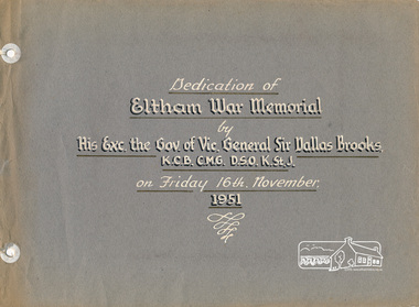
Photo album, Dedication of Eltham War Memorial by His Exc. the Governor of Vic., General Sir Dallas Brooks, K.C.B., C.M.G., D.S.O., K.StJ., on Friday 16th November, 1951, 1952c
On November 11th 1929 the Shire of Eltham War Memorial Tower at Kangaroo Ground was opened. It is regarded as one of Melbourne’s most outstanding lookout towers. It commands a magnificent 360 degree panorama from Kinglake across the Diamond Valley to Macedon and the You Yangs. It is built on a peak which was once a volcano, 237 metres above sea level. After World War one a memorial cairn was erected on the site, and in 1925 a committee of public-minded citizens began to plan for a tower. Many generous donations of material and money were forthcoming so that in 1926 the Governor General Lord Stonehaven was able to unveil the plaque before a crowd of 500 people. There was some concern in the 1960s when the Forests Commission wanted to build a firespotters cabin on the top. At first R.S.L. branches opposed the idea, but it was realised that this use could combine with its use as a tourist attraction, and would ensure its maintenance for the future, Today the Kangaroo Ground tower provides one of the best views around Melbourne and is a fitting memorial to those who died in two world wars. From: Historic items for Diamond Valley Community Radio September 1990 (EDHS collection) Red hard bound binder, 2-ring holder; 18 grey coloured page inserts (3 blank) with 7 photos. Two pages of text in white paint. Also includes inserted leaves of manila card with photocopies of relevant news clippings pasted to card. An additional photo mounted on card dated 1952 has also been inserted into album.eltham, dedication, opening day, sir dallas brooks, kangaroo ground, war memorial, kangaroo ground tower -
 Eltham District Historical Society Inc
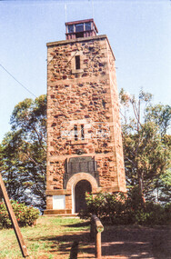
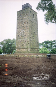
Photograph, Shire of Eltham War Memorial Tower, Memorial Park, Garden Hill, Kangaroo Ground Tower, 6 Aug 1996, 1996
On November 11th 1926 the Shire of Eltham War Memorial Tower at Kangaroo Ground was opened. It is regarded as one of Melbourne’s most outstanding lookout towers. It commands a magnificent 360 degree panorama from Kinglake across the Diamond Valley to Macedon and the You Yangs. It is built on a peak which was once a volcano, 237 metres above sea level. After World War one a memorial cairn was erected on the site, and in 1925 a committee of public-minded citizens began to plan for a tower. Many generous donations of material and money were forthcoming so that in 1926 the Governor General Lord Stonehaven was able to unveil the plaque before a crowd of 500 people. There was some concern in the 1960s when the Forests Commission wanted to build a firespotters cabin on the top. At first R.S.L. branches opposed the idea, but it was realised that this use could combine with its use as a tourist attraction, and would ensure its maintenance for the future, Today the Kangaroo Ground tower provides one of the best views around Melbourne and is a fitting memorial to those who died in two world wars. From: Historic items for Diamond Valley Community Radio September 1990 (EDHS collection) Roll of 35mm colour negative film, 7 stripsKodak Gold 100-5garden hill, kangaroo ground memorial, memorial park, shire of eltham war memorial tower, war memorial tower, war memorials -
 Eltham District Historical Society Inc
Photograph, Shire of Nillumbik World War One Memorials tour, 10 August 2016, 10 August 2016
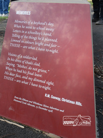
Memories Memories of a boyhood's day. When he went to scahool away Letters in a schoolboy's hand. telling of the things he's planned, Linned in colours bright and fair - THESE - are what I have to-night. Visions of a soldier-led, In his dress of khaki clad, Saying, "Mohter, do not grieve." When he has his final leave. His dear face, and my dimmed signt THESE - are what I have to-night. R.M. Conway, Christmas Hills From the Eltham and Whittlesea Shire Advertiser and Diamond Creek Advocate, 13 December 1918. As part of a program to acknowledge the Anzac Centenary Nillumbik Shire Council partnered with Yarra Plenty Regional Library to provide a bus tour with commentary of local sites of significance. These included Eltham township, the Shire of Eltham War Memorial at Kangaroo Ground, Christmas Hills, Hurstbridge memorial recreation park and finished at Eltham Library to view the Writing the War exhibtion at Eltham Library Community Gallery. In May 2015 Nillumbik Shire Council received Anzac centenary Local Grants Program funding for the restoration and enhancement of Christmas Hills cenotaph as a project to commemorate the First World War. Born Digitalworld war 1, war memorials, shire of nillumbik, christmas hills, interpretative signage, poem, "r.m. conway" -
 Eltham District Historical Society Inc
Photograph, Peter Pidgeon, Eltham Lock-up, 4 Mar 2017
This portable lock up is not original to the site. The date of construction is unknown. It is a pre-fabricated design and each of the timber panels are individually numbered on the inside surfaces. It is amongst a large group of portable locks up, categorised as 'Portable Lock Up - Timber - Later' and also known as the "Casterton style", based on the only known plan for portable lock ups, built for the Casterton Police Station, in 1907. The later portables have been in use since the 1880s. It is not known how many lock ups of this type have been constructed in Victoria. At least 50 examples have been documented around the state. Of these, 42 are known to be extant. This lockup used to be located at the Police Station in Pryor Street and was then stored in Youth Road before being acquired for the Local History Centre in 2001. Lock-up No. 17 taken on the ocassion of the opening of the newly refurbished Eltham Local History Centre Open Day, 4 March 2017, Celebrating 50 years of the Society 1967-2017.Born Digitalactivities, eltham district historical society, local history centre, main road, eltham, 50th anniversary, open day, lock up, lock-up, gaol, jail -
 Kiewa Valley Historical Society
Meteorological Conditions - Bogong High Plains
The amount of rain and snow during the year and over the years was recorded regularly. This was done at several sites and was important for the building of the Kiewa Hydro Electric Scheme which involved dams, power stations and racelines.The KHES depended on accurate and detailed measurements of rain and snow on the Bogong High Plains in order to plan and construct high functioning infrastructure. Photocopy of pages re the Meteorological conditions on the Bogong High Plains including the decades from the 1930s to 1980s. Snow depths are also documented.kiewa hydro electric scheme, meteorological conditions on the bogong high plains, snow depth on the bogong high plains -
 Kiewa Valley Historical Society
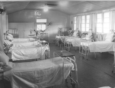
Photograph Tawonga Hospital, A ward at Tawonga Hospital, 1949/50
This photo is of a ward - probably the female ward, as there a many floral arrangements - of the original hospital at Tawonga. This was situated at the corner of Ryders Lane and Kiewa Valley Highway. The building was transported from Bonegilla where it was originally a part of the Bonegilla Military Hospital. The hospital was opened on 24th September, 1949 with a capacity of 12 beds, but was later increased to 35 beds by enclosing the verandahs on 3 sides of the building. 'Add ons' provided theatre, offices, stores and a nurses home. Construction was commenced by the Hospital and Charities Commission with considerable input from the S.E.C., providing the removal and re-erection of the building, the accommodation for nursing staff and carried all work necessary to make the building operational as a hospital. Up until this time the nearest hospital was at Yackandandah. The hospital remained on this site until 1961 when a larger, more suitable building was purchased in Mt. Beauty from the S.E.C.A photographic record of a typical open plan style ward in that era. There were no private rooms. There are portable screens stored at the end of the room to provide "privacy" at the bedside when needed. There is a fan on the wall for cooling. Depicts the rather primitive conditions of that era when compared with todays standards.Black and white photograph of a ward in the Tawonga District Hospitalhospital, ward, tawonga -
 Eltham District Historical Society Inc
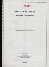
Book, Banyule City Council Aboriginal Heritage Study prepared by Austral Heritage Consultants, 1998 July
A draft report on the pre-European Aboriginal achaeological sites in the city of Banyule, including results of previous field surveys; Banyule covers a small part of the former lands of the Woi Wurrung. The report discusses heritage overlay, planning issues and the proposed Victorian planning provisions.100p, 30 cm.Marked "Draft"aboriginal heritage banyule, woi wurrung