Showing 1183 items matching "municipality"
-
![Cr. G. P. Mackenzie LL.B., J.P., Mayor [of Kew] 1966-67](/media/collectors/550653872162f11fb04854aa/items/5922bfedd0cde9131c3528fe/item-media/5c19e14721ea6d0a58d0ce0c/item-fit-380x285.jpg) Kew Historical Society Inc
Kew Historical Society IncPhotograph, Cr. G. P. Mackenzie LL.B., J.P., Mayor [of Kew] 1966-67, 1966
Kew achieved independence from the Boroondara Roads Board in 1860. As a new municipality, its first three leaders were designated as chairmen. On becoming a borough in 1863, its leaders were identified as mayors. The earliest photographs date from ca.1906, when the Town of Kew commissioned the noted local photographer Josiah E Barnes to produce standardised portraits of former mayors to be displayed in the Mayoral Chamber of the Town Hall. The collection also includes photographs by other well-known photographic studios such as Burlington Studios, Melba – Melbourne, Stuart Tompkins, Spencer Shier and Talma & Co. The majority of mounts identify the photographer. Eighty photographs are housed in their original frames.This portrait is one of a series of mounted and framed photographic portraits of Mayors and Town Clerks of the former Borough, Town and City of Kew, for the period 1863 to 1969. The portraits were transferred by the City of Kew to the Kew Historical Society in March 1989. A Significance Assessment in 2018, funded by the National Library of Australia confirmed the historic, and often artistic significance of the series. Framed portrait of Cr. G. P. Mackenzie, Mayor of Kew 1966-7. The mounting and framing of the photograph follows a typical layout or style in that each is framed in dark wood, glazed, and laid down on an inscribed board. The inscription identifies the name of the mayor and the year/s that he/she served.Cr. G. P. Mackenzie LL.B., J.P. / Mayor 1966-67cr. g. p. mackenzie, mayors of kew (vic), kew (vic.) — municipal collection -
![Cr. H. E. Wiltshire J.P., Mayor [of Kew] 1968-69](/media/collectors/550653872162f11fb04854aa/items/5922c003d0cde9131c353865/item-media/5c19dd6521ea6b0a589ccde0/item-fit-380x285.jpg) Kew Historical Society Inc
Kew Historical Society IncPhotograph, Cr. H. E. Wiltshire J.P., Mayor [of Kew] 1968-69, ca.1969
Kew achieved independence from the Boroondara Roads Board in 1860. As a new municipality, its first three leaders were designated as chairmen. On becoming a borough in 1863, its leaders were identified as mayors. The earliest photographs date from ca.1906, when the Town of Kew commissioned the noted local photographer Josiah E Barnes to produce standardised portraits of former mayors to be displayed in the Mayoral Chamber of the Town Hall. The collection also includes photographs by other well-known photographic studios such as Burlington Studios, Melba – Melbourne, Stuart Tompkins, Spencer Shier and Talma & Co. The majority of mounts identify the photographer. Eighty photographs are housed in their original frames.This portrait is one of a series of mounted and framed photographic portraits of Mayors and Town Clerks of the former Borough, Town and City of Kew, for the period 1863 to 1969. The portraits were transferred by the City of Kew to the Kew Historical Society in March 1989. A Significance Assessment in 2018, funded by the National Library of Australia confirmed the historic, and often artistic significance of the series. Framed portrait of Cr. H. E. Wiltshire J.P., Mayor of Kew during 1968-9. The mounting and framing of the photograph follows a typical layout or style in that each is framed in dark wood, glazed, and laid down on an inscribed board. The inscription identifies the name of the mayor and the year/s that he/she served.Cr. H. E. Wiltshire J.P., / Mayor 1968-69mayor of kew, cr. h. e. wiltshire, kew -- municipal collection -
 Kew Historical Society Inc
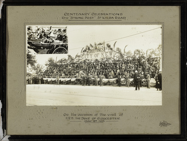
Photograph, The Sears Studio, Centenary Celebrations : Kew "Strong Post" St Kilda Road, 1934
Cr. W.D. Vaughan in 'Kew's Civic History' (1960) records that: "In connection with the Melbourne Centenary Celebrations in 1934, the Kew Council decided to organise a strong post as an appropriate gesture of welcome to H.R.H. the Duke of Gloucester. Also that the municipality be represented by a symbolic floral float in the Royal pageant. This was a striking entry and won first prize, and evoked much comment on account of its originality and truly Australian motif." The photograph of the Kew Strong Post was once part of the Municipal Collection of the former City of Kew and was presented to the Kew Historical Society before the move from the Walpole Street (Kew) Town Hall to new Civic offices in Charles Street in 1971.Historic photograph of participation by the City of Kew in celebrations for a royal visitFramed and glazed photograph on its original inscribed mount and original frame of the Kew "Strong Post" in St Kilda Road on the occasion of the visit to Melbourne of the Duke of Gloucester. The photograph has two components, at the upper left is a photo of the royal carriage while the man photo shows the people of Kew on a decorated 'Strong Post' on St Kilda Road, along which the procession progressed. T"Centenary Celebrations / Kew "Strong Post" St Kilda Road / On the occasion of the visit of / H.R.H. The Duke of Gloucester / October 18th 1934."royal visits - melboure - 1934, duke of gloucester, kew (vic.) — municipal collection -
 Bayside Gallery - Bayside City Council Art & Heritage Collection
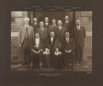
Photograph - gelatin silver photograph, Sarony & Co, The Councillors and Officers of the first City of Sandringham Council, 1923
This photograph records the Councillors and officers on the day that the Town of Sandringham became a City, and the first meeting of the City of Sandringham Council was held. Sandringham was originally part of the Shire of Moorabbin. On 28 February 1917, Sandringham was severed from Moorabbin and incorporated as the Borough of Sandringham. It was proclaimed a Town on 9 April 1919 and a City on 21 March 1923. city of sandringham, councillors, local government, municipality, mayor, cr. h.b. grace, cr. w.h. kay, cr. j.m. ramsay, cr. f.n. gibbs, cr. g.w. knott, cr. r. chisholm, t.g. farrant, cr. c.a. hartsmann, m.h.t. williams, town clerk, cr. j.t.d. beck, m.w.t. sanderland, surveyor -
 Bayside Gallery - Bayside City Council Art & Heritage Collection
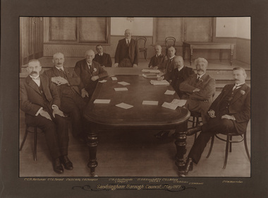
Photograph - sepia photograph, Frazer and Vallance, Sandringham Borough Council, May 1917, 1917
Councillors and the mayor seated at table while attending the first Sandringham Borough Council meeting after severance from the Shire of Moorabbin. Shown L to R: Cr. C.A. Hartsman; Cr. T.G. Farrant; Cr. W.T.C. Kelly; Cr. B. Champion; Cr. B.J. Ferdinando (Mayor) [standing]; Cr. O.R. Snowball Esq. (M.L.A.); Cr. E.L. Belyea; Cr. H. B. Grace; Cr. G.W. Knott; Cr. F.W. Hearnden.councillor, sandringham, local government, municipality, mayor, justice of the peace, cr b.j. ferdinando, borough of sandringham, cr. c.a. hartsman, cr. t.g. farrant, cr. w.t.c. kelly, cr. b. champion, cr. o.r. snowball, cr. e.l. belyea, cr. h. b. grace, cr. g.w. knott, cr. f.w. hearnden, council meeting -
 Bayside Gallery - Bayside City Council Art & Heritage Collection
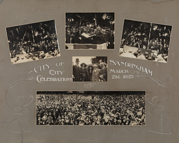
Photograph - sepia photograph, Edwin G. Adamson, City of Sandringham Celebrations, 21st March 1923, 1923
On 21 March 1923, in the presence of 10,000 people, on the City Beach Oval, Sandringham was declared a City by the Earl of Stradbroke. Sandringham was originally part of the Shire of Moorabbin. On 28 February 1917, Sandringham was severed from Moorabbin and incorporated as the Borough of Sandringham. It was proclaimed a Town on 9 April 1919 and a City on 21 March 1923.councillor, sandringham, local government, municipality, mayor, city, proclamation, city of sandringham, lord stradbroke, lady stradbroke, mr. angelo bertotto, city beach oval, crowd, earl of stradbroke, governor, bayside, cr jpd beck, beach oval -
 City of Greater Bendigo - Civic Collection
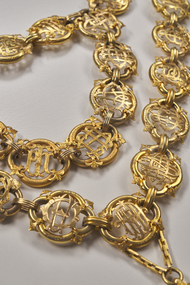
Ceremonial object - City of Bendigo Mayoral Chain, F Prescott Jeweller et al, 1893
The Bendigo mayoral chain or chain of office was donated by George Lansell in 1893 and manufactured from local gold by F Prescott. The design of modern mayoral chains (also known as a livery collar) mimics the ancient gold collar of Esses worn by the Lord Mayor of London which was bequeathed to his successors by Sir John Aleyn (who died in 1545) and which has a large jewelled pendant added in 1607. Source: Wikipedia https://en.wikipedia.org/wiki/Livery_collarDesigned and manufactured by Mr. E. Prescott from 9ct Yellow Gold in 1893 and believed to be made from Bendigo gold, the Bendigo mayoral chain was conceived by Mr J.H. Abbott and created with financial assistance of Mr George Lansell the "Gold King" of Bendigo who contributed the central medallion. The 18 links which made up the original chain represented serving mayors to date and were gifted by ex mayors or their representatives. The main chain consists of 35 links of quatrefoil form with the name of each mayor and the years of their term engraved and filled with black enamel. Overtime, as the chain grew too long to wear, it was separated into two joining chains eventually consisting of another 34 link section, totaling 69 links. The monogram of each mayor in gold is placed in the centre of each link and the links are connected by filigree 9ct gold joining curbs, unique to this period. The engraved central 'drop' or medallion is an eight pointed form with the body being an irregular oval containing four projections and four recesses forming the eight points. The shield section depicts the Australian emblem in miniature above and larger central Bendigo Coat of Arms filled with coloured enamel. The reverse of the medallion bears Lansell's name and is inscribed with the following: / Bendigo gold field discovered in 1851/ proclaimed municipality of Sandhurst /1855 / and city 1871/ Named changed to City of Bendigo 1891, in honor of which event / Cr J. H. Abbott, M.L.C. / inaugurated the mayoral chain / and medallion was presented to the city council / by George Lansell, Esq / to whose implicit belief in the inexhaustible / nature of our gold resources and the idefatigable energy / in developing them Bendigo mainly owns its / present prosperity / June 1893 / W. Honeybone, Town Clerk /sandhurst, bendigo, mayor, mayoral chain, george lansell, prescott, abbott, blashki, council, 1893, city of greater bendigo ceremonial item -
 Glen Eira Historical Society
Document - Memorials in Glen Eira
This file contains one item: 1/A printout from the Victorian Memorials Database, undated and researcher unknown, containing records of 9 memorials in the Caulfield City municipality. These memorials are: - Caulfield Grammar School Site Pavement Marker, Elsternwick - Monument to racehorse ‘Jackstaff’ in Caulfield Racing Museum. - Rosstown Railway Marker, Bambra Road, Caulfield. - Thomas Alexander Browne Grave, Brighton Cemetery. - Grave of Sir John and Lady Monash, Brighton Cemetery. - Frederick Jowett Memorial Drinking Fountain, Caulfield Town Hall - Adam Lindsay Gordon Grave, Brighton Cemetery. - Jewish victims of World War 2 Memorial, Kadimah Centre, Elsternwick. - Hopetown Gardens Cannon, Elsternwick.historical markers, caulfield city, caulfield grammar school, elsternwick, regent street, caulfield racing museum, rosstown railway marker, caulfield, bambra road, curraweena road, marara road, city of caulfield, mayors, councillors, caulfield historical society, rosstown railway, caulfield grammar school pavement marker, monument to racehorse ‘jackstaff’, ross murray, browne thomas alexander, thomas alexander browne grave, brighton cemetery, rolf boldrewood, north road, caulfield south, browne margaret maria, grave of sir john and lady monash, monash john sir, monash hannah victoria lady, frederick jowett memorial drinking fountain, caulfield town hall, hawthorn road, glen eira road, jowett frederick, borough of caulfield, adam lindsay gordon grave, gordon adam lindsay, gordon annie lindsay, jewish victims of world war 2 memorial, kadimah jewish cultural centre and library, selwyn street, burston seddon, hopetoun gardens cannon, glenhuntly road, glen huntly road, schools, historic sites, plaques, footpaths, horseracing, horses, jackstaff, monuments and memorials, railways, authors, cemeteries, graves, gravestones, jewish community, town clerks, shire secretaries, town hall, drinking taps, poetry, children, libraries, world war 1939 – 1945, hopetoun, cannons, festivals and celebrations -
 Kew Historical Society Inc
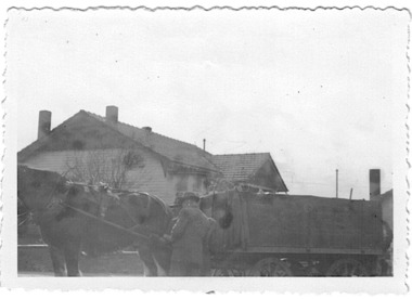
Photograph - Rubbish cart of the City of Kew, 1935-1945
The City of Kew (1860-1994) was a municipality within the boundaries of suburban Melbourne, bordering on the inner suburbs. It was governed by a Council who employed council officers and workers. Services offered to ratepayers included garbage collection. Workers also carried our rubbish removal. From the evidence of photographs, garbage trucks has a semi-circular top with openings on the side of the top and at the rear. Rubbish carts were simple open top containers. Both garbage trucks and rubbish carts were drawn by horses and, in the interwar years and after, operated out of the Council Depot in High Street (formerly the 'horse tramway' sheds and later was to be replaced by the Kew Recreation Centre. The depot was on the corner of High and Disraeli Streets, kew. Small, original black and white positive photograph of a council worker, horse and rubbish cart. This rectangular cart has an open top. An unidentified house is in the background.Annotation in pencil by donor verso: "Kew Council Rubbish cart / Pre & during WWII / from Eliz Bentley"rubbish collection, garbage collection, rubbish carts, city of kew, council workers, horse-drawn vehicles, kew depot -
 Kew Historical Society Inc
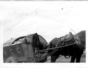
Photograph - City of Kew garbage truck, 1935-1945
The City of Kew (1860-1994) was a municipality within the boundaries of suburban Melbourne, bordering on the inner suburbs. It was governed by a Council who employed council officers and workers. Services offered to ratepayers included garbage collection. Workers also carried our rubbish removal. From the evidence of photographs, garbage trucks has a semi-circular top with openings on the side of the top and at the rear. Rubbish carts were simple open top containers. Both garbage trucks and rubbish carts were drawn by horses and, in the interwar years and after, operated out of the Council Depot in High Street (formerly the 'horse tramway' sheds and later was to be replaced by the Kew Recreation Centre. The depot was on the corner of High and Disraeli Streets, kew. Small, original black and white positive photograph of a City of Kew horse and garbage cart. The rectangular cart has a curved roof with openings at the side. A large door at the back allowed for the removal of garbage. K.C.C. is written on the side of the cart.Annotation in pencil by donor verso: "From E. Bennett / Kew City C'cil used during and after WW2 / from E. Bentley"rubbish collection, garbage collection, rubbish carts, city of kew, council workers, horse-drawn vehicles, kew depot -
 Kew Historical Society Inc
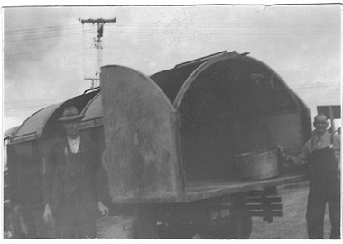
Photograph - City of Kew garbage cart, 1935-1945
The City of Kew (1860-1994) was a municipality within the boundaries of suburban Melbourne, bordering on the inner suburbs. It was governed by a Council who employed council officers and workers. Services offered to ratepayers included garbage collection. Workers also carried our rubbish removal. From the evidence of photographs, garbage trucks has a semi-circular top with openings on the side of the top and at the rear. Rubbish carts were simple open top containers. Both garbage trucks and rubbish carts were drawn by horses and, in the interwar years and after, operated out of the Council Depot in High Street (formerly the 'horse tramway' sheds and later was to be replaced by the Kew Recreation Centre. The depot was on the corner of High and Disraeli Streets, kew. Small, original black and white positive photograph of a City of Kew garbage cart and two council workers. The rectangular cart has a curved roof with openings at the side. A large door at the back allowed for the removal of garbage. Annotation in pencil by donor verso: "From E. Bentley / used during and after WW2 / Kew Garbage Truck"rubbish collection, garbage collection, rubbish carts, city of kew, council workers, horse-drawn vehicles, kew depot -
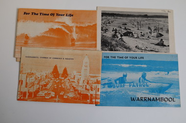 Warrnambool and District Historical Society Inc.
Booklet - Warrnambool Tourist Guides (5), Warrnambool Chamber of Commerce and Industry, Warrnambool - For the Time of Your Life, 1970-1975
Warrnambool Tourist Guides 1970-1975.1,.2,.3 - These are booklets of 36 pages with an orange cover with an illustration of two people on surf boards on the front cover and an image of a main street on the back cover. The cover has blue printing. The pages contain a map, advertisements, black and white photographs and printed text. One booklet is stapled and two have the staples removed. .4,.5 -These are booklets of 40 pages with a front cover with a photograph in blue tones of a surf patrol boat and two lifesavers and a back cover with a black and white photograph (beach scene). The pages contain a map, advertisements, black and white photographs and printed text. One booklet is stapled and one has the staples removed. non-fictionWarrnambool Tourist Guides 1970-1975warrnambool tourism, tourism in warrnambool in the 1970s -
 Narre Warren and District Family History Group
Textile, City of Berwick, Rosette/Ribbon Riding the Bounds City of Berwick 1991
The Riding of the Bounds was an annual event that took place in Berwick. It linked back to a centuries-old tradition in sister city Berwick upon Tweed, England. Riders followed a route through local streets and participate in ceremonies along the city's border. The Mayor would wave off riders from the local showgrounds with instructions to inspect the boundary with the neighbouring municipality. Once the ride was complete, the Marshall would report back to the Mayor that the boundaries were secure, and this would herald the commencement of the presentation ceremony. This re-enactment of the Berwick-Upon-Tweed Riding of the Bounds was filled with pomp and ceremony and many of the riders took the opportunity to dress in period costume in recognition of the history of this event. This information is from https://collection.casey.vic.gov.au/Ribbon for City of Berwick Riding the Bounds 19919. Printed on white material with blue ink. Has the City of Berwick coat of arms at the top of the ribbon.city of berwick, riding the bounds, city of berwick coat of arms, horses, berwick boundaries -
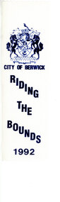 Narre Warren and District Family History Group
Textile, City of Berwick, Rosette/Ribbon Riding the Bounds City of Berwick 1992
The Riding of the Bounds was an annual event that took place in Berwick. It linked back to a centuries-old tradition in sister city Berwick upon Tweed, England. Riders followed a route through local streets and participate in ceremonies along the city's border. The Mayor would wave off riders from the local showgrounds with instructions to inspect the boundary with the neighbouring municipality. Once the ride was complete, the Marshall would report back to the Mayor that the boundaries were secure, and this would herald the commencement of the presentation ceremony. This re-enactment of the Berwick-Upon-Tweed Riding of the Bounds was filled with pomp and ceremony and many of the riders took the opportunity to dress in period costume in recognition of the history of this event. This information is from https://collection.casey.vic.gov.au/Ribbon for City of Berwick Riding the Bounds 1992. Printed on white material with blue ink. Has the City of Berwick coat of arms at the top of the ribbon.city of berwick, riding the bounds, city of berwick coat of arms, horses, berwick boundaries -
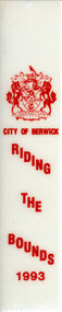 Narre Warren and District Family History Group
Textile, City of Berwick, Rosette/Ribbon Riding the Bounds City of Berwick 1993
The Riding of the Bounds was an annual event that took place in Berwick. It linked back to a centuries-old tradition in sister city Berwick upon Tweed, England. Riders followed a route through local streets and participate in ceremonies along the city's border. The Mayor would wave off riders from the local showgrounds with instructions to inspect the boundary with the neighbouring municipality. Once the ride was complete, the Marshall would report back to the Mayor that the boundaries were secure, and this would herald the commencement of the presentation ceremony. This re-enactment of the Berwick-Upon-Tweed Riding of the Bounds was filled with pomp and ceremony and many of the riders took the opportunity to dress in period costume in recognition of the history of this event. This information is from https://collection.casey.vic.gov.au/Ribbon for City of Berwick Riding the Bounds 1993. Printed on white material with red ink. Has the City of Berwick coat of arms at the top of the ribbon.city of berwick, riding the bounds, city of berwick coat of arms, horses, berwick boundaries -
 Narre Warren and District Family History Group
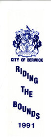
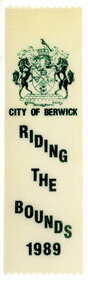
Textile, City of Berwick, Rosette/Ribbon Riding the Bounds City of Berwick 1989
The Riding of the Bounds was an annual event that took place in Berwick. It linked back to a centuries-old tradition in sister city Berwick upon Tweed, England. Riders followed a route through local streets and participate in ceremonies along the city's border. The Mayor would wave off riders from the local showgrounds with instructions to inspect the boundary with the neighbouring municipality. Once the ride was complete, the Marshall would report back to the Mayor that the boundaries were secure, and this would herald the commencement of the presentation ceremony. This re-enactment of the Berwick-Upon-Tweed Riding of the Bounds was filled with pomp and ceremony and many of the riders took the opportunity to dress in period costume in recognition of the history of this event. This information is from https://collection.casey.vic.gov.au/ Ribbon for City of Berwick Riding the Bounds 1989. Printed on white material with green ink. Has the City of Berwick coat of arms at the top of the ribbon. city of berwick, riding the bounds, city of berwick coat of arms, horses, berwick boundaries -
 Narre Warren and District Family History Group
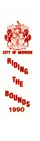
Textile, City of Berwick, Rosette/Ribbon Riding the Bounds City of Berwick 1990
The Riding of the Bounds was an annual event that took place in Berwick. It linked back to a centuries-old tradition in sister city Berwick upon Tweed, England. Riders followed a route through local streets and participate in ceremonies along the city's border. The Mayor would wave off riders from the local showgrounds with instructions to inspect the boundary with the neighbouring municipality. Once the ride was complete, the Marshall would report back to the Mayor that the boundaries were secure, and this would herald the commencement of the presentation ceremony. This re-enactment of the Berwick-Upon-Tweed Riding of the Bounds was filled with pomp and ceremony and many of the riders took the opportunity to dress in period costume in recognition of the history of this event. This information is from https://collection.casey.vic.gov.au/Ribbon for City of Berwick Riding the Bounds 199. Printed on white material with red ink. Has the City of Berwick coat of arms at the top of the ribbon.city of berwick, riding the bounds, city of berwick coat of arms, horses, berwick boundaries -
 Uniting Church Archives - Synod of Victoria
Photograph - Newspaper cutting, 2 March 1984
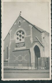
The Gipps Street Wesleyan Methodist Church of 1874 and the adjoining school hall, were built in the Collingwood Flat area - one of the municipality's poorest areas. In 1903, the Collingwood Methodist Mission was established with its headquarters in the Gipps Street Church. Six Methodist Missions were created in inner Melbourne. Three churches were operated by the Collingwood Mission. They were: Sackville Street Collingwood, Elizabeth Street, North Richmond (demolished), and Gipps Street Collingwood (demolished). The Mission operated until approximately 1930. The Wesleyan Church and School in Sackville St. Collingwood was built in 1886 and used as a church for 65 years. It was also part of the Collingwood Methodist Mission before being converted to an industrial/commercial complex. The church was auctioned on 3 March 1984.The cutting gives information about the history of the Church at 25 Sackville St. Collingwood prior to its auction sale on 3 March 1984gipps st. methodist church, les gorrie, collingwood mission, sackville street church, wesleyan -
 Uniting Church Archives - Synod of Victoria
Photograph, undated
The Gipps Street Wesleyan Methodist Church of 1874 and the adjoining school hall, were built in the Collingwood Flat area - one of the municipality's poorest areas. In 1903, the Collingwood Methodist Mission was established with its headquarters in the Gipps Street Church. Six Methodist Missions were created in inner Melbourne. Three churches were operated by the Collingwood Mission. They were: Sackville Street Collingwood, Elizabeth Street, North Richmond (demolished), and Gipps Street Collingwood (demolished). The Mission operated until approximately 1930. The Wesleyan Church and School in Sackville St. Collingwood was built in 1886 and used as a church for 65 years. It was also part of the Collingwood Methodist Mission before being converted to an industrial/commercial complex. The church was auctioned on 3 March 1984.B & W exterior view of the Sackville St. Collingwood Methodist Mission. gipps st. methodist church, les gorrie, collingwood mission, sackville street church, wesleyan -
 Ballarat Heritage Services
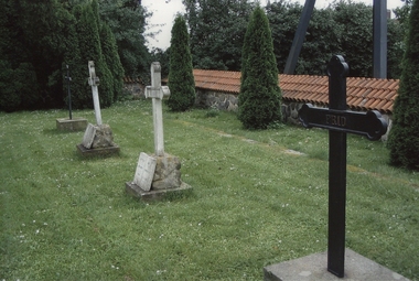
Digital photograph, Denise Kinnane, Graves, Robelofs church, 2007
These graves are situated at a small medieval church that is a popular baptismal and wedding church. It is part of the Råbelöv estate in Kristianstad Municipality, Scania, in southern Sweden. They are the graves of Douglas and his brother. In 1906, the eldest son of James Kennedy, Douglas Kennedy, the future fidei commissioner, took his life. Four years later another son took his life. James and his wife took the disasters hard, they fell ill. The young son Gilbert got in 1908, only 22 years old, took over responsibility for the farm. James son Gilbert Kennedy took over as Fidei Commissioner in 1916 and they became known as outstanding farmers with, among other things, grazing for dairy cows and fruit growing as specialties. Digital photographkristianstadt, kennedy, sweden, råbelöv, church, castle, graves, douglas kennedy -
 Kew Historical Society Inc
Photograph - 'Neama', Studley Park Road, 1978
Edward Augustus Atkyns was born in Wiltshire, England in 1840. His family emigrated to Australia in 1852. As a young man he was a keen cricketer and played at the first cricket ground in the district, located between Barkers Road and Hawthorn Grove, on the site of the future Barker railway station. Atkyns was admitted to the Victorian Bar in 1861, initially working in his father’s practice. He sat as a local magistrate in both Kew and Hawthorn and acted as solicitor for several shire councils. Elected to the Hawthorn Borough Council in 1863 at the age of 23, he served in that municipality as mayor in 1866-67. By 1877, he had moved to Kew where he lived at Neama in Studley Park Road, a property later incorporated into the St Paul’s School for the Blind.Rare colour photograph of what was once a significant house in Kew.Original colour positive photograph (Kodak print) of the main house of 'Neama', colloquially known as the 'farmhouse'. Photographed by Stewart West in April 1978 (it was later demolished by the Villa Maria Society).Annotated reverse: "Front view of Neama / Farmhouse on St Paul's School for the Blind Children / Fernhurst Estate"st paul's school for the blind, neama, studley park road -- kew (vic.), historic houses -- kew (vic.), villa maria society -
 Kew Historical Society Inc
Photograph - 'Neama', Studley Park Road, 1978
Edward Augustus Atkyns was born in Wiltshire, England in 1840. His family emigrated to Australia in 1852. As a young man he was a keen cricketer and played at the first cricket ground in the district, located between Barkers Road and Hawthorn Grove, on the site of the future Barker railway station. Atkyns was admitted to the Victorian Bar in 1861, initially working in his father’s practice. He sat as a local magistrate in both Kew and Hawthorn and acted as solicitor for several shire councils. Elected to the Hawthorn Borough Council in 1863 at the age of 23, he served in that municipality as mayor in 1866-67. By 1877, he had moved to Kew where he lived at Neama in Studley Park Road, a property later incorporated into the St Paul’s School for the Blind.Rare colour photograph of what was once a significant house in Kew.Original colour positive photograph (Kodak print) of the secondary building at 'Neama', colloquially known as the 'hall'. Photographed by Stewart West in April 1978 (it was later demolished by the Villa Maria Society).Annotated reverse: "Timber hall on Fernhurst land / Transported there approx 1878."st paul's school for the blind, neama, studley park road -- kew (vic.), historic houses -- kew (vic.), villa maria society -
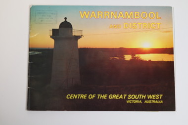 Warrnambool and District Historical Society Inc.
Booklet - Tourist Booklet, Warrnambool Chamber of Commerce and Industry, Warrnambool and District - Centre of the Great South West, Victoria, Australia, c. 1970
Warrnambool Tourist BookletThis is a booklet of 22 pages. The cover has two colour photographs and the pages contain a sketch map, printed text and colour photographs. The pages have ben stapled but the staples have been removed.non-fictionWarrnambool Tourist Bookletwarrnambool tourism, south west victoria tourist locations, warrnambool chamber of commerce -
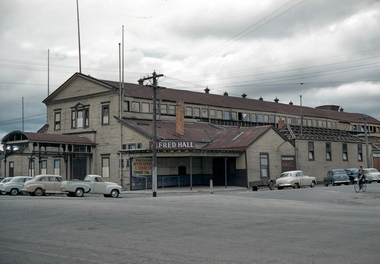 City of Ballarat Libraries
35mm Slide, Alfred Hall, corner Curtis and Grenville Streets, Ballarat circa 1950s
Demolition appears to be under way in this image of the Alfred Hall. It was built in 1867 for the visit of Queen Victoria's son Prince Alfred the Duke of Edinburgh, across the Yarrowee (which formed the municipal boundary) apparently because the municipalities of Ballarat and Ballarat East could not decide who should have the honour! The Alfred Hall held many of the city's events over 89 years, but was symbolically locked up the day the Civic Hall in Mair Street was officially opened, in August 1956. Mrs Bon Strange and her husband Bert were well known Ballarat residents. When Mrs Strange died some years ago, her extensive slide collection was sorted through and those relevant to Ballarat were gifted to the Ballarat Library. alfred hall, curtis street, holden cars, ballarat -
 Seaworks Maritime Museum
Plaque
Wooden plaque with metal plate with English and Japanese writing "In Commemoration of FRIENSHIP PORTS' Day/ On the occasion of the Yokohama Exotic Showcase '89, celebrating/ Yokohama's centennial as a municipality and the 130th anniversary of the/ opening of is port, 29 August 1989 has been designated as Friendship Ports'/ Day. The day's activities and the participation of Melbourne have brought/ about mutual understanding and have strengthened the ties of/ friendship between Melbourne and Yokohama./ We present this plaque as a symbol of our deep appreciation and of/ our desire for continued friendship and exchange/ 29 August 1989/ Nichachiro Hanamura/ Chairman/ Association for the Yokohama Exotic Showcase '89" Japanese writing on reverse : "PMA 0135" -
 Ballarat Tramway Museum
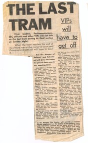
Newspaper, The Courier Ballarat, "The last tram - VIPs will have to get off", 18/09/1971 12:00:00 AM
Newspaper clipping from The Courier, Ballarat, Saturday 18/9/1971 about the details of the last trams to run in Ballarat, and that only tramway employees will be allowed to ride back to the depot from Sturt St. Notes that the Mayors of Ballarat and Sebastopol will drive the trams for part of their runs in the municipalities. Quotes tramway superintendent Mr. L. J. Denmead. Gives times the last trams were time to leave the Lydiard St North terminals, that 40 is to be the last tram, that it was to be driven by Mr. L. Walker with Mr. H. Knight as conductor. Ballarat Mayor, Cr. Chisholm was to receive the last tram at the depot. At base of item, notes that The Courier is to provide a 12 page supplement on the history of the Ballarat trams and photos. "Orders for this supplement have been particularly heavy". Second copy added 31/10/2005. Image added 2/9/15 - from a cutting donated by Joy Watson - actual cutting not collection as duplicated. In blue ink in the top right hand area of the item - 'Sat / 18/9/71'trams, tramways, closure, last tram, 40, sebastopol -
Ballarat Tramway Museum
Document - Report, State Electricity Commission of Victoria (SECV), "Electricity Supply Department - Geelong Tramways Review 1953", 1953
Demonstrates a document prepared by the SEC promoting the closure of the Geelong system. Yields historical notes and statistics on the Geelong Tramway system - very detailed information about tram use, services, staffing and routes and the costs of continuing the system in use.Sixteen page carbon copy foolscap document titled "Electricity Supply Department - Geelong Tramways Review 1953". Headings are: Early History, Creation of the SEC, Acquirement by the SEC, Agreements with Municipalities, SEC Act, Municipal By-Laws (Buses), proposed extension of the tramway routes, physical characteristics and changes at Geelong, Outlook of SEC as to tramways, Attempts to define transport future, review by the Geelong Tramway Operation by the SEC, tramcars, fares, staff and employees, trams used in normal traffic, daily mileage, average speed of services, service summary, passenger density, present outlook, prospective cost to be faced if existing system is continued, Possible improvements to the present system, extensions to the present tramway system, conclusions. Probably prepared as one of the reports to be considered by Government in its decision to close the Geelong system in 1956. Parts of text have been used in Reg Item 3478 - Geelong history and statistics. Very good reference document.'BTPS 403" in top right hand corner.trams, tramways, geelong, sec, mesco, history -
 Melbourne Tram Museum
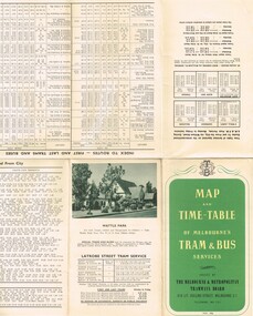
Map, Melbourne & Metropolitan Tramways Board (MMTB), "Map and timetable of Melbourne Tram and Bus Services" - May 1956", May. 1956
Fold out map (10 sections), coloured of Melbourne's Tram and Bus routes, route numbers, rail lines, municipalities boundaries and location of major places of interest. Titled - "Map and timetable of Melbourne Tram and Bus Services" - May 1956". At base of map - timetable of all night trams and bus services. On rear index to routes, 1st and last services, time of Sunday am services, LaTrobe St. services and photo of Wattle Park. Dated May 1956. Note the inset map shows Bourke St as a bus. Three copies held. 413.1 - as for above but with a pasted over section titled "Time table of all - night bus services" on the base of the map replacing the all night tram and bus services. Dated 3/7/1957. Copy from donation of Gary Butler added 3/12/15. See Reg Item 2300 for the March 1952 version.trams, tramways, melbourne, map, tram & bus services, all night services, mmtb -
 Eltham District Historical Society Inc
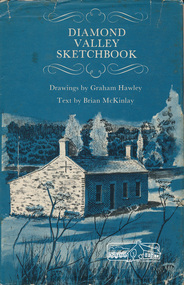
Book, Diamond Valley sketchbook / text by Brian McKinlay ; drawings by Graham Hawley, 1973
Contents include short articles and illustrations of historic properties within the municipalities of Banyule, Nillumbik and Whittlesea. Including The Griffin House, Rosehill, Lower Plenty, The Austin Hospital, Heidelberg, St John's Church, Heidelberg, Banyule, Heidelberg, Trestle Bridge, Eltham, Diamond Valley railway, The Shillinglaw Cottage, Eltham, Montsalvat, Old England Hotel, Heidelberg, Eltham Primary School, Mud brick homes, Eltham, Sweeney's Cottage, Eltham, Pound Pend Tunnel, The Gold Memorial, Potter's Cottage, Memorial Tower, Charterisville, Weller's Pub, The Barrel, Eltham, Hassall's Gallery, The Old Bridge, Greensborough, Diamond Valley Shire Offices, Greensborough, St Katherine's Chapel, Yan Yean Reservoir, Mernda Hotel, Mernda Mechanics Institute, Old Barn, Mernda, Parade College, La Trobe University.Hardback with jacket ; 63 p. : ill., maps ; 22cm. diamond valley shire, shire of nillumbik, city of whittlesea, city of banyule, shillinglaw cottage, weller's hotel -
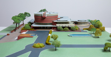 Bayside Gallery - Bayside City Council Art & Heritage Collection
Model, Alan W. Chandler, Brighton Municipal Complex, 1959
This model of the Brighton Municipal Offices was made by Alan W. Chandler. The Brighton Municipal Offices were designed by Kevin Knight of Oakley and Parkes with the engineers John Connell and Associates and were erected by Prentice Builders Pty Ltd. The foundation stone was laid on 13 February 1959 and the building was opened on 21 July 1961. The interior decoration and furniture was by Grant Featherston. As is common practice, an architectural model was prepared to present the final concept of the building for approval to the Brighton City Council. In February 1959 festivities occurred to celebrate the centenary of the municipality of Brighton. A garden party attended by two hundred Brighton residents was held in the grounds of the Brighton Town Hall. This model graced the centre of the lily pond during the event. The following day the foundation stone of the Brighton Municipal Offices was laid.Architectural model of a large public building in orange brick, the main cylindrical tower is set within a rectangular structure, with circular and oval roof structures. The model is set within landscaped grounds with paths, a water feature, several trees and bushes, lawns and flower beds.brighton municipal complex, brighton civic centre, brighton chambers, architectural model, model, alan w. chandler, kevin knight, oakley and parkes, architecture, municipal offices, municipal building, scale model