Showing 1043 items
matching quarrying
-
 Orbost & District Historical Society
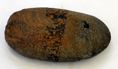
axe head
Inspected by archaeologist, Joanna Freslov on 2.6.2008. Stone tools were used for a variety of purposes, in ways similar to those of steel knives, axes, hammers and chisels. Ground-edge tools are made from fracture-resistant stone, such as basalt.This is able to withstand repeated impact, and and so was suitable for use in objects such as stone axes. The stone was quarried, and then roughly shaped into a tool blank with blows from a hammerstone. The edges were then sharpened and refined by grinding the tool against a coarse, gritty rock. The necessary tools and equipment for hunting, fishing and warfare were some of the very few items that Aboriginals carried with them from place to place. Most were used for a multiplicity of purposes. Because many were made from raw natural materials, such as wood, generally only partial remains are found today. This artefact is an exaample of the stone tools that Aboriginal people used.A dark stone handmade Aboriginal axe head.aboriginal axe-head stone-artefacts tool -
 Orbost & District Historical Society
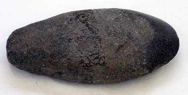
axe head
Inspected by Joanna Freslov, archaeologist 2.6.2008. Stone tools were used for a variety of purposes, in ways similar to those of steel knives, axes, hammers and chisels. Ground-edge tools are made from fracture-resistant stone, such as basaltwhich is able to withstand repeated impact, and is suitable for use in objects such as stone axes. The stone was quarried, and then roughly shaped into a tool blank with blows from a hammerstone. The edges were then sharpened and refined by grinding the tool against a coarse, gritty rockThe necessary tools and equipment for hunting, fishing and warfare were one of the very few items that Aboriginals carried with them from place to place. Most were used for a multiplicity of purposes. Because many were made from raw natural materials, such as wood, generally only partial remains are found today. This axe head is an example of an early stone tool used by the Indigenous people of Eastern Australia.A handmade stone Aboriginal axe head.aboriginal tool stone-artefact axe-head -
 Orbost & District Historical Society
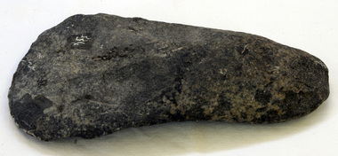
axe head
Inspected by Joonna Freslov, archaeologist 2.6.2008. Stone tools were used for a variety of purposes, in ways similar to those of steel knives, axes, hammers and chisels. Ground-edge tools are made from fracture-resistant stone, such as basalt which is able to withstand repeated impact, and is suitable for use in objects such as stone axes. The stone was quarried, and then roughly shaped into a tool blank with blows from a hammerstone. The edges were then sharpened and refined by grinding the tool against a coarse, gritty rock.The necessary tools and equipment for hunting, fishing and warfare were one of the very few items that Aboriginals carried with them from place to place. Most were used for a multiplicity of purposes. Because many were made from raw natural materials, such as wood, generally only partial remains are found today. This axe head is an example of an early stone tool used by the Indigenous people of Eastern Australia.A handmade stone Aboriginal axe head. Finger grips are clear.axehead aboriginal tool stone-artefact -
 Melbourne Legacy
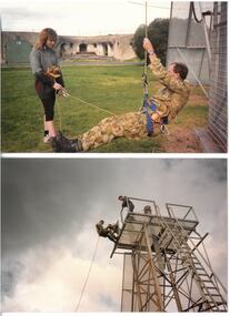
Photograph, Abseiling training, 08/1989
Photos of abseiling training in preparation for abseiling down the Gas and Fuel buildings in Flinders St with Ron Barassi in August 1989 - see 00508 and 01409. The event was for Legacy Week 1989. Details of the event said Ron Barassi abseils for Legacy joined by Carol Shaw and Legatee Peter Heeney. Media team watching them were Fox's Wally Weissel and Ken Kavanagh and Triple M's Andy McLean. Aided by Williamstown Commando Company with training at Nidrie Quarry.A record of a promotional event.Colour photo x 4 of training for an abseiling event.legacy promotion, legacy week -
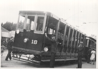 Ballarat Tramway Museum
photograph - Set of 3 Black & White - ESCo trams Bendigo - Easter, Peter Duckett, c1947
Set of three photographs of early Bendigo trams photographed by Peter Duckett, Easter Monday 1946 or 1947 1 - Bendigo 18 - note the white disc held by a crew member. View St at Charing Cross. Tram has the destination of City. 2 - Original car No. 9 (in final form) and open bench car, either 17 or 18, probably at Ironbark Gully loop. Tram has destination of Quarry Hill. 3 - Original ESCo cars - Charing Cross.Yields information about Bendigo trams during Easter 1946 or 1947Set of three black and white photographs by Peter Duckett.Details the image on the rear of the print in ink.bendigo, tramcars, esco, bendigo tramways, tram 18, tram 9, charing cross, easter -
 Melbourne Legacy
Photograph, Ron Barassi abseiling, 1989
A photo of Ron Barassi training in preparation for abseiling down the Gas and Fuel buildings in Flinders St in August 1989 for Legacy week - see 00508. Aided by Williamstown Commando Company with training at Nidrie Quarry. Ron Barassi was a Legacy boy after his father died in Tobruk. He donated a lot of time and was involved with Legacy in many ways over the years. Including being personality of the year in 1989 and his photo featured on the presidents highlight report in 1989.A record of a promotional event involving Ron Barassi.Black and white photo of Ron Barassi training for an abseiling event.legacy promotion, ron barassi -
 Bacchus Marsh & District Historical Society
Map, Limestone Reserve Parish of Merrimu 1888
Limestone deposits in the Coimadai area 10 kilometers north of Ballarat were first worked in the 1850s. The area was quarried for limestone for many years by various people and companies. The surveyor's name who produced this plan is inscribed on the map and below this is the name P. L. Alkemade, who presumably paid for the map to be produced. In 1886 Petrus Alkemade in partnership with Matthew Egan established the Alkemade Hydraulic Lime and Cement Company. The Alkemade family were involved in the limestone industry over several generations at Coimadai.Single page map showing part of the Limestone reserve near Coimadai in the Parish of Merrimu. Scale 4 chains to 1 inch. Part of a set of maps which are pasted into a bound volume containing 76 maps or plans in total. High resolution digital image stored on BMDHS computer network. Copy of plan surveyed by Mr. G? [illegible] an authorised surveyor on 17th July 1888. P. L. Alkemadebacchus marsh victoria maps, lime kilns coimadai, limestone, coimadai victoria maps, alkemade family coimadai -
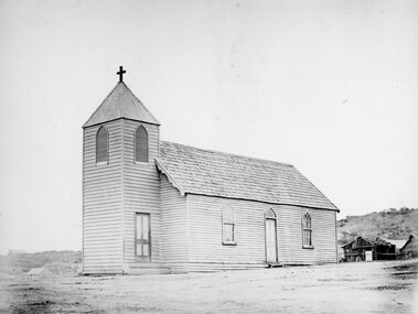 Stawell Historical Society Inc
Photograph, Wooden Catholic Church, Reefs Pleasant Creek, built about 1865
Wooden Catholic Church Reefs built about 1865. Part of a collection of Photographs by Mr. O.G. Armstrong as commissioned by the Shire of Stawell for the Inter-colonial and Paris Exhibition in Melbourne in 1866. This wooden building was built about 1865 on a site held by minors right, near the present Stawell Courthouse. It was situated on a track later to become Patrick St. The present St Patricks church is built of granite, quarried in the nearby Black Range with facings of Grampians Freestone and was opened in 1873. Wooden Church with large bell tower with door at front. The edge slope of Big Hill can be seen at right.stawell religion -
 Eltham District Historical Society Inc
Photograph, Peter Pidgeon, White Cloud Cottage, 701 Main Road, Eltham, 2 Aug. 2022
Jarrold Cottage built c.1853, also known as 'White Cloud", located at 701 Main Road, Eltham, opposite Dalton Street. The house remains intact and is listed on the Victorian Heritage Database and considered historically significant to the Shire of Nillumbik. The cottage was originally located closer to the Diamond Creek but was subject to flooding. It was dragged by horse to the present site shown, which was chosen for the higher ground that had been created as a result of land fill being deposited here from the quarry further around the bend on Main Road (site of present-day Eltham Primary School carpark) where the stone had been quarried for building the State School in Dalton Street. It had previously been rented for use as a Police Station / residence prior to the building of the permanent police house and station at the corner of Maria and Brougham streets in 1859. The cottage was purchased by Lena Skipper after the death of Thekla Jarrold in 1943 and remains in the family to present day (2022). Part of a presentation by Peter Pidgeon to the Society, 13 August 2022 showcasing a series of photographs taken by John Henry Clark over the period 1895 to 1930.Born Digitaleltham, dalton street, main road, bootmaker's shop, jarrold cottage, white cloud cottage -
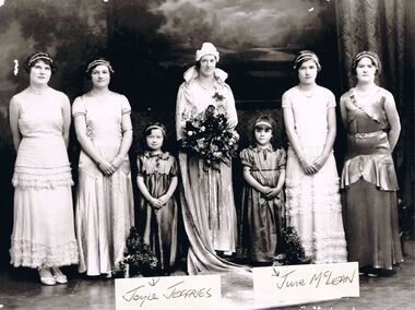 Bendigo Historical Society Inc.
Photograph - PATRICIA COLES (NEE MCLEAN) COLLECTION: BENDIGO EASTER PARADE QUEEN COMPETITION 1930
Photograph.The Patricia Coles (nee McLean) collection. Bendigo Easter Parade Queen Competition 1930. Copy of a black and white photograph. Four women and two small girls. The Easter Queen holds a large bouquet. The two small girls are identified. Joyce Jeffries, on the left, daughter of Mary & Joe Jeffries, Quarry Hill hoteliers. On the right, June McLean, daughter of Nellie & Tom McLean, United Kingdom Hotel, Golden Square.bendigo, entertainment, easter parade queen competition, bendigo easter fair. bendigo easter parade queen compettion. mclean family of golden square. united kingdom hotel. -
 Bendigo Historical Society Inc.
Document - BASIL MILLER COLLECTION: TRAMS, CHRISTMAS SPECIAL ROSTER, c1968
Graph paper. Roster-24 minutes service from 10 am to 11 pm Christmas Day, Wednesday 25th December, 1968, Eaglehawk to Quarry Hill. Labor Day Monday 10th March 1969, News Year Day-Wednesday 1st January 1969. Boxing Day Thursday 26th December 1968. Time tables include Motormen and Conductors names. Markings/Inscriptions: X.MAS. 1968 & NEW YEARS DAY 1969.organization, business, bendigo trams, basil miller -
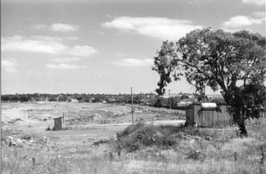 Darebin Parklands Association
Rockbeare Park 1970s, 1973-1980
B&W photograph of the area which was to become the Darebin Parklands. Shows toilet and other buildings which were probably part of old bluestone quarry operation. The tree at right is still standing (at 2014). The path behind is the extension of Separation Street. This item and all other Darebin Parklands Association archival material is now held by State Library Victoria (Accession No: YMS 13746). Please contact State Library Victoria if access is required. -
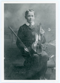 Mt Dandenong & District Historical Society Inc.
Photograph, Edward John Price aged 14
John Lundy-Clarke grew up in the Kalorama/Mt Dandenong area and later in life (1972-74) began to write a comprehensive history of the district working from an original settlement map in an effort to cover all areas. Edward John Price (1898 - 1974) was the son of early settlers on Lot 1 of the Village Settlement Edward Joseph Price and Annie (nee Ross) Price. He was the brother of Charles and Kathleen Price. Edward John married Myra Wilson in 1930.Black and white studio portrait showing well groomed boy holding a violin. Reverse of photograph has handwritten description by John Lundy-Clarke.Edward John Price aged 14. Son of Edward Joseph Price and Annie Ada nee Ross. Farmer, sawmiller, logging contractor,. proprietor of shop at Kew Junction 1935. Quarry master (Kilsyth). Father of Alan and Eddie J. A daughter died young. Married Myra Wilson 1930. Died 1974.edward john price, edward joseph price, annie price, annie ross, kathleen price, charles price -
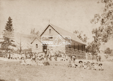 Eltham District Historical Society Inc
Photograph, Eltham State School No. 209, Dalton Street, Eltham, c.1895
Second school building on same site, which was put out for tender in April 1875. The stone building is prior to any additions. Note children playing in school yard. Published in Nillumbik Mail Edition 21, 20 Sep Harry Gilham's notes: Constructed 1875. Inspection finished 31 December 1875 - outer walls covering said to come from Quarry Park at the western end of cuyrrent Lavender Park Road, Eltham. Windows altered in the 1900s; ventilation and skylights 1920s - built to house 100 children.Sepia photograph mounted on cardNillumbik Mail publication details; Edition 21, 20 Sepdalton street, eltham, eltham state school no. 209, school group, eltham primary school -
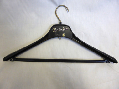 Warrnambool and District Historical Society Inc.
Domestic object - Fletcher Jones Coat Hanger, Late 20th century
David Fletcher Jones commenced his tailoring and hawking business in the 1920’s. The business expanded through the decades to become the main manufacturing employer in the city of Warrnambool. The business moved from Liebig Street around 1947 to a site in East Warrnambool which was once an old quarry. The factory which was built at “Pleasant Hill” manufactured quality clothing, initially men’s trousers, suits which expanded in later times to include ladies’ wear. A network of stores was opened throughout Australia to sell the garments. A common item linked to a significant business and personality of Warrnambool.Fletcher Jones Factory held a significant place in the economic development of the city. The Fletcher Jones Gardens remain a significant landmark in the cityBlack plastic coat hanger with metal hook. Fletcher Jones in gold lettering below the hook.warrnambool, fletcher jones, pleasant hill, fletcher jones gardens, coathanger -
 Harcourt Valley Heritage & Tourist Centre
B & W photograph of fourteen men dressed in bowls club uniforms, Harcourt Bowling Club BDBA Pennant Winner Division 3 Season 1966-67, 1967
The inaugural meeting to form Harcourt Bowling Club was held in May 1955. Cr Ben Bingham donated half an acre of land in Bagshaw st Harcourt and the club acquired a small building from Blight's Quarry to serve as a clubhouse. The first day's play took place on 24th October 1959. New clubrooms were built in 1961 with the official opening of the Club held on Saturday 11th November 1961. The club became affilaited with Bendigo District Bowling Assocaition and, in 1966/67 won the Associated division 3 pennant. ; Depicts a group of men, the core ‘movers and shakers’ of the Harcourt community, in the course of their favourite recreation, Association champions in just the seventh year after formation.. Black and white photograph of fourteen men dressed in collar and tie, white trousers and dark blazers, each bearing the club name, HARCOURT BOWLING CLUB B.D.B.A. PENNANT WINNER - DIVISION 3- SEASON 1966-67 and the names of each player. -
 Eltham District Historical Society Inc
Photograph - Digital Photograph, Alan King, Blue Lake, Plenty Gorge Park, 2008
A quarry was transformed into the Blue Lake. Published: Nillumbik Now and Then / Marguerite Marshall 2008; photographs Alan King with Marguerite Marshall.; p179 The dramatic steep-sided Plenty Gorge lies along the divide of two geological areas, and separates the Nillumbik Shire and the City of Whittlesea. On the Nillumbik side are undulating hills and sedimentary rock, and in Whittlesea, lies a basalt plain formed by volcanic action up to two million years ago. This provides the Plenty Gorge Park with diverse vegetation and habitats, making it one of Greater Melbourne’s most important refuges for threatened and significant species. The park, established in 1986, consists of around 1350 hectares, and extends 11 kilometres along the Plenty River, from Greensborough to Mernda. It provides a wildlife corridor for around 500 native plant and 280 animal species. The area’s plentiful food and water attracted the Wurundjeri Aboriginal people and then European settlers. By 1837 squatters had claimed large runs of land for their sheep and cattle. The Plenty Valley was among the first in the Port Phillip District to be settled - mainly in the less heavily timbered west - and was proclaimed a settled district in 1841.But by the late 1880s, the settlers’ extensive land clearing for animal grazing, then agriculture, depleted the Wurundjeri’s traditional food sources, which helped to drive them away. Many Wurundjeri artefacts remain (now government protected), and so far 57 sites have been identified in the park, including scarred trees, burial areas and stone artefacts. Pioneer life could be very hard because of isolation, flooding, bushfires and bushrangers. Following the Black Thursday bushfires of 1851, basalt was quarried to build more fire-resistant homes. Gold discoveries in the early 1850s swelled the population, particularly around Smugglers Gully; but food production made more of an impact. In the late 1850s wheat production supplanted grazing. In the 1860s the government made small holdings available to poorer settlers. These had the greatest effect on the district, particularly in Doreen and Yarrambat, where orchards were established from the 1880s to 1914. Links with a prominent early family are the remains of Stuchbery Farm, by the river’s edge bounded by Smugglers Gully to the north and La Trobe Road, Yarrambat, to the east. The Stuchberys moved to the valley in 1890, and the family still lives in the area. In 1890, Alfred and Ada first lived in a tent where four children were born, then Alfred built the house and outbuildings around 1896. They planted an orchard, then a market garden, and developed a dairy. The family belonged to the local Methodist and tennis communities. Their grandson Walter, opened the Flying Scotsman Model Railway Museum in Yarrambat, which his widow, Vi, continues to run. Wal was also the Yarrambat CFA Captain for 22 years until 1987. Walter sold 24 hectares in 1976 for development - now Vista Court - and in 1990, the remaining 22.6 hectares for the park. Remaining are an early stone dairy and remnants of a stone barn, a pig sty and a well. Until it was destroyed by fire in 2003, a slab hut stood on the Happy Hollow Farm site, at the southern end of the park. The hut is thought to have been built in the Depression around 1893. This was a rare and late example of a slab hut with a domestic orchard close to Melbourne. Emmet Watmough and his family first occupied the hut, followed by a succession of families, until the Bell family bought it around 1948. There they led a subsistence lifestyle for 50 years, despite encroaching Melbourne suburbia. The Yellow Gum Recreation Area includes the Blue Lake, coloured turquoise at certain times of the year. Following the 1957 bushfires, this area was quarried by Reid Quarries Pty Ltd for Melbourne’s first skyscrapers, then by Boral Australia. However in the early 1970s water began seeping into the quarry forming the Blue Lake and the quarry was closed. The State Government bought the site in 1997 and opened it as a park in 1999.This collection of almost 130 photos about places and people within the Shire of Nillumbik, an urban and rural municipality in Melbourne's north, contributes to an understanding of the history of the Shire. Published in 2008 immediately prior to the Black Saturday bushfires of February 7, 2009, it documents sites that were impacted, and in some cases destroyed by the fires. It includes photographs taken especially for the publication, creating a unique time capsule representing the Shire in the early 21st century. It remains the most recent comprehenesive publication devoted to the Shire's history connecting local residents to the past. nillumbik now and then (marshall-king) collection, blue lake, plenty gorge park -
 Federation University Historical Collection
Booklet - Report, J.J. Gourley (Government Printer), Department of Mines Annual Report, 1950, c1950
Thirty six page foolscap booklet with some black and white photographic image. It includs statistics relating to the mining industry. Images include Limestone Quarry at Cave Hill, Lilydale; Golden Retriever nuggett; The Wedderburn Dog nuggett; Moning Star Mine, Wood's Point; shallow drilling; penicillin tanks; Mines Department Laboratory; Charging; Aurora Mine, Daylesford; Hattietville Dredge; North Deborah Mine, Bendigo; Central Victorian Dredge, Strangwaysj.g. gouley, mining, coal, gold, silver, geology, boiler inspection, leasing, gold buyers act, lilydale, fireclay, harrietville dredge, aurora mine daylesford, williams reward mine daylesford, strangways dredge, north deborah mine bendigo, statistics, bendigo mine, department of mines victoria, annual report, statistics relating to mining industry -
Bendigo Historical Society Inc.
Document - BASIL MILLER COLLECTION: TRAMS - VARIOUS TIMETABLES
1. Monday to Friday - Eaglehawk, Quarry Hill, Golden Square, North Bendigo routes. 2. The Electric Supply Company of Victoria Ltd Bendigo and Eaglehawk Tramways, Sixteen (16) Copies. 3. The Electric Supply company of Victoria Ltd, Northern Branch alteration to fares, 1969. 4. Electricity Supply Department Bendigo - amended timetables - 1955, Six (6) copies. 5. Staff shift timetable - weekdays and Saturday - Two (2) pieces.person, individual, basil miller -
 Ballarat Tramway Museum
Photograph - Colour Photograph/s, 23/11/1962 12:00:00 AM
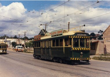
Colour postcard size print of SEC Bendigo trams 2 and 17 at the California or Thorne St. Loop on the Eaglehawk line. Photo dated 21.11.1962. Printed on AGFA paper. Both trams fitted with dash canopy lighting, but no large white strip under the driver's windows. 17 showing destination of "Eaglehawk", has two SEC ads on the side re Electric Cooking . Tram 2 showing destination of "Quarry Hill", has various ads. On rear top left hand corner "21.11.62" in very wavy handwriting typical of an aged person.bendigo, eaglehawk, tram 2, tram 17 -
 Ballarat Tramway Museum
Slide - 35mm slide/s, Travis Jeffrey, late 1960's or early 1970's
Agfa plastic mount (blue base, white cover) with a photo of Bendigo Nos. 3 and 26 at Charing Cross. The trams are bound for Eaglehawk, Quarry Hill respectively. Photo shows the traffic arrangements at Charing Cross prior to closure. Photo taken late 1960's early 1970's from the window of another tram. No. 3 has two roof advertisement racks which are empty, while No. 26 has a SEC briquettes roof advertisement."BES 48" in pencil.tramways, trams, bendigo, charing cross, tram 3, tram 26 -
 Ballarat Tramway Museum
Slide - 35mm slide/s - set of 2, Eldon Hogan?, late 1950's
Set of two Agfacolor cardboard mounted slides - have handwritten captions and two numbers - no date, pre dash canopy stripes and additional lights, late 1950's? Scanned on the Canon scanner at the depot 15/12/1971 at the time of the installation of the scanner. .1 - Bendigo 13, outbound in Pall Mall with the Shamrock Hotel in the background. .2 - Bendigo 2, in bound from Eaglehawk in a very rural situation, unsealed road sides, with the Destination of Quarry Hill..1 - "Tram No. 13 in Pall Mall Bendigo / 24)" in red ink. .2 - "Tram No. 2 approaching Bendigo / 25)" in red ink.tramways, trams, bendigo, eaglehawk, pall mall, tram 13, tram 2 -
 Ballarat Tramway Museum
Photograph - Black & White Photograph/s, Wal Jack, 7/10/1939 12:00:00 AM
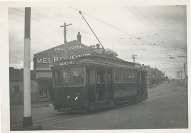
Black and White print contained within the Wal Jack Bendigo and Geelong Album, see Reg Item 5003 for more details. Photo of No. 2 at the Eaglehawk terminus, 7-10-1939, High St, with the Park Hotel in the background. Photo by Wal Jack. Tram has the destination of Quarry Hill. Printed on Ilford paper. i1 - scan of print in the album i2 - rear of image i3 - scan of negative at 3200dpi added 7/6/2020. On the rear in blue ink "SEC Bendigo No 2 (ex MMTB 115 M class) in High St Eaglehawk (terminus) 7th Oct. 1939." with Wal Jack copyright stamp in the top right hand corner and the number "T194" written in.trams, tramways, bendigo, high st, eaglehawk, tram 2 -
 Ballarat Tramway Museum
Slide - 35mm slide/s, early 1960's
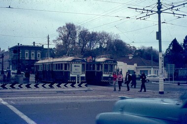
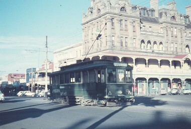
Bendigo Charing Cross, looking east towards railway station, with SEC No. 7 about to depart for Eaglehawk. A Birney tram in background heading for Quarry Hill. Photo shows 'Ezywalkin' and 'Fountain Plaza' buildings, has large white with black lettering road signs on left. On centre pole in front of tram is smaller road direction signs (yellow with black letters) for Echuca, Heathcote and Melbourne. Tram has dash canopy lights, early 1960's.niltramways, trams, bendigo, charing cross, quarry hill, eaglehawk, tram 7 -
 Bendigo Historical Society Inc.
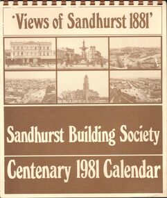
Document - SANDHURST BUILDING SOCIETY CENTENARY 1981 CALENDAR
Buff Paper, Sepia Text & Illustrations 7 Pages Views of Sandhurst 1881 Calendar Images: Beehive Chambers and Mining Exchange Hotel, Pall Mall; panorama from Post Office Tower looking north to White Hills; Sandhurst Post Office Pall Mall; Sandhurst Railway Station (opened 1862) and Quarry Hill;Alexandra Fountain, Charing Cross, (opened 1881); panorama from Post Office Tower looking south to Golden Square.bendigo, history, sandhurst building society calendar -
 Orbost & District Historical Society
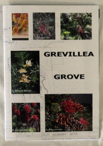
Book, Grevillea Grove, 2017
This book was compiled and published in 2017. The contents are based on a scrapbook and photographs compiled by Margaret Kleinitz who was Secretary of the Orbost Garden Club during the time when Grevillea Grove was proposed and developed from1979-1989. The development of this garden in a disused quarry in Orbost involved a substantial community campaign and on-going effort, particularly from members of the Garden Club. The demise of Grevillea Grove came when the Vic. Govt. decided to develop this parcel of crown land for a Rainforest Garden and Information Centre. Local resident, Audrey Van Den Berg has compiled this book. Shows the effort and dedication involved in this community project.A 40 page book with cardboard cover. Front cover has 6 colour photos of Grevillea plants overlaid onto a plan of the Grevillea Grove garden. This book contains b/w photographs and a written history of the creation of the Grevillea Grove garden in Orbost. It also has site plans and newspaper articles.GREVILLEA GROVE grevillea grove, orbost -
 Bendigo Historical Society Inc.
Administrative record - Bendigo Tailings Company N.L Double Ledger, 1912 - 1913
'A communication from Mr. A.T. Balaam asking that the Central Board of Health be communicated with on the subject of arsenical fumes from the furnaces of the Bendigo Tailings Company at Quarry Hill, where pyrites are to be treated, was also referred to the Mayor.' Bendigo Independent, City Council, p9. 31st May 1913. 'Tenders are invited by the Bendigo Tailings Company for the purchase of two complete cyanide plants, first class assay plants, stores and equipment. Full details may be obtained from the Manager, Mr. J.J. Stanistreet.' Bendigo Independent, p4, 3rd March. 1916.Dark green hard dover book, maroon binding on spine. One hundred and sixty six pages of which ninety three are used. On front cover, white label with 'Double Ledger' printed in black. On front page, a purple stamp: ' Bendigo Tailings Company, No Liability' Alphabetical index in front of book detailing names and pages of transactions. Example for 'L' entry: lease rents; Langdon S.J.; Lansell G.V., L.N. and E; land. Entries in book date from 1912 - 1913. Ledger forms part of the Margaret Roberts Collection of Mining records.bendigo, margaret roberts, , goldmining, bendigo tailings co. n.l., mccoll rankin and stanistreet, arsenic -
Bendigo Historical Society Inc.
Document - MINING REPORTS - LONDONDERRY SHAFT NO 249
' The old Londonderry Mine shaft has been capped after it opened in late July. The shaft was part of the Garden Gully Line, which held the greatest concentration of workings on the Bendigo Goldfield, has been capped after it opened in late July. The line starts under the Quarry Hill Golf Course and continues right through to Eaglehawk North'. (Source: Bendigo Advertiser, August 19, 2014.) Mine was located on Creek Street North, Bendigo. Central Deborah - Heritage Victoria Notes: Originally the Londonderry West shaft, now a mining museumHandwritten extracts by Albert Richardson (with typed copy of same) on the Londonderry Shaft, Bendigo in 1905, with reference to the brick dam being constructed.gold, mining reports, mining reports, londonderry shaft no 249, w westhead -
 Bendigo Historical Society Inc.
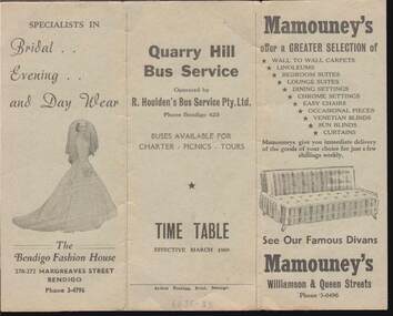
Document - W. BABIDGE COLLECTION: WHERE TO SHOP IN BENDIGO AND SUBURBS
Pale green three fold card with the names, addresses, phone numbers, and goods which can be purchased at the businesses. Businesses named are: Fletchers International Food Store, T. Chamberlin, Northern Terrazzo Co, Suttons Pty. Ltd., Bus Time Table, Ashmans, Reg. V. Brock, Gillies Bros., Miller Bros., The Bendigo Fashion House, Quarry Hill Bus Service, Mamouney's. Printed by Arthur Hocking, Print, Bendigo. Bus Time Table effective March 1960.commerce, advertising, w. babidge collection - where to shop in bendigo and suburbs, fletchers international food store, t. chamberlin, northern terrazzo co, suttons pty. ltd., bus time table, ashmans, reg. v. brock, gillies bros., miller bros., the bendigo fashion house, quarry hill bus service, mamouney's. arthur hocking, print, bendigo, . -
Bendigo Historical Society Inc.
Map - CAMPBELL COLLECTION: BENDIGO AND DISTRICT MAPS, 1982
Map. Forest Commission Victoria, Bendigo Forest District, Greater Bendigo Area. Shire of Marong, Sailors Gully, Epsom, Borough of Eaglehawk, Jackass Flat, White Hills, California Gully, Shire of Huntly, Maiden Gully, Long Gully, North Bendigo, Bendigo East, City of Bendigo, West Bendigo, Kennington, Shire of Strathfieldsaye, Flora Hill, Quarry Hill, Golden Square, Kangaroo Flat, Spring Gully. Prevention Strategy Plan. Base prepared 1982.map, bendigo, forest district