Showing 8789 items
matching south road
-
 Lakes Entrance Regional Historical Society (operating as Lakes Entrance History Centre & Museum)
Photograph, 1990
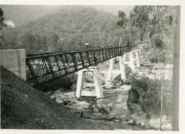
... the Victorian / NSW border, south side of bridge, road to Deddick just..., East Gippsland near the Victorian / NSW border, south side ...Also another photo taken laterColour photograph showing McKillops Bridge across the Snowy River in the High Country near Deddick, East Gippsland near the Victorian / NSW border, south side of bridge, road to Deddick just visible opposite end, taken from west end of bridge. River flowing to right, bridge of timber, steel and concrete, mountains around. East Gippsland Victoriabridges, accommodation, waterways, transport -
 St Kilda Historical Society
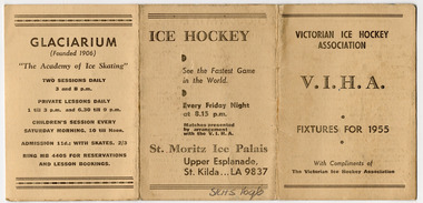
Ephemera - Program, V.I.H.A. Fixtures for 1955, 1955
... (also known as the Glaci), City Road South Melbourne. The St... (also known as the Glaci), City Road South Melbourne. The St ...Victorian Ice Hockey Association fixtures for 1955 at St Moritz Ice Palais, Upper Esplanade St Kilda, and the Glaciarium (also known as the Glaci), City Road South Melbourne. The St. Moritz Ice-skating Palais (its original name) opened in 1939 and operated until 1981. The building was damaged by fire and demolished soon afterwards. The Glaci opened in 1906, at which time it was the 3rd largest indoor ice rink in the world. It hosted the first game of ice hockey played in Australia. It closed in 1957 and the building was destroyed by fire in 1963. Buff coloured card, folded into three, printed in black on both sidesst moritz, glaciarium, ice hockey, victorian ice hockey association -
 Ringwood and District Historical Society
Flyer, Stillwell & Stephens Pty. Ltd, Brochure - Multiple Properties for Public Auction at Box Hill, Ringwood, Wonga Park and Clarinda - 28th November, 1934
... inches South of Bedford Road - timber attic residence. 4..., 150 feet 3 inches South of Bedford Road - timber attic ...Seven-page brochure advertising Mortgagees' Realising Sale by Public Auction on Wednesday, 28th November, 1934 for properties at Box Hill, Ringwood, Wonga Park, and Clarinda (via Oakleigh), including photographs, property descriptions, and terms of sale.Auction Commencing at 2.15 p.m. in the Orient Line Auction Rooms, 352 Collins Street, Melbourne. Solicitors: Messrs. Madden, Butler, Elder & Graham, 406 Collins Street, Melbourne. (Agents) H.P. Knight & Co. Property Salesmen and Subidivisional Experts, 315 Collins Street, Melbourne, 'Phones: Central 10615, 10616. Attractive Residential, Orchard, and Market Garden Properties, and Public Hall and School Rooms. 1. Wonga Park via Ringwood - "Holme Bush" off Warrandyte Road, Part of Lots 14 and 15, Ringwood Orchard Estate, approximatgely three miles (north) of Ringwood Railway Station - 64 Acres. 2. 17 Bishop Street, Box Hill - timber residence. 3. Greenwood Avenue, Ringwood - On East Side, 150 feet 3 inches South of Bedford Road - timber attic residence. 4. Ringwood - Wantirna Road, South-east corner of Canterbury Road - Orchard Property of approx. 11-1/2 Acres. 5. Box Hill - Whitehorse Road, South-east corner of Linsley Street - Timber building utilised as a Public Hall and Private School. 6. Clarinda vic Oakleigh, Talbot Crescent, off Centre Road - Home on 10 acres of land. -
 Kew Historical Society Inc
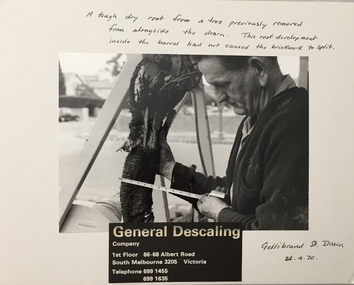
Photograph - Public Works Street Maintenance, Gellibrand Street, General Descaling, 1970
... Descaling / Company / 1st Floor 66-68 Albert Road/ South Melbourne...-68 Albert Road/ South Melbourne 3205 Victoria / Telephone 699 ...The series from which the photograph is drawn provides a snapshot by a commercial photographic studio of specific street works in Kew as well as providing examples of public works infrastructure being commissioned by local government in the 1970s. The photos originally formed part of the Engineering Department's files in the City of Kew before being donated to the Kew Historical Society.In addition to its historic importance as a record of a particular streetscape in Kew in 1970, the photograph also provides an historic record of public works by local government during the period.Public Works Street Maintenance, Gellibrand Street, Kew, Company supplied photograph of measuring a tree root in Gellibrand Street. Inscribed above photo: "A tough dry root from a tree previously removed from alongside the drain. The root development inside the barrel had not caused the brick work to split. Gellibrand St. Drain 24.4.70." Company information: "General Descaling / Company / 1st Floor 66-68 Albert Road/ South Melbourne 3205 Victoria / Telephone 699 1455 / 699 1635."general descaling, drains, gellibrand street (kew) -
 Glen Eira Historical Society
Article - Trinity Congregational Church, Glen Huntly
... building came from, its features and how the land in Grange Road... South Melbourne to Grange Road; it was re-erected a porch ...History of Trinity Congregational Church, Glen Huntly by J. O’ Donnell dated April 1973. Article tells where the church building came from, its features and how the land in Grange Road was obtained. How, after its removal from South Melbourne to Grange Road; it was re-erected a porch and timber cross were added. Source is Caulfield Historical Society Newsletter.trinity congregational church, gothic architecture, market gardens, primitive methodists, gables, glen huntly, grange road, towers, gas lighting, mercy g., porches, congregational union., rosstown sugarmill -
 Melbourne Tram Museum
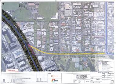
Drawing - Set of 5, Melbourne Metrorail, "Melbourne Metro St Kilda Road - early works", 10/2016
... the relocation of Domain Interchange, Domain Road and Park St South Yarra... the relocation of Domain Interchange, Domain Road and Park St South Yarra ...Drawings prepared by the Melbourne Metro project to show the relocation of Domain Interchange, Domain Road and Park St South Yarra to Toorak Road West and St Kilda Road. Drawings prepared for a Heritage Victoria application dated 26/10/2016. Shows the various work stages principally at the site of Domain Junction where the tram tracks had to be relocated to facilitate the construction of Anzac station.Yields information about the relocation of Domain Interchange to facilitate the construction of the Melbourne Metro.Set of five laminated A3 colour prints with a punch hole in the top left hand corner.metro tunnel, domain interchange, domain road, toorak road, st kilda road, heritage victoria, anzac station -
 Melbourne Tram Museum
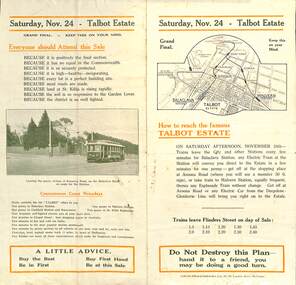
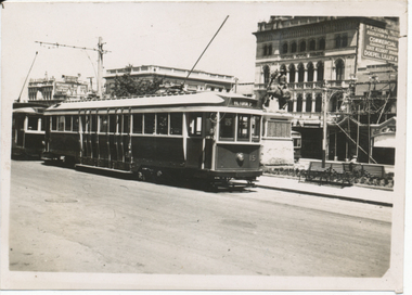
Ephemera - Real estate sale, Forrester & Co, "Talbot Estate" Balaclava, Nov. 1917
... on the south side of Balaclava Road, Balaclava on Saturday 24 Nov. 1917... on the south side of Balaclava Road, Balaclava on Saturday 24 Nov. 1917 ...Pamphlet advertising the sale of land at the Talbot Estate on the south side of Balaclava Road, Balaclava on Saturday 24 Nov. 1917. Promotes the train service from Flinders St, tram service, St Kilda Esplanade, tram services including a photo of PMTT No. 61 at the intersection of Kooyong Road and Balaclava Road. Gives details of the tram fares, agents, solicitors, terms of sale, roads and water supplies.Demonstrates the style of land sale pamphlet including the availability of tram services to prospective purchasers.Pamphlet - folded - printed in two colours of cream coloured paper with photographs.sale of land, trams, balaclava, balaclava road, real estate, talbot estate -
 Whitehorse Historical Society Inc.
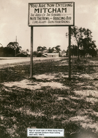
Photograph, Whitehorse Road Sign, C1940s
... 2 copies of sign on south side of Whitehorse Road opposite... dunlavin road 2 copies of sign on south side of Whitehorse Road ...2 copies of sign on south side of Whitehorse Road opposite Dunlavin Road, Mitcham, looking east. Early 1940s. Note in 1870 the area was known as Air Hill. (See also NP941) Center of shot shows shop on west side of what later became Alexander Street and further east house on the corner of Peel Street.These signs are very similar to those erected in nearby Vermontadvertising signs, whitehorse road, mitcham, dunlavin road -
 Eltham District Historical Society Inc
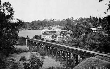
Negative - Photograph, Tom Prior, Railway Trestle Bridge over the Diamond Creek, Eltham, Vic, c.1910
... south along Main Road (near Wingrove Cottage) to be more central... south along Main Road (near Wingrove Cottage) to be more central ...Railway Trestle Bridge over the Diamond Creek, Eltham, c.1910 - looking towards Main Road (left to right) and Henry Street (centre). Built in 1901, the railway line was electrified in 1923. Photo was taken prior to 1912 and the relocation of the new St Mary’s Catholic Church on Henry Street near Main Road (or Maria Street). The church site was relocated c.1912 from further south along Main Road (near Wingrove Cottage) to be more central to the congregation following the shifting of the township away from Little Eltham and closer to the railway station. It was subsequently destroyed by fire in 1961.This photo forms part of a collection of photographs gathered by the Shire of Eltham for their centenary project book,"Pioneers and Painters: 100 years of the Shire of Eltham" by Alan Marshall (1971). The collection of over 500 images is held in partnership between Eltham District Historical Society and Yarra Plenty Regional Library (Eltham Library) and is now formally known as the 'The Shire of Eltham Pioneers Photograph Collection.' It is significant in being the first community sourced collection representing the places and people of the Shire's first one hundred years. The Reynolds family were early settlers in Research. The Reynolds/ Prior collection of photographs were taken by Tom Prior, the maternal uncle of Ivy Reynolds, around 1900 and the 60 photos in the album give a fine overview of many of the landmarks of Research and Eltham over 100 years ago. lvy lived in the family home for many years at 106 Thompson Cres Research. Ivy's father, Ernst Richard Reynolds and grandfather, Richard Reynolds, lived at the same address. Ivy's father Richard worked for Mr. Trail on his property in Research. Reynolds Road is named after the family. Mr Tom Prior (wife Eva) worked at the Melbourne zoo. He was very innovative and made his own camera, using the black cloth hood to exclude the light. The photographs are a reminder of the rural nature of Research and Eltham and its rich heritage.Digital image 4 x 5 inch B&W Negshire of eltham pioneers photograph collection, bridge, diamond creek (creek), eltham, eltham railway trestle bridge, henry street, main road, reynolds prior collection, trestle bridge -
 Eltham District Historical Society Inc
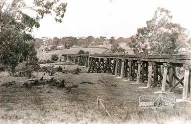
Photograph, Rural view of trestle Bridge, Eltham, c.1912
... been relocated from further south along Main Road (near... been relocated from further south along Main Road (near ...The railway was commenced in 1900 and passed through the middle of the Shillinglaw farm. The line to Eltham opened in 1902. This view shows the the new Catholic Church, St Mary's in Henry Street (near Main Road, then Maria Street) and Shillinglaw Cottage visible in background past where Eltham Town Park and later the Eltham library (1994) was built. The church site had been relocated from further south along Main Road (near Wingrove Cottage) in order to be more central to the congregation following the shifting of the township away from Little Eltham and closer to the railway station. It was subsequently destroyed by fire in 1961.Black and white photographeltham, trestle bridge, bridges, catholic church, henry street, bridge, shillinglaw cottage, shillinglaw trees, shillinglaw farm -
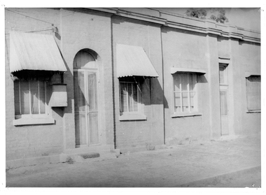 Tarnagulla History Archive
Photograph of Masonic Lodge, Tarnagulla, Masonic Lodge, Tarnagulla, Late 1960s
... : This building still stands at the south end of Commercial Road... at the south end of Commercial Road, Tarnagulla. Originally used ...Murray Comrie Collection. Information from Murray Comrie: This building still stands at the south end of Commercial Road, Tarnagulla. Originally used as the Masonic Lodge Temple of Tarnagulla United Lodge, No. 1318 (E.C.), opened and consecrated 21.1.1869 by Wor. Bro. Wardlow. Br. Stamp was installed as Master. The other part of the building housed the Masonic Hall Hotel, with F.H. Goldsboro as licensee. In later years, this building was known as Bool's (after the Bool family).Monochrome photograph depicting the facade of a building with window canopies and an arched doorway. tarnagulla, buildings, masons, freemasons, freemasonry, lodge, commercial road, bool, stamp, wardlow, goldsboro, hotels -
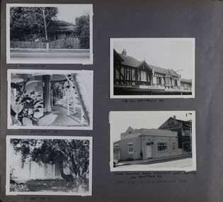 Glen Eira Historical Society
Album - Album page, Hawthorn Road, Circa 1972
... HAWTHORN RD / WEST SIDE - SOUTH OFF BALACLAVA ROAD [under bottom... / WEST SIDE - SOUTH OFF BALACLAVA ROAD [under bottom right photo ...This photograph is part of the Caulfield Historical Album 1972. This album was created in approximately 1972 as part of a project by the Caulfield Historical Society to assist in identifying buildings worthy of preservation. The album is related to a Survey the Caulfield Historical Society developed in collaboration with the National Trust of Australia (Victoria) and Caulfield City Council to identify historic buildings within the City of Caulfield that warranted the protection of a National Trust Classification. Principal photographer thought to be Trevor Hart, member of Caulfield Historical Society. Most photographs were taken between 1966-1972 with a small number of photographs being older and from unknown sources. All photographs are black and white except where stated, with 386 photographs over 198 pages. 17 Hawthorn Road, North Caulfield is a contributory building to HO14 Caulfield North and environs, Caulfield North - Heritage Precinct in the City of Glen Eira.Page 83 of Photograph Album with five portrait photographs of 3 different properties on Hawthorn Road. Addresses are handwritten underneath each property.Handwritten: 17 HAWTHORN ROAD [under top left photo] / 17 HAWTHORN ROAD [under middle left photo] / 17 HAWTHORN ROAD [under bottom left photo] / 158-162 HAWTHORN ROAD [under top right photo] // STATE SAVINGS BANK CAULFIELD WEST BRANCH / 144 HAWTHORN RD / WEST SIDE - SOUTH OFF BALACLAVA ROAD [under bottom right photo] / 83 [bottom left] trevor hart, caulfield, hawthorn road, verandahs, houses, shops, banks, state savings bank, caulfield west, caulfield north, tudor style, victorian style -
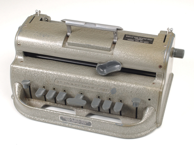 Vision Australia
Machine - Object, Perkins School for the Blind, Perkins Brailler, 1950-1980
... Commercial Road, South Yarra 3141 Phone: (03) 267 6022." Metal plate... 31-51 Commercial Road, South Yarra 3141 Phone: (03) 267 6022 ...Wanting to improve upon the limitations of existing Braillers, the Perkins School for the Blind resolved to develop a new machine that would produce uniformity in embossing, was lightweight and was easy to use. By the 1940's, David Abrahams (a teacher at the school) had developed his prototype, but manufacturing restrictions created by World War 2 halted proceedings. In the waiting period, students at the school used the prototype and Abrahams perfected his device. During the post-war era, Howe Press agreed to take on production of the Perkins Brailler and it became of the most popular and commonly used Braillers around the world since it's commercial release in 1951. Also included is a booklet of photocopied instructions with honeycomb binding.Metal Braille writer with nine grey keys, carriage return key and paper rollers on either side, with grey vinyl cover, and photocopied instruction booklet.'Perkins Brailler' embossed on front of machine and in silver on cover. Sticker on top of machine reads "This equipment remains the property of Braille and Talking Book Library 31-51 Commercial Road, South Yarra 3141 Phone: (03) 267 6022." Metal plate attached to front below keys "Designed by David Abraham, Manufactured and Distributed by Howe Memorial Press, Perkins School for the Blind, Watertown, Mass. U.S.A." Stamped on base of front: G0345braille equipment, perkins school for the blind -
 Eltham District Historical Society Inc
Photograph - Aerial Photograph, Landata, Eltham, Vic, Jan. 1951
... , Dudley Street to south, Zig Zag Road to east and St Helena Road..., Dudley Street to south, Zig Zag Road to east and St Helena Road ...Centred on Allison Crecent Reserve, Sherbrook Road and Scenic Crescent, Eltham bounded by Allendale Road to north, Dudley Street to south, Zig Zag Road to east and St Helena Road to west. Historic Aerial Imagery Source: Landata.vic.gov.au Aerial Photo Details: Project No :65 Project : MELBOURNE AND METROPOLITAN PROJECT NO. 2 Run : 7 Frame : 10 Date : 01/1951 Film Type : B/W Camera : EAG9 Flying Height : 12200 Scale : 12000 Film Number : 1419 GDA2020 : 37°42'14"S, 145°08'36"E MGA2020 : 336339, 5825416 (55) Melways : 21 H2 (ed. 42)Historical aerial photos and photo maps provide viusal evidence of the chronology of changes to the built landscape of the district and assist in dating other imagesaerial photo, 1951-01, eltham, neil webster collection, allendale road, allison crecent reserve, dudley street, melway 21h2, scenic crescent, sherbrook road, st helena road, zig zag road -
Vision Australia
Text, Victorian Association of Braille Writers twenty-fourth annual report 1917-18, 1918
... of the property in Commercial Road South Yarra with the aim of developing... of the property in Commercial Road South Yarra with the aim of developing ...Annual report of the Victorian Braille Writers Association. Articles in the annual report include: List of VABW Patrons president, vice presidents, treasurer, librarian, auditors, committee, book selecting committee and life Governors. Report from the 24th AGM, plus a call for donations and subscriptions from Members and the Public. List of work (number of volumes) done by transcribers to end of March, 1918. This year saw the purchase of the property in Commercial Road South Yarra with the aim of developing a purpose-built library. The money to purchase the property was donated by the Edward Wilson Trust. The last page of the report features a poem entitled "Just Give Them a Chance", composed by a blind child in America. 24 pagesvictorian association of braille writers -
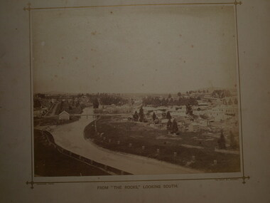 Clunes Museum
Photograph - PHOTOGRAPH LOOK OUT
... THE ROCKS (THE LOOK OUT) ON SCENIC ROAD LOOKING SOUTH. BUTTER...) ON SCENIC ROAD LOOKING SOUTH. BUTTER FACTORY BRIDGE, GOVERNMENT ....1 SEPIA PHOTOGRAPH MOUNTED ON BOARD, TAKEN FROM THE ROCKS (THE LOOK OUT) ON SCENIC ROAD LOOKING SOUTH. BUTTER FACTORY BRIDGE, GOVERNMENT BRIDGE OVER CRESWICK CREEK, BUTTER FACTORY BUILDING, LIGAR STREET TO THE LEFT, FRASER STREET TO THE RIGHT OF PHOTOGRAPH WITH CLUB HOTEL ETC. IN BACKGROUND - SMALL TREES IN WOODEN GUARDS ALONG CREEK. .2 SEPIA PHOTOGRAPH AS ABOVE WITH NOTES WRITTEN ON BORDER POINTING OUT PLACES OF INTERESTphotography, township and bridges, look out scenic road -
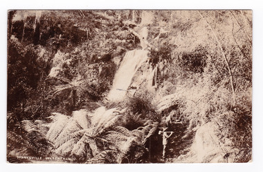 Marysville & District Historical Society
Postcard (item) - Black and white postcard, Marysville Waterfall, 1900's
... / 15 Ealing Road/ South Ealing/ London Date Stamp MELBOURNE/ PM... Road/ South Ealing/ London Date Stamp MELBOURNE/ PM/ 2.15 ...An early black and white photograph of Steavenson Falls in Marysville in Victoria.An early black and white photograph of Steavenson Falls in Marysville in Victoria. The Steavenson Falls is named after the Victorian Assistant Commissioner of Roads and Bridges, John Steavenson who arrived in Victoria in the early 1860s.Post Card The Address to be written on this side. This space may be used for Correspondence/ within the Commonwealth at 1d rate./ Foreign, charged ordinary letter rate. May 1st./ Australia/ Many happy returns of the Day/ A.F. Mrs. H. Clutterbuck/ 15 Ealing Road/ South Ealing/ London Date Stamp MELBOURNE/ PM/ 2.15/ 4.4.06 Stamp/ BILL HOPKINS COLLECTION/ 21 KENSINGTON PARK ROAD W11/ NOTTING HILL GATE LONDONsteavenson falls, marysville, victoria, postcard, souvenir, john steavenson -
Southern Sherbrooke Historical Society Inc.
Information folder - Belgrave Heights Convention Ground
... & South -map "Belgrave Heights Road Map" showing Convention... District Road Map" showing locations in Belgrave Heights & South ...Information folder containing items pertaining to the history of the Belgrave Heights Convention Grounds. Contents: -map, "Belgrave District Road Map" showing locations in Belgrave Heights & South -map "Belgrave Heights Road Map" showing Convention Grounds, buildings and other local sites -Various items photocopied on single sheet, inc. token for Gospel Supplies, Belgrave Heights; item re. Rudi Atwood, minister; list of hymns; photo of Main St, Belgrave. -
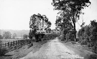 Eltham District Historical Society Inc
Photograph, Tom Prior, Nearing Eltham, from Research, Vic., c.1905, c.1905
... View looking south along the main road from Research... melbourne View looking south along the main road from Research ...View looking south along the main road from Research to Eltham Part of a presentation, "Roads and Byways of the Shire of Eltham", by Russell Yeoman to the 12 September 1990 Society meeting. Slides shown inclyuded copies of old photos and recent images ranging from the suburban streets of Eltham and Montmorency to the mountain roads of Kinglake. In the byways category are views of some iof the Shire's bicycle paths including then recently completed sections of the Main Yarra Trail at Lower Plenty.This photo forms part of a collection of photographs gathered by the Shire of Eltham for their centenary project book,"Pioneers and Painters: 100 years of the Shire of Eltham" by Alan Marshall (1971). The collection of over 500 images is held in partnership between Eltham District Historical Society and Yarra Plenty Regional Library (Eltham Library) and is now formally known as the 'The Shire of Eltham Pioneers Photograph Collection.' It is significant in being the first community sourced collection representing the places and people of the Shire's first one hundred years. The Reynolds family were early settlers in Research. The Reynolds/ Prior collection of photographs were taken by Tom Prior, the maternal uncle of Ivy Reynolds, around 1900 and the 60 photos in the album give a fine overview of many of the landmarks of Research and Eltham over 100 years ago. lvy lived in the family home for many years at 106 Thompson Cres Research. Ivy's father, Ernst Richard Reynolds and grandfather, Richard Reynolds, lived at the same address. Ivy's father Richard worked for Mr. Trail on his property in Research. Reynolds Road is named after the family. Mr Tom Prior (wife Eva) worked at the Melbourne zoo. He was very innovative and made his own camera, using the black cloth hood to exclude the light. The photographs are a reminder of the rural nature of Research and Eltham and its rich heritage.Digital image (Neg missing)shire of eltham pioneers photograph collection, eltham, main road, research (vic.), reynolds prior collection -
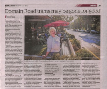 Melbourne Tram Museum
Newspaper - Newspaper clipping, The Age Newspaper, Domain Road trams may be gone for good, 26-03-2023
... south along St Kilda Road and tuns eastward along Toorak Road....Melbourne Tram Museum 8 Wallen Road Hawthorn melbourne ...Article written by the Age transport Reporter, Patrick Hatch. Discusses the possible non-return of trams to Domain Road following the opening of the new tram interchange at ANZAC station. Tram route 8 from Coburg to Toorak was axed when Domain Road closed to St Kilda Road in 2017, and it was combined with route 55 to create a new 58 route. which travels 400 metres further south along St Kilda Road and tuns eastward along Toorak Road.Newspaper clipping from the Age titled: "Domain trams may be gone for good"tramways, trams, route 8, route 58 -
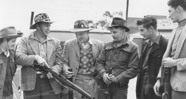 Ringwood and District Historical Society
Photograph, Ringwood Rifle Club. 'Mail' photo, 13/5/1954
... Jumping Creek Road, South Warrandyte. Const. W. Hall, Capt. 2nd.... to proceed to range Jumping Creek Road, South Warrandyte. Const. W ...Black and white photograph (2 copies)Written on back of one copy- "Ringwood Rifle Club. 'Mail' photo, 13/5/1954. L. to R. Vic Beveridge, Constable Bill Hall team captain, Frank Corr, Frank Phillips, Jim Walker and J. Wood". Written on back of second copy- "Ringwood Rifle Club met at corner Main St. and Warrandyte Rd. to proceed to range Jumping Creek Road, South Warrandyte. Const. W. Hall, Capt. 2nd from left." -
 Ballarat Tramway Museum
Photograph - Digital image, Wal Jack, 25/12/1945 12:00:00 AM
... at Sturt St, tramway centre with No. 22 on the south side... St, tramway centre with No. 22 on the south side of the road ...Yields information about the early use of Ballarat's 2nd bogie tram and its first month in service and its use on Christmas Day 1945.Digital image from the Wal Jack Ballarat Album of No. 15 at Sturt St, tramway centre with No. 22 on the south side of the road. Wal notes both cars running on the Victoria Gardens for first time. Has the National Mutual building and South African War Memorial in the background. Taken by Wal Jack on 25-12-1945. See image i2 for rear of photograph. See image i3 for hi res scan of print. See image i4 for hi res scan of negativeIn ink on rear " SEC Ballarat Tramways bogie. 15 ( ex 132) in Sturt St (Tram centre), bogie No. 22 on south side behind South African War Memorial. Both cars running on the Victoria St - Gardens via Sturt St We for first time 25-12-45. " with number "T544" within Wal Jack photo stamp.trams, tramways, sturt st, bogie trams, tram 15, tram 22 -
 Eltham District Historical Society Inc
Slide - Photograph, Second Life, 736 Main Road, Eltham, c.May 1988
... of the section of Main Road south of Henry Street which still has... are key components of the section of Main Road south of Henry ...The c1920 brick shop and side dwelling is one of just three early 20th century shop buildings left in Eltham and one of just two that have intact facades. These shops are physical links with the country village of Eltham at that time and their siting in isolated locations along the street reflects that village era. Since the 1950s Eltham's main street has changed dramatically and the intact pre 1940 buildings such as this shop are key components of the section of Main Road south of Henry Street which still has a streetscape recognisable from that earlier time. The side dwelling illustrates the common practice of that time for shopkeepers to live at their premises. In the 1990s this was an antique Shop and in 2010 “Eltham Cycles”. It is now a popular eatery – Zen Den. 35mm colour positive transparency (1 of 23) Mount - Kodak EktachromeProcess Date MAY 88Meltham, main road, antiques and old wares, cafe zen den, restaurants, second hand dealer, second life decor pty ltd, shops -
 Vision Australia
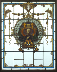
Functional object - Object, Stained glass windows of British authors, 1927
... Library (now Vision Australia Library) in Commercial Road, South... Library (now Vision Australia Library) in Commercial Road, South ...On the 14th May 1927 his Excellency Lord Somers, in the presence of a large assemblage opened Braille Hall at the Braille Library (now Vision Australia Library) in Commercial Road, South Yarra. To mark appreciation of the gift of the hall by the two benefactors Edward Wilson and Richard Gibson, the committee placed two of the stained glass windows on each side of the hall’s fireplace. Commissioned by Librarian Miss Millicent Ritchie, the windows depict four British authors - Scott, Milton, Shakespeare and Dickens. They were removed from South Yarra in 1999 for conservation work and cleaning prior to their relocation to Kooyong in 2001. In 2017 refurbishment works made the windows redundant however they were reinstalled either side of the main entranceway in 2018. 4 x stained glass windows depicting famous writersbraille and talking book library, millicent ritchie -
Glen Eira Historical Society
Map - Gardenvale Road, 11, Caulfield South
... Gardenvale Road, 11, Caulfield South... of the property at 11 Gardenvale Road, Caulfield South. The file also...11 Gardenvale Road, Caulfield South, Victoria, Australia... a valuation of the property at 11 Gardenvale Road, Caulfield South ...A one page typed letter from Equity Trustees to S P Simmonds Estate Agent, dated 12/12/1963, requesting a valuation of the property at 11 Gardenvale Road, Caulfield South. The file also includes a three page typed valuation of the property dated 19/12/1963. It provides details of the property and includes a hand drawn plan (75mm x 100mm) showing measurements of the block. The file also includes one page of undated, unattributed, handwritten working notes for the purpose of the valuation.redapple r r, redapple joseph, redapple rebecca rachel, gardenvale road, caulfield south, land values, brick houses -
 Kiewa Valley Historical Society
Black and white photograph of Surveyor's Camp, 1938, Kiewa River and surveyor's Camp 25/8/38, 25/08/1938
... was an arduous and demanding task. There were no roads beyond Tawonga... accommodation to those men who were surveying the road from South ...Surveying under the prevailing conditions at this time was an arduous and demanding task. There were no roads beyond Tawonga and access was by bridle tracks, on foot or horseback. This camp was to provide accommodation to those men who were surveying the road from South Tawonga to the Bogong High Plains which was commenced in April, 1938. The actual work was undertaken by the Country Roads Board, on behalf of the State Electricity Commission, using three Caterpillar diesel crawler tractors equipped with Kay Bruneriei (Brunner) lhydraulically operated trailbuilders (angle dozers)This photograph shows the primitive living conditions that were endured by those carrying out the initial field investigations and surveys for the Kiewa Hydro Electric Scheme. It is possibly one of the few photographs in existence of this camp and of the very rustic timber foot bridge across the West Kiewa river. It has been taken from approx. 100m up Simmonds Creek Road. A black and white photograph showing a small, timber foot bridge across the West Kiewa River. There is a man standing on the bridge and two small huts on the far side of the river, against a backdrop of Mt. Beauty and Mt. Bogong.At the top of the photograph, handwritten in black ink is the inscription "Kiewa River and Surveyor's Camp 25/8/38". The number 4 is stamped towards the right upper corner. On the back, in a circle, about 1.3cm in diameter, are the words "Kodak Print". The word "Velox" is faintly discernible on the back as well.surveyor, tawonga, west kiewa river, bridge, camp, secv -
 Ringwood and District Historical Society
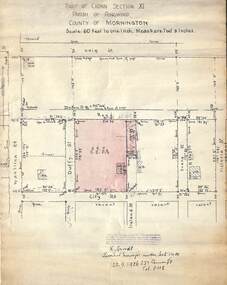
Document, 1926 Land Survey drawing of the area surrounding 1-5 City Road, Ringwood
... was between Haig Street in the north, City Road in the south, Wantirna... Road in the south, Wantirna Road in the west and Victoria Road ...Drawing on parchmentHand-drawn survey of what is now 1-5 City Road, Ringwood. Drawn by K Arndt, licensed surveyor, 237 Queen Street, Melbourne Tel 5118 on 25 September 1926. The block of land in question was 2 roods, 21 and 8/10 perches in size. The location was between Haig Street in the north, City Road in the south, Wantirna Road in the west and Victoria Road in the east. The Good Shepherd Retirement Village (Lutheran) now occupies the land. The drawing shows a number of existing weatherboard houses, fences and frontage sizes. A number of named roads were defined but no longer exist, these were Duffy Street (to the west), Evans Street (east) and Victoria Street (further east). Ireland Street still exists in the south. -
 Ballarat Tramway Museum
Photograph - Black & White Photograph/s, The Courier Ballarat, 30/09/1969 12:00:00 AM
... as Reg. Item 3753. Shows the Albert St road looking south.... Shows the Albert St road looking south. Collected by Alan ...Yields information about Ballarat's tramway system at the point where it crossed Albert St on the Sebastopol route. On of many similar photographs.Black and White copy photograph taken by The Courier, photo not published of No. 42, Albert St (Sebastopol) crossover, looking south. Tram has the destination of Lydiard St Nth, a Briquettes roof advertisement. Presumably photographed 30/9/1969, at the same time as Reg. Item 3753. Shows the Albert St road looking south. Collected by Alan Bradley from the Ballarat Courier early 1980's. See Excel file "Record of Ballarat Courier Photos SEC era" (Archive Documents) for source of details.On rear stamped "Copyright, The Ballarat Courier Proprietary Limited."tramways, trams, albert st, sebastopol, tram 42 -
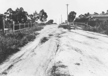 Ringwood and District Historical Society
Photograph, Barkly Street, Ringwood - c1948
... Road. Car probably going south along Wantirna Road. House far... 100 yards down from Wantirna Road. Car probably going south ...Black and white photograph of unmade road in poor condition. Houses in background.Typed below photograph, "Barkly St., Ringwood c.1948". Catalogue card states, "Taken about 100 yards down from Wantirna Road. Car probably going south along Wantirna Road. House far right now block of flats (Sept. 1975) but next two houses up street are there. Haig St. just behind car. Fence on house to left still there and curved front path. Shop visible corner Haig St. to left of big pole still there." -
 Melton City Libraries
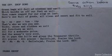
Document, The opp. shop song, Unknown
... Opportunity Shop – Brooklyn Road Melton South Est 1975 Former... Shop – Brooklyn Road Melton South Est 1975 Former Methodist ...SUMMARY – Uniting Church Op Shop Melton South Opportunity Shop – Brooklyn Road Melton South Est 1975 Former Methodist Church. The Opportunity Shop – Established 1975 by Edna Barrie 1992 Typed copy by Cath MacLean 2011 [Scots’ Presbyterian Church 1964] Additional information to the above summarised from Edna Barrie’s draft notes. Copied by Wendy Barrie January 2012, noting the information might be useful for future research. In 1985 the need for more shop space became apparent. Les [Bone] had plans drawn up (Surv 12/8/84) and approved by the Melton shire Council for a storeroom extension (17.800 x 9500) 1986 the small ancillary rooms at the rear of the timber church were demolished allowing the concrete slab to be laid. The building was completed in 1987. By the early 1990s the old timber Church had deteriorated, this lead to it being demolished in 2/11/1993. It was replaced with a new building containing a Pastoral Office, a meeting room and a furniture and homeware section. It was dedicated by Rev Ian Hickingbotham at 11am Sunday 5th June 1994. Service Awards were presented to 75 Opportunity Shop Volunteers by Rev Ian Hickingbotham. Funds have helped to pay for pastoral work, youth work and extra pastoral support. Lyrics for the Opportunity Shop which was located at the former Methodist Church. council, churches, local identities