Showing 1180 items matching "victoria point"
-
 Queenscliffe Maritime Museum
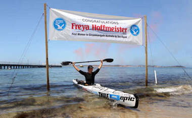
Vehicle - Kayak and Gear
Feja Hoffmeister was the first woman to complete a circumnavigation of Australia by kayak.The journey that started at Queenscliff (Victoria), on the 18/1/2009 and ended at the same point on the 15/12/2009This kayak used by Freja Hoffmeister for her circumnavigation of Australia. Sea kayak [white] with equipment. Various promotional textfreya hoffmeister, kayak, circumnavigation, paul caffyn -
 Queenscliffe Maritime Museum
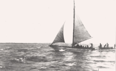
Photograph - B & W photo & newspaper clippings re The THISTLE aground, Black & white photograph of The THISTLE, 10 October 1945
shipwrecks at Corsair Rock VictoriaFishing boat, shipwreckBlack & white photograph of [possibly] The THISTLE lrior to running aground & the newspaper articles about that & the survivor.Reverse - " possibly 'THISTLE' - lost Point Nepean / see Frank Ferrier for details ".historical references -
 Bendigo Historical Society Inc.
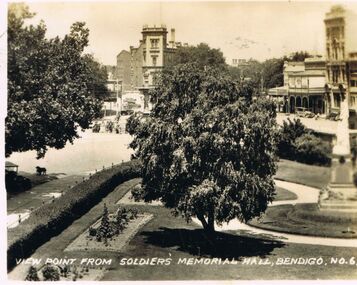
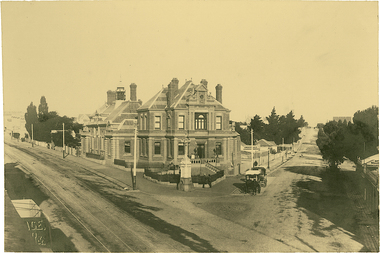
Photograph - LESLIE JOHN BAGUST COLLECTION: VIEW POINT FROM SOLDIERS MEMORIAL HALL, 1940
Leslie John Bagust Collection. Black and White Photograph View Point from R.S.L. Soldiers Memorial Hall, Bendigo 1940. In the foreground Queen Victoria statute and surrounding gardens in the background the City Family Hotel and Cahill's Solicitors on the opposite corner.bendigo, tourism, soldiers memorial halll-view point, http://www.cv.vic.gov.au/organisations/bendigo-rsl-memorial-military-museum/ -
 Bayside Gallery - Bayside City Council Art & Heritage Collection
Map, Department of Crown Lands and Survey et al, Moorabbin, County of Bourke, Government Roads, 1920
The cadastral map of the Parish of Moorabbin in Victoria (L.6104) shows parish boundaries and land ownership 1920 when Sandringham was a Town. The government roads have been coloured in red pencil.moorabbin, county of bourke, map, plan, land subdivision, land titles, foreshores, hampton, beaumaris, highett, cheltenham, department of lands and survey, land owners, cartographic material, brighton, sandringham, town of sandringham, government roads -
 Bayside Gallery - Bayside City Council Art & Heritage Collection
Photograph, Department of Crown Lands and Survey, Victoria, Melbourne Project: Brighton and Elwood, 1976
The Department of Crown Lands and Survey (1857-1983) was responsible for the administration of survey and mapping and the sale, occupation and management of crown land throughout its existence. This aerial photograph shows parts of Brighton and Elwood and was taken on 1 December 1976brighton, elwood, department of crown lands and survey, aerial photograph, elsternwick park, point ormond, north road, ormond esplanade, st kilda street, glen huntly road, bayside, port phillip bay, map, cartographic material, melbourne project 1976 -
 Bayside Gallery - Bayside City Council Art & Heritage Collection
Photograph, Department of Crown Lands and Survey, Victoria, Melbourne Project: Brighton, Hampton, Sandringham, 1976
The Department of Crown Lands and Survey (1857-1983) was responsible for the administration of survey and mapping and the sale, occupation and management of crown land throughout its existence. This aerial photograph shows parts of Brighton, Hampton and Sandringham and was taken on 1 December 1976brighton, department of crown lands and survey, aerial photograph, bayside, port phillip bay, map, cartographic material, hampton, sandringham, green point, sandringham yacht club, south road, beach road, hampton street, melbourne project 1976 -
 Bayside Gallery - Bayside City Council Art & Heritage Collection
Photograph, Department of Crown Lands and Survey, Victoria, Melbourne Project: Brighton and Hampton, 1976
The Department of Crown Lands and Survey (1857-1983) was responsible for the administration of survey and mapping and the sale, occupation and management of crown land throughout its existence. This aerial photograph shows parts of Brighton and Hampton and was taken on 1 December 1976. brighton, department of crown lands and survey, aerial photograph, bayside, port phillip bay, map, cartographic material, melbourne project 1976, brighton yacht club, middle brighton baths, hampton, green point, brighton beach, south road, the esplanade, hampton street -
 Bayside Gallery - Bayside City Council Art & Heritage Collection
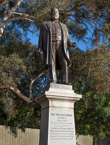
Sculpture, Margaret Baskerville, Sir Thomas Bent, 1913
Arguably Margaret Baskerville’s most famous work, the bronze statue of politician and land speculator Sir Thomas Bent was Baskerville’s first public commission and a significant turning point in her career. Originally located in the centre of the Nepean Highway, in Brighton, it became somewhat of signpost for many Melbournians until it was relocated to the corner of Bay Street in 1980.The statue of Sir Thomas Bent is of historic and social significance to the State of Victoria. The statue is historically significant for commemorating Bent's long, active and infamous political career in Victoria. He was responsible for many important speculative ventures both within his electorate and in the wider context of Victoria. Although not without thought for personal gain, Bent was a committed advocate of public utilities, railways, roads, tramways and gasworks. The statue is historically significant as the first large public commission given to a woman sculptor in Victoria. This work helped the sculptor, Margaret Baskerville, preserve her name as Victoria's first professional woman sculptor. The statue is socially significant as testimony to the late nineteenth century land boom and the financial and political corruption and scandals that accompanied it. https://vhd.heritagecouncil.vic.gov.au/places/12614bronze and granite thomas bent, politician, mayor, premier, bust, sculpture, margaret baskerville, speaker, member of parliament, member of lower house, local government, councillor, brighton, public art, bayside -
 Ballarat Tramway Museum
Negative, Wal Jack, late 1940's or early 1950's
Yields information about the tram services and the Sturt St and Lydiard St intersection and the buildings behind.Negative and Digital image of the Wal Jack Ballarat Negative file of No. 31 turning from Lydiard St into Sturt St with the destination of Victoria St. In the background is the Robbie Burns statue, the inspector observing and holding a point bar. The Mechanics Institute, Beacham's Unicorn Hotel, and Ballarat Built Bicycles and a sign for Holland cycles.trams, tramways, sturt st, tram 31 -
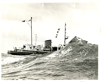 Queenscliffe Maritime Museum
Photograph - Monochrome, MV Wyuna
The ship was built in 1953 by Ferguson Shipbuilders of Port Glasgow, Scotland for the Port Phillip Sea Pilots organisation as a pilot cutter. Her role as a pilot cutter was to sail with pilots on board to meet ships entering Port Phillip Bay. Pilots would be transferred by the Wyuna's workboat to the vessel requiring pilotage while it was stopped dead in the water, with shelter provided by the vessel itself. In the early 1970s the pilot service started using fast launches to allow pilots to board while ships were still underway, and in 1979 the Wyuna was sold to the Australian Maritime College in Launceston, Tasmania as a training vessel. She continued in that role until 2004 when sold to Mineralogy Pty Ltd as an accommodation vessel. In September 2013 she was donated to the Western Port Oberon Association for the Victorian Maritime Centre currently at Crib Point. For a time she was docked at Beauty Point, Tasmania, and after being refurbished for 18 months she was to be moved to Docklands in Melbourne, Victoria. After this berth became unavailable the vessel was docked at Inspection Head Wharf in Beauty Point. After a period there it was towed into Bell Bay where she lays at anchor as of January 2016. When funding becomes available the Western Port Oberon Association has plans to display the vessel in a wet berth alongside the former Royal Australian Navy Oberon-class submarine HMAS Otama.Mr Henry HudsonBlack and white photograph of the Pilot Tender MV Wyuna partially obscured by a large wave at the rip, entrance to Port Phillip Bay.mv wyuna, port phillip pilot service, the rip, the heads, queenscliff, point lonsdale -
 Bendigo Historical Society Inc.
Document - ADDRESS GIVEN AT THE ART GALLERY - BENDIGO
Four pages address given by a member of the committee of the Bendigo Art Gallery detailing the work of the art gallery up to that point in the acquisitions of art works. The speech was given at the presence of the Premier of Victoria Mr. Hamer, the Mayor Cr. Campbell, the councillors of the City of Bendigo, the Mayor of Eaglehawk, dr. Eric Westbrook, Mr. Don Webb and Mr. Dennis Colsey.bendigo, entertainment, art gallery -
 Bendigo Historical Society Inc.
Article - JEWISH SYNAGOGUE JEWISH SETTLEMENT ON THE GOLDFIELDS OF VICTORIA, 1970
JEWISH SYNAGOGUE JEWISH SETTLEMENT ON THE GOLDFIELDS OF VICTORIA Two page article from the Jewish Geneological Society (Vic) Inc. Describes after 1851 was the turning point for settlers in the Port Phillip district. Sub headings: The Jewish life in Ballarat The first synagogue - 1855 A new synagogue for Ballarat - 1859 Eureka Stockade of 1854 Hebrew day School opened in 1870 Jewish population declines Bendigo (formerly known as Sandhurst)buildings, jewish synagogue, jewish synagogue, new synagogue -
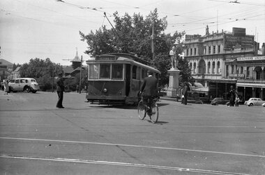
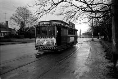 Ballarat Tramway Museum
Photograph - Tram 27 Million Miles - Mal Rowe - 29/6/1968
Photo taken as part of the TMSV tour of the tramway system on a typical Ballarat winters day. Photo in the then disconnected View Point loop in Wendouree Parade. The fence of Ballarat A Power station can be seen in the background. Yields information about the purported achievement of tram 27 reaching 1,000,000 miles and the TMSV Tour. Shows the former View Point crossing loop. This figure was later found to be in error by about 100,000 miles.Digital image of a photograph by Mal Rowe of tram 27 at the former View Point Loop in Wendouree Parade 29/6/1968, during the Tramway Museum Society of Victoria tour to celebrate the tram doing 1,000,000 miles in Ballarat. tmsv, wendouree parade, view point, million miles, tram 27 -
Ballarat Tramway Museum
Sign - Tram Stop Information, State Electricity Commission of Victoria (SECV), Stop Information
Sheet metal signs mounted onto 2 metal brackets top and bottom by rivets. Mounted on wood pole so it faced outwards at right angles. On both faces in black paint on white background is "Trams Leave here for Gardens, View Point, Sebastopol." Believed to be located at the intersection of Sturt St and Drummond St. on the south side before junction.trams, tramways, ballarat, secv, street furniture, tram stops, route signs -
Ballarat Tramway Museum
Sign, State Electricity Commission of Victoria (SECV), "CARS TAKE FOLLOWING LINE"
Galvanised sheet steel with top & bottom holes(central) & side mounting brackets & rounded corners. Painted with black base and white letters and lines used to indicate which depot track(Line) trams were to be parked or stabled on when returning to the depot. Depot had four under cover tracks (1 to 4) and one outside track ("0") road. Lettered as shown on the sketch on the original worksheet. Reg. Item No. 1170.1? shows the object in a wooden frame mounted onto a pole opposite the depot, by depot junction point.trams, tramways, depot, secv, ballarat, tramcar operations, operations -
 Kew Historical Society Inc
Photograph, J F C Farquhar, The Post Office, 1891
At the beginning of the 1890s, the Kew businessman and Town Councillor, Henry Kellett, commissioned J.F.C. Farquhar to photograph scenes of Kew. These scenes included panoramas as well as pastoral scenes. The resulting set of twelve photographs was assembled in an album, Kew Where We Live, from which customers could select images for purchase.The preamble to the album describes that the photographs used the ‘argentic bromide’ process, now more commonly known as the gelatine silver process. This form of dry plate photography allowed for the negatives to be kept for weeks before processing, hence its value in landscape photography. The resulting images were considered to be finely grained and everlasting. Evidence of the success of Henry Kellett’s venture can be seen today, in that some of the photographs are held in national collections.It is believed that the Kew Historical Society’s copy of the Kellett album is unique and that the photographs in the book were the first copies taken from the original plates. It is the first and most important series of images produced about Kew. The individual images have proved essential in identifying buildings and places of heritage value in the district.A panoramic photograph of the junction of High Street and Cotham Road. The photographer centres the point-of-view on the Kew Post Office and adjacent Court House. These were designed in the Queen Anne style by the Public Works Department's architect J Harvey and completed in 1888. The complex is important because it demonstrates a departure from the contemporaneously favoured High Victorian Classical to the Queen Anne style in the design of civic buildings. The earlier Jubilee Fountain in front of the Post Office was erected by the Kew Borough Council to commemorate the Golden Jubilee of Queen Victoria in 1887. It was created to a design of the architects Reed, Henderson and Smart. The fountain was later relocated to the Alexandra Gardens to make way for the Kew War Memorial. The tram tracks in High Street were used by the horse tram, which ran from the Victoria Street Bridge to the Boroondara General Cemetery. The tram was replaced by an electrified service in 1915.The Post Officekew post office, kew illustrated, kew where we live, photographic books, henry kellett -
 Kew Historical Society Inc
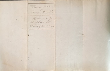
Legal record (Item), Thomas Judd to James Bonwick: Agreement for Sale of Land at Parish of Boroondara, 1853, 28/02/1853
James Bonwick (1817-1906), the Victorian educator and historian, acquired land in Kew on which to establish a home and school in 1853, not 1854 as more commonly stated. Bonwick returned to England in 1859 for a period, later returning to Melbourne and settling in St Kilda. He was the author of a number of histories and an official transcriber of Government records.This newly acquired document, from a former owner of 'Parkhill' (20 Hillcrest Avenue, Kew), is of statewide importance as it is the original copy of the agreement made between Thomas Judd of Parkhill and James Bonwick in 1853 for the purchase of land in Kew. Both Thomas Judd and James Bonwick were significant pioneers of Victoria.TRANSCRIPT [TITLE] Thomas Judd to James Bonwick Agreement for Sale of Land at Parish of Boroondara [PAGE 1] Articles of agreement made and entered into this the Twentyth eighth day of February One thousand Eight Hundred and fifty three Between Thomas Judd of Melbourne in the Colony of Victoria Gentleman of the one part and James Bonwick of Melbourne in the Colony of Victoria Gentleman of the other part whereby the said Thomas Judd agrees to sell unto the said James Bonwick who hereby agrees to purchase a piece or parcel of land containing two and half acres be the land more or less part of Portion Number Eighty five of the Parish of Boroondara in the County of Bourke commencing at a point on the Northern boundary line of the said Portion Seventeen Chains fifty links East from the North West angle of the same and bounded on the East by other part of said Portion in a line bearing South Eight Hundred and sixty two feet on the South by other part of said Portion Eighty five in a line bearing West one Hundred twenty six and half feet on the West by other part of said Portion Eighty five in a line bearing North Eight Hundred and Sixty two feet on the North by the Northern boundary line of the said Portion Eighty five in a line bearing East one Hundred twenty six and half feet to the commencing point at or for the price or sum of one [PAGE 2] One Hundred Pounds to be paid and payable in the manner hereinafter mentioned that is to say the Sum of Thirty pounds to be paid on the day of the date hereof and the sum of forty pounds by the acceptance of the said James Bonwick for that sum at three months bearing interest thereon after the rate of Eight Pounds per centum per annum and the Sum of Thirty pounds by the acceptance of the said James Bonwick for that sum after Six months with interest thereon after the rate of Eight pounds per centum per annum It is furthermore agreed that the said James Bonwick shall have access by a right of way fifteen feet wide reserved by the said Thomas Judd to the Government Road being the Southern Boundary of Portion Eighty five. That in case default shall be made in the payment of any of any of the Acceptances above mentioned the amount paid shall be actually forfeited to the said Thomas Judd who shall be at liberty to resell the premises. That upon payment of the whole amount of the purchase money the said Thomas Judd shall execute a conveyance of the premises to the said James Bonwick Such conveyance to be prepared by and at the expense of the said James Bonwick who - [PAGE 3] who shall also pay the cost of any attested copies he may require. ---- As witness the hands of the said parties this the twenty first day of February one thousand Eight Hundred and fifty Three. ----- [Signature] T. Judd [Signature] Jas Bonwick Witness [Signature illegible] £ Received Cash on account of the above 30.0.0 Thirty Pounds Bill at three Months with interest 42.4.0 Bill at Six Months with interest 31.4.0 _____ £103.8.0 _____ [Signature] T. Judd [Signature] Jas Bonwick ------------ Transcribed David White 25/08/2020 james bonwick, thomas judd, land titles - kew (vic), pioneers - kew - victoria -
 Kew Historical Society Inc
Photograph - Dight's Falls, 1924
Henry Beater Christian (1886-1962) , was a descendant of one of the earliest settler families in Kew. Employed at the Kew Asylum as a 'public servant', he was a skilled amateur photographer, photographing numerous scenes in Kew and on his travels around Victoria. The majority of his photographs date from 1916 to 1929. His finest photographs are housed in two photograph albums. Digital copy of a photograph from page 6 of the 47-page photograph album containing 261 gelatinous silver images, loaned by Diane Washfold with permission given to digitise and hold a copy in our collection. This is a photograph id of the. Yarra River at Dight's Falls. The point of view is from the freshwater section of the river looking across to the cliffs on the Kew side of the river. Standing on the cliffs is a tiny figure of a man. "Yarra Rvr / Kew"henry beater christian (1886-1962), landscape photography, kew (vic.) — yarra river, christian-washfold collection, photograph albums, dight's falls -
 Kew Historical Society Inc
Photograph - Yarra River, Studley Park, 1924
Henry Beater Christian (1886-1962) , was a descendant of one of the earliest settler families in Kew. Employed at the Kew Asylum as a 'public servant', he was a skilled amateur photographer, photographing numerous scenes in Kew and on his travels around Victoria. The majority of his photographs date from 1916 to 1929. His finest photographs are housed in two photograph albums. Digital copy of a photograph from page 9 of the 47-page photograph album containing 261 gelatinous silver images, loaned by Diane Washfold with permission given to digitise and hold a copy in our collection. The point-of-view selected by the photographer, Henry Christian, was the stretch of the Yarra at Studley Park. In selecting this view he concentrates on the tranquility of the river and the remnant vegetation that lines the banks. "Studley Park / Kew"henry beater christian (1886-1962), landscape photography, kew (vic.) — yarra river, christian-washfold collection, photograph albums, yarra river -- studley park (vic.) -
 Kew Historical Society Inc
Photograph - Dight's Falls, 1924
Henry Beater Christian (1886-1962) , was a descendant of one of the earliest settler families in Kew. Employed at the Kew Asylum as a 'public servant', he was a skilled amateur photographer, photographing numerous scenes in Kew and on his travels around Victoria. The majority of his photographs date from 1916 to 1929. His finest photographs are housed in two photograph albums. Digital copy of a photograph from page 9 of the 47-page photograph album containing 261 gelatinous silver images, loaned by Diane Washfold with permission given to digitise and hold a copy in our collection. The point-of-view selected by the photographer, Henry Christian, is of Dight's Falls on the Yarra River from the Kew side. Dight's Falls separates the saline and fresh water sections of the river. "Studley Park / Kew"henry beater christian (1886-1962), landscape photography, kew (vic.) — yarra river, christian-washfold collection, photograph albums, yarra river -- studley park (vic.), dight's falls -
 Kew Historical Society Inc
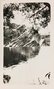
Photograph - Yarra River below Dight's Falls, 1924
Henry Beater Christian (1886-1962) , was a descendant of one of the earliest settler families in Kew. Employed at the Kew Asylum as a 'public servant', he was a skilled amateur photographer, photographing numerous scenes in Kew and on his travels around Victoria. The majority of his photographs date from 1916 to 1929. His finest photographs are housed in two photograph albums. Digital copy of a photograph from page 9 of the 47-page photograph album containing 261 gelatinous silver images, loaned by Diane Washfold with permission given to digitise and hold a copy in our collection. The point-of-view selected by the photographer, Henry Christian, is below Dight's Falls on the Yarra River from the Kew side. Dight's Falls separates the saline and fresh water sections of the river. "Studley Park / Kew"henry beater christian (1886-1962), landscape photography, kew (vic.) — yarra river, christian-washfold collection, photograph albums, yarra river -- studley park (vic.), dight's falls -
 Kew Historical Society Inc
Photograph - Yarra River, Studley Park, 1924
Henry Beater Christian (1886-1962) , was a descendant of one of the earliest settler families in Kew. Employed at the Kew Asylum as a 'public servant', he was a skilled amateur photographer, photographing numerous scenes in Kew and on his travels around Victoria. The majority of his photographs date from 1916 to 1929. His finest photographs are housed in two photograph albums. Digital copy of a photograph from page 9 of the 47-page photograph album containing 261 gelatinous silver images, loaned by Diane Washfold with permission given to digitise and hold a copy in our collection. The point-of-view selected by the photographer, Henry Christian, is from the Yarra River at Dight's Falls looking up at the cliffs at Galatea Point. "Studley Park / Kew"henry beater christian (1886-1962), landscape photography, kew (vic.) — yarra river, christian-washfold collection, photograph albums, yarra river -- studley park (vic.), dight's falls, galatea point -
 Kew Historical Society Inc
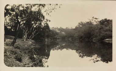
Photograph - Yarra River, Studley Park, 1924
Henry Beater Christian (1886-1962) , was a descendant of one of the earliest settler families in Kew. Employed at the Kew Asylum as a 'public servant', he was a skilled amateur photographer, photographing numerous scenes in Kew and on his travels around Victoria. The majority of his photographs date from 1916 to 1929. His finest photographs are housed in two photograph albums. Digital copy of a photograph from page 9 of the 47-page photograph album containing 261 gelatinous silver images, loaned by Diane Washfold with permission given to digitise and hold a copy in our collection. The point-of-view selected by the photographer, Henry Christian, is of a small section of the Yarra River at Studley Park. The still water and the reflection is the most noticeable aspect that he sought to capture in the image."Studley Park / Kew"henry beater christian (1886-1962), landscape photography, kew (vic.) — yarra river, christian-washfold collection, photograph albums, yarra river -- studley park (vic.) -
 Kew Historical Society Inc
Photograph - Yarra River, Studley Park, 1924
Henry Beater Christian (1886-1962) , was a descendant of one of the earliest settler families in Kew. Employed at the Kew Asylum as a 'public servant', he was a skilled amateur photographer, photographing numerous scenes in Kew and on his travels around Victoria. The majority of his photographs date from 1916 to 1929. His finest photographs are housed in two photograph albums. Digital copy of a photograph from page 9 of the 47-page photograph album containing 261 gelatinous silver images, loaned by Diane Washfold with permission given to digitise and hold a copy in our collection. The point-of-view selected by the photographer, Henry Christian, is of a small section of the Yarra River at Studley Park. The still water and the reflection is the most noticeable aspect that he sought to capture in the image."Studley Park / Kew"henry beater christian (1886-1962), landscape photography, kew (vic.) — yarra river, christian-washfold collection, photograph albums, yarra river -- studley park (vic.) -
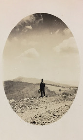 Kew Historical Society Inc
Photograph - Rural landscape, c.1926
Henry Beater Christian (1886-1962) , was a descendant of one of the earliest settler families in Kew. Employed at the Kew Asylum as a 'public servant', he was a skilled amateur photographer, photographing numerous scenes in Kew and on his travels around Victoria. The majority of his photographs date from 1916 to 1929. His finest photographs are housed in two photograph albums. Digital copy of a photograph from page 17 of the 47-page photograph album containing 261 gelatinous silver images, loaned by Diane Washfold with permission given to digitise and hold a copy in our collection. This photograph, dating from c.1926, forms part of a group of photos preceding images of [Black] Spur, so the photographs may have been taken as part of that bushwalking trip. John Chapman has written in 'Bushwalking Clubs - A Brief History', about the establishment in Victoria of the first bushwalking club in 1888, and the popularisation of bushwalking during the interwar period. Henry Christian's 'walks' appear to have been undertaken solely or with a companion/s. This camera shot invites the viewer to access the landscape through the point-of-view of the man standing with his back to the camera at the edge of the road. The man holds leaves in his left hand [to deter insects], and has a knapsack on his back. The landscape in the distance includes both cleared land for farming and remnant vegetation. The oval framing device was used when Henry Christian developed the photo.Illegible ink inscription on pagehenry beater christian (1886-1962), landscape photography, kew (vic.) — yarra river, christian-washfold collection, photograph albums, bushwalking -- victoria -
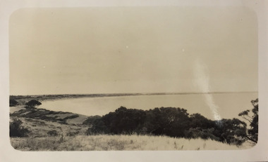
 Kew Historical Society Inc
Photograph - Mouth of the Hopkins River, Point Ritchie, Warrnambool, c.1926
Henry Beater Christian (1886-1962) , was a descendant of one of the earliest settler families in Kew. Employed at the Kew Asylum as a 'public servant', he was a skilled amateur photographer, photographing numerous scenes in Kew and on his travels around Victoria. The majority of his photographs date from 1916 to 1929. His finest photographs are housed in two photograph albums. Digital copy of a photograph from page 23 of the 47-page photograph album containing 261 gelatinous silver images, loaned by Diane Washfold with permission given to digitise and hold a copy in our collection. Henry Christian took a number of walking and rail trips, individually or with friends, around regional and rural Victoria during the 1920s. This photo is from a series of twelve photographs of parts of the west coast of Victoria, including Port Fairy and Warrnambool. The location in this photograph has been identified by Kathleen Gervasoni as the mouth of the Hopkins River, Point Ritchie, Warrnambool. henry beater christian (1886-1962), landscape photography, christian-washfold collection, photograph albums, hopkins river, point ritchie, warrnambool -
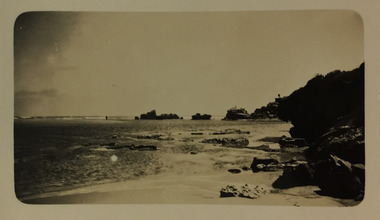
 Kew Historical Society Inc
Photograph - East Beach from Battery Hill, Port Fairy, c.1926
Henry Beater Christian (1886-1962) , was a descendant of one of the earliest settler families in Kew. Employed at the Kew Asylum as a 'public servant', he was a skilled amateur photographer, photographing numerous scenes in Kew and on his travels around Victoria. The majority of his photographs date from 1916 to 1929. His finest photographs are housed in two photograph albums. Digital copy of a photograph from page 23 of the 47-page photograph album containing 261 gelatinous silver images, loaned by Diane Washfold with permission given to digitise and hold a copy in our collection. In the 1920s, the photographer travelled throughout Victoria, including on the west coast from Port Campbell to Port Fairy. Trips were presumably made by train and by foot. Lynda Tieman and her team at the Port Fairy Historical Society have tentatively identified a number of Henry Christian's photographs of Port Fairy, of which this is one. The photo is believed to be of East Beach from Battery Hill.henry beater christian (1886-1962), landscape photography, christian-washfold collection, photograph albums, east beach -- port fairy (vic.), battery point, port fairy -
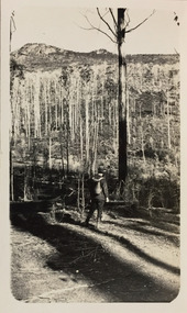 Kew Historical Society Inc
Photograph - Sunnyside and Mt Wills, c.1926
Henry Beater Christian (1886-1962) , was a descendant of one of the earliest settler families in Kew. Employed at the Kew Asylum as a 'public servant', he was a skilled amateur photographer, photographing numerous scenes in Kew and on his travels around Victoria. The majority of his photographs date from 1916 to 1929. His finest photographs are housed in two photograph albums. Digital copy of a photograph from page 35 of the 47-page photograph album containing 261 gelatinous silver images, loaned by Diane Washfold with permission given to digitise and hold a copy in our collection. John Chapman has written in 'Bushwalking Clubs - A Brief History', about the establishment in Victoria of the first bushwalking club in 1888, and the popularisation of bushwalking during the interwar period. Henry Christian's 'walks' appear to have been undertaken solely or with a companion/s. This black and white photo is part of a group of photos taken in the Victorian High Country. The page is labelled 'Mt Wills / Sunnyside' and includes photos of landscapes and built structures. Mt Wills and Sunnyside were at the time goldfields north of Omeo. This small black and white point-of-view photograph shows the photographer, Henry B Christian, staring across a treed landscape to Mt Wills in the distance."MT WILLS / SUNNYSIDE"henry beater christian (1886-1962), landscape photography, christian-washfold collection, photograph albums, bushwalking, northeast victoria, victorian high country, mt wills, sunnyside -
 Kew Historical Society Inc
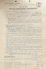
Document, Arnall & Jackson: Printers & Stationers, City of Kew: Air Raid Precautions Organisation, June 1940
Air Raid Precautions Organisations were formed in each State in Australia during the Second World War. In Victoria they were organised by the State Emergency Council (Victoria) for Civil Defence. In Melbourne, the organisations were locally based in municipalities. Within a municipality, areas were organised into sectors.Twelve point instructions distributed by the District Warden's Office, Town Hall, Kew in June 1940 and issued by the authority and with the approval of the Kew City Council, W. D. Birrell (Town Clerk), outlining advice for residents in the event of an air raid. City of Kew seal at top right. The document was issued to residents in Sector 9. It was printed by Arnall & Jackson, 115 Barkly Street, W. Brunswick.Signed [Sector Warden] F. J. [sic] Warry, 65 Molesworth Street; [Senior Warden] K. L. Robertssecond world war, city of kew, wwii, air raid precautions organisation -
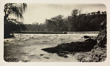
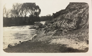
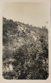
![Cumberland Creek, near Point Sturt / [by] Nicholas Caire, circa 1876](/media/collectors/550653872162f11fb04854aa/items/57834713d0cdd1176c71111b/item-media/57834799d0cdd1176c71e113/item-fit-380x285.jpg) Kew Historical Society Inc
Kew Historical Society IncPhotograph, Anglo-Australasian Photographic Company, Cumberland Creek, near Point Sturt, c. 1876
... ‘Cumberland Creek, near Point Sturt’ : Views of Victoria... no other vegetation can be found.’ ‘Cumberland Creek, near Point ...Nicholas Caire was born on Guernsey in the Channel Islands in 1837. He arrived in Adelaide with his parents in about 1860. In 1867, following photographic journeys in Gippsland, he opened a studio in Adelaide. From 1870 to 1876 he lived and worked in Talbot in Central Victoria. In 1876 he purchased T. F. Chuck's studios in the Royal Arcade Melbourne. In 1885, following the introduction of dry plate photography, he began a series of landscape series, which were commercially successful. As a photographer, he travelled extensively through Victoria, photographing places few of his contemporaries had previously seen. He died in 1918. Reference: Jack Cato, 'Caire, Nicholas John (1837–1918)', Australian Dictionary of Biography.An original, rare photograph from the series 'Views of Victoria: General Series' by the photographer, Nicholas Caire (1837-1918). The 60 photographs that comprise the series were issued c. 1876 and reinforced a neo-Romantic view of the Australian landscape to which a growing nationalist movement would respond. Nicholas Caire was active as a photographer in Australia from 1858 until his death in 1918. His vision of the Australian bush and pioneer life had a counterpart in the works of Henry Lawson and other nationalist poets, authors and painters.‘Cumberland Creek, near Point Sturt’ : Views of Victoria (General Series) No.59 : Albumen silver photograph | Photo on card with Title and Description on reverse | Mounted 24 x 30 cm; Photo 12 x 17 cm.On Reverse: ‘The Cumberland Creek is so named from the close resemblance it bears to the place bearing that name in the mother country. The present illustration represents the precipices and hills which surround the Cumberland Creek. The soil around the hills is mostly sandstone rubble, hence the only vegetation identical with the spot is the inevitable sword grass and salt scrub, which frequently exist where no other vegetation can be found.’nicholas caire (1837-1918), landscape photography