Showing 10818 items
matching plans
-
 Bendigo Historical Society Inc.
Document - MERLE HALL COLLECTION: DOCUMENTS RELATING TO HERITAGE MOSAIC
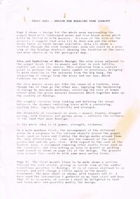
Various documents relating to Heritage Mosaic project Bi-fold A4 flyer : Bendigo Heritage Mosaic - Rosalind Park Lookout includes description, background and illustrative sketch of Mosaic area; List of contacts re possible Mosaic Project 7/3/01 a list of Bendigo facilities contacted and agreed to letters of support; form letter dated 3/8/2001to agencies/organizations re support for submission for series of small mosaic pieces along the Linear Pathway adjacent to the Bendigo Creek; memo to Bernard Smith from Judy MacDonald (BRAC) re plans for Lookout Mosaic (with the attached design details from Maery Hall (3 sheets of sketches and photograph are said to be attached but not now). -
 University of Melbourne, Burnley Campus Archives
Photograph, Ministry for Planning and Environment April 1966. Photographic Archive Project, Museum of Victoria, Display of Early Victorian Gardens, 1996
display, early victorian gardens, garden design, linton district, geelong, stockyard hill, amherst -
 Falls Creek Historical Society
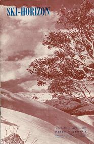
Journal - Ski-Horizon Vol. 2 No 8
Ski-Horizon is the official journal of the Federation of Victorian Ski Clubs which began publication in 1949. The were 26 original member clubs which included Albury Ski Club, Bogong Ski Club, Myrtleford Ski Club, Tallangatta and District Ski Club and Wangaratta Ski Club. Two pioneers of Falls Creek, Tom Mitchell, M.L.A., and Martin Romuld were Vice-Presidents of the Federation.This Journal is significant because it documents the early development of skiing in Victoria.The journal features stories and events chronicling developments in Victoria and internationally. Items related to the Falls Creek Area in this publication include:- Page 2: Toni St Elmo sent a list of Bogong Ski Club members who had passed N.Z. tests during their tour of New Zealand in 1950. Page 10 - 12 An extensive article (Falls Creek", written by Pauline McLean who had spent several holidays there. It includes travel requirements and restrictions and the need to acquire provisions. Reference is made to lodges including the "Skyline" and to Bill Hymans and Ron Roberts' refreshment kiosk at the foot of the tow. Page 13 Toni St Elmo is planning to have a ski tow installed for the coming season. A detailed description of the tow is included.ski history victoria, federation of victorian ski clubs, nedsa events, victorian skiing 1949 -
 Melbourne Tram Museum
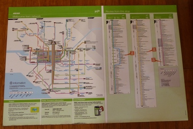
Poster, Yarra Trams, "Melbourne Tram Network" and "Routes from this Stop", Dec. 2012
Full colour poster printed on a vinyl plasticized based sheet, titled "Melbourne Tram Network" - showing a diagrammatic layout of Melbourne tram routes, Myki ticket notes and where tickets can be obtained, information numbers (PTV, phone applications) and information on Tram Tracker, twitter and other contact systems on the left side. On the right side titled "Routes from this Stop" is the information and detailed plan of every stop on routes 3, 3a, 16 and 96, including buses and train stop and connecting tram services. Printed for Stop 136, The Esplanade. Map shown as effective April 2011, printed December 2012. Has the document information on the right hand side of the poster. Two copies held.trams, tramways, yarra trams, ptv, maps, tramtracker, myki, the esplanade, route 96, route 3, route 16 -
 Bendigo Military Museum
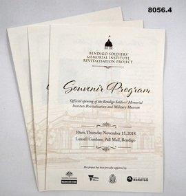
Pamphlet - SOUVENIR PROGRAM, SOLDIERS MEMORIAL INSTITUTE 2018, City of Greater Bendigo, C. Nov 2018
When the SMI was opened in Nov 1921 the Bendigo RSL Sub - Branch had occupancy from that day on. The Building became a Museum opened to the public in 1998 by the RSL. The origins of this project goes back to 2011 with a letter to the City of Greater Bendigo of the possibility of an upgrade to the SMI from the Bendigo District RSL Sub - Branch Inc. Some renovations had already taken place and some structural work. After initial talks a sub - committee of 3 persons from the RSL was elected to work with the Council along with other bodies who would be involved. Plans eventuated by 2015 and were put to the RSL for approval. From there the fund raising began from the State/Federal Govt's, RSL, the Public and Council itself. This was achieved and finally in Sept 2016 the SMI/Museum was packed up completely and the Renovations began in 2017. Souvenir program, card yellow colour folding, front page is in gold and black writing with an image of the Dome on the SMI followed by in gold, "Bendigo Soldiers Memorial Institute Revitalisation Project" then in gold, "Souvenir Program", in the centre has details re time, date, place. At the bottom are the logo's of the Federal & State Governments, RSL and City of Greater Bendigo Page 2 is titled "About the Bendigo Soldiers Memorial Institute" with a photo showing the "Hustlers Royal Reserve Mine No 2" which was on the site where the SMI now stands. Page 3 has details of the program, music, Official welcome, speakers, ribbon cutting, the ODE, Last Post, National Anthem, close of formalities and light refreshments. Page 4 has a photo of the original souvenir pamphlet used at the original opening on November 15th 1921, 97 years to the day. at the bottom, "Thankyou section to all those involved in the project""Official opening of the Bendigo Soldiers Memorial Institute Revitalisation and Military Museum 10am Thursday November 15, 2018, Lansell gardens, Pall, Mall Bendigo"brsl, smirsl, program -
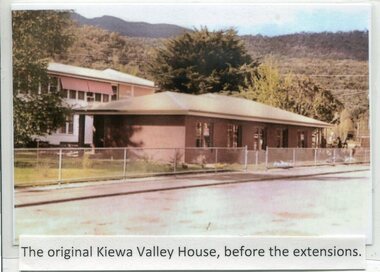 Kiewa Valley Historical Society
Photographs- Kiewa Valley House (before and after extensions) & Tawonga District General Hospital- Set of 6 colour photographs
The establishment of Kiewa Valley House, was a significant victory for residents and senior citizens in the Kiewa Valley district. Plans were laid in the mid 1970’s and a proposal was formulated for a 12 bed unit nursing home to be attached to the Tawonga District General Hospital. The need for an aged care facility in Mount Beauty was prompted by recognition of the high ratio of senior citizens residing in the area. At the time residents had to travel to Beechworth, Wangaratta or Wodonga for care. On June 6th, 1980, an appeal to finance a 12 bed nursing wing was launched at a public meeting in Mount Beauty The Hospital and Charities Commission’s development board finally approved the application for government funds to build the 12 bed nursing home in early 1981. The official opening of the nursing home was on March 6th, 1985. Opening of the lounge extensions occurred in May, 1993 Many local residents have taken advantage of facilities at Kiewa Valley House when they became unable to manage independently in their own homes. This has meant they did not have to face the stress of leaving the area and being separated from their local family and friends. Many SEC workers and their families have been residents of Kiewa Valley House over the years.Set of 6 colour photographs of Kiewa Valley House and original Tawonga District General Hospital in Mt Beauty 1 Kiewa Valley House, before extensions, with old weatherboard hospital in background 2 & 3 Official opening of Kiewa Valley House. 4 & 5 Gardens between Kiewa Valley House and Hospital 5. Kiewa Valley lounge extension 1. The original Kiewa Valley House, before extensions 2. No markings 3. No markings 4. View of the gardens between the weatherboard hospital and Kiewa Valley House 5. Walkway between Hospital & Kiewa Valley House 6. Kiewa Valley House Lounge Room extension tawonga district hospital, kiewa valley house, mt beauty district hospital -
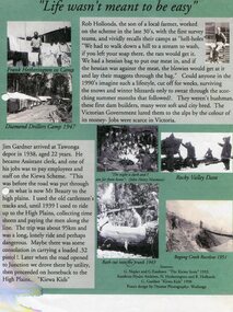 Kiewa Valley Historical Society
Posters – Set of 3 A4 posters depicting the early days and people in the Kiewa Valley
In the 1830’s, European pastoralists started moving south from NSW into the Alps. In 1836, cattle grazing began around Omeo and the runs spread out into the foothills. The higher country was used for summer grazing and huts were built for shelter and storage during stock mustering. The lure of gold brought many people to the Alps from around 1850 to 1900. Bushfires destroyed the forests around Melbourne in 1939 and the boom in house-building after World War II ked to increased demand for timber from the Alps. This resulted in the building of a network of roads which helped open up access to the Alps. The early 1940’s brought the first of many workers to the Alps for the planning and construction of the Hydro-Electric Scheme. These were the pioneers and early settlers of the Kiewa Valley and provided a wealth of characters and a tapestry of stories and adventures to be handed down to future generations.These 3 posters, which were most likely produced for promotional purposes provide a glimpse into the early lives of the pioneer families of the Kiewa Valley through pictures and verse. They show their lifestyle and outline the hardships they had to endure in living and working in the Alpine region. They also highlight the early arguments regarding grazing in the high country which would ultimately lead to the end of the long traditions of the high country cattle men. Set of 3 A4 size posters with black and white photographs and text and colour background depicting various parts of the history of the Kiewa Valley. 1. Titled - ‘Life wasn’t meant to be easy’ Describes early life for Kiewa Hydro workers. 2. Titled - ‘Cattlemen of the High Plains’ Describes a brief history of life of the cattlemen of the high plains 3. Titled – ‘There are Places I’ll remember’ Depicts early photographs of residents of the Kiewa Valley, also includes the words from a John Lennon song as per poster title. Printed on each poster – Poster designed by Dyanne Photography - Wodonga 1. Printed at bottom of poster – Sources: G Napier and G Easdown “The Kiewa Story” 1993. Southern Hydro Archives, N Hetherington and R Hollands. G Gardner “The Kiewa Kids” 1998. 2. Printed at bottom of poster – Sources: D Purland. Handwritten at top of poster- Poster 4 3. Printed at bottom of poster – Sources: B Roper, W Davies, D Higginson, H Ryder. Handwritten at top of poster- Poster 3 kiewa valley; tourism; lifestyles -
 Eltham District Historical Society Inc
Photograph - Digital Photograph, Alan King, Original Kangaroo Ground Primary School No. 2105 building, Eltham-Yarra Glen Road, Kangaroo Ground, 28 December 2007
Kangaroo Ground's first school began in 1851 with 22 pupils from the district's ten families. It was a single room school located further south on the site, which also served as a Presbyterian church. The first teacher was Andrew Ross. The school building was used as a Post Office between 1854 and 1858 and during 1857 also served as a Court of Petty Sessions. With a growing farming community, a new building was warranted and the original Sate School No. 352 was closed and a new building, State School No. 2105 was oipened October 1, 1878. A residence for Head Teacher Henry Wallace School was erected in 1879 attached to the left of the school building. That residence is now home to the Andrew Ross Museum, which opened in 1993. Covered under Heritage Overlay, Nillumbik Planning Scheme. Published: Nillumbik Now and Then / Marguerite Marshall 2008; photographs Alan King with Marguerite Marshall.; p35This collection of almost 130 photos about places and people within the Shire of Nillumbik, an urban and rural municipality in Melbourne's north, contributes to an understanding of the history of the Shire. Published in 2008 immediately prior to the Black Saturday bushfires of February 7, 2009, it documents sites that were impacted, and in some cases destroyed by the fires. It includes photographs taken especially for the publication, creating a unique time capsule representing the Shire in the early 21st century. It remains the most recent comprehenesive publication devoted to the Shire's history connecting local residents to the past. nillumbik now and then (marshall-king) collection, kangaroo ground, eltham-yarra glen road, kangaroo ground primary school no. 2105, kangaroo ground state school, state school no. 2105 -
 Eltham District Historical Society Inc
Photograph, Fay Bridge, EDHS Heritage Excursion, Edendale Farm, 5 May 2018
May Excursion – Edendale Environs Edendale Community Environment Farm in Gastons Road, Eltham now operates as Nillumbik Council’s environmental centre. The historic homestead has undergone a significant restoration and there is on-going development of the site consistent with its community education purpose. The house and the gateway sculpture “The Fences Act” are covered by a Heritage Overlay in the Nillumbik Planning Scheme. Our May excursion will comprise a walk through the farm property and will radiate to other nearby places of historic interest. These will include the site of the Eltham North Adventure Playground to discuss its history and destruction by fire (see page 1 article). Also nearby is Colemans Corner where the early road system has undergone some unusual changes. If time permits we may visit some other nearby places of interest. - EDHS Newsletter No. 239 April 2018fay bridge collection, 2018-05-05, edendale community farm, edendale farm, eltham district historical society, heritage excursion, activities -
Glen Eira Historical Society
Article - Shoobra Road, 2, Elsternwick
Three real estate advertisements and one article about the sale of 2 Shoobra Road on three occasions: 1/Article from Bayside Weekly of July 2009 by Neil Clerehan describing the house’s history and features. Includes one exterior and two interior colour photographs. 2/Advertisement for sale of 2 Shoobra Road in Bayside Weekly of July 2009. It describes house’s features, one exterior colour photograph. 3/Advertisement for sale of 2 Shoobra Road by Auction dated 10/08/2011 in Melbourne Weekly Bayside. Describes house features and includes one colour exterior photograph and plan of the land. 4/Advertisement for sale of 2 Shoobra Road by auction in Melbourne Weekly Bayside dated 06/06/2012. Describes house features and includes one exterior and one interior colour photograph.shoobra road, elsternwick, city of glen eira, city of caulfield, city of moorabbin, elsternwick, glen huntly road, glen huntly railway station, elsternwick railway station, caulfield north, tbm, persichetti leonard, meltzer selwyn, architectural styles, edwardian style, architectural features, gables, verandahs, lead lights, brick houses, biggin scott, crowe amy, stavrakis bill, williams kharla, ceilings, real estate agents -
Glen Eira Historical Society
Letter - St Aloysius Church, Caulfield
A series of correspondence dated between 21/08/1985 to 10/11/1988 regarding the Historic Buildings Council adding St Aloysius Church on Balaclava Road, Caulfield to the Historic Buildings Register. Four of the letters are between the Historic Buildings Council, the Caulfield Historical Society and the City of Caulfield. Copies of the replies by the Historical society (as indicated by handwritten notes in the letters) are not included in the file. A fifth letter dated 14/09/1989, addressed to Reverend Father John Fraser, Parish Priest at St Aloysius, advises him of the inclusion of St Aloysius on the National Trust Register due to its historic significance. Also included is a photocopy of the Caulfield Conservation study of St Aloysius, dated February 1994, by Andrew Ward. This study details the architectural features and historic significance of the church, recommending planning scheme control. It includes a front view photograph, which is not clear, and references.caulfield, catherine street, tonkin ray, st aloysius church, grey karen, fraser john rev. fr., catholic church, wills cathie, davies stephen, balaclava road, ballantyne r mr, ward andrew, city of caulfield, head stephen, moriarty bartholemew, de carle henry, mannix archbishop, caulfield historical society, caulfield conservation study, foundation stones, town halls, local officials and employees, registers, committees and inquiries, gothie (revival) architecture, architectural features. -
Glen Eira Historical Society
Letter - Anselm, Glenferrie Street, 4, Caulfield North
Various detailed descriptions of the architectural features of Anselm. Includes a photocopy of the Caulfield Conservation Study report on Anselm by Andrew Ward, dated 02/1994, with a photo (152mm x 97mm). Also includes 3 pages of unattributed, undated, typed and handwritten research notes with detailed descriptions of the architectural features of Anselm. Also includes a photocopy of two hand-drawn room plans (100mm x 82mm; 81mm x 75mm), detailed hand-written descriptions of the rooms (3 pages) and a hand-drawn crest (41mm x 29mm), compiled by Mrs J O’Donnell in 1972. The file also includes a copy of the tile and inscription located at the base of the tower (41 mm x 56 mm). Also included is a copy of the letter, dated 31/10/2011, from the National Trust of Australia, regarding the classification upgrading of Anselm. Includes references.cohen samuel, haddon robert joseph, graham c. g., o’donnell j., ward andrew, anselm, caulfield north, glenferrie street, balaclava road, st. stephen’s presbyterian church caulfield, architectural features, architectural styles, attics, towers -
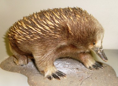 Conservation Volunteers
Echidna: Taxidermal Animal, To be established, Echidna - real and stylised: Taxidermal Animal - overseas visitors to CVA's head office clamour to be photographed with it, To be advised
ACRONYMS: The name of the organisation is Australian Trust for Conservation of Nature (ATCV) from 1981 to 1999 and Conservation Volunteers Australia (CVA) from 2000 onwards.............................................Last used in 1999 the Echidna logo was used for 17 years. It was designed by John Zulic, then a young graphic designer at Sovereign Hill Outdoor Museum in Ballarat, and by 2010 the longest serving employee. John was briefed by Peter Hiscock, then director of Sovereign Hill and also President of ATCV, in 1982 to design ATCV’s first logo. Through the image of the echidna John Zulic tried to capture a unique Australian identity (a combination of uniqueness, strength, resilience, role in a balanced habitat and a national feel) for a fledgling local group with big plans. John presented concept to Tim Cox and Peter Hiscock – both were enthusiastic: the rest is history. For many years newly arriving volunteers were photographed with the mascot.The echidna was synonymous with ATCV for many years. The logo appeared on team vehicles and buses and on all publications until 2000. For many years new volunteers had their photograph taken with "Eddy". Even today overseas visitors to CVA's head office clamour to be photographed with it.This item is a taxidermal (preserved and stuffed) echidna. The echidna is an Australian marsupial animal resembling the porcupine or hedgehog found in other continents. It is a nocturnal, burrowing, egg-laying mammal of the genera Tachyglossus and Zaglossus of Australia, Tasmania, and New Guinea, having a spiny coat, slender snout, and an extensible sticky tongue used for catching insects. NOTE: The provenance of this item is not yet established but it has been the unofficial "mascot" of ATCV/CVA from soon after foundation till the present.australian, echidna, mascot, logo, wildlife -
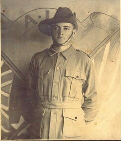 Emerald Museum & Nobelius Heritage Park
PHOTO, Eric William John Durance
Eric William John Durance ,Son of William and Margaret Durance of Macclesfield. Rank.Private. Service no. 812. Unit 22 nd Battalion Service Army Conflict 1914-1918 Date of Death 4th October 1915. Cause of Death Died of Wounds. CEMETERY OR MEMORIAL DETAILS. 6 Lone Pine Memorial Gallipoli. Place of enlistment Gembrook West Victoria. Native Place. Macclesfield Victoria War Grave Register notes. DURANCE, PTE. Eric William John, 812.22nd Bn. Died of wounds 4th. Oct. 1915. Son of William John Durance and Margaret Madigan (his ). Native of Macclesfield, Victoria, Australia. 65 Source. AWM145 Roll of Honour cards.1914-1918 War Army. LOCATION on the Roll of Honour. Eric Williams John Durance's name is located at panel 96 in the Commemorative Area at the Australian War Memorial (as indicated by the poppy on the plan).1914-1918 War Age at time of death 21Photo of Eric William Durance in his uniform from the 1914-1918 war.1st world war. -
 Eltham District Historical Society Inc
Photograph, Eltham State School No. 209, Dalton Street, Eltham, c.1918
Eltham Primary School. This building is the earliest building remaining on site today. It was built in 1875 and was the second school building replacing the original 1856 building of stone walls with wooden shingles on the roof. That building needed to be replaced after the stone walls collapsed outwards. In August 1912 the school issued a requisition for remodelling of the school concerned with replacement of the existing windows with larger and wider windows to allow additional light into the school rooms and the erection of a wooden partition in the centre of the room. This work commenced in early 1914 and this photo shows the altered windows. Pre 1921 extension and skylights in roof. Only two low wooden stairs present to enter the porch. These were rebuilt by 1928. A steel mud grate was introduced 1930s/1940s and an infant shelter shed is shown on the 1945 plan. Photo most likely taken between 1914 and 1921.This photo forms part of a collection of photographs gathered by the Shire of Eltham for their centenary project book,"Pioneers and Painters: 100 years of the Shire of Eltham" by Alan Marshall (1971). The collection of over 500 images is held in partnership between Eltham District Historical Society and Yarra Plenty Regional Library (Eltham Library) and is now formally known as the 'The Shire of Eltham Pioneers Photograph Collection.' It is significant in being the first community sourced collection representing the places and people of the Shire's first one hundred years.Digital image 4 x 5 inch B&W Negsepp, shire of eltham pioneers photograph collection, eltham, dalton street, state school no. 209, eltham primary school, eltham state school, schools -
 Glen Eira Historical Society
Album - Album page, Neerim Road, Circa 1972
This photograph is part of the Caulfield Historical Album 1972. This album was created in approximately 1972 as part of a project by the Caulfield Historical Society to assist in identifying buildings worthy of preservation. The album is related to a Survey the Caulfield Historical Society developed in collaboration with the National Trust of Australia (Victoria) and Caulfield City Council to identify historic buildings within the City of Caulfield that warranted the protection of a National Trust Classification. Principal photographer thought to be Trevor Hart, member of Caulfield Historical Society. Most photographs were taken between 1966-1972 with a small number of photographs being older and from unknown sources. All photographs are black and white except where stated, with 386 photographs over 198 pages. Property is included the City of Glen Eira's Amendment C190glen as HO177 Ida Villa. As of 18/03/2021, Amendment C190 is noted as "Approval Under Consideration" by the Minister of Planning.Page 147 of Photograph Album with one landscape photograph of a Victorian brick house on Neerim Road.Handwritten: Neerim Road [top left] / 234 [under photo] / 147 [bottom left]trevor hart, neerim road, arched windows, verandah, porch, decorative brackets, bull nosed verandah, cast iron columns, ross land sales, ross, carnegie, victorian style, cast iron work, polychrome bricks, brick houses, tessellated tiled deck, ida villa -
 Glen Eira Historical Society
Album - Album page, Seymour Road, Circa 1972
This album was created in approximately 1972 as part of a project by the Caulfield Historical Society to assist in identifying buildings worthy of preservation. The album is related to a Survey the Caulfield Historical Society developed in collaboration with the National Trust of Australia (Victoria) and Caulfield City Council to identify historic buildings within the City of Caulfield that warranted the protection of a National Trust Classification. Principal photographer thought to be Trevor Hart, member of Caulfield Historical Society. Most photographs were taken between 1966-1972 with a small number of photographs being older and from unknown sources. All photographs are black and white except where stated, with 386 photographs over 198 pages. As at 22/08/2021, 61 Seymour Road is included in the HO179 Beemery Park Precinct which C204glen Amendment seeks to add to the Glen Eira Planning Scheme (amongst others). This is not yet finalised.Page 191 of Photograph Album with four photographs of two different properties on Seymour Road. One photo on the left, with the other three all on the right. Handwritten: 61 [under top left photo] / 32 [under top right photo] / 32 [beside bottom right photo] / 191 [bottom left]trevor hart, elsternwick, seymour road, late victorian, italianate style, verandahs, cast iron work, gardens -
 Glen Eira Historical Society
Letter - Glen Huntly Festivals
This file contains five items: 1/An official programme for the Glenhuntly Traders Association’s Annual Christmas Festivals on 22/11/1986. 2/A handwritten letter from Vice President Kaye Georgiades of the Glenhuntly Traders Association to Mr. Balentine thanking him for photos lent. The letter is undated. 3/A typed letter from the Glenhuntly Traders Association to Mr. R. Ballantyne of the Caulfield Historical Society thanking him for helping and supporting the Festival and Payment Art Competition. Dated 30/10/1986. 4/Two typed letters from the Glenhuntly Traders Association to Mr. Ballantyne of the Caulfield Historical Society regarding planned activities for the 1986 and 1987 Christmas Festivals. 5/A black-and-white photograph of members of the Glenhuntly Traders Association, including Gus Theobold pictured on the left. The photo is undated and was published in the Caulfield Contact newspaper.glenhuntly traders, glenhuntly traders associations, caulfield festival, glenhuntly road, booran road, grange road, caulfield, watsons grove, glenhuntly newsagency, royal avenue, campbell j., farey j. mr., manchester grover, mayors, ryall m., caulfield historical society, glenhuntly bowling club, caulfield grammar band, caulfield baton twirlers, glenhuntly christmas festival, glenhuntly festival, truscott v., balentine mr., ballantyne r. mr., truscott v. mrs., neville street, carnegie, georgiades kaye, ford p., glenhuntly, glen huntly, glenhuntly pavement art festival, truscott vanessa, georgiades k., caulfield contact, theobold gus, glenhuntly shopping centre, local government, local officials and employees, associations, historical societies, bowling clubs, festivals and celebrations, festivities, musical ensembles, educational and research establishments, schools, business people, competitions, art competitions, commercial events and activities, officer workers, shows and exhibitions -
 Federation University Historical Collection
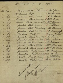
Handwritten document, Ballarat Junior Technical School - Records of raffle results - 1921, 09/09/1921 and 10/10/1921
Ballarat Junior Technical School opened in 1913. It was located at the Dana Street State School. As numbers grew a larger building was needed. Plans were drawn and a school built within the grounds of the School of Mines. Students started at this new school in 1921. It was officially opened on 9 September 1921 by Sir Alexander, resident of Creswick, local member for North Ballarat and the Minister for Education. He also opened the School Fair which coincided with the buildings ceremony. This was a fair on a grand scale and lasted two days and nights. Staff and students worked for weeks making articles for sale. A parent's committee led by Mr J Rogerson, a local police detective, had been organizing for months. Money raised funded the dodge-ball court, purchased a typewriter, a second-hand piano, an inter-room telephone system, an epidiascope and film projector. Four pages of lined paper showing handwritten results for raffles held at Ballarat Junior Technical Schhool in 1921. Pages held together with a dressmaker's pin.J Rogerson, official drawerballarat junior technical school, dana street primary school, ballarat school of mines, 1921, sir alexander, school fair, parent's committee, j rogerson, police detective, dodge-ball court, typewriter, piano, telephone system, epidiascope, film projector -
 Federation University Historical Collection
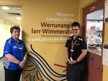
Photograph - Photographs - Colour, Renaming of the Wimmera Campus Library to Werrunangita larr Wimmerata, 2019, 11/2019
The dual-naming of the Wimmera Library took place in November 2019, and includes a name in local Wergaia language. The Horsham Campus is now known as “Werrunangity larr Wimmerata” (pronounced: Wherroon narn kitch – larr – wimmerartar) meaning “a quiet place in the Wimmera.” The official naming took place in the presence of Professor Helen Bartlett (Vice Chancellor who was joined by Aunty Jennifer Beer, Uncle Rob Fry, Geoff Lord (Horsham Campus Director) , Sue Owen (Library Director), Jasmine Graham (Manager of the Aboriginal Education Centre), Keith Caldwell (Facilities), Katrina Beer and artist Tanisha Lovett. This naming was the result of extensive teamwork and community consultation between local Aboriginal Elders, land councils, our Aboriginal Education Centre, as well as library and campus leadership. It is just one of the ways in which we are progressing our University’s Reconciliation Action Plan. Federation University librarians stand new artwork and signs for Werrunangita larr Wimmeratawerrunangita larr wimmerata, horsham campus, library, librarians, ann jardine, women -
 Puffing Billy Railway
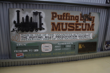
Sign - Puffing Billy Museum Entry
The Museum was first considered in 1963 when it was felt that Victorian narrow gauge railway history was quickly being destroyed by progress. Originally it was planned to only cater for two locomotives and some rolling stock associated with the Moe and Walhalla Railway. Construction of the site commenced on Labour Day Weekend in March 1964, the area was then fenced. The first exhibit arrived soon after and companies with locomotives and other railway features offered items to the Museum. When interesting exhibits from the "Steam Era " were known to be coming available,discussions were held with the owners in an attempt to obtain the item for preservation. In 1965 an Umbrella style shed was built and by May, the first locomotive ex Erica State Saw Mill (CLIMAX) had arrived. The Museum was opened to the public in November 1970 but was officially opened by His Excellency the Governor of Victoria, Sir Rohan Delacombe on Saturday 7th April 1973.Historic - Puffing Billy Museum Entry SignPuffing Billy Museum Entry Sign Rectangular hand painted sign in use from 1970.Puffing Billy Museum This is one of the Volunteer activities of The Puffing Billy Preservation Society Preserving part of our National Heritage Proud to Help Preserve Australia's Heritage puffing billy, menzies creek, sir rohan delacombe, narrow gauge, steam -
 The Adam Lindsay Gordon Commemorative Committee Inc.
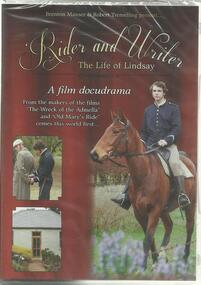
Film - DVD, Brenton Manser, Rider and Writer- The Life of Lindsay, 2014
From website: "Shot at various locations by cinematographer Robert Tremelling under the direction of Brenton Manser, the docudrama Rider and Writer is based on poet Adam Lindsay Gordon’s life during the time he lived in South Australia and Victoria. Manser has been researching, planning and developing the script for the new film since February 2012. Much of the footage for Rider and Writer has been shot in Mount Gambier, Port MacDonnell, Penola, Coleraine and Warrnambool. Jakin Manser has the leading role of Adam Lindsay Gordon, and former Grant High School drama teacher, David Reed, returned to Mount Gambier to act in the film, cast as John Riddoch, wealthy pastoralist and friend of Gordon. After 50 commended performances playing Riddoch in the stage production ‘Reckless’, Reed had retired. However, he was enticed by Manser to revive the character for the film."With a bust of Adam Lindsay Gordon in Westminster Abbey, London, his story is of national and international significance. Only one other film about Gordon is known to exist, produced in 1916. Allan Childs, curator of Gordon’s former residence ‘Dingley Dell’ is excited by the project: ‘To have a film that is made with the latest high definition equipment will bring the story of this famous poet alive to a new generation. We’ve come a long way since the black and white silent movies of 1916.’ The film premiered in Mount Gambier on 30 August 2014.adam lindsay gordon, brenton manser, robert tremelling, docudrama, 2014 -
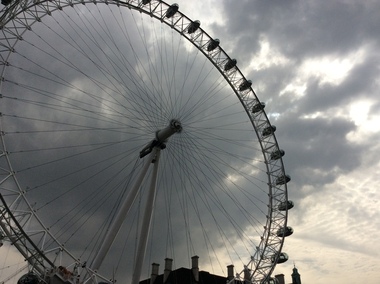 Ballarat Heritage Services
Digital photograph, Dorothy Wickham, The London Eye, 2016, 19/09/2016
At 135m, Coca-Cola London Eye is the world’s largest cantilevered observation wheel. It was conceived and designed by Marks Barfield Architects and was launched in 2000. It has won over 85 awards for national and international tourism, outstanding architectural quality and engineering achievement. In fact, it has become the UK’s most popular paid for visitor attraction. A remarkable feat of design and engineering, the London Eye gave London’s skyline a dramatic new addition and has been offering guests a new perspective on London ever since. Originally, it was intended as a temporary structure, able to be dismantled and transported to a new location, and had planning permission for just five years. But with millions boarding it every year, its popularity has prompted its lease to be extended. Today it is a permanent fixture on the London skyline and a beautiful symbol of modern London. (https://www.londoneye.com/about-us/#sthash.Xxd6iuOj.dpuf)london eye, ferris wheel -
 Ballarat Heritage Services
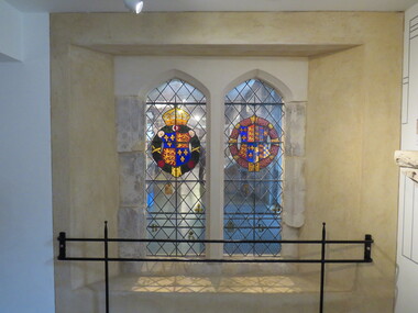
Photograph - Photograph - Colour, Greenwich Chapel and Museum, England
Greenwich Palace no longer exists however archaeology had added greatly to our understanding of life at the Tudor Court at Greenwich. Since 1971 there have been well over 20 digs on the site. Many wonderful and intriguing items from gold coins to tiled floors and human skeletons have been found. The first major dig uncovered the structure of the royal apartments next to the river. Not only did it clarify the floor plan but finds included some rare Tudor ceiling decorations, a hoard of gold coins and many personal items such as dice used for gaming. Perhaps the most revealing excavations have been the most recent. In 2005 while monitoring the digging of a drainage trench archaeologists found brickwork and tiles that formed the floor of the east end of the Tudor Chapel Royal where the altar once stood.Photograph of stained glass windows at Greenwich Chapel and Museum, Englandgreewich, stone, museum, chapel, stained glass -
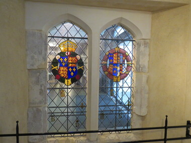
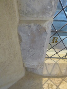
 Ballarat Heritage Services
Photograph - Colour, Greenwich Chapel and Museum, England, Mason's Mark on stonework
Greenwich Palace no longer exists however archaeology had added greatly to our understanding of life at the Tudor Court at Greenwich. Since 1971 there have been well over 20 digs on the site. Many wonderful and intriguing items from gold coins to tiled floors and human skeletons have been found. The first major dig uncovered the structure of the royal apartments next to the river. Not only did it clarify the floor plan but finds included some rare Tudor ceiling decorations, a hoard of gold coins and many personal items such as dice used for gaming. Perhaps the most revealing excavations have been the most recent. In 2005 while monitoring the digging of a drainage trench archaeologists found brickwork and tiles that formed the floor of the east end of the Tudor Chapel Royal where the altar once stood.greenwich, stone, museum, chapel -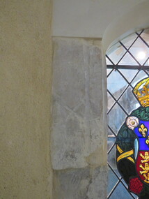
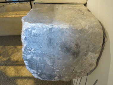
 Ballarat Heritage Services
Photograph - Photograph - Colour, Greenwich Chapel and Museum, England, Mason's Mark on stonework, 2017
Greenwich Palace no longer exists however archaeology had added greatly to our understanding of life at the Tudor Court at Greenwich. Since 1971 there have been well over 20 digs on the site. Many wonderful and intriguing items from gold coins to tiled floors and human skeletons have been found. The first major dig uncovered the structure of the royal apartments next to the river. Not only did it clarify the floor plan but finds included some rare Tudor ceiling decorations, a hoard of gold coins and many personal items such as dice used for gaming. Perhaps the most revealing excavations have been the most recent. In 2005 while monitoring the digging of a drainage trench archaeologists found brickwork and tiles that formed the floor of the east end of the Tudor Chapel Royal where the altar once stood.Colour photograph of Greenwich Chapel and Museum, England, Mason's Mark on stoneworkgreenwich, stone, museum, chapel -
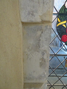
 Ballarat Heritage Services
Photograph - Colour, Greenwich Chapel and Museum, England, Mason's Mark on stonework
Greenwich Palace no longer exists however archaeology had added greatly to our understanding of life at the Tudor Court at Greenwich. Since 1971 there have been well over 20 digs on the site. Many wonderful and intriguing items from gold coins to tiled floors and human skeletons have been found. The first major dig uncovered the structure of the royal apartments next to the river. Not only did it clarify the floor plan but finds included some rare Tudor ceiling decorations, a hoard of gold coins and many personal items such as dice used for gaming. Perhaps the most revealing excavations have been the most recent. In 2005 while monitoring the digging of a drainage trench archaeologists found brickwork and tiles that formed the floor of the east end of the Tudor Chapel Royal where the altar once stood.greenwich, stone, museum, chapel -
 Ballarat Heritage Services
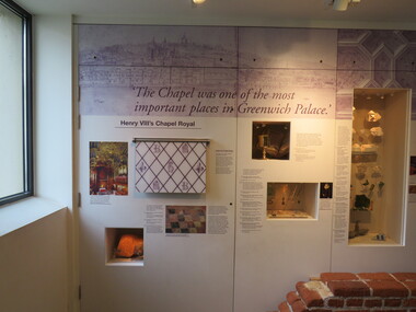
Photograph - Colour, Information panel, Greenwich Chapel and Museum, England, 2016
Greenwich Palace no longer exists however archaeology had added greatly to our understanding of life at the Tudor Court at Greenwich. Since 1971 there have been well over 20 digs on the site. Many wonderful and intriguing items from gold coins to tiled floors and human skeletons have been found. The first major dig uncovered the structure of the royal apartments next to the river. Not only did it clarify the floor plan but finds included some rare Tudor ceiling decorations, a hoard of gold coins and many personal items such as dice used for gaming. Perhaps the most revealing excavations have been the most recent. In 2005 while monitoring the digging of a drainage trench archaeologists found brickwork and tiles that formed the floor of the east end of the Tudor Chapel Royal where the altar once stood.greenwich, stone, museum, chapel