Showing 993 items
matching paddocks
-
 Eltham District Historical Society Inc
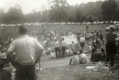
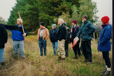
Photograph, Ron Kirkbride, Wattle Glen Picnic Ground, c.1971, 1971c
The Wattle Glen Picnic Ground was located in a paddock just west of the Wattle Glen railway station (between the station and the creek). It has now completely disappeared except for a dilapidated overgrown building on a rise across the track from the railway platform. This was the picnic ground's main pavilion, which for a short time (circa 1972-1974) also served as the Wattle Glen post office and general store. The picnic ground operated from circa 1925 until late 1974, its heyday being in the early 1970s. It was then managed by Ron and Barbara Kirkbride and was a thriving operation. The pavilion housed a substantial kiosk as well as toilets and showers. There were swings and slides for children, and there was an oval for cricket and football matches. Large group bookings became so popular that often the general public were excluded. This photo is believed to have been taken in about 1971. Digital copies of four black and white photographswattle glen, picnic ground -
 Orbost & District Historical Society
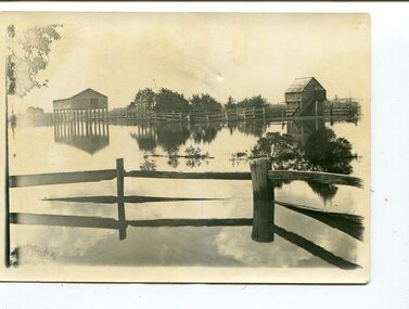
black and white photographs, 1890s
Peter Cameron, came to Orbost in 1885, at the age of 69, having sold his farm at Geelong. Peter bought the property ―Glen Avon from a Mr Street. The home was situated at the bottom of the paddock, near the corner of Morley and Livingstone streets. The farm stretched from Tennyson Street to the end of Snaggers Lane and along the river frontage to “Carinya” Cameron Home. In the Gippsland Times on Wednesday. 2 Jul 1890 on Page 3 is an article titled "THE SNOWY RIVER CALAMITY" which describes an ".unexpectedly sudden rush of water down the flats..... the terrified people commenced to remove their stock from the land and the work of saving property was continued all day ............ many head of cattle were washed away.......The river road, for its entire length, is obliterated, and the approaches to the bridge at Watt's Gulch are gone, with the enormous volume of flood water," These photographs are pictorial records of a significant event in the history of Orbost. There are few personal records of the very early floods.Three black / white photographs of wooden buildings with flood water in foreground. There are post and rail fences. 3193.2 has been taken from a distance.on back -" "Glenavon east of Lagoon 1897 Feb"floods-orbost-1890s glenavon-orbost -
 Tatura Irrigation & Wartime Camps Museum
Photos, Arthur Severino, Garrison at Dhurringile, a garrison member at Dhurringile, 1939-1940
Photos in possession of Arthur Severino, a garrison member at Dhurringile, who also helped maintain the powerplant?. Passed on to his son, William (Bill) on his death, along with a sketch of Dhurringile (cat. C0906). The only information known about the photos is what was written on or beside them & that they were from Arthur's time served as a garrison member at Dhurringile. Arthur also apparently helped to maintain the powerplant whilst at Dhurringile. (Some photos of barracks may have been taken at Puckapunyal instead, where he went immediately after Dhurringile, to enlist in 2nd AIF). 1. Arthur in front of barracks doorway 2. Barracks? building 3. View of camp?? 4. Dhurringile mansion, unknown civilians in entrance (caretakers??) 5. Three people seated, Arthur on left 6. View of fenceline, paddocks, possibly Waranga Basin in background 7. Large water tankSeven photos in possession of Arthur Severino, garrison member at Dhurringile November 1939 - June 1940. 3. "March 1940" 4. "November 1939" 5. "Lance Sergeant Arthur James Severino (on left) V82052, 5th Workshop and Park COY. ; Later VX25922 HQ 21st Aust Infantry Brigade 2nd AIF; Tatura 1939" 6. "March 1940" 7. "March 1940"dhurringile, arthur severino, william severino, dhurringile mansion garrison members, puckapunyal, 2nd aif -
 Sunshine and District Historical Society Incorporated
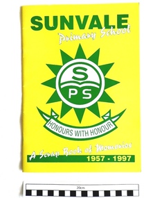
School Magazine, SUNVALE PRIMARY SCHOOL - 'A Scrap Book of Memories 1957 - 1997', Probably about 1997
The Sunvale Primary School was situated on Neil Street, near Hertford Road, Sunshine, on the former Moons paddock. The school was officially opened on the 9th of October 1957 with an enrolment of 214 students. Most of the students were transferred from the overcrowded Sunshine, and Sunshine East Primary Schools. The acting head teacher and five temporary teachers came from the East Sunshine Primary School from which about 170 students also came. During the later years the school operated as part of a three campus primary school complex formed between Sunvale Primary School, Sunshine East Primary School, and Braybrook Primary School. After the modern Sunshine Harvester Primary School was built on the East Sunshine Primary School site, the students from the Braybrook and Sunvale schools were transferred there. Sunvale Primary School was closed on 9th September 2009.The magazine is a historical record of the initial 40 years of the school and of activities associated with the school. It contains the names of the Principals, from Mr. Bartels in 1957 to Mr. A. Dash in 1997, and also the names of Chairs of the School Council, from Mr. F. Sanford to Mr. T. Cuddy. It also features articles on the history of the school, the mothers club, the parents & friends members, special events & features, class & staff photographs, sport, and has a memories section. The special events & features section includes the school ball, camps, the Governor's visit in 1995, and Sunvale's famous Olympian staff member Pam Kilborn.Bright yellow covered 40 page book with green and white printing on the cover. A large emblem of the no longer existing SUNVALE PRIMARY SCHOOL is featured on the front cover, and a smaller version is on the back. The magazine is described as "A Scrap Book of Memories", and covers the years 1957 to 1997.SUNVALE Primary School S/PS HONOURS WITH HONOUR A Scrap Book of Memories 1957 - 1997sunvale, primary school, school magazine, scrap book of memories, moons paddock, 1957, 1997, bartels, dash, sanford, kilborn, cuddy -
 Westbourne Grammar Heritage Collection
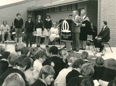
Photograph - Official opening of stage 1 building of the new campus 1979
Principal John Pascoe stands behind Senator John L. Carrick as he speaks at the official opening of stage 1 building of the new campus at Truganina, February 1979. Classes began in temporary classrooms a year earlier and students reflected on the hive of activity while buildings went up around them in the 1978 yearbook, Literata: 'We still had to put up with the noise of the builders finishing the building' D.W 'There was hardly anything to be taught in...I thought it was disorganised, lonely and hectic' K.H. 'I do not know how the workers completed the school in such a short time' A. DiM. In a longer piece, past student and school captain, Fiona Kellett, wrote: 'Where once there were just paddocks, we now have a fine school, of which we are very proud. In the years to come this school will become bigger and everyone will see their dreams and hard work fulfilled'. Black and white photograph of a group of people seated facing a stage. On the stage, four students stand to the left of a podium at which Senator John. L. Carrick is speaking. -
 Kew Historical Society Inc
Photograph, Chipperfield's Boat House & Floating Pontoon, 1934
Living with natural processes was frequently a challenge to early European settlers and later residents of what was in the 1850s administered by the Borondara Road Board. This was compounded by the area being bounded on three sides by rivers (Yarra River, Koonung Creek and Gardiner's Creek). In 1849, the historian James Bonwick recorded that "our district [Kew] suffered considerably. Mr Wade speaks of 80 acres, out of 100 acres of his cultivated paddock, covered by water." Newspapers continued to describe major flooding in Kew in 1863, 1869, 1878, 1880, 1889, 1891, 1916 and 1934. While the construction of the Upper Yarra dam in 1957 reduced the levels of flowing downstream, local and riverine floods continue. A number of boat houses operated on both sides of the River Yarra at Kew. Chipperfield's Boat House was located on the Yarra near the corner of Kilby and Willsmere Roads.The Kew Historical Society's pictures and map collections testify to the impact of flooding in the district. They have historical importance in documenting the extent of flooding in the district and its affects on homes, services and recreation. Numerous photographs record flooding throughout the Twentieth Century.Floating pontoon at Chipperfield's Boat House where the canoes were stored, taken in 1934, presumably before the 1934 Flood. This area of the Yarra was shallow with a number of mid river sandbanks and a popular swimming area for locals.yarra river, chipperfield's boathouse, pontoon -
 Wooragee Landcare Group
Photograph, 20th June 2004
Photo of streamside planting and rehabilitation at Bev DeJong and Bob Dunnett's place during a paddock demonstration and tree planting field day, called 'Really Successful Tree Planting!' run by Wooragee Landcare on Sunday 20th June 2004. Maintaining and reforesting native trees, shrubs and grasses are really important for a variety of reasons, including creating native habitat and food for birds and other animals, shade, biodiversity, visual appeal, cooling, shade for urban areas, sequestering carbon and conservation among other considerations. The planting must be consistent with the particular needs of the environment, such as trees or shrubs which would naturally occur and are native to the area. Tree planting demonstrations such as this one run by the Landcare Group ensures that the projects are being managed consistently with an overarching commitment to land protection and management and the best methods for best outcomes are employed.This photograph is significant as it provides evidence of a project undertaken by the Wooragee Landcare Group to educate themselves and members of the public on successful techniques needed to plant and maintain trees for replanting in the Wooragee area. The Wooragee Landcare Group has been instrumental in the co-ordination of programs relating to biodiversity protection in the local area, providing great assistance to landholders.Landscape coloured photograph printed on gloss paperReverse: WAN NA 0ANA2N0 AN1 0 1636 / [PRINTED] (No.25) / 938wooragee landcare, wooragee landcare group, beechworth, landcare group, wooragee, tree planting, successful tree planting, demonstration, paddock demonstration, tree planting field day, really successful tree planting, land protection and management, land management, native trees, conservation, streamside, streamside planting -
 Clunes Museum
Document, 1875, 1876,1878
.1 Green page headed "Yankee Tunnel" showing dates and depths dug and depths of tunnel costings on reverse of page, calculations in centre .2 Blue page dated 14 January 1876 headed "Tunnel" showing costings, amount sold, on the reverse shows 1875 dividents with amounts. Also a lost of names and amounts (these have been crossed through) .3 Cream coloured card with 1948 calendar printed on it .4 Memo from Clunes Water Supply dated 6 May 1878 detailing cost of laying on water; Memo addressed to Messrs Hudson's & Sons, Paddock. .5 Blue page dated 21.4/1877 headed "Tunnel" showing costings, amount sold.yankee tunnel, gold mine costings -
Surrey Hills Historical Society Collection
Document - Plans, Andrew Wood, Building plans associated with Andrew Wood, builder of Surrey Hills, 1920s
These plans were associated with Mr Andrew Wood, a contract builder who worked in the 1920s and built many Californian bungalows in Surrey Hills and surrounding suburbs. Andrew Wood was born in Chiltern in 1861 to Andrew and Ellen Wood (MS: Green). His father had emigrated from Falkirk, Scotland. As a young man Andrew worked as a carpenter in the mines in South Africa (c 1899). He married Eleanor Agnes Stuchbery in Hamilton, Victoria in May 1901. They had 5 children - Doris (M Roberts), Robert Andrew, Donald Allen, Jean (M Cowan), and Gwenyth (M Bray). The first 2 children were born in Hawthorn; the other 3 in Surrey Hills. The family home at 286 Canterbury Road, Surrey Hills (on the corner of Middlesex Road) was built by Andrew. Andrew died in 1940; Eleanor died in 1977, aged 100 years. After Eleanor's death the house was sold and demolished. Surrey Lighting was established on the site. Gwenyth May Wood (3 May 1917, Surrey Hills - 5 Jan 2004) married Leslie David Charles Bray (1921-1983). Gwenyth was the donor's mother. Andrew, Eleanor and one son Robert are buried in Box Hill Cemetery - B-071-0028. .1: Specifications & plans for the kinder hall, Howard Street, Mont Albert for the Mont Albert Methodist Church, May 1925 .2 Plans for a proposed villa, 48 Payne's Paddock, Highfield Road, Canterbury for Mr E H Sillifant, dated 22/4/1920 .3 Plans for a timber villa for Mrs J A Burchell at Riversdale Road, Surrey Hills, stamped 9/5/1922 .4 Plan of a garage at Victoria avenue, Canterbury; stamped 14/2/1922 .5 Building permit & receipt from City of Hawthorn re Lot 16 Homebush Crescent; dated 7/4/1925 .6 Plans for a concrete house at Camberwell for Mr H W Field andrew wood, builders, box hill cemetery, kindergartens, mont albert methodist church, building plans, highfield road, ernest horatio sillifant, victoria avenue canterbury, lot 16 homebush crescent, californian bungalows, h w field -
 University of Melbourne, Burnley Campus Archives
Slide - 35mm Colour slides, Miscellaneous Burnley, 1968-1974
1. Entrance Swan Street, Richmond Oct 68. 2. Greenhouse equipment Nov 68. 3. "J. Firth" Nov 68. 5. "B. Gdns Tech Block" Oct 69. 4, 6, 7. Lagoon Paddock. 6, 7. April 1969 Garden views 8, 9 May 69 Garden views. 10. "Shepherds Moorooduc" Feb 70. 11. "B. Gdns Principals Residence", 12. "B. Gdns Oak Tree" Oct 70. 13. "Strawberry Over Plastic Grampians Sep 72" Oct 72. 14. "Mildura School Bus", 15. "Irymple. R.S.I. Thornton" Jul 73. 16. "Citrus (Pruned) Sept", 17. "Student Plots 1974" Nov 74.tech block, garden views, principals residence, oak tree, school bus, student plots, swan street entrance, greenhouse equipment, j firth, shepherds moorooduc, strawberries grampians, mildura camp, irymple thornton, students working outside, lagoon paddock, principal's residence, engineering, citrus -
 Kiewa Valley Historical Society
Folder - Kiewa Methodist Church, 1917 to 1962
The copy of a letter written by Harry H. Simmonds of Huon notes that "the church existed in 1905. It was built by Hill and McCormack with timber donated by Mr Ned Dunstan on ground donated by Mr James Thomas probably in the late 1800s. It was possibly called a Methodist Church because the donor of the land was a Methodist. It was used by the three Protestant Groups and maintenance was paid for by an annual area collection.The house on the west side was a Presbyterian Manse for many years and the block of ground on the north side was known as the Manse paddock in which the minister grazed his cow and horse." In 1936 there was a fence between the Kiewa Methodist Church was the Presbyterian Church in Kiewa. Its Certificate of Title is Volume 5134 Folio 1026783 (Sept. 1942.) In 1952, the church was made of wood with an iron roof. In 1954. Request to Yackandandah Shire re a fence from Kiewa Consolidated School entrance to the unused hedge adjacent to the Church. In 1958 there was correspondence re 'the strip of land on each side of the Church.' Churches were an important part of life during the late 19th century and early to mid 20th century and were built in the centre of town as was this one. These papers give an understanding of the work involved in maintaining a church. The letters and 'book' give a lot of names of local families involved with the Methodist Church at Kiewa. Yellow plastic spiral folder with 18 pages enclosed in clear plastic sleeves.Papers enclosed include accounts, payments, tenders and other correspondence relating to the Methodist Church at Kiewa dating from 1932 to 1962. Of particular interest is a black cardboard cover book dated 1917 re collection of donations from listed people. The latest date in the book is 1942.Enclosed in first plastic sleeve is a letter from the donor, Kathie Vines dated 15th July 2013methodist church; kiewa; harry h. simmonds; yackandandah council; -
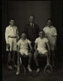 Federation University Historical Collection
Photograph - Black and White, Richards & Co, Ballarat Junior Technical School - Tennis Team 1938, 1938
Sport and available playing areas were important and every effort was made to provide this for the students when they moved into the new building in 1921. The terraces leading down from the gaol wall were terraced and clearing areas of rubble to provide playing areas for football and cricket was done by the students. In November 1922, a tennis court was opened in the Battery Paddock. It was designed by Syd Chambers and constructed by Les Waller, former students of the Ballarat School of Mines. A new tennis court was built and opened in 1934, in the same area. This photograph is of the 1938 Tennis Team - Ballarat Junior Technical School. The boys standing are L to R: D. Eltringham and J. Burt. Seated on the left is W. Rowe and W. Edwards on the right. They are with Mr J. Hosie - staff member 1938-41. Donald Eltringham was Dux of the school in 1938. He obtained a Diploma in Electrical Engineering and Mechanical Engineering from the School of Mines Ballarat - 1944/47A formal group of four boys in tennis outfits with racquets and one adult male.Photographer's stamp embossed on front with rubber stamp on back "Richards & Cc - photographers - Ballarat. In pencil - "Jun Tech" and "1938"tennis court, battery paddock, syd chambers, les waller, ballarat school of mines, 1938 tennis team, ballarat junior technical school, eltringham, burt, rowe, edwards, j. hosie, electrical engineering, mechanical engineering -
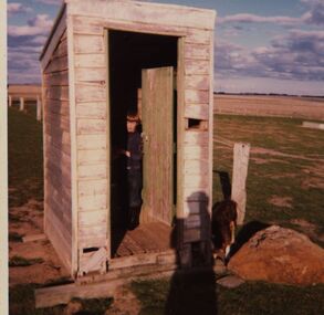 Federation University Historical Collection
Photograph - Colour, Chatham-Holmes Collection: Andrew Chatham in the Out House, Kur-a-ruc South, Rokewood, Vic. {circa 1976)
Andrew Chatham, the youngest of Philip and Elizabeth Chatham's 5 children, was born in 1968. In this photo, he looks about 8 - 10 years old. The photo was taken at Rokewood, Victoria on his parent's Western District property, "Kur-a-ruc South" a former part of the Kur-a ruc Station, Rokewood, Victoria purchased by Philip and Elizabeth Chatham in 1964. The family lived at Ascot, 15 miles north of Ballarat, and had regular weekend day trips and Easter holidays picnicking, droving sheep, feeding stock, checking water troughs and dams, hand-weeding Patterson curse, repairing fences, collecting paddock rocks and sugar-gum wood at "Kur-a-ruc South'. Home base for these excursions was either a car, the shearing shed, sometimes a 6-berth caravan and by the mid-1980s a shearer's quarters with an inside toilet. [Jane Dyer (nee Chatham).15 June 2024] chatham-holmes collection, andrew chatham, outdoor shed, toilet facility, rokewood, kur-a-ruc south, rokewood -
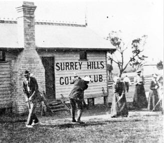 Surrey Hills Historical Society Collection
Photograph, Surrey Hills Golf Club clubhouse and players
Reproduced by permission of Mr John Arnold from his book: "The Riversdale Golf Club - a history, 1892-1977." Copyright to book: Riversdale Golf Club. Surrey Hills Golf Club operated from 1892-1908 then moved and became Riversdale Golf Club. The game was played across paddocks from Trafalgar Street, Mont Albert to Whitehorse Road and down Victoria Crescent to where Box Hill TAFE is now located in Elgar Road. There were problems with cows eating the tee flags! The clubhouse still exists as 30 Trafalgar Street. The Surrey Hills Golf Club was founded by Mr Hugh W McLeod in 1894. The first president was Mr A W Harston. Mr William Meader was the first honorary secretary and the club champion for several years. Another notable identity was Mr. Harry Culliton, who contributed golf notes to "The Argus" for many years.The image is significant in documenting the Surrey Hills Golf Club which is no longer in existence.Black and white photo of a timber building with an ornamental roof ridge and brick chimney. Two men in 'plus fours' and hats and three women in long dresses and hats have golf clubs in their hands. The men and one lady are practising swings. There is a mature tree in the background with a house to the right."A group of Surrey Hills players practising in front of the clubhouse early this century. The player in the background is heading towards the first tee. The house to his right can still be seen at 3 Beatty St., Mont Albert."sports grounds, surrey hills golf club, riversdale golf club, timber building, clothing and dress, john arnold -
 Wodonga & District Historical Society Inc
Album - Ringer's River by Des Martin - Plate 25 - Horse stealing revealed and financial dealings
Without knowing anything about the ring-in O'Day turns up at the races. Discovering a hidden brand on Smokey that could only have been burnt into Grapeshot's hide, and holding no belief for the crook administration at Nuggety Flat, he canters smartly down to the home of an old Chinese whose life his father saved during the Lambing Flat riots. Chin lends him 500 sovereigns. Waiting till O'Hara and Co. are "set" O'Day cleans up for himself and Chin, and quietly heads for home. Later he corners young O'Hara who confesses to the job, says Grapeshot is safely back in his paddock, and that Smokey has been sold to a Sydney show team owner and is well out of the district. O'Hara takes his money to the Camoola banker Redfern, who has befriended him, and clears up all his financial affairs. W.O. Tom Foster as Redfern.The album and images are significant because they document literature written by a prominent member of the Wodonga community. The presentation of this precis was supported by several significant district families and individuals.Ringer's River Album Coloured photo Plate 25des martin, many a mile, ringer's river, northeast victoria stories -
 Wooragee Landcare Group
Photograph, 20 June 2004
Photo shows, (L-R): Luke Bayley; Ray Henderson; Chris Robinson; Ann Henderson; Lesley Finedon, assessing successful stream side rehabilitation at Bev DeJong and Bob Dunnett's place during a paddock demonstration and tree planting field day, called 'Really Successful Tree Planting!' run by Wooragee Landcare on Sunday 20th June 2004. Maintaining and reforesting native trees, shrubs and grasses are really important for a variety of reasons, including creating native habitat and food for birds and other animals, shade, biodiversity, visual appeal, cooling, shade for urban areas, sequestering carbon and conservation among other considerations. The planting must be consistent with the particular needs of the environment, such as trees or shrubs which would naturally occur and are native to the area. Tree planting demonstrations such as this one run by the Landcare Group ensures that the projects are being managed consistently with an overarching commitment to land protection and management and the best methods for best outcomes are employed.This photograph is significant as it provides evidence of a project undertaken by the Wooragee Landcare Group to educate themselves and members of the public on successful techniques needed to plant and maintain trees for replanting in the Wooragee area. The Wooragee Landcare Group has been instrumental in the co-ordination of programs relating to biodiversity protection in the local area, providing great assistance to landholders.Landscape coloured photograph printed on gloss paper.Reverse: WAN NA 0ANA2N0 NNN-1 1636/ [PRINTED] (No.23)/936/wooragee landcare, wooragee landcare group, beechworth, landcare group, wooragee, tree planting, successful tree planting, demonstration, paddock demonstration, tree planting field day, really successful tree planting, land protection and management, land management, native trees, conservation -
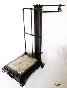 Flagstaff Hill Maritime Museum and Village
Functional object - Platform Scales
Thaddeus Fairbanks (1796 –1886) was an American inventor. of heating and cook stoves, cast iron ploughs, and other items. His greatest success was the invention and manufacture of the platform scale, which allowed the weighing of large objects accurately. Fairbanks was born in Brimfield, Massachusetts, on January 17, 1796, the son of Joseph Fairbanks (1763–1846) and Phebe (Paddock) Fairbanks (1760–1853). His uncle was Ephraim Paddock, the brother of Phebe Paddock. In 1815 he moved to St. Johnsbury, Vermont, and set up a wheelwright's shop above his father's gristmill. In 1820 he married Lucy Peck Barker and In 1824 he built an iron foundry. his brother Erastus joined him to establish E. and T. Fairbanks, a partnership to manufacture heating stoves, cast iron ploughs a design for which he patented in 1826. In 1830 Fairbanks and Erastus became interested in the raising and processing of hemp. Fairbanks went on to patent a hemp and flax dressing machine and became the manager of the St. Johnsbury Hemp Company. He also built a set of scales that would measure large loads of hemp accurately, as there were no reliable scales at the time. Upon the success of building these scales, his brothers recommended that he make and sell these for general use. Fairbanks' most famous invention then became the platform scale for weighing heavy objects. These are commonly known as the Fairbanks Scales, for which he patented his original design in 1830. Before this time, accurate weighing of objects required hanging them from a balancing beam as a result, particularly heavy or ungainly objects could not be weighed accurately. A platform scale, if large enough, could weigh an entire wagon. By placing a full wagon on the scale, unloading it, and then placing it on the scale when empty, it became possible to easily and accurately calculate the weight and value of farm produce and other loads. In 1834 Fairbanks and his brother formed "E. and T. Fairbanks and Company" to manufacture and sell these platform scales. These scales were well known in the United States and around the world resulting in the company doubling in volume every three years from 1842 to 1857. There was a temporary slow down during the American Civil War, however, the business took off again after the war. Their partnership was incorporated in 1874 into a firm known as "Fairbanks Scale Company". These platform scales revolutionized weighing methods of large loads and have been in use ever since. Portable platform scales are found in almost every hardware store, physician's office, and manufacturing factory throughout the United States and the world. The first railway track platform scale patent was granted to Fairbanks on January 13, 1857, as Patent No. 16,381. In 1916 the company was purchased by ”Fairbanks, Morse and Company”. Ownership of the company has since changed several times, but Fairbanks Scales continue to be made in St. Johnsbury Vermont to this day. Fairbanks had received 43 patents in his lifetime with the last one at the age of 91. He died on April 12, 1886, and is buried at St. Johnsbury, Vermont, at the Mount Pleasant Cemetery. An early example of the first type of platform scale that revolutionised the weighing of goods throughout the world made in the USA around the turn of the 19th century. Commercially built platform scale on wheels. Cast iron base supports iron weighing platform with wooden floor. At back, square hollow wooden post supports a hooded rod which bears the weight of the platform and which hooks onto a brass balancing arm, marked in pounds up to 50. There is a cylindrical sliding weight and on the end a loop for a metal weight holder. The holder is designed for three circular pieces of metal with a slit to the centre. The weights used are 50, 100 and 200 lbs.Embossed to base Fairbanks Patent No 11 1/2, flagstaff hill, warrnambool, shipwrecked-coast, flagstaff-hill, flagstaff-hill-maritime-museum, maritime-museum, shipwreck-coast, flagstaff-hill-maritime-village, platform scales -
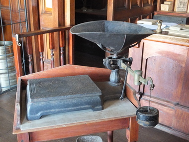 Flagstaff Hill Maritime Museum and Village
Functional object - Platform Scales, Thaddeus Fairbanks, 1880-1910
Thaddeus Fairbanks (1796 –1886) was an American inventor. of heating and cook stoves, cast iron ploughs, and other items. His greatest success was the invention and manufacture of the platform scale, which allowed the weighing of large objects accurately. Fairbanks was born in Brimfield, Massachusetts, on January 17, 1796, the son of Joseph Fairbanks (1763–1846) and Phebe (Paddock) Fairbanks (1760–1853). His uncle was Ephraim Paddock, the brother of Phebe Paddock. In 1815 he moved to St. Johnsbury, Vermont, and set up a wheelwright's shop above his father's gristmill. In 1820 he married Lucy Peck Barker and In 1824 he built an iron foundry. his brother Erastus joined him to establish E. and T. Fairbanks, a partnership to manufacture heating stoves, cast iron ploughs a design for which he patented in 1826. In 1830 Fairbanks and Erastus became interested in the raising and processing of hemp. Fairbanks went on to patent a hemp and flax dressing machine and became the manager of the St. Johnsbury Hemp Company. He also built a set of scales that would measure large loads of hemp accurately, as there were no reliable scales at the time. Upon the success of building these scales, his brothers recommended that he make and sell these for general use. Fairbanks' most famous invention then became the platform scale for weighing heavy objects. These are commonly known as the Fairbanks Scales, for which he patented his original design in 1830. Before this time, accurate weighing of objects required hanging them from a balancing beam as a result, particularly heavy or ungainly objects could not be weighed accurately. A platform scale, if large enough, could weigh an entire wagon. By placing a full wagon on the scale, unloading it, and then placing it on the scale when empty, it became possible to easily and accurately calculate the weight and value of farm produce and other loads. In 1834 Fairbanks and his brother formed "E. and T. Fairbanks and Company" to manufacture and sell these platform scales. These scales were well known in the United States and around the world resulting in the company doubling in volume every three years from 1842 to 1857. There was a temporary slow down during the American Civil War, however, the business took off again after the war. Their partnership was incorporated in 1874 into a firm known as "Fairbanks Scale Company". These platform scales revolutionized weighing methods of large loads and have been in use ever since. Portable platform scales are found in almost every hardware store, physician's office, and manufacturing factory throughout the United States and the world. The first railway track platform scale patent was granted to Fairbanks on January 13, 1857, as Patent No. 16,381. In 1916 the company was purchased by ”Fairbanks, Morse and Company”. Ownership of the company has since changed several times, but Fairbanks Scales continue to be made in St. Johnsbury Vermont to this day. Fairbanks had received 43 patents in his lifetime with the last one at the age of 91. He died on April 12, 1886, and is buried at St. Johnsbury, Vermont, at the Mount Pleasant Cemetery. An early example circa 1900 of the first type of platform scales used in a grocery store. This design for accurately measuring goods that were sold over the counter revolutionised the weighing of goods throughout the world. Platform scale metal black with removable tray & pan. Has horizontal brass arm with a brass slide weight black removable weight hook and 2 x 2 lb. weights. Fairbanksflagstaff hill, warrnambool, shipwrecked-coast, flagstaff-hill, flagstaff-hill-maritime-museum, maritime-museum, shipwreck-coast, flagstaff-hill-maritime-village -
 Kew Historical Society Inc
Photograph, J F C Farquhar, Wellington Street From High Street, 1891
At the beginning of the 1890s, the Kew businessman and Town Councillor, Henry Kellett, commissioned J.F.C. Farquhar to photograph scenes of Kew. These scenes included panoramas as well as pastoral scenes. The resulting set of twelve photographs was assembled in an album, Kew Where We Live, from which customers could select images for purchase.The preamble to the album describes that the photographs used the ‘argentic bromide’ process, now more commonly known as the gelatine silver process. This form of dry plate photography allowed for the negatives to be kept for weeks before processing, hence its value in landscape photography. The resulting images were considered to be finely grained and everlasting. Evidence of the success of Henry Kellett’s venture can be seen today, in that some of the photographs are held in national collections.It is believed that the Kew Historical Society’s copy of the Kellett album is unique and that the photographs in the book were the first copies taken from the original plates. It is the first and most important series of images produced about Kew. The individual images have proved essential in identifying buildings and places of heritage value in the district.Very few of the natural or built features in this panoramic photograph of Wellington Street remain. The open land between High Street South and Denmark Street, then known as O’Shannessy’s Paddock, was to become a residential subdivision at the beginning of the 20th Century. On the far side of Denmark Street, bordered by a picket fence, is the Kew Railway Station (demolished 1957). Further east, the large building with the flagpole is the Kew Recreation Hall (demolished 1960), which was the centre of civic life for almost a century. The building was used for dances, civic functions and exhibitions. A bowling green, tennis courts, and a cricket ground surrounded the Hall. The dominant building in the photograph is Xavier College, founded in 1872 by the Society of Jesus. The first classes for pupils were held in 1878. It is presumed that Farquhar used its roof for two of his bird’s eye views.Wellington Street from High Streetkew illustrated, kew where we live, photographic books, henry kellett -
Glen Eira Historical Society
Document - Lempriere Family
Five items about the Lempriere family: 1/Two pages of handwritten (unsigned and undated) research noting their land holdings, taken from the rate books over period 1858-1892. It shows us that John Thompson Lempriere was also Mayor in 1903. 2/Two pages of handwritten (unsigned and undated) notes about Thomas Henry Lempriere and William Geo Lempriere. 3/Photocopied photograph of 'Greenmeadows' on Lemprieres' cow paddock – undated and unknown. 4/Copy of article written by Michael Collins Perse from The Sydney Morning Herald 12/01/2009 on Michael Raoul Lempriere, 'Wool Industry Leader', 11/11/1936-01/10/2008, a descendant of Caulfield's Lempriere family. The article gives a short history of the family involvement in the wool industry. A short family tree history and more about Michael's early life and then his own family and business life. 5/A reprinted family tree from the Australian Dictionary of Biography for the Lempriere family by Justin J Corfield.lempriere thomas h., greenmeadows house, lempriere james, balaclava road, lempriere t.e., hotham street, lempriere john thompson, inkerman street, lempriere carlotta, lempriere mary, lempriere estele, lempriere jane, orrong road, lempriere william, george lempriere, monteiro d’almedin charles charles, stables, outbuildings, graziers, mansions, caulfield common school, committees of management, st marys, blake & riggall solicitors, ratebooks, greenmeadows, cow paddocks, lempriere michael raoul, lempriere bros, lempriere pty. ltd., lempriere peter, lempriere rozel, lempriere william henry, lempriere kathleen, lempriere audley raoul, sportspeople, greene adelaide, lempriere geoffrey, dougall diana, lempriere william, lempriere ben, australian council of wool buyers, federation of australian wool organisations, lempriere lisa, lempriere kristine, persse michael collins -
 Kew Historical Society Inc
Photograph - Civic event in Stradbroke Park, 1976
Stradbroke Park. Extent: Kilby Road to Harp Road at Burke Road. Historical Documentation: 1851 - Portion 91 purchased by Edward Glynn; 1888 - The Harp of Erin Estate (which included Section 91) offered for sale; 1896 - The area now known as Stradbroke Park was bisected by a creek that flowed from the Yarra via Hay's Paddock (q.v.) and extended through to Burke Road; 1943 - W.D. Birrell, Town Clerk of Kew, proposed that the creek be filled and a reserve created; 1954 - Entire area designated as 'open space' and named 'Stradbroke Park'. The line of the creek that ran through the Park created a further reserve on the north side of High Street, now known as 'Harrison Reserve'. Existing Condition: The park is largely of mown grass that has mature trees set into it It is possible that a number of these are remnant of the original vegetation, while there are also a number of exotic trees introduced, particularly at the northern end of the park. The southern end is dominated by playing fields. (Source: Sanderson, P 1988. Kew Conservation Study)Colour photographic positive (with colour degradation) of sporting teams at a civic event in Stradbroke Park in Kew East in May 1976. The event was officiated by the Mayor of Kew, Cr Alan Hutchinson. Sporting teams in uniform included: footballers, athletes, cricketers, hockey players. Stradbroke Park is situated on the western boundary of Kew at Burke and Harp Roads.stradbroke park, cr alan hutchinson, team sports -- kew (vic.) -
 Kew Historical Society Inc
Photograph - Civic event in Stradbroke Park, 1976
Stradbroke Park. Extent: Kilby Road to Harp Road at Burke Road. Historical Documentation: 1851 - Portion 91 purchased by Edward Glynn; 1888 - The Harp of Erin Estate (which included Section 91) offered for sale; 1896 - The area now known as Stradbroke Park was bisected by a creek that flowed from the Yarra via Hay's Paddock (q.v.) and extended through to Burke Road; 1943 - W.D. Birrell, Town Clerk of Kew, proposed that the creek be filled and a reserve created; 1954 - Entire area designated as 'open space' and named 'Stradbroke Park'. The line of the creek that ran through the Park created a further reserve on the north side of High Street, now known as 'Harrison Reserve'. Existing Condition: The park is largely of mown grass that has mature trees set into it It is possible that a number of these are remnant of the original vegetation, while there are also a number of exotic trees introduced, particularly at the northern end of the park. The southern end is dominated by playing fields. (Source: Sanderson, P 1988. Kew Conservation Study)Colour photographic positive (with colour degradation) of sporting teams at a civic event in Stradbroke Park in Kew East in May 1976. The event was officiated by the Mayor of Kew, Cr Alan Hutchinson. Stradbroke Park is situated on the western boundary of Kew and bordered by Burke and Harp Roads.stradbroke park, cr alan hutchinson, team sports -- kew (vic.) -
 Wooragee Landcare Group
Photograph, 20th June 2004
Photo shows (L-R) Bob Dunnett; Tony Prowse; Mary Prowse; Ray Henderson; unknown; Lesley Finedon; unknown; unknown assessing successful stream side rehabilitation at Bev DeJong and Bob Dunnett's place during a paddock demonstration and tree planting field day, called 'Really Successful Tree Planting!' run by Wooragee Landcare on Sunday 20th June 2004. Maintaining and reforesting native trees, shrubs and grasses are really important for a variety of reasons, including creating native habitat and food for birds and other animals, shade, biodiversity, visual appeal, cooling, shade for urban areas, sequestering carbon and conservation among other considerations. The planting must be consistent with the particular needs of the environment, such as trees or shrubs which would naturally occur and are native to the area. Tree planting demonstrations such as this one run by the Landcare Group ensures that the projects are being managed consistently with an overarching commitment to land protection and management and the best methods for best outcomes are employed. This photograph is significant as it provides evidence of a project undertaken by the Wooragee Landcare Group to educate themselves and members of the public on successful techniques needed to plant and maintain trees for replanting in the Wooragee area. The Wooragee Landcare Group has been instrumental in the co-ordination of programs relating to biodiversity protection in the local area, providing great assistance to landholders.Landscape coloured photograph printed on gloss paperReverse: WAN NA 0ANA2N0 NNN+ 1 1636 / [PRINTED] (No.19) / 933wooragee landcare, wooragee landcare group, beechworth, landcare group, wooragee, tree planting, successful tree planting, demonstration, paddock demonstration, tree planting field day, really successful tree planting, land protection and management, land management, native trees, conservation -
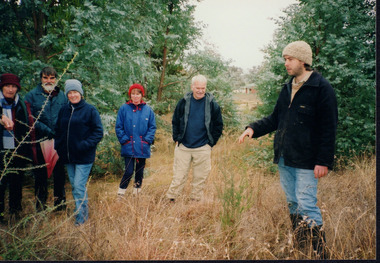 Wooragee Landcare Group
Photograph, 20th June 2004
Photo shows, (L-R): Lesley Finedon; unknown; Mary Prowse; Ann Henderson; Ray Henderson; Luke Bayley (North East CMA), assessing successful stream side rehabilitation at Bev DeJong and Bob Dunnett's place during a paddock demonstration and tree planting field day, called 'Really Successful Tree Planting!' run by Wooragee Landcare on Sunday 20th June 2004. Maintaining and reforesting native trees, shrubs and grasses are really important for a variety of reasons, including creating native habitat and food for birds and other animals, shade, biodiversity, visual appeal, cooling, shade for urban areas, sequestering carbon and conservation among other considerations. The planting must be consistent with the particular needs of the environment, such as trees or shrubs which would naturally occur and are native to the area. Tree planting demonstrations such as this one run by the Landcare Group ensures that the projects are being managed consistently with an overarching commitment to land protection and management and the best methods for best outcomes are employed.This photograph is significant as it provides evidence of a project undertaken by the Wooragee Landcare Group to educate themselves and members of the public on successful techniques needed to plant and maintain trees for replanting in the Wooragee area. The Wooragee Landcare Group has been instrumental in the co-ordination of programs relating to biodiversity protection in the local area, providing great assistance to landholders.WAN NA 0ANAON0 ANN+ 1 1636 / [PRINTED] (No.20) / 934wooragee landcare, wooragee landcare group, beechworth, landcare group, wooragee, tree planting, successful tree planting, demonstration, paddock demonstration, tree planting field day, really successful tree planting, land protection and management, land management, native trees, conservation -
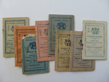 Warrnambool and District Historical Society Inc.
Document - Warrnambool. Woodford. Winslow. Purnim Race Books, Modern Print, W’Bool, Victoria, 1920's and 1930's
The Warrnambool Amateur Turf Club was first formed in September 1859, but didn't become a properly constituted club until April 1873, when a meeting was held at the Commercial Hotel, now the Whaler's Inn, and a committee was elected.Part of the present racecourse of 100 acres was set aside as a racing and recreation reserve in August 1855. It is one of the finest racecourses in Australia, ringed by the gentle slopes of a huge basin.The first race meeting was held on the course in August 1858. The Warrnambool Racing Club has managed racing at Warrnambool since it was formed on 5 April 1873.Apart from a number of smaller meetings held throughout the year, the feature of racing in the district is the Grand Annual Steeplechase. The first steeplechase over the now famous cross-country course was run on 13th June 1872 then known as the Grand Annual Steeplechase. The paddocks now know as Brierly and Granters were first used on that date. The course, over four miles, was made up of different kinds of jumps including a stone wall, a log fence, a ditch and parapet, a paling fence and numerous post and rails. The name Grand Annual was first used for this steeplechase in May 1895. It is the longest horse race in Australia, and the thirty three fences of the course, the most of any steeplechase in the world is raced over 5,500 metres. The three day May racing carnival is the major racing event on the horseracing and social calendar. Many of these race booklets relate to those May meetings. The Warrnambool Racecourse has been the home of district racing clubs such as Woodford, Purnim and Koroit over the latter part of the 20th century. The Woodford Racing club holds their annual meeting after Christmas each year. The Winslow races were held from approximately mid-19th century to around 1946. It began as a small picnic race club in Tobin’s paddock to a splendid race course on the property, “Green Hills” owned by Mr. John O’Keefe about one mile north of the Winslow township.. The annual meetings held on New Year’s Day drew crowds of seven to eight thousand people. All of these books contains family names which in some cases are still strongly linked to horse racing in the district.These booklets are a tangible link to a great sporting and social event in the Western District. A collection of programmes for race meetings. They relate to Warrnambool, Woodford, Purnim, Winslow and Victoria Racing Club meetings in the period 1922 to 1931. All are soft card covers with approximately 16 pages in each in white paper. They are numbered as follows: 001250.1 WRC Soft green cover with blue text 01/05/1923 001250.2 WRC Mauve cover with blue text 03/05/1923 001250.3 WRC fawn cover with red text 06/05/1924 001250.4 WRC Orange cover with blue text 08/05/1924 001250.5 WRC Soft green cover with light brown text 05/05/1925 001250.6 WRC Soft green cover with red text 07/05/1925 001250.7 WRC fawn cover with brown text 04/05/1926 001250.8 Woodford racing Club soft pink cover, Blue text 01/04/1922 001250.9 Woodford racing Club green cover, Blue text 07/04/1923 001250.9 Woodford racing Club grey cover, Blue text 05/04/1924 001250.10 Woodford racing Club grey cover, Blue text 05/04/1924 001250.11 Woodford Racing Club green cover, Blue text 22/11/1924 001250.12 Woodford Racing Club green cover, brown text 04/04/1925 001250.13 Woodford Racing Club orange cover, blue text 10/04/1926 001250.14 Woodford Racing Club pink cover, green text 10/04/1926 001250.15 Warrnambool Racing Club pink cover, blue text 18/11/1922 001250.16 Warrnambool Racing Club pink cover, red text 13/11/1926 001250.17 Warrnambool Racing Club cream cover, brown text 15/11/1924 001250.18 Warrnambool Racing Club cream cover, green text 18/01/1922 001250.19 Warrnambool Racing Club grey cover, blue text 15/01/1924 001250.20 Warrnambool Racing Club cream cover, blue text 13/01/1925 001250.21 Warrnambool Racing Club pink cover, blue text 15/01/1925 001250.22 Warrnambool Racing Club olive green cover, blue text 12/01/1926 001250.23 Warrnambool Racing Club blue cover, blue text 14/01/1926 001250.24 Warrnambool Racing Club soft green cover, blue text 13/01/1931 001250.24 Warrnambool Racing Club orange cover, black text 16/01/1930 001250.25 Warrnambool Racing Club orange cover, black text 16/01/1930 001250.26 Purnim Racing Club green cover, blue text 19/05/1924 001250.27 Winslow Racing Club pink cover,black text 21/04/1923 001250.28 Winslow Racing Club green cover,black text 06/12/1924 001250.29 Victoria Racing Club cream cover,green text 11/07//1923 001250.30 Victoria Racing Club cream cover, red text 14/07//1923 Most of the booklets have markings with place getters and jockeys marked in pencil. Warrnambool Racing club books have R U Forbes, C T Alexander A H Davies and William White as secretaries. Woodford club has Thomas Gleeson as secretary, Winslow 's secretary is W Latta and Purnim is P J Kelly. The local booklets are printed by The Modern Print Co Koroit St Warrnambool.warrnambool, warrnambool racing club, winslow racing club, woodford racing club, purnim racing club, victoria racing club -
 Otway Districts Historical Society
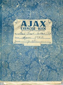
Minute Book, Beech Forest Football Club, Minutes, Balance Sheet, 1948-54, 1948
Beech Forest first entered the association prior to World War 1, playing in maroon and gold on a ground situated 200 metres north of the final ground. Little is known of the competition in those days. The Club reformed in 1921. Beech Forest changed its colours to Richmond colours and used a ground south of the township, now known as the Football Break Road in the Forest Commission pine plantation. In 1922 the site of the present ground had been purchased but it was 1929 before it was first used, and it was used every year, except 1953 when G. Bellchamber's paddock was used while major renovations were carried out on their home ground. It was in the same year, 1929, that they changed their colours yet again to the blue with white V colours, which they retained until the Club disbanded. Beech Forest won premierships in 1924 and 1940. In 1945 the Club reformed yet again to enter the Otway Association. They were successful in winning premierships in 1946, 1947, 1952 and 1953. Finally, in 1957, the Club disbanded to become part of the Otway Rovers Football Club.Beech Forest Football Club, (1) Annual Meeting and Ordinary Meeting Minutes, November 1948 - September 1952; (2) Annual Meeting and Ordinary Meeting Minutes March 1953 - April 1954, Statements of Receipts and Expenditure 1950 - 1952. 2x Exercise Book.Insert: Grounds used; Best and Fairest Players.beech forest; football; minutes; -
 Surrey Hills Historical Society Collection
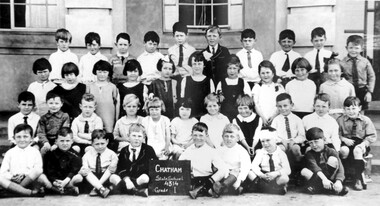
Photograph, Chatham State School Grade 1 1927, 1927
Chatham School, located in Weybridge Street Surrey Hills, was opened on 1 August 1927 following pressure from local residents as nearby schools (Balwyn, Mont Albert & Surrey Hills) were all over-crowded. This followed a surge in development following WW1. Land in surrounding streets was sub-divided. This included part of John Butler Maling (Jnr)'s small farm bounded by Banool Road, Wharton Road, Weybridge Street and Whitehorse Road. An area surrounding his home, 'The Willows' was retained and not sold until after he died in 1931. leased by Mr John Butler Maling in 1861. Three acres of his land were purchased by the Education Department. Some of the early students have referred to Chatham’s land as Mr Maling’s bull paddock. Some of the original yellow box trees remain on the property. The most significant of these is now called the Friendship Tree. On 1 August 1927 212 students were enrolled; Ralph Rae was one of these. The school was official opened on 15th February 1928. The school number is 4314. A black and white photograph of a group of 39 Grade 1 students from Chatham State School.1927, schools, chatham state school, clothing and dress, primary schools, john butler maling (jnr), ralph rae (mr) -
 Surrey Hills Historical Society Collection
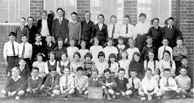
Photograph, Chatham State School Grade 5 1931, 1931
Chatham School, located in Weybridge Street Surrey Hills, was opened on 1 August 1927 following pressure from local residents as nearby schools (Balwyn, Mont Albert & Surrey Hills) were all over-crowded. This followed a surge in development following WW1. Land in surrounding streets was sub-divided. This included part of John Butler Maling (Jnr)'s small farm bounded by Banool Road, Wharton Road, Weybridge Street and Whitehorse Road. An area surrounding his home, 'The Willows' was retained and not sold until after he died in 1931. leased by Mr John Butler Maling in 1861. Three acres of his land were purchased by the Education Department. Some of the early students have referred to Chatham’s land as Mr Maling’s bull paddock. Some of the original yellow box trees remain on the property. The most significant of these is now called the Friendship Tree. On 1 August 1927 212 students were enrolled; Ralph Rae was one of these. The school was official opened on 15th February 1928. The school number is 4314. A black and white photograph of a group of 51 Grade 5 students from Chatham State School.schools, chatham state school, clothing and dress, primary schools, john butler maling (jnr), ralph rae (mr) -
 Victorian Interpretive Projects Inc.
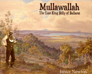
Book, Janice Newton, 'Mullawallah: The Last King Billy of Ballarat' by Janice Newton, 2015
Dr Janice Newton has had a long term interest in Indigenous Studies and Aboriginality, and has published papers linking Aboriginality to the counterculture and to artists and musicians. She has published a paper commenting on Ballarat's response to the death in 1896 of King Billy, the so called 'last of his tribe'. Janice has recently taught courses on 'The Anthropology of Indigenous Art' and 'Indigenous History' at Federation University Australia.56 page soft covered booklet outlining the life of Ballarat's Mullawallah (also known as King Billy or Frank Wilson). Numerous photographs. The book 'Mullawallah: The Last King Billy of Ballarat' is an initiative of Victorian Interpretive Projects. It is available for purchase for $15.00 (additional for postage). Please email [email protected] for further details. Images include: Ercildoun, Lake Burrumbeet, Lal Lal Falls, William Buckley, Warrenheip, King Billy and his Camp in McCree's Paddock, King Billy and His Tribe, Carl Walter King Billy, Mary of Carngham, Rosa of Carngham, King Billy (Bullip Bullip), Queen Mary of Buninyong, Queen Marie of Ballarat, Queen Mary and King Billy and their original mia mia, Football at Ercildoune, Thomas Jerusalem, Samuel Wilson, Frank the last of the Ballarat Tribe, The Burial of King Billy, King Billy's Grave. mullawullah, frank wilson, king billy, aborigines, wathauwrung, wadawurrung, aboriginal, ercildoun, ercildoune, lake learmonth