Showing 3677 items
matching gold mininging
-
 Bendigo Historical Society Inc.
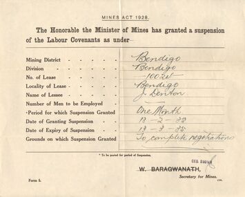
Document - MCCOLL, RANKIN AND STANISTREET COLLECTION: SUSPENSION OF LABOUR COVENANTS
... Gold Mining... Gold Mining Coy N.L., Gold Dumps Pty Ltd, Huntly & Nerring.... Mining Suspension of Labour Covenants Gold Mining Suspension ...18 large forms (form 5) headed: Mines Act 1928, The Honorable the Minister of Mines has granted a Suspension of the Labour Covenants as under - . These were granted to various companies for a period of 1 to 3 months, some of the reasons being - to complete negotiations, to raise capital, to re-organise, and the lease is held on behalf of a London Company. Items date range from 1941 to 1942. Some of the places to which these apply are; Bendigo, South Wattle Gully Coy N.L. Castlemaine Vic 3450, Central Wattle Gully Coy N.L., North Hustlers G. M. Coy N.L., Elphinstone, Chewton, South Wattle GullyCoy N.L.,Sandhurst, Forbes Carshalton Gold Mining Coy N.L., Gold Dumps Pty Ltd, Huntly & Nerring.Government Printergold, mining, suspension of labour covenants, gold mining, suspension of labour covenants -
 Bendigo Historical Society Inc.
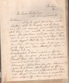
Administrative record - Garden Gully and Moon Extended Gold Mining Company, Manager's Report Book, 1934 - 1935
... Garden Gully and Moon Extended Gold Mining Company...Garden Gully and Moon Gold Mining Company..., addressed to the Garden Gully Moon Gold Mining Company with details... Gully and Moon Gold Mining Company Blue hard cover book, red ...Blue hard cover book, red binding on spine, one hundred and eighty eight pages of which forth eight are used. White label on front cover, no name of Company recorded. Inside front cover, affixed to front page, is a letter from Alfred Jorgensen, addressed to the Garden Gully Moon Gold Mining Company with details of his visit to the mine site at Sebastian; further letter affixed to page 2. Subsequent pages contain hand written Mine Manager's reports, by L.C. Bentley, dating from 21st December through to June 19th, 1935. Further reports by Alfred Jorgensen (pages 17 and 19) are inserted in the book. Mine Manager's book forms part of the Margaret Roberts Collection of Mining records.bendigo, margaret roberts, mccoll, sebastian, l.c. bentley, alfred jorgensen, rankin and stanistreet, legal managers, garden gully and moon gold mining company -
 Melbourne Tram Museum
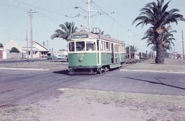
Slide, Keith Caldwell, 12/03/1960 12:00:00 AM
... . The house with the red guttering is one that dates back to the gold... to the gold mining era. See http://www.esshissoc.org.au/1070%20Mount ...Agfa Colour slide, cardboard mount, by Keith Caldwell dated 12 March 1960, of W5 818 running in Mount Alexander Road, North Essendon, crossing the street access for Marco Polo Street. The tram showing route 59, Essendon Aerodrome, has trolley wheels and has a second person in the cab, possibly a trainer. Unusually the tram number is placed above the headlight, In the background are the palm trees in the centre median plantation. The house with the red guttering is one that dates back to the gold mining era. See http://www.esshissoc.org.au/1070%20Mount%20Alexander%20Road.pdf It was relocated to Woodland Park during 2017? Note the Centre poles, overhead construction and street light. Also in the background is a Mobil Service station that later became a garden centre. Now a block of apartments.hand stamped "12 Mar '60"trams, tramways, mount alexander rd, north essendon, essendon airport, essendon aerodrome, route 59, w5 class, tram 818 -
 Federation University Historical Collection
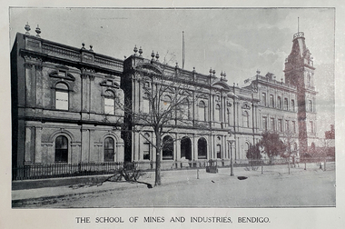
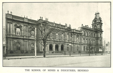
Booklet - Booklet - Prospectus, Cambridge & Leaney Printers, Bendigo Junior Technical School, School of Mines, Prospectus 1913, 1913
... gold fields. Mining, chemistry, geology, metallurgy and art... and technical needs of the mining industry on the local gold fields ...The Bendigo School of Mines was opened in 1873 to meet the scientific and technical needs of the mining industry on the local gold fields. Mining, chemistry, geology, metallurgy and art were taught. In c.1907 a Junior Technical School commenced to operate at the School of Mines and Industry. This was to enable boys who had completed primary school the opportunity to continue their education and learn skills to assist them in their future. In c.1961 the Junior Technical School ceased to operate with that function being transferred to the White Hills and Kangaroo Flat technical schools.Red/brown soft covered booklet.A.W Steane written on front coverbendigo junior technical school, prospectus, w.h walter, j.r.v anderson, a.w. steane, w.s. lake, k.c. abbott, mr grant, mathematics and science, woodwork and sheet metal, art, principal, bendigo -
 Federation University Historical Collection
Booklet, Cambridge Press Bendigo, Bendigo Junior Technical School Prospectus, 1914, 1914
... gold fields. Mining, chemistry, geology, metallurgy and art... and technical needs of the mining industry on the local gold fields ...The Bendigo School of Mines was opened in 1873 to meet the scientific and technical needs of the mining industry on the local gold fields. Mining, chemistry, geology, metallurgy and art were taught. In c.1907 a Junior Technical School commenced to operate at the School of Mines and Industry. This was to enable boys who had completed primary school the opportunity to continue their education and learn skills to assist them in their future. In c.1961 the Junior Technical School ceased to operate with that function being transferred to the White Hills and Kangaroo Flat technical schools.Grey soft covered booklet with green printing. The prospectus outlines preparatory courses in Trade, Art and Science. Photographs include Physical Culture, Geometrical Development, Science Laboratory, Design, Sheetmetal, Woodwork and Modelling.Handwritten on front Cover A.W. Steanebendigo junior technical school, prospectus, head master, a e tutton, mathematics and science master, j a donald, woodwork and sheet matal, h f day, crafts master, k c abbott -
 The Beechworth Burke Museum
Audio - Oral History, Mrs Frances Gladstone, 31st March 2000
... Huntsman', which she wrote while watching her husband gold mining... Huntsman', which she wrote while watching her husband gold mining ...Frances Gertrude Gladstone was born on the 18th of September 1919 to Arthur George Ladson and Gertrude Hunrick Irving. France's grandfather, Alfred Ladson, came Beechworth from Norfolk, England, during the gold rush. Alfred had a grocery business, and was well known for writing letters for the miners to send to their families. Alfred also travelled to Beechworth with his sister, who was a trained nurse and helped establish a hospital for the goldfields. Frances remembers her father saying the Chinese miners were not allowed to bring their families to the goldfields, hence there were no Chinese children in schools around Beechworth. Frances was an avid botanist, and wrote a book called 'The Little Huntsman', which she wrote while watching her husband gold mining. This oral history recording was part of a project conducted by Jennifer Williams in the year 2000 to capture the everyday life and struggles in Beechworth during the twentieth century. This project involved recording seventy oral histories on cassette tapes of local Beechworth residents which were then published in a book titled: Listen to what they say: voices of twentieth century Beechworth. These cassette tapes were digitised in July 2021 with funds made available by the Friends of the Burke.Frances Gladstone's story is significant, as she remembered important information about Chinese miners in the gold rush, explained the role of women in the 20th century in Beechworth, and the history of the hospitals in the region. This is a digital copy of a recording that was originally captured on a cassette tape. The cassette tape is black with a horizontal white strip and is currently stored in a clear flat plastic rectangular container. It holds up 40 minutes of recordings on each side.listen to what they say, beechworth, oral history, burke museum, botanist, chinese miners, goldmining, gladstone -
 Bendigo Historical Society Inc.
Booklet - Fortuna Villa Tour Guide, abt 2013
... successful in his gold mining interests and investments. With his... in his gold mining interests and investments. With his continuing ...In 1871, the Villa and the associated ‘180 Mine’ on the New Chum Reef was bought by George Lansell who had become successful in his gold mining interests and investments. With his continuing success in deep mining, Lansell undertook major extensions to his home, and in fact continued this expansion and decoration of Fortuna until his death almost 40 years later. Fortuna Villa remains remarkably intact as a house even though it has served as a busy workplace for 65 years. Stained glass, elaborate ceilings, grand cedar and blackwood staircase, solid marble baths, extensive acid-etched glasswork (conservatory) are some of the architectural features that contribute to the outstanding ‘feel’ of the structure. The Fortuna grounds cover some 7.57 ha. and feature an ornamental lake, garden, a ‘Roman-Bath’ and the ‘Pompeii Fountain’. The original quartz-crushing battery building, stables and coach house remain close to the main villa. The magnificent villa itself is the aspirational centerpiece to this remarkable property. It is set in botanic-style gardens featuring established trees. George Lansell’s historic talisman has hosted some iconic characters itself, including leaders and diplomats, Dame Nellie Melba and even HRH the Prince of Wales and the Duke of Edinburgh.Fortuna Villa Tour Guide, seven pages - Photos, History and guide with description for each room or aspect. Chronology on back cover.history, bendigo, fortuna, george lansell -
 Bendigo Historical Society Inc.
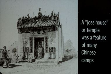
Slide - DIGGERS & MINING. GOLD, c1850s
... DIGGERS & MINING. GOLD...Diggers & Mining. Gold. Slide si of a 'joss house... EDUCATION Tertiary goldfields hanimount Diggers & Mining. Gold ...Diggers & Mining. Gold. Slide si of a 'joss house' with some Chinese people outside and one in the doorway. A 'joss house' or temple was a feature or many Chinese camps. Markings: 14 994.GOL. Used as a teaching aid.hanimounteducation, tertiary, goldfields -
 Bendigo Historical Society Inc.
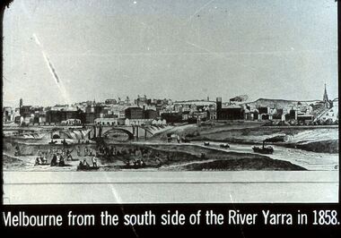
Slide - DIGGERS & MINING. THE GOLD ERA, c1850s
... DIGGERS & MINING. THE GOLD ERA...Diggers & mining. The gold era. Melbourne from the south... EDUCATION Tertiary goldfields hanimount Diggers & mining. The gold ...Diggers & mining. The gold era. Melbourne from the south side of the River Yarra in 1858. Markings 48 994.031 GOL:5. Used as a teaching aid.hanimounteducation, tertiary, goldfields -
 Bendigo Historical Society Inc.
Slide - DIGGERS & MINING. THE GOLD ERA, c1850s
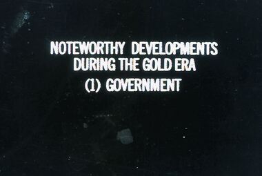
... DIGGERS & MINING. THE GOLD ERA...Diggers & mining. The gold era. Noteworthy Developments... EDUCATION Tertiary goldfields hanimount Diggers & mining. The gold ...Diggers & mining. The gold era. Noteworthy Developments During The Gold Era (1) Government. Markings 33 994.031 GOL:5. Used as a teaching aid.hanimounteducation, tertiary, goldfields -
 Bendigo Historical Society Inc.
Slide - DIGGERS & MINING. THE GOLD LICENCE, c1860s
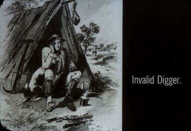
... DIGGERS & MINING. THE GOLD LICENCE...Diggers & Mining. The gold licence. The Government Camp... EDUCATION Tertiary goldfields hanimount Diggers & Mining. The gold ...Diggers & Mining. The gold licence. The Government Camp. Invalid Digger. Markings: 48 994.LIF. 4. Used as a teaching aid. Used as a teaching aid.hanimounteducation, tertiary, goldfields -
Bendigo Historical Society Inc.
Document - GARDEN GULLY LINE OF REEF, LEASE BLOCKS 5360 AND 5361
... , immediately south of the Great Southern Gold Mining Company's workings... BENDIGO Mining garden gully line of reef mines James Stirling ...Two page document titled ' Report on lease blocks Nos. 5360 and 5361 Garden Gully line of reef, Bendigo. Produced by the Department of Mines 1899. The area described is about 'one mile and a quarter southeast from the centre of the city of Bendigo, immediately south of the Great Southern Gold Mining Company's workings and is intersected by two auriferous gullies ... Salomon's Gully and Derwenter's Gully'. The alluvial deposits, the Garden Gully line, the Great Souther Co.and old workings are discussed in the paper. A map of the Garden Gully line of reef is attached to the report, showing claimholders and mine names along that section of the reef. Mines named on the map: Great Southern Garden Gully United Ulster Londonderry Burrows Horwoods Sea Amalgamated Garden Gully United Victory and Pandora Unity Carlisle and Garden Gully and Passbye United Cornish United Koch's PioneerJames Stirling, Government Geologistbendigo, mining, garden gully line of reef mines -
 Bendigo Historical Society Inc.
Photograph - SOUTH BENDIGO BOWLING CLUB 1906
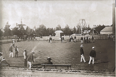
... and Summer Hill United Gold Mining company ( registered) on 2nd... BENDIGO Mining Cosmopolitan anfd summer hil united Copy of black ...Copy of black and white photograph, South Bendigo Bowling Club 1906. Men on bowling green, dressed in white trousers, dark blazers, straw bowler hats. The spire on LH side is the Congregational church, later a school in Olinda Street, Quarry Hill. Poppet head in background, RH side, is the Cosmopolitan and Summer Hill United Gold Mining company ( registered) on 2nd September 1870. Brick chimney on extreme RH side of photo. Mine not in image, but close by was the Palmerston. The mine was on the Sophia Reef, Manager George Wilsn Froggatt. Shareholders 1870: Robert Taylor, Ellen Taylor, Henry Hattam, Michael Cock, Robert Carr, William H. Casey, John McCrae, Joseph Millin, William Moran, Morton Hansen, George W. Froggatt, John A. Woodward, Robert Moorhead, William Nicholls.bendigo, mining, cosmopolitan anfd summer hil united -
 Bendigo Historical Society Inc.
Document - MCCOLL, RANKIN AND STANISTREET COLLECTION: INDENTURE GOLD MINING LEASE NO. 11145 CROWN AND NORTH DEBORAH MINING COMPANY, 14th February, 1941
... MCCOLL, RANKIN AND STANISTREET COLLECTION: INDENTURE GOLD...6 page document plus map : Gold mining lease No. 11145... document plus map : Gold mining lease No. 11145 between Crown ...6 page document plus map : Gold mining lease No. 11145 between Crown ( King George VI) and North Deborah Mining Company, Parish of Sandhurst, dated 14th February, 1941. Map: Lease No. 11145 'Mining District of Bendigo, County of Bendigo, Parish of Sandhurst. Total area 48 acres, 3 roods, 22 perches. Map has extensive colour key indicating depths below surface that will be mined. Crown land and surface excised shown in orange cross-hatching. Lease holdings on map: 10753, 11020, 1363 T.L., 1115 T.L., 11013, 11062, 11033, 9988. Dam shown on 11013. Railway line marked through centre of map. Map refers to central area of Bendigo and includes reference to Hargreaves Street, Violet Street, Lily Street, Breen Street and Sullivan Street.bendigo, mining, north deborah mining company, breen street, lilly street, hargreaves street, voilet street, sullivan street. -
 Bendigo Historical Society Inc.
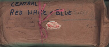
Document - MCCOLL, RANKIN AND STANISTREET COLLECTION: CENTRAL RED WHITE AND BLUE - BUNDLE OF PAPERS, 1912
... . 28 pages summary of gold mining correspondence - mortgage... ORGANIZATION Mining central red white and blue MCCOLL RANKIN ...Documents: Whitelaw Central Red White and Blue Mine Bendigo. 28 pages summary of gold mining correspondence - mortgage mining leases 943689340, contract of sale to Central Blue Gum GM 1933, leases with mining rights, treatment of pyrites agreement 1917 - J. Edwards & Co, Helen Streader - release of liability after being paid (pounds)125 by mine due to accidental death of husband 1912. Another for Ellen Lane 1916, list of titles held by Co , lease agreements Filcock and Manning, Andrew Harkness 'winding plant at mine' 1923, notice to perform agreement to Manning's 1916, Edwards Metallurgical Works 1917, map for 9777 Bendigo, contract for explosives with Dalgety & Co 1917, new scrip for lost shares 1917, Miner's Right 1911, sale of land Ra. A. Rankin 1910.MCCOLL RANKIN AND STANISTREETorganization, mining, central red white and blue, mccoll rankin and stanistreet. -
 Eltham District Historical Society Inc
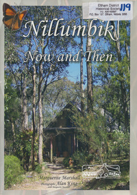
Book, Marguerite Marshall, Nillumbik now and then / Marguerite Marshall; photographs Alan King with Marguerite Marshall, 2008
... people, a former convict, farmers, a bushranger, gold-mining... people, a former convict, farmers, a bushranger, gold-mining ...Nillumbik Now and Then takes the reader on a journey from when the Aboriginal people were this area's sole inhabitnats, to the present day. Nillumbik's history - told in this collection of 96 stories, which are nearly all based on sites - mirrors those of the wider Australian community. It includes tales of the Wurundjeri people, a former convict, farmers, a bushranger, gold-mining, soldiers, artists, intellectuals, environmentalists and sportspeople. Each story is illustrated with a photograph. As a journalist with the former Diamond Valley News, Marguerite Marshall wrote a series of articles on local places of historic interest, later published as the small book "Eltham Shire - Historic Buildings and Places". Many years later an expanded version was published under the title "Nillumbik Now and Then". This is a much larger version of "Nillumbik Now and Then", including significant rewriting and many additional articles. The new publication was made possible by financial support from the Victorian Public Records Office, Bendigo Bank and Nillumbik Shire Council. EDHS and other historical societies in Nillumbik assisted with content for many of the stories. The book was launched at the Eltham Library on Wednesday 19th November 2008. Source: EDHS Newsletter No 183, November 2009 The front cover art depicts The former house of naturalist and artist Neil Douglas at Bend of Islands, photographer Marguerite Marshall. This collection of almost 130 photos and stories about places and people within the Shire of Nillumbik, an urban and rural municipality in Melbourne's north, contributes to an understanding of the history of the Shire. Published in 2008 immediately prior to the Black Saturday bushfires of February 7 2009, it documents sites that were impacted, and in some cases destroyed by the fires. It includes photographs taken especially for the publication, creating a unique time capsule representing the Shire in the early 21st century. It remains the most recent comprehenesive publication devoted to the Shire's history connecting local residents to the past. Paperback; x, 198 p. : ill., ports. ; 30 cm.Signed by the authornillumbik shire, houses, buildings, weller's hotel, landmarks, bend of islands -
 Ballarat Heritage Services
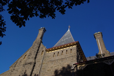
Photograph - Image - Colour, Clare Gervasoni, Bishop's Palace Ballarat Featuring Chimneys and Roof Line, Ballarat, 2014, 23/02/2014
... . This was on scale with the importance of Ballarat as a gold-mining centre.... This was on scale with the importance of Ballarat as a gold-mining centre ...Bishops Palace was built in 1877 as the home for the first Catholic Bishop of Ballarat. Designed by Melbourne architect, Joseph Reed, of Reed and Barnes, it was built by George Broom at a cost of £6,000. Reed and Barnes also designed Melbourne’s State Library, Ripponlea Estate and the Melbourne Royal Exhibition Building. The original heritage-listed gold lead stencilled paintwork that can be seen in the front entry and on the staircase walls at Bishops Palace was replicated in the Royal Exhibition Building. The original property was 140 squares set on 11 acres of gardens and took up an entire block of Sturt Street. This was on scale with the importance of Ballarat as a gold-mining centre at the time. Bishop's Palace is of architectural, aesthetic and historical significance to the State of Victoria. The two-storey bluestone mansion is an impressive example of 19th-century Gothic architecture with an unusual design. It retains many of its original features, including lead stencilled paintwork, cornices, ceiling roses, fixtures and fittings. Since sold by the Catholic Church the Bishops Palace has undergone a number of transformations in its lifetime, from the home of the first Bishop to a private residence, and today, as a luxurious accommodation, wedding and events venue. The grounds were subdivided over the years, and the property is now surrounded by four of the original 11 acres of gardens. It opened its doors to the public in 2019.Colour image of the bluestone Bishop's Palace, and it's cast iron lace.architecture, garden, bishop's palace, cast iron lace, cast iron, catholic church -
 Brighton Historical Society
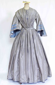
Clothing - Dress, Day dress, circa 1849
... of the gold mining era. The couple had seven children: John Campbell..., then Talbot at the height of the gold mining era. The couple had seven ...This dress was made for and belonged to Mrs Elizabeth McLachlan (nee Duncan, 1820-1904), wife of Reverend John Hamilton McLachlan (1813-1908), who was the first Minister of St Cuthbert's Presbyterian Church in Brighton. Elizabeth and John were married at the Free Church of Ayr at Lindsaystonn in the Parish of Kirkmickach, Ayrshire, Scotland on 15 October 1849. At this time his occupation was listed as "Minister of Presbyterian Church" and hers as "Governess". They left for Australia on the 1 November 1849 and arrived in Australia 6 months later. Apparently John's hair turned snow white during the journey due to his seasickness! The McLachlans first went to Geelong upon their arrival in 1850, then to the Western District, then Brighton, then Talbot at the height of the gold mining era. The couple had seven children: John Campbell Duncan McLachlan (b. Geelong, October 1850), Mary McLachlan (b. Geelong, November 1851), Agnes McLachlan (b. Hopkins River near Wickliff, May 1853), twins Elizabeth and Walter McLachlan (b. June 1854), Elizabeth McLachlan (b. Hesham, June 1855), Margaret McLachlan (b. Brighton, 1857). Elizabeth died in 1904. She and John are both buried in Amherst Cemetery. The dress was donated by one of her granddaughters. This circa 1849 silk blue grey window pane check dress features a high round neck and pleats on either shoulder extending over the natural shoulder line. The dress shows evidence of nine ornamental buttons down the centre front with only four blue silk buttons currently still attached. The dress fastens with thirteen concealed hook and eye closures to the waist. The Pagoda sleeves inset into the bodice in a small high armhole flaring out and finishing just below the elbow. A pale blue silk ribbon with a diagonal drawn stitch design decorates the front of the sleeve in a simple geometric design. The Pagoda sleeve is lined in a matching pale blue silk. The full skirt is pleated into the waistband and finishes just above the floor at the front. At the back the bodice features a squared off design to the princess panels shaping the dress into the body. The skirt is heavily pleated at the centre back into the waistline and finishes slightly longer at the back than the front. The skirt features two very small pockets on either side of the dress, just inside the hips. reverend john hamilton mclachlan, st cuthberts presbyterian church brighton, elizabeth mclachlan, amherst cemetery, 1840s fashion, brighton -
 Bendigo Historical Society Inc.
Document - MCCOLL, RANKIN AND STANISTREET COLLECTION: NEW STAR GOLD MINE HARRIETVILLE NL, 1935
... , agreement between New Star Gold Mining Harriet NL and Kong Meng Gold... Jeps ? Markings: pencil line through Gold Mining Lease No. 5187 ...McColl Rankin & Stanistreet, New Star Gold Mine Harrietville NL. a/ Agreement to purchase the mining operations and land at Black Snake Creek, Dargo, Mining District of Gippsland. For Mining Leases numbers 5187 & 5195, 31 acres. The purchaser Company is to be called Kong Meng Gold Reefs NL. Dated: 16/2/1935. Signed: J A Michelsen?, C Kingsley?, J Stanistreet, E R Grelis & ??? Inscriptions: Signed sealed and delivered by the said Ronald Alexander Rankin in the presence of E R Grelis. b/ Leasehold. Transfer of Land situated in the Parish of Dargo County of Dargo Mining District of Gippsland from New Star Gold Mine Harrietville NL to Kong Meng Gold Reefs NL. Dated: 12/3/1935. Signed: G ??, Geo ??, Stanistreet, G ??, Jamie Jeps ? Markings: pencil line through Gold Mining Lease No. 5187 change to a Leasehold Estate, line through January to be changed to March. c/ Indenture (copy of b/ with adjustments made) New Star Gold Mine Harrietville NL with Kong Meng Gold Reefs NL. Dated 13/3/1935. Signed: G ??, Geo ??, Stanistreet, G ??, Jamie Jeps ?, Stanistreet. d/ Carbon copy of a/. Signed: J A Michelsen?, C Kingsley?, J Stanistreet, E R Grelis & ??? Inscriptions: Signed sealed and delivered by the said Ronald Alexander Rankin in the presence of E R Grelis, J Stanistreet. e/ Indenture, agreement between New Star Gold Mining Harriet NL and Kong Meng Gold Reefs NL, was on the 9/3/1935 registered and Incorporated under the Companies act 1928 Part 2. Signed: E R Grelis, J Stanistreet, G ??, Geo ??, Stanistreet, G M?, Stanistreet. Dated: 12/3/1935.organization, business, gold mine, mccoll rankin & stanistreet new star gold mine harrietville nl black snake creek parish of dargo county of dargo mining district of gippsland mining leases numbers 5187 & 5195 kong meng gold reefs nl 1935 -
 Bendigo Historical Society Inc.
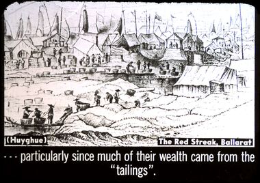
Slide - DIGGERS & MINING. GOLD, c1850s
... DIGGERS & MINING. GOLD...Diggers & Mining. Gold. (huyghue) The Red Street, Ballarat... EDUCATION Tertiary goldfields hanimount Diggers & Mining. Gold ...Diggers & Mining. Gold. (huyghue) The Red Street, Ballarat. . . . . particularly since much of their wealth came from the ''tailings''. Slide shows large Chinese camp and Chinese mining. Markings: 12 994.GOL. Used as a teaching aid.hanimounteducation, tertiary, goldfields -
 The Beechworth Burke Museum
Photograph, c.1870
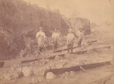
... for gold mining in the 1850s but became largely abandoned... Baarmutha. It was a popular area for gold mining in the 1850s ...This photograph was taken in approximately 1870 and depicts four male miners standing in mining sluice at the Three Mile Goldfields. These men are wearing typical attire for 1870s gold miners. They wear white shirts, tan coloured pants with water proof shoes and most of the men are wearing an apron to prevent their clothing from becoming too dirty from the mud. Each man is wearing a wide brim hat and hold large wooden tools used for sorting through the sluice. Three of the four men have full beards. The photograph was donated to the Burke Museum by R. Ziegenbein before 2001 but the photographer and the individuals captured in the photo are unknown. The image depicts the landscape of the Three Mile Goldfields during a period when open cut sluicing was undertaken to reach gold. Open cut sluicing is a method used to extract gold and other precious metals from beneath the surface of the earth. This technique involved the use of high-powered hoses which broke down the soil enabling miners to come along and search this soil for gold. After the gold rush of the early 1850s, diggers had to enlist the assistance of heavy machinery and techniques like hydraulic sluicing in order to reach gold because the surface alluvial gold had already been discovered and removed. This heavy machinery was not used until after 1853. The Three Mile Goldfields was a site of rich alluvial gold deposits located about 5 km south of Beechworth in Victoria. Today, the location of this gold deposit is called Baarmutha. It was a popular area for gold mining in the 1850s but became largely abandoned by the following decade. In 1865, a man named John Pund recognized that the area could be potentially rich if a better water supply could be obtained. He secured a 15 year license with three other miners. Within the next five years, these men had constructed 19 km of water race going from Upper Nine Mile Creek to Three Mile Creek. By 1881, these four men had delivered 950,000 gallons to the Three Mile Sluicing area which is depicted in this photograph. Pund was later go into partnership with John Alston Wallace who would become owner of the Star Hotel in Beechworth. The Three Mile sluicing location continued to be operational until 1950. Sluice box workers were a vital part of gold mining regardless of how inefficient they were in the recovery of gold. After using hydraulic sluicing to cut away the earth, miners would use the big wooden boxes depicted in the image to catch the earth which would then be sifted for gold. However, accidents would occur often which would result in the gold washing away and unable to be recovered. It was not a very efficient system because the gold, which was alluvial and thus very fine, would often pass through the sluice box undetected.The search for gold is ingrained into the history of Victoria and therefore, images like this one which portray an open cut sluicing site can reveal important information for society and technology for the date when the photograph was taken. This image is of important historical significance for its ability to convey information about sluicing and the methods used to find gold in the late 1800s and early 1900s. It also shows a location where sluicing was undertook which provides insight into the impact of sluicing on the environment at a time when it was done. Images, like this one, of Australian gold rush history can reveal important information about the social and environmental impact of this period. This image depicts diggers standing in a mining location and therefore, this image has the capacity to reveal or support significant information for researchers studying the fashion and social status of diggers in Australia in approximately 1870. It can also provide information on the landscape of Australia in this period and the impact of mining for gold on both society and the Australian landscape. The Burke Museum is home to a substantial collection of Australian mining photographs which can be used to gain a deeper understanding into life on the gold fields, technology used in mining, the miners themselves and the impact of the gold digging on the environment.Sepia toned rectangular photograph printed on matte photographic paper and mounted on board.[illegible] about 1870 / 97 2514.1 / 2594 30three mile goldfields, goldfields, 1870, 1870 gold, australia, australian landscape, miners, gold miners, diggers, gold diggers, beechworth, victoria, sluice box workers, sluicing, sluice, mining -
 Bendigo Historical Society Inc.
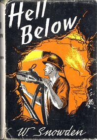
Book - HELL BELOW - LEADER, 1959
... 'Hell Below'. The romance of gold - fictional story...'. The romance of gold - fictional story of mining at Bendigo, told from ...'Hell Below'. The romance of gold - fictional story of mining at Bendigo, told from the viewpoint of a man who worked below. Reference to known mines and locations in Bendigo.W Snowdenbendigo, mining, conditions at the time. -
Tatura Irrigation & Wartime Camps Museum
Book, Deep Down
... edge of front cover and spine. Title in gold letters. Sketch... in blue around edge of front cover and spine. Title in gold ...Tatura Presbyterian Sunday School 3rd prize awarded to Edgar Mitchell, December 1917. Teacher Mrs Officer.Green hard cover book, decorative scrolling in blue around edge of front cover and spine. Title in gold letters. Sketch of mining scene. 416 pagespresbyterian sunday school prize, tatura presbyterian church, edgar mitchell, mrs officer -
 Bendigo Historical Society Inc.
Slide - DIGGERS & MINING. WALHALLA - GOLD TOWN, C1800s
... DIGGERS & MINING. WALHALLA - GOLD TOWN...Diggers & Mining. Walhalla - Gold Town. WALHALLA GOLD TOWN... DIGGERS & MINING. WALHALLA - GOLD TOWN ...Diggers & Mining. Walhalla - Gold Town. WALHALLA GOLD TOWN. Arial photo of Walhalla Gold Town. Markings: 2 995 WAL. Used as a teaching aid.hanimounteducation, tertiary, goldfields -
 The Beechworth Burke Museum
Photograph
... gold mining... until 1900. This Water Wheel was used in the gold mining... until 1900. This Water Wheel was used in the gold mining ...This photograph dates to 1899, towards the end of the gold rush in the Mopoke Gully area. A large opening to a mine can be seen behind the men in the photograph, with a wheeled cart on a track leading to the men's position, where the soil and rocks have been hauled away. This photograph interestingly contains dogs alongside the miners. While dogs have been recorded as deterrents to thieves in the Victorian goldfields, these dogs appear as companions to these men. Mopoke Gully mines came under the 'Fryer's Creek' division of the Castlemaine District during the Gold Rush. After the Gold Rush began in Victoria with the discovery of gold at Ballarat in 1851, Gold was found in Castlemaine by December of that year. 20,000 diggers were spread across the Castlemaine region, and the area was yielding about 23,000 ounces of gold per week. Mopoke Gully was the site of the Mopoke Gully Water Wheel, operating under the Bendigo and Fryers Goldmining Company from 1887 until 1900. This Water Wheel was used in the gold mining technique of 'sluicing'. Hydraulic sluicing uses high pressure water jets to blast away the earth, which runs through a sluice box, catching the gold with all remaining slurry washing away. This Water Wheel was built the same year as the more famous 'Chewton Water Wheel', but was smaller in diameter (60ft as opposed to Chewton's 72ft). The Mopoke Water Wheel ruins are quite intact today, and are a registered archaeological site. The search for gold is ingrained into the history of Victoria and therefore, images like this one can reveal important information for society and technology for the date when the photograph was taken. This image is of important historical significance for its ability to convey information about sluicing and the methods used to find gold in 1899. This photograph reveals important information on the use of dogs on Victorian goldfields in 1899. Dogs were used both as companions, such as this photograph depicts, as well as deterrents to thieves. Sepia coloured rectangular photograph printed on gloss photographic paper mounted on card. Obverse: Williams/ Good/ Luck Reverse: A02498/ 1997. 2498/ Good Luck/ Mine/ 1899/ Mopoke. beechworth, burke museum, gold, gold mining, 1899, castlemaine, mopoke gully, good luck mine, fryer's creek, gold rush, victorian gold rush, water wheel, sluicing, chewton -
 Bendigo Historical Society Inc.
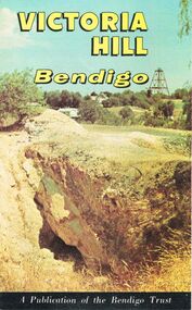
Photograph - Victoria Hill, Bendigo, 1973
... of Bendigo’s gold mining history and the importance that mining played... of Bendigo’s gold mining history and the importance that mining played ...Gold was discovered on Victoria Hill in 1854 and by 1861, 1,200,000 ounces of gold had been extracted from the site. The first claim was bought for 80 pounds by Prussian immigrant Christopher Ballerstedt and his son Theodore. Christopher Ballerstedt was nicknamed the "Father of the Hill" and was the first to prove that gold reefs extended below the surface. His 200-foot plus mine shafts yielded quartz rich with gold, inspired other miners, and were instrumental in Bendigo becoming the world's deepest and richest goldfield. The site still features relics of nineteenth century mining including quartz crushing machinery and the foundations of George Lansell’s 180 mine. These features are characteristic of Bendigo’s mining history and represent two prominent nineteenth century miners, Christopher Ballerstedt and George Lansell, who held important roles in the development of Bendigo. Victoria Hill Quartz Gold Mines are registered as a site of significance. The site is of historical, archaeological and scientific importance to Victoria. The mines represent the symbolic heart of Bendigo’s gold mining history and the importance that mining played in wealth creation and the development of Victoria. The diggings reserve is accessed from the rear of Albert Richardson Reserve located at 40-56 Marong Road, Ironbark. The site has steep and unformed paths and is closed to the public at dusk. It is important to stay to the paths to avoid the diggings. Interpretive signs help visitors to appreciate the importance of the site and the remaining relics of Bendigo’s mining history.Victoria Hill Ironbark, Bendigo. Photos of the poppet head, sand heap, tailings, shafts and tunnels. Before development into a tourist attraction.history, bendigo, victoria hill, ironbark, diggings -
 Bendigo Historical Society Inc.
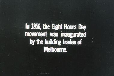
Slide - DIGGERS & MINING. THE GOLD ERA, c1856
... DIGGERS & MINING. THE GOLD ERA...Diggers & mining. The gold era. In 1856, the Eight Hours... EDUCATION Tertiary goldfields hanimount Diggers & mining. The gold ...Diggers & mining. The gold era. In 1856, the Eight Hours Day movement was inaugurated by the building trades of Melbourne. Markings 53 994.031 GOL:5. Used as a teaching aid.hanimounteducation, tertiary, goldfields -
 Bendigo Historical Society Inc.
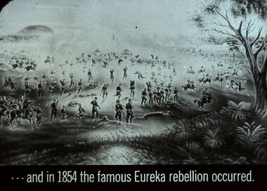
Slide - DIGGERS & MINING. THE GOLD ERA, c1850s
... DIGGERS & MINING. THE GOLD ERA...Diggers & mining. The gold era. - - - and in 1854... EDUCATION Tertiary goldfields hanimount Diggers & mining. The gold ...Diggers & mining. The gold era. - - - and in 1854 the famous Eureka rebellion occurred. Slide depicts a view of the rebellion. Markings 28 994.031 GOL:5. Used as a teaching aid.hanimounteducation, tertiary, goldfields -
 Bendigo Historical Society Inc.
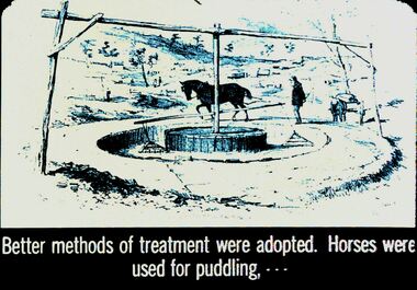
Slide - DIGGERS & MINING. THE GOLD ERA, c1850s
... DIGGERS & MINING. THE GOLD ERA...Diggers & mining. The gold era. Better methods of treatment... Diggers & mining. The gold era. Better methods of treatment were ...BHS CollectionDiggers & mining. The gold era. Better methods of treatment were adopted. Horses were used for puddling, - - - Markings 20 994.031 GOL:5. Used as a teaching aid.hanimounteducation, tertiary, goldfields -
 Bendigo Historical Society Inc.
Document - JOAN O'SHEA COLLECTION: VICTORIA HILL GOLDMINING AREA BOOKLET, March 1972
... Joan O'Shea Collection. Victoria Hill Bendigo Gold Mining.... Victoria Hill Bendigo Gold Mining on the Richest Quartz Reef ...Joan O'Shea Collection. Victoria Hill Bendigo Gold Mining on the Richest Quartz Reef in Bendigo, from 1854 to 1916. Colour and Black and White Booklet 16 Pages. Includes Maps of the Victoria Hill Area, photographs of the remains of a twenty head crushing battery, burnt ground from quartz roasting, The Victoria Quartz Mine Photograph from Australian Mining Standard June 1899, The compressor beds and concrete foundations for the poppet legs all that remain today of the Victoria Quartz Mine deepest mine on Bendigo Goldfield 4613 feet or 1406.04 metres. Also included photograph of the view of Victoria Hill from The New Chum Hill in the 1870s. The Location of the 3 mines Ballerstedt's open cut, North Old Chum and Lansell's 180 are marked. A depiction of Rae's Open Cut gives an understanding of the primitive nature of early workings on the Goldfields. The Booklet also provides a brief history of Victoria Hill itself.Bendigo Trust Publication March 1972. Printed in Bendigo Cambridge Press.bendigo, mining, victoria hill