Showing 14765 items
matching north road
-
 Whitehorse Historical Society Inc.
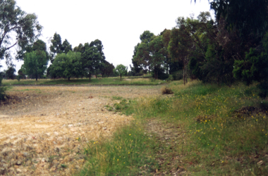
Photograph - Coloured photograph, Narmara Primary School, 13/01/1994 12:00:00 AM
... from North West corner. School on North side of Highbury Road.... School on North side of Highbury Road between Middleborough Road ...Coloured photo of Narmara Primary School, looking South from North West corner. School on North side of Highbury Road between Middleborough Road and Blackburn Road. Since demolished and site developed for housing.narmara primary school, warner, philip -
 Box Hill Historical Society
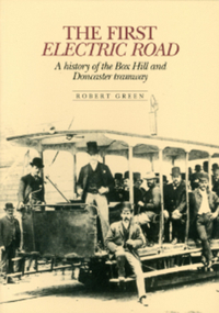
Book, Green, Robert, The First Electric Road - A History of the Box Hill and Doncaster Tramway
... Station Street north to Doncaster Road Intersection. Photos.... It ran from Whitehorse Road along Station Street north ...This book gives a brief description of tramways around the world before focussing on Box Hill-Doncaster's very own. The tramway - the first electric one in the Southern Hemisphere - operated from 1889-1896. It ran from Whitehorse Road along Station Street north to Doncaster Road Intersection. Photos. Index.arnot> arthur, draper> thomas, laurie> david, meader> william, masters> william, serpell> richard, glassford> matthew, aspinall> joseph w., cockcroft> george, collier> samuel, ellingworth> william, inglis> john, mcmurdie> f.a., padgham> silas, rawlings> alfred, serpell> alfred, wright> george, wright> james, wright> john, wright> william edward, lauer> a.c.h., transport, tram services, station street, box hill, elgar road, doncaster, doncaster road, box hill and doncaster tramway company -
 Eltham District Historical Society Inc
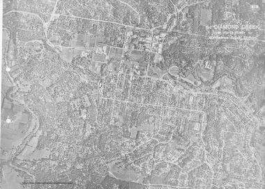
Photograph - Aerial Photograph, Landata, Eltham, Vic, Apr. 1972
... by Park Road to north, Mount Pleasant Road to south, Stokes... by Park Road to north, Mount Pleasant Road to south, Stokes ...Centred on present day Woodridge Estate, Eltham bounded by Park Road to north, Mount Pleasant Road to south, Stokes Orchard Estate to east and Eltham Railway Station to west. Historic Aerial Imagery Source: Landata.vic.gov.au Aerial Photo Details: Project No :985 Project : MELBOURNE 1972 Run : 27 Frame : 46 Date : 04/1972 Film Type : B/W Camera : RC10 Flying Height : 5700 Scale : 9600 Film Number : 2636 GDA2020 : 37°42'49"S, 145°09'46"E MGA2020 : 338053, 5824365 (55) Melways : 22 C5 (ed. 42)aerial photo, neil webster collection, 1972-04, eltham, eltham railway station, melway 22c5, mount pleasant road, park road, stokes orchard estate, woodridge estate -
 Whitehorse Historical Society Inc.
Map, Burwood Road, Box Hill City, 15/02/1952 12:00:00 AM
... Detailed map of subdivision along the north side of Burwood... Detailed map of subdivision along the north side of Burwood Road ...Detailed map of subdivision along the north side of Burwood Road, Box Hill between Station Street and Middleborough Road.Detailed map of subdivision along the north side of Burwood Road, Box Hill between Station Street and Middleborough Road. Shows many block owners, types of buildings, nature of fencing. Marked as 'Survey Plan No 5440'.Detailed map of subdivision along the north side of Burwood Road, Box Hill between Station Street and Middleborough Road. maps, burwood road, burwood, andrews street, greenwood street, tennyson street, middleborough road, station street -
Whitehorse Historical Society Inc.
Legal record - Land Title, Certificate of title
... Middleborough Road Blackburn North... in Middleborough Road Blackburn North and transfer of land from Chemical... for land in Middleborough Road Blackburn North and transfer of land ...Certificate of Title to Florence Mabel laurie for land in Middleborough Road Blackburn North and transfer of land from Chemical Plastics Limited to De Stoop (Aust) Pty Limited plus maps of some subdivisions of the estate, 1942.Certificate of Title to Florence Mabel laurie for land in Middleborough Road Blackburn North and transfer of land from Chemical Plastics Limited to De Stoop (Aust) Pty Limited plus maps of some subdivisions of the estate, 1942.Certificate of Title to Florence Mabel laurie for land in Middleborough Road Blackburn North and transfer of land from Chemical Plastics Limited to De Stoop (Aust) Pty Limited plus maps of some subdivisions of the estate, 1942.land titles, laurie, florence mabel, chemical plastics limited, de stoop (aust) pty limited, middleborough road blackburn north, koonung creek, chapman street blackburn north, vivian street blackburn north, nestor grove blackburn north, joseph street blackburn north -
 Whitehorse Historical Society Inc.
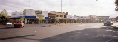
Photograph, Mitcham Shopping Centre, 1/11/2000 12:00:00 AM
... Coloured Photograph of Mitcham Shopping Centre - north side... Shopping Centre - north side of Whitehorse Road between Britannia ...Coloured Photograph of Mitcham Shopping Centre - north side of Whitehorse Road between Britannia Mall to Mitcham Road. Photograph taken from southern side of Whitehorse Road near the Post Office opposite Britannia Mall.mitcham shopping centre, whitehorse road mitcham, britannia mall, mitcham, mitcham road -
 Melbourne Tram Museum
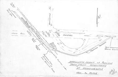
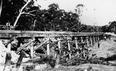
Drawing, Melbourne & Metropolitan Tramways Board (MMTB), "Modal Interchange Huntingdale Railway Station", 1973
... Shows North Road, railway line, railway station and possible... at Huntingdale" - dated 15/11/1973 Shows North Road, railway line ...Set of five foolscap sheets illustrating model interchange at Huntingdale Railway station to serve Monash University and further east. .1 - Photocopy of a sketch titled "Approximate layout of possible train tram interchange at Huntingdale" - dated 15/11/1973 Shows North Road, railway line, railway station and possible tram line. .2 - P14529 - Perspective of above, coloured, has figure 2 along the bottom edge. .3 - P14531 - sketch of a schematic layout at Huntingdale showing trains at either platform face along with a tram. Dated 7-12-1973. Has figure 2 along the bottom edge. .4 - P14545 - dated 11-11-74 - showing "Typical cross section Wellington Road for scheme D (Light rail)", showing the tramway in a trench possibly passing under Dandenong Road and other major intersections. has figure 8 along the bottom edge. .5 - P14523, dated 11-12-73 - showing a proposed loop into Monash University. Shows an extension to Ferntree Gully Station - See Reg Item 3807. Has figure 9 along the bottom edge.trams, tramways, huntingdale, north rd, new tramway, railways, wellington rd, monash university -
 Whitehorse Historical Society Inc.
Photograph, Mitcham Methodist Church
... just North of Whitehorse Road. In the late 1960's it was moved... just North of Whitehorse Road. In the late 1960's it was moved ...This is the oldest Mitcham Methodist Church and was initially situated on the corner of Richards Street and Whitehorse Road. It was then moved to a sight in Mitcham Road, Mitcham just North of Whitehorse Road. In the late 1960's it was moved to the Presbyterian site on the corner of East Doncaster and Whitehorse Roads, Mitcham. It is now (2005) used as a hall.Black and white photograph of the oldest Mitcham Methodist Churchmethodist church, mitcham -
 Eltham District Historical Society Inc
Work on paper (Sub-Item) - Aerial Photograph, Diamond Creek from Yarra River to Wattletree Road, Eltham
... Road, Bridge Street and Ryans Road, Eltham North ... River, Main Road, Bridge Street and Ryans Road, Eltham North ...Black and white aerial photograph witrh key features around the central place of Eltham township marked inluding Yarra River, Main Road, Bridge Street and Ryans Road, Eltham North land development, real estate, aerial view, eltham, eltham north -
 Whitehorse Historical Society Inc.
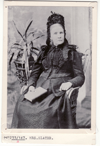
Photograph, Mrs. Slater
... Road, North Blackburn. When Mrs Slater died in 1895 the farm... was located in Blackburn Road, North Blackburn. When Mrs Slater died ...Mrs Slater and her husband William Slater migrated from Mitcham, Surrey, England in 1855 and established a herb farm in Nunawading - the first in Victoria. The farm was located in Blackburn Road, North Blackburn. When Mrs Slater died in 1895 the farm was sold. Slater Avenue and Slater Reserve is named for them.3 copies of Black and white photo of Mrs. Slaterslater, william, mrs, herb farms, slater avenue, blackburn north, slater reserve -
 Whitehorse Historical Society Inc.
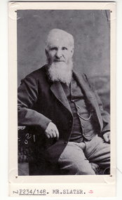
Photograph, William Slater
... Road, North Blackburn. When Mrs Slater died in 1895 the farm... was located in Blackburn Road, North Blackburn. When Mrs Slater died ...Mrs Slater and her husband William Slater migrated from Mitcham, Surrey, England in 1855 and established a herb farm in Nunawading - the first in Victoria. The farm was located in Blackburn Road, North Blackburn. When Mrs Slater died in 1895 the farm was sold. Slater Avenue and Slater Reserve is named for them.4 copies of black and white photo of William Slaterpioneers, slater, william, herb farms, slater avenue, blackburn north, slater reserve -
Whitehorse Historical Society Inc.
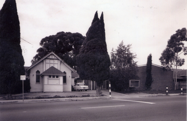
Document, History of Blackburn North State School No 4715, c1970
... on 5 acres of land on the North Side of Springfield Road...Whitehorse Historical Society Inc. 2-10 Deep Creek Road ...Document re establishment of Blackburn North Primary School on 5 acres of land on the North Side of Springfield Road. Opened 5 April 1954 with initial enrolment of 237 pupils, also listing staff and school committee members.blackburn north primary school, primary schools, jenkins, p, cole, j -
 Eltham District Historical Society Inc
Photograph - Aerial Photograph, Landata, Research, Vic, Apr. 1972
... Aqueduct and Eltham College bounded by Allendale Road to north... Aqueduct and Eltham College bounded by Allendale Road to north ...Centred on present day Main Road, Research near Maroondah Aqueduct and Eltham College bounded by Allendale Road to north, Research-Warrandyte Road to south, Swipers Gully Training Restaurant to east and Reynolds Road to west. Historic Aerial Imagery Source: Landata.vic.gov.au Aerial Photo Details: Project No :985 Project : MELBOURNE 1972 Run : 26 Frame : 194 Date : 04/1972 Film Type : B/W Camera : RC10 Flying Height : 5700 Scale : 9600 Film Number : 2636 GDA2020 : 37°42'07"S, 145°11'07"E MGA2020 : 340015, 5825692 (55) Melways : 22 H1 (ed. 42)aerial photo, neil webster collection, 1972-04, allendale road, eltham college, main road, maroondah aqueduct, melway 22h1, research (vic.), research-warrandyte road, reynolds road, swiper's gully -
 Eltham District Historical Society Inc
Photograph - Aerial Photograph, Landata, Eltham, Main Road; Mt Pleasant Rd to Railway Rd, Dec. 1945
... Road to north, Mount Pleasant Road at Main Road to south, top... Road to north, Mount Pleasant Road at Main Road to south, top ...Centred on Main Rd and Henry St, Eltham bounded by Railway Road to north, Mount Pleasant Road at Main Road to south, top of the hill in Arthur Street to east and Karingal Drive at Sherbourne Road to west. Historic Aerial Imagery Source: Landata.vic.gov.au Aerial Photo Details: Project No :65 Project : MELBOURNE AND METROPOLITAN PROJECT NO. 2 Run : 8 Frame : 70 Date : 01/1951 Film Type : B/W Camera : EAG9 Flying Height : 12200 Scale : 12000 Film Number : 1419 GDA2020 : 37°43'06"S, 145°08'45"E MGA2020 : 336589, 5823811 (55) Melways : 21 J6 (ed. 42)aerial photo, eltham, main road, henry street, arthur street, bolton street, eltham-yarra glen road, neil webster collection, 1951-01, dave lyon house, ernie andrew house, karingal road, melway 21j6, mount pleasant road, railway road -
 Eltham District Historical Society Inc
Photograph, Railway Bridge construction between Eltham and Hurstbridge, c.1912
... . This bridge is most likely near Allendale Road, Diamond Creek... in the stretch north of Allendale Road, which were all burnt out ...The railway was extended from Eltham to Hurstbridge in 1912. This bridge is most likely near Allendale Road, Diamond Creek. It was one of four original trestle bridges in the stretch north of Allendale Road, which were all burnt out in January 1969 (replaced by two steel bridges and two corrugated iron culverts).This photo forms part of a collection of photographs gathered by the Shire of Eltham for their centenary project book,"Pioneers and Painters: 100 years of the Shire of Eltham" by Alan Marshall (1971). The collection of over 500 images is held in partnership between Eltham District Historical Society and Yarra Plenty Regional Library (Eltham Library) and is now formally known as the 'The Shire of Eltham Pioneers Photograph Collection.' It is significant in being the first community sourced collection representing the places and people of the Shire's first one hundred years.Digital image One 4 x 5 inch B&W negative One 9 x 12.5 cm printshire of eltham pioneers photograph collection, hurstbridge, allendale road, hurstbridge railway extension, railway bridge, railway line construction, trestle bridge, diamond creek (creek) -
 National Wool Museum
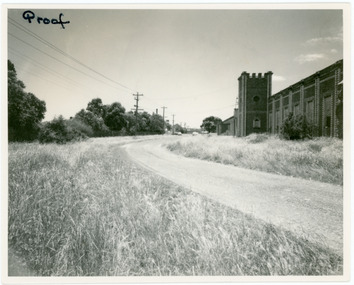
Photograph
... Depicts the west wall of the Barwon Mill, looking north..., looking north in Factory Road. The Barwon Mill was built in 1874 ...Depicts the west wall of the Barwon Mill, looking north in Factory Road. The Barwon Mill was built in 1874 and taken over by Godfrey Hirst and renamed Excelsior One in 1890. In 1966 McKendrick Consolidated Industries Ltd purchased Godfrey Hirst Ltd to operate a carpet manufacturing concern and this photo was taken at the time of the takeover.Proof IAN HAWTHORNE / PHOTOGRAPHER / Commercial, Portrait, Wedding, Colour Processor / Upstairs, 140 Moorabool St., Geelong Ph. 98096textile mills, godfrey hirst and co. pty ltd, barwon woollen mill, excelsior one mill -
 National Wool Museum
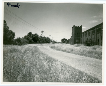
Photograph
... Depicts the west wall of the Barwon Mill, looking north..., looking north in Factory Road. The Barwon Mill was built in 1874 ...Depicts the west wall of the Barwon Mill, looking north in Factory Road. The Barwon Mill was built in 1874 and taken over by Godfrey Hirst and renamed Excelsior One in 1890. In 1966 McKendrick Consolidated Industries Ltd purchased Godfrey Hirst Ltd to operate a carpet manufacturing concern and this photo was taken at the time of the takeover.Proof IAN HAWTHORNE / PHOTOGRAPHER / Commercial, Portrait, Wedding, Colour Processor / Upstairs, 140 Moorabool St., Geelong Ph. 98096textile mills, godfrey hirst and co. pty ltd, barwon woollen mill, excelsior one mill -
 Brighton Historical Society
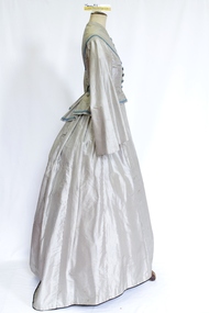
Clothing - Dress, Day dress, circa 1855-1872
... resident and the original occupant of the North Road mansion... and the original occupant of the North Road mansion 'Kamesburgh'. During ...This dress was donated as having belonged to Annie Elizabeth McLean, who worked as a maid to the daughters of Samuel Renwick of Caulfield. Annie was born in Argyllshire, Scotland in 1853. This dress appears to have been originally made circa 1855 and then modified circa 1872. As Annie would only have been two years old in 1855, this indicates that the dress would most probably have been originally made for someone else and later acquired by Annie. Annie Elizabeth McLean arrived in the Colony of Victoria from Argyllshire, Scotland with her aunts and cousins in 1867, aged thirteen and a half. She had been educated in Scotland and eventually became a personal maid and then companion to the Renwick girl, daughters of Samuel Renwick of Caulfield, Victoria. The Renwicks' home, 'The Garrell' on Glen Eira Road, was one of Caulfield's earliest residences, having been built around 1854. Samuel was a business partner of William Kerr Thomson, a well-known Brighton resident and the original occupant of the North Road mansion 'Kamesburgh'. During her time with the Renwick family, Annie travelled with them to England, then to Scotland, then back to Victoria. She left the family upon the marriage of the youngest Renwick daughter, then went to the household of Sir William and Lady McCullough until she left to be married to Alfred John Ashfold in 1878.This c1872 grey and white silk pin stripe dress features a high round neckline with eleven decorative blue silk buttons and secured by a concealed line of fifteen hook and eyelet closure. The bodice (.1) has decorative blue and green braid over the shoulder and bust and across the base of the bodice. The dress features three darts shaping the dress to the body. The sleeve is cut high but relatively full and tapers to the elbow then flares again in Pagoda like style but ends at the wrist or hand. The skirt (.2) opens over the left hip and features a pocket over the right hip. The skirt at the front finishes at the ankle or just above the ground. At the back the bodice features panels shaping the dress into the body and pleated and flared from the waist. At the small of the back is a decorative bow with pinked edges and decorative braid. The skirt at the back is uncommon in shape most likely as the result of modification. It appears to have had panels removed reducing its original fullness. It has a tape inside the back of the skirt that would draw the skirt in creating a bustle like shape . It would appear that the dress had been modified in order to create a more fashionable silhouette most probably in circa 1872. There are three separate pieces of fabric. One is made up into a semi-circular over-skirt trimmed with blue braid and fringing (.3). Two pieces are unpicked skirt gores, one still has its cotton lining attached (.4 and .5).annie elizabeth mclean, samuel renwick, the garrell, caulfield -
 Eltham District Historical Society Inc
Photograph, Research Shops precinct
... of Raglan Road and Main Road looking north east... Road and Main Road looking north east Research Shops precinct ...Two colour photographs in the vicinity of Research Shops: 1. At Main Road and Warrandyte Road roundabout looking south east towards the shops 2. At the north end of the shops at intersection of Raglan Road and Main Road looking north eastmain road, research, ingrams road, shops, roundabouts -
 Whitehorse Historical Society Inc.
Document, Canterbury Road Tunstall, 29/01/19?5
... and property valuation occupied by Mr Sliegner, north side... by Mr Sliegner, north side of Canterbury Road, Tunstall (Now ...Photocopy of letter to the Commercial Bank, Prahran re land and property valuation occupied by Mr Sliegner, north side of Canterbury Road, Tunstall (Now Forest Hill) close to Springvale Road. Land 2.5 acres with villa and out buildings.land values, sliegner (mr), canterbury road, forest hill, c. husband (estate agent) -
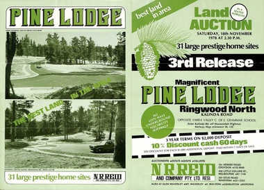 Ringwood and District Historical Society
Flyer, Land Auction Sale Brochure, Pine Lodge, Ringwood North, Victoria - 3rd Release 1978
... and services for Pine Lodge, Kalinda Road, Ringwood North - 3rd release... Road Ringwood North melbourne Refer also to Reg. No. 5171 ...Refer also to Reg. No. 5171 for Pine Lodge Land Auction previous release, 1977.Green tri-fold advertisement for auction of home sites, with map of subdivision, photographs, and summary of local features and services for Pine Lodge, Kalinda Road, Ringwood North - 3rd release - Auction date, Saturday, 18th November, 1978, at 2:30pm.Subdivision plan includes Mundara Drive, Bidston Court, Parkgate Drive, Frodsham Road, and Bebington Close. (Agent) N.R. Reid & Co. Pty. Ltd., 10A Hewish Road, Croydon (Phone) 725 0999, 450 Little Collins Street, Melbourne (Phone) 67 1746, and 207 Stud Road, Wantirna South (Phone) 221 2222. -
 Eltham District Historical Society Inc
Photograph - Aerial Photograph, Landata, Montmorency, Vic, Apr. 1972
... , Montmorency bounded by Meruka Drive to north, Main Road to south, Main..., Montmorency bounded by Meruka Drive to north, Main Road to south, Main ...Centred on present day Olympic Avenue at Grand Boulevard, Montmorency bounded by Meruka Drive to north, Main Road to south, Main Road to east and Alban Street to west. Historic Aerial Imagery Source: Landata.vic.gov.au Aerial Photo Details: Project No :985 Project : MELBOURNE 1972 Run : 28 Frame : 206 Date : 04/1972 Film Type : B/W Camera : RC10 Flying Height : 5700 Scale : 9600 Film Number : 2635 GDA2020 : 37°43'21"S, 145°07'46"E MGA2020 : 335154, 5823329 (55) Melways : 21 E7 (ed. 42)aerial photo, neil webster collection, 1972-04, eltham, alban street, grand boulevard, lower plenty, main road, melway 21e7, meruka drive, montmorency, olympic avenue -
 Eltham District Historical Society Inc
Photograph, Main Road, Lower Plenty at intersection of Old Eltham Road
... View looking north across the main road towards the Lower... melbourne View looking north across the main road towards the Lower ...View looking north across the main road towards the Lower Plenty shops showing the Lower Plenty Garage and store which was later developed into a Caltex service station, since demolished and replaced by a new Aldi supermarket.Black and white print Roll of 35mm colour negative film, 5 of 7 strips Kodak CP100 5094 and associated print Roll of 35mm black and white negative film, 3 strips Ilford FP4 and associated print Roll of 35mm colour negative film, 2 strips Kodak CP100 5094 and associated printaldi, caltex service station, lower plenty, lower plenty garage, lower plenty shops, main road, old eltham road, shops -
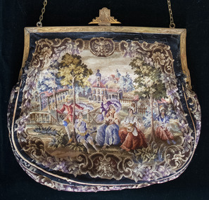 Brighton Historical Society
Bag, Evening purse, circa 1930
... resident of 59 North Road, Brighton. Born Alice Frances Mabel... welfare campaigner and longtime resident of 59 North Road ...This bag belonged to by Mrs Alice "May" Moss CBE (1869-1948), Australian suffragist, social welfare campaigner and longtime resident of 59 North Road, Brighton. Born Alice Frances Mabel Wilson in Ballarat, in 1887 May married Isidore Moss, the son of Norwood's builder Mark Moss. While her children were young, she began to campaign for the rights of women and served as vice-president of the Australian Women's National League in 1906-14, during which time she actively campaigned in Victoria for women's suffrage. She was an Australian delegate at the League of Nations Assembly at Geneva in 1927, where she was the first woman to sit on a finance committee. She attended the International Council of Women in Geneva in the same year and in 1928 was elected as vice president of the ICW, a position she held until her death. She was the first president of the National Council of Women of Australia, serving from 1931 to 1936. May was active in many other community organisations and causes, including the Royal Women's Hospital, the Collingwood Crèche and the Free Kindergarten movement. She served on the board of management of the City Newsboys' Society in 1906-48 and was the first woman lay-member of the National Health and Medical Research Council in 1936-45. She was also member of the International and Lyceum clubs, with an interest in the theatre, painting and woodcarving.French petit point tapestry bag featuring seven people in a bucolic scene, with trees and buildings in the background. Black border. Gold metal hinged opening with ornamental clasp and gold chain.may moss, petit point, 1930s -
Canterbury History Group
Photograph - Maling Road shops and environs, Stuart Warmington, 1993
... .1995.|Section E- Maling Road shops, north side - 27 coloured... Pigot in 1993.|Section B- Maling Road shops, north side - 88 ...Photographs recording interiors and exteriors of Canterbury shops, shopkeepers and Federation details of architecture. Section A -Maling Road shops, south side - 87 coloured photographs taken by Jan Pigot in 1993.|Section B- Maling Road shops, north side - 88 coloured photographs taken by Jan Pigot in 1993.|Section C- Bryson Street shops - car park - 4 coloured photographs taken by Jan Pigot in 1993-4.|Section D- Canterbury shops and streetscapes - 76 coloured photographs taken by Stuart Warmington c.1995.|Section E- Maling Road shops, north side - 27 coloured photographs taken by Stuart Warmington c. 1995.|Section F- Maling Road shops, north and south side - 24 coloured photographs taken by Stuart Warmington 1995.|Section G- Plaques and Signs in Canterbury - 14 coloured photographs taken by Jan Pigot c. 1994.maling road, canterbury, shops, shopkeepers, hel> f, petroro> tony, bourke> francis, d'annibale> grace, buckley> june, buckley> ken, godfrey, greengrocers, newsagents, gift shops, furniture restorers, florists, nurseries (plants), cake shops, cafes, butchers -
Surrey Hills Historical Society Collection
Postcard - Union Road, Surrey Hills looking north
... Union Road, Surrey Hills looking north... of the intersection of Union and Canterbury Roads looking north towards Mont... of Union and Canterbury Roads looking north towards Mont Albert ...Surrey Family Hotel (McNeill's Family Hotel) was built in 1888 by Alexander McNeill. It closed as a hotel after the Local Option vote in 1920.A colour post card from a watercolour sketch of the intersection of Union and Canterbury Roads looking north towards Mont Albert Road. It shows bluestone guttering edging the road in the foreground. Children are gathered under the verandah on the SW corner of the intersection and on the road. A horse drawn vehicle is seen travelling to the west down Canterbury Road. McNeill's Family Hotel, the Surrey Hall and part of Hansen's Terrace can be seen. Advertising signs for Otto Preuss (undertaker) and A R B Cuest (baker) can be partly seen. In the distance scattered houses and open space can be seen.Front: Printed on the post card "Union Rd. Surrey Hills, looking North" Rear: "BOX HILL HISTORICAL SOCIETY" (stamp) and "Mrs E W Zerbe / Williamson Rd. / Doncaster" in biro. This is possibly Marjorie Morgan's writing. "POST WTP (within cartouche) CARD" and "Printed / in / Germany" printed on card.mcneill's family hotel, bakers, undertakers, surrey hall, surrey theatre, rex theatre, mr a r b cuest, mr otto preuss -
 Whitehorse Historical Society Inc.
Photograph - Coloured Photograph, Narmara Primary School, 13/01/1994 12:00:00 AM
... . School on North side of Highbury Road between Middleborough Road... of Narmara Primary School looking East from North West corner ...Coloured photo of Narmara Primary School looking East from North West corner, showing site of removal of school buildings. School on North side of Highbury Road between Middleborough Road and Blackburn Road. Since demolished and site developed for housing.narmara primary school, warner, philip -
 Bendigo Historical Society Inc.
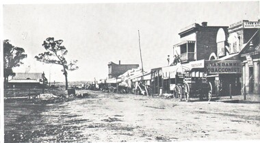
Photograph - HARRY BIGGS COLLECTION: BENDIGO PALL MALL, 1850's
... photo of Bendigo. Pall Mall area, looking north. The unmade... of Bendigo. Pall Mall area, looking north. The unmade road has a line ...Photograph. Harry Biggs Collection. Black and white photo of Bendigo. Pall Mall area, looking north. The unmade road has a line of shops to the right. - K Van Damme Tobacconist is in the foreground as is Cobb & Co booking office. Above the tobacconist is the sign Morey & Snow. 2 men are standing above a shop. Horse & carts are parked in front of the shops. Trees are to the left.place, building, commercial, harry biggs collection, bendigo pall mall -
 Eltham District Historical Society Inc
Photograph - Aerial Photograph, Landata, Eltham / Research, Vic, Jan. 1951
... , Eltham bounded by Maroondah Aqueduct to north, Nyora Road..., Eltham bounded by Maroondah Aqueduct to north, Nyora Road ...Centred on Brinkkotter Road opposite Yarramie Reserve, Eltham bounded by Maroondah Aqueduct to north, Nyora Road to south, Eltham College to east and Leane Drive to west. Historic Aerial Imagery Source: Landata.vic.gov.au Aerial Photo Details: Project No :65 Project : MELBOURNE AND METROPOLITAN PROJECT NO. 2 Run : 7 Frame : 8 Date : 01/1951 Film Type : B/W Camera : EAG9 Flying Height : 12200 Scale : 12000 Film Number : 1419 GDA2020 : 37°42'32"S, 145°10'41"E MGA2020 : 339408, 5824924 (55) Melways : 22 F3 (ed. 42)Historical aerial photos and photo maps provide viusal evidence of the chronology of changes to the built landscape of the district and assist in dating other imagesaerial photo, 1951-01, eltham, neil webster collection, brinkkotter road, eltham college, leane drive, maroondah aqueduct, melways 22f3, nyora road, yarramie reserve -
 Eltham District Historical Society Inc
Photograph - Aerial Photograph, Landata, Research, Vic, Apr. 1963
... Close, Research bounded by Maroondah Aqueduct to north, Nyora... Close, Research bounded by Maroondah Aqueduct to north, Nyora ...Centred on present day Thompson Crescent and Nicholson Close, Research bounded by Maroondah Aqueduct to north, Nyora Road to south, Eltham College to east and Eltham Gateway Hotel to west. Historic Aerial Imagery Source: Landata.vic.gov.au Aerial Photo Details: Project No :486 Project : MELBOURNE (1963) PROJECT Run : 5 Frame : 61 Date : 04/1963 Film Type : B/W Camera : RC8 Flying Height : 5100 Scale : 9600 Film Number : 1805 GDA2020 : 37°42'24"S, 145°10'06"E MGA2020 : 338528, 5825143 (55) Melways : 22 D3 (ed. 42)aerial photo, neil webster collection, eltham, 1963-04, eltham college, eltham gateway hotel and conference centre, maroondah aqueduct, melway 22d3, nicholson close, nyora road, research (vic.), thompson crescent