Showing 24981 items matching "north"
-
 Kew Historical Society Inc
Photograph - Kew Main Drain, 1984
'Kew, Kew East, Balwyn & Balwyn North are located approximately 7km north east of Melbourne. Four main stormwater drains service the area flowing from south to north. Three of the drains: Deepdene Drain; Balwyn Drain & Glass Creek converge in Kew East just west of Burke Road at Kew High School before discharging into the Yarra River. The fourth drain, Kew Main Drain connects directly with the Yarra River to the West of Glass Creek.' The Kew Main Drain is a barrel drain that was created in the 1930s, and follows the route of the former Connor's Creek from the vicinity of Genazzano FCJ College to the Yarra River in East KewImportant and verifiable evidence of the construction methods used by the Melbourne & Metropolitan Board of Works in building the Kew Main Drain, before its reconstruction in c.1985.Original print colour positive photograph of the Kew Main Drain, provided on 14/12.84 to the Chief Engineer of the City of Kew, Ian Poulter, by the Supervising Engineer (Works), Southern and Eastern Drainage, Melbourne & Metropolitan Board of Works. The record includes an image of the reverse as well as the donation document from the MMBW."A84/1855-10 / 750mm council drain looking U/S [up stream] from Parkhill Road, Kew."kew main drain, stormwater drains -- kew (vic.), connor's creek -- kew (vic.) -
 The Beechworth Burke Museum
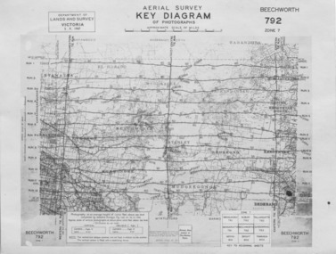
Photograph - Aerial Survey, 5/9/1947
This image is an Aerial Survey, Key Diagram of Beechworth and surrounding area. Issued by Department of Lands and Survey, Victoria in 1947. Photographed at an average height of 12300 feet above sea level, areas depicted are; Beechworth, Stanley, Bruarong, Baranduda, Muagegonga, Myrtleford, Everton, Wooragee North Tarrawinge, Dederang, Kergunyah North, Kergunyah, Yackandandah, El-Dorado, Barambogie, Murmungee, Barwidgee, Oxley, CarraragarmungeeBlack and white rectangular photograph. Image is printed on matt photographic paper and has a white un-printed border. Obverse: AERIAL SURVEY, KEY DIAGRAM OF PHOTOGRAPHS, APPROXIMATE SCALE OF MILES / DEPARTMENT OF LANDS AND SURVEY VICTORIA 5.9.1947. BEECHWORTH 792 ZONE 7. Reverse: BMM7010.1 (written in pencil) aerial survey, beechworth, burke museum, department of lands and survey, victoria, 1947 -
 Warrnambool and District Historical Society Inc.
Administrative record - Minute Book: Warrnambool North Technical School Ladies' Auxiliary, 1968
This is a Minute Book of the Warrnambool North Technical School Ladies' Auxiliary. The Minutes date from 29 May 1968 to 21 September 1977. The Warrnambool North Technical School was established in 1968 in Albert Park, Warrnambool. and continued until 1993 when it merged with Warrnambool High School to form Warrnambool College in 1994. The Ladies' Auxiliary was formed to provide greater educational facilities and amenities for the school.This Minute book is of some interest as a memento of the work of an auxiliary body connected with a Warrnambool school existing in the 20th century. This is a red hard covered Minute book with 144 lined pages with indented alphabetical tabs. The spine is torn.The Constitution is typewritten and there are hand written Minutes. There are some loose handwritten pages and some loose typewritten pages. COLLINS Minute Indexed 3880 SERIES MINUTE INDEX warrnambool, warrnambool north technical school, warrnambool north technical school ladies auxiliary -
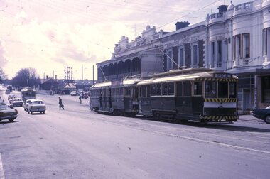
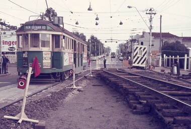
 Ballarat Tramway Museum
Photograph - Last tram across the Railway level crossing, 19/9/1971
Photograph - night flash - shows tram 42 crossing the Lydiard St level crossing with a large crowd on board. Tram has the destination of depot. Given the tram number and the crowd, most likely the last tram from Lydiard St North to the depot. Tram 42 was recorded as the last to leave Lydiard St North on 19/9/1971. Not known who took the photograph.Yields information about the last tram to cross the Ballarat Railway level crossing.Black and white photograph on plain paper.tramways, lydiard st north, level crossing, tram 42, last tram -
 Melbourne Tram Museum
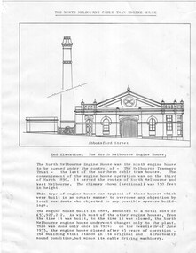
Drawing - North Melbourne Engine House, Jack Cranston
Drawing shows the North Melbourne cable tram engine house in Abbotsford St at Queensberry St, North Melbourne. Shows the elevation to Abbotsford St and the plan of the engine house showing the cable or rope layout and its function. Has notes on the engine house itself and costs etc. It operated from March 1890 to June 1935. Compiled by Jack Cranston for his book on cable trams.Yields information about the North Melbourne Engine house.Set of two printed quarto sheets.tramways, cable trams, engine houses, north melbourne, abbotsford st., queensberry st -
 Ballarat Tramway Museum
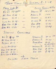
Document - Form/s, List, State Electricity Commission of Victoria (SECV), "Tram times for Sunday 2-3-58", "Application for permission to exchange duties", 1958
Demonstrates preparation of notes for tram operations and an actual use of the form used for change of shifts by crewsList - hand written sheet on the rear of the application form listing tram times from Lydiard St / Outer termini to city and the last trams, titled "Tram times for Sunday 2-3-58" Lists trams for Victoria St, Mt Pleasant, Sebastopol, Lydiard St North, Gardens via Sturt St West and Drummond North. Written in ink. Form - duplicated form S35 - "Application for permission to exchange duties", dated 19-2-58, for A Thompson (No. 63) to swap with C. Goldsmith (No. 39) on 22-2-58. Signed by both parties and authorised by the Traffic Inspector. Both in ink and pencil. Was attached to Reg Item 8027 trams, tramways, rosters, employees, forms, shifts, inspectors -
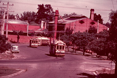
 Ballarat Tramway Museum
Slide - 35mm slide/s, Peter Moses, 21/08/1971 12:00:00 AM
Photo of SEC Ballarat No. 14 and possibly No. 42 (Briquette roof advertisement and features on the same special trams in Reg. item 2064) waiting in Lydiard St. North for the arrival of the ARHS special on Saturday 21/8/1971 to undertake the last tour of Ballarat Tramways, prior to the closure of the system. The first line closure (Victoria St.) took place the following day. Has Reid's Coffee Palace building in the background and other buildings on the east side of Lydiard St. North. Two other single truck cars in the photo as are the railway gates at the station. Kodak cardboard mount slide, taken by Peter Moses 21 August 1971.On back of slide in light black ink "N14 Ballarat / ARHS / 4 trams special Lydiard St" and "P. Moses" in black ink in the upper right hand side of the slide.tramways, trams, arhs, lydiard st north, railway crossing, tram 14, tram 42 -
 Ballarat Tramway Museum
Slide - 35mm slide/s, Max Michell, Mar. 1972
White cardboard mount, 35mm slide, from the Association of Railway Enthusiast's film strip titled "Provincial Tramway Film Strip" of Bendigo No. 5, 6 and 28 in bound in a convoy of Special trams on the North Bendigo route in Caledonia St. Has the Bendigo gas works in the background. Trams showing destination of Special. The film strip notes (Reg. Item 2560), provided the following caption details: "The three types of Bendigo car - Bogie No. 5, Single trucker No. 6 and Birney No. 28 - head away from "NORTH BENDIGO" in a special convoy. - Mar. '72 (Max Michell)" See image btm2590p.tif for high level scan of image. Stamped on base of slide "11800" and written in ink on top edge "No 5, 6 + 28 Nth Bendigo"tramways, trams, are, film strip, caledonia st, gas works, tram 6, tram 5, tram 28 -
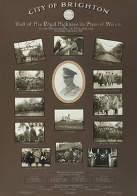 Bayside Gallery - Bayside City Council Art & Heritage Collection
Photograph - gelatin silver photograph, Visit of His Royal Highness the Prince of Wales to the Municipality of Brighton, 1920
In 1920 the Prince of Wales embarked on a journey to Australia on behalf of his father, King George V. While the visit was intended to strengthen the relationship between Australia and the Empire, the main objective was to offer thanks to the Australian men and women for the sacrifices and contributions that they had made during World War I. The Royal Tour began in April 1920 and covered 110 cities and towns across the country. The Prince spent eleven days in New South Wales, nine days in Victoria, four days in Tasmania, eleven days in Western Australia, six days in South Australia and eight days in Queensland. On Saturday 5 June 1920, following a morning at the races in Flemington, the Prince spent the afternoon at ANZAC Hostel in Brighton, where he chatted to wounded soldiers and, according to the newspaper reports at the time, "won the hearts of all present."prince of wales, his royal highness, hrh, royal tour, anzac hostel, brighton, mayor, cr. thomas wilson, j.h. taylor, town clerk, soldiers, diggers, crowd, guard of honour, captain grieve, h.m.s. renown, north road, kamesborough, bayside -
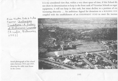 Melbourne Tram Museum
Document - Photocopies, Weston Bate and others, "Challenging Traditions - A History of Melbourne Grammar', 2016
Set of three photocopies of photographs from "Challenging Traditions - A History of Melbourne Grammar (Arcdia, Melbourne 2002) showing the cable tram winding house on the corner of St Kilda Road and Bromby St in 1919 and after redevelopment c1930. .1 - looking north with steam coming from the winding house. .2 - looking south east with winding house and surround buildings .3 - after closure and redevelopment of the site, looking north east. .4 - photo of the intersection of Victoria Parade and Gisborne St showing the cable tram track, cable trams, MFB and Eye and Ear Hospital. Shows the track layout partly. A photograph from a book "Melbourne from the Air"trams, tramways, st kilda rd, cable trams, victoria parade, brunswick st, winding houses, fitzroy -
 Melbourne Tram Museum
Slide, Keith Caldwell, March 1968?
Agfa colour blue white plastic mount slide, photo by Keith Caldwell of W2 605 or 625, southbound in Glenferrie Road, at the Kooyong level crossing. Glenferrie Road is being reconstructed with the north bound track in a temporary location. Tram has advert for Kenric clothes and Exide? batteries. The night watchman is watching the tram. His cabin is behind him.. The tram is showing (incorrectly) Kew Cotham Road destination. This is a Camberwell Depot tram bound for Malvern Town Hall assisting movement of School children in Glenferrie Road in the afternoon. Note the Camberwell Run number in the driver cab window. On the north bound track is possibly a SW6. Slide undated - c1968?trams, tramways, glenferrie rd, kooyong, level crossings, temporary track, w2 class, trackwork, kew- cotham road, tram 605, tram 625 -
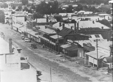 The Beechworth Burke Museum
Photograph, 1928
Taken in Beechworth at an unknown date, this photograph depicts the east side of ford street looking north from the Church of England Tower.Black and white rectangular photograph printed on matte photographic paper. Obverse: NO INSCRIPTION Reverse: 1997.2853 A03104 ph 4 3 1928 beechworth, ford street, church of england, christ church -
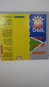 Kiewa Valley Historical Society
Brochure - Falls Creek Tourism, Falls Creek Never Out of Season
Falls Creek is a Ski Resort in the north east of Victoria. This brochure has been produced to encourage tourists to visit throughout the year.Tourism to the Kiewa Valley is an important industry for the area. Falls Creek is a ski resort with accommodation during winter for skiers, snow boarders and other snow sports. It involves entertainment, restaurants and associated workers. This brochure is produced to promote the resort throughout the year to increase the occupancy of these lodges. The tourist industry has increased steadily with fishing, cycling and bush walking increasing numbers in the area.Glossy square brochure folded in in half and half again. Front page is yellow on the left with black print on the far left. The right side has the title with blue, green and grey background with yellow, orange and white as part of the title. The back is a man standing in front of a sunset with print in a column towards the right side. Inside includes a map with advertisements for accommodation surrounding it.falls creek ski resort; alpine region in victoria; mountain lodges; -
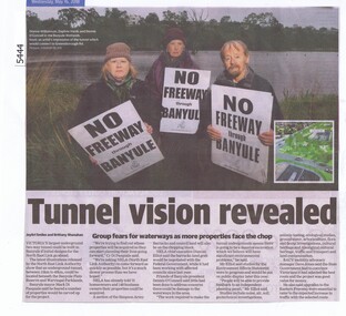 Greensborough Historical Society
Newspaper Clipping, Diamond Valley Leader, Tunnel vision revealed, 16/05/2018
Victoria's largest underground two-way tunnel could be built in Banyule if initial designs for the North East Link go ahead.News article 1 page, black text and colour image .banyule, north east link, banyule wetlands -
 Greensborough Historical Society
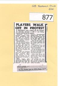
Newspaper Clipping, Diamond Valley Community Hospital, Players walk off in protest, 10/07/1972
During the final quarter of a match against Greensborough, North Heidelberg players walked off the ground in protest about the standard of umpiring.Copy of news article, text.north heidelberg football club, greensborough football club, diamond valley football league, dvfl -
 Greensborough Historical Society
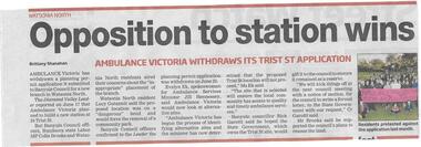
Newspaper clipping, Opposition to station wins, 01/07/2015
Ambulance Victoria has withdrawn its application to build a new branch in Trist Street Watsonia North following community concerns.News clipping, black text, colour image.trist street watsonia north, ambulance victoria -
 Greensborough Historical Society
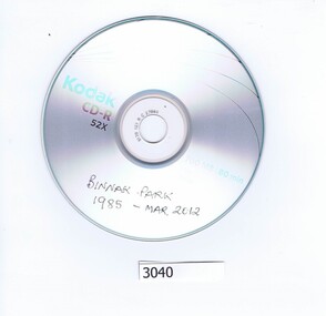
CD-ROM, Lynne Moore, Binnak Park, 1985-2012
Series of 69 colour photographs of Binnak Park area, Watsonia North, taken from 1985 to March 2012 by Lynne MooreOne CD-ROM in plastic envelopeBinnak Park 1985- Mar. 2012binnak park, watsonia north -
 Eltham District Historical Society Inc
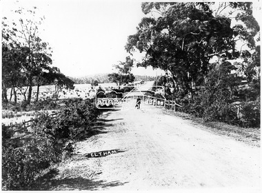
Negative - Photograph, Main Road, Eltham, c.1905
Eltham, Main Road. Looking north from Cecil Street. There is no railway line evident so prior to the extension to Hurstbridge (1912)This photo forms part of a collection of photographs gathered by the Shire of Eltham for their centenary project book,"Pioneers and Painters: 100 years of the Shire of Eltham" by Alan Marshall (1971). The collection of over 500 images is held in partnership between Eltham District Historical Society and Yarra Plenty Regional Library (Eltham Library) and is now formally known as the 'The Shire of Eltham Pioneers Photograph Collection.' It is significant in being the first community sourced collection representing the places and people of the Shire's first one hundred years.Digital image 4 x 5 inch B&W Negsepp, shire of eltham pioneers photograph collection, eltham, main road -
 Eltham District Historical Society Inc
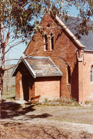
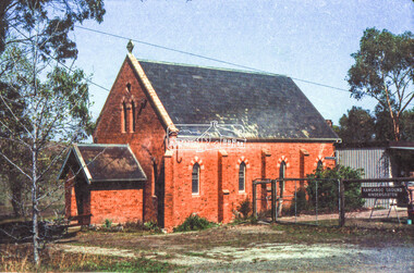
Negative - Photograph, Russell Yeoman, Kangaroo Ground Presbyterian Church, c.1980
View from front north side looking south west from cnr of Graham Road and Eltham-Yarra Glen RoadRoll of 35mm colour negative film, 2 strips Kodak Safety 5035 Colour print (x1)Kodak Safety 5035kangaroo ground, church, presbyterian church -
 Eltham District Historical Society Inc
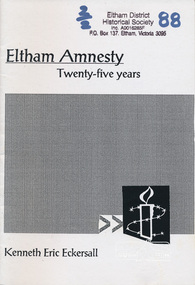
Book, Eltham amnesty : twenty-five years / Kenneth Eric Eckersall, 2002
The Eltham Branch (North East Metro Group) of Amnesty International was formed in 1977. This booklet documents its first 25 years.Paperback; iv, 27 p. ; 21 cm.amnesty international (eltham group), political prisoners -
 Eltham District Historical Society Inc
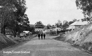
Negative - Photograph, Nearing Eltham Station, c.1904
Eltham, Main Road, looking north from Bridge Street. Gahan house on left. Bakery on right at corner of York Street.This photo forms part of a collection of photographs gathered by the Shire of Eltham for their centenary project book,"Pioneers and Painters: 100 years of the Shire of Eltham" by Alan Marshall (1971). The collection of over 500 images is held in partnership between Eltham District Historical Society and Yarra Plenty Regional Library (Eltham Library) and is now formally known as the 'The Shire of Eltham Pioneers Photograph Collection.' It is significant in being the first community sourced collection representing the places and people of the Shire's first one hundred years.Digital image 4 x 5 inch B&W Negsepp, shire of eltham pioneers photograph collection, eltham, main road, gahan house, gahan, york street -
 Ringwood and District Historical Society
Newsletter, Early Planning for Retirement Group Inc, Enjoying Planned Retirement Newsletters 1993, Feb-93
Newsletter of the Early Planning for Retirement Group Inc., later called E.P.R. Inc. meeting in the North Ringwood Senior Citizens rooms.5 pages A4 white paper with black printing and several small line drawings throughout. +Additional Keywords: Allwell, John (President) / Drew, Norma (Secretary) -
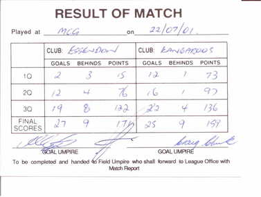 Essendon Football Club
AFL scorecard, 22/07/2001
This is the scorecard for the home-and-away game between Essendon and North Melbourne Kangaroos at the MCG which Essendon won 27.9.171 to Kangaroos 25.9.159This item is of great significance for it is the official record of the greatest comeback in VFL/AFL history. Essendon came from 69 points down in the second quarter to defeat the Kangaroos by 12 points. It has been hailed as one of the greatest games ever.White cardboard card ruled into sectionsScores for each team for each quarter have been entered in blue ink and card has been signed by three umpiresessendon football club, north melbourne kangaroos, comebacks, significant events -
Tatura Irrigation & Wartime Camps Museum
DVD, Oskar Speck
The story of Oskar Speck who was canoeing around the islands in the north of Australia when war broke out. He was interned in Australia.Double DVD case, clear case, black holder, containing 2 white DVD's. Black text. Commentary in German. 8 minutes.oskar speck, canoeing around australia, interned in australia -
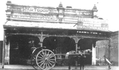 Tatura Irrigation & Wartime Camps Museum
Photograph, Tudor's jewellers shop
Tudor's jewellers shop, & Kilpatrick's Stock & Station Agency, c.1900, Hogan Street, north side, now Solicitor's offices. -
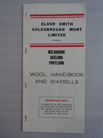 National Wool Museum
Handbook, 1966
Donated by Mrs Robyn Adams, daughter of Victor Clyde- a wool grower from North-Eastern Victoria who used this itemWhite paper booklet with four staples on left spine. Front cover has heading -ELDER SMITH / GOLDSBROUGH MORT / LIMITED-. at top centre. Text also reads -WOOL HAND-BOOK / AND WAYBILLS-. Text is black and there are four red horizontal bars on the cover. Inside front cover has list of points to remember. First pages have instructions. Booklet contains several lined yellow pages which can be copied with carbon paper, or removed. Inside back cover has a foldable map. Back cover had a ready reckoner printed.wool sales, wool auction, wool transport, mrs robyn adams, elder smith goldsbrough mort limited, dalgety and company limited elder smith goldsbrough mort limited -
 National Wool Museum
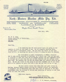
Letter
Letter, on "North Western Woollen Mills Pty Ltd" letterhead, 16th July 1957, regarding water proofing test resultswool - research wool - testing textile testing, gordon institute of technology north western woollen mills pty ltd, lang, dr w. roy, wool - research, wool - testing, textile testing -
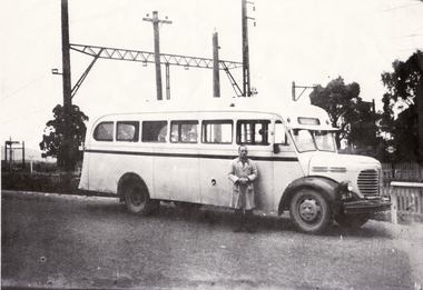 Whitehorse Historical Society Inc.
Photograph, Bill Glasson & Bus
Bill Glasson and Charlie Young owner the bus. The terminal was on the north side of Mitcham Railway Station. Route was Mitcham to Park Orchards.Black and white photo of Bill Glasson and Local Bus. Documents accompanying: ND1837 glasson, bill, bus