Showing 17212 items matching "bay-bridge"
-
 Melbourne Tram Museum
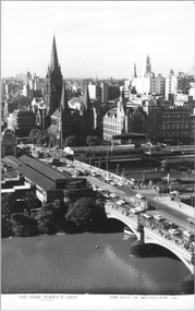
Postcard, Rose Stereograph Co, "The City of Melbourne", early 1950s
Rose Series postcard No. P 14227 titled "The City of Melbourne", with Flinders St and Princes Bridge station buildings, St Paul's Cathedral, Gas and Fuel and Ball and Welch buildings in the view. There are some 10 trams in the view. There is a Craven A cigarette advert on the south end of the station buildings. See also item 8058 for a similar photo.Yields information about Flinders Street Railways Station and the Melbourne skyline, late 1950s.Postcard - printed real photograph with Rose Stereograph Co. name on the rear.trams, st kilda road, swanston st, flinders st station, princes bridge station, tramways, princes bridge, w2 class -
 Melbourne Tram Museum
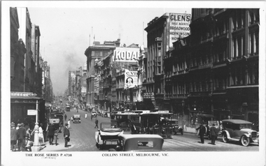
Postcard, Rose Stereograph Co, "Collins Street Melbourne", c1928
Rose Series postcard No. P 4738, titled "Collins Street Melbourne", looking west from Swanston Street. Has several cable trams in the view, the nearest one having a destination of "Victoria Bridge". There are adverts for Kodak, and "Listen in Radios". A "Tramway Inspector?" is standing in the safety zone. The Collins Street cable trams were closed in 1929.Yields information about Collins St c1928Postcard - printed real photograph with Rose Stereograph Co. name on the rear.Has the Ken Magor stamp on the rear.trams, tramways, cable trams, collins st -
 Melbourne Tram Museum
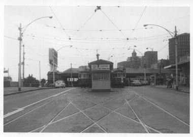
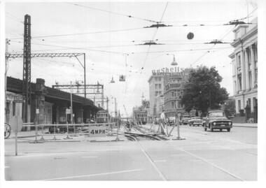
Photograph - Batman Ave tram terminus, David Menzies, 21-11-1971
The photograph shows the scissors cross over and signage at the Batman Ave tram terminus - Princes Bridge. Has two W2 class trams at the terminus, with Flinders St station in the background. This terminus was relocated as part of the Federation Square and Tennis Centre developments during 1999 - see reference. Photo by David Menzies, 21/11/1971.Provides information about the Batman Ave tram terminus.Black and white photograph with notes on rear.trams, tramways, mmtb, batman ave, w2 class, flinders st station -
 Sunbury Family History and Heritage Society Inc.
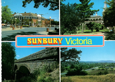
Postcard, Newcolourvue Productions Pty.Ltd, Sunbury Victoria, c1970s
The four photographs on the post card are well-known places in the town. They are the 1930s Royal Hotel building which was build on the same site of the original building on the corner of Evans and Brook Streets, Rupertswood Mansion, built 1874-45, the historic bluestone road bridge over Jacksons Creek and a view of the township in the 1970s taken from Francis Boulevard.The four views of Sunbury give an overview of the township in the 1970s before the increased development took place from the 1980s onwards.A coloured collection of four non-digital photographs of places in Sunbury in post card format. The edges of the post card are rippled. the back of the card gives details of the places as well as the maker.Sunbury Victoriaroyal hotel, rupertswood mansion, bluestone road bridge, sunbury, post cards -
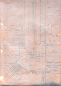 Melbourne Tram Museum
Drawing - Swanston St underground tramway at Flinders St, Melbourne & Metropolitan Tramways Board (MMTB), mid 1960s
Drawing shows the proposed layout of the Swanston St underground tram line at Flinders St. Shows the tram stop, the layout of the access to the stop, Flinders St and Princes Bridge stations, the demolition of Young and Jacksons Hotel, a railway booking office. This was part of a project that was for undergrounding of a number of tram lines in Melbourne during the early to mid 1960s. Yields information about the proposed undergrounding of the Swanston St tram line at Flinders St.Foolscap photocopied sheet on heat sensitive paper with four punched holes on the side.tramways, underground tramways, swanston st, proposed works, flinders st station -
 Eltham District Historical Society Inc
Document - Folder, Shanhun, Cheon and James
Cheon Shanhun lived between Wattle Glen and Hurstbridge from about 1870 to 1900. His son James settled in Panton Hill. Contents Letter Alison Connett, 27 December 1993, seeking information on the naming of Shanhuns Road, Cottles Bridge. Photocopy of photograph, group of people c1929, Mrs Jim Shanhun identified.Newspaper clippings, A4 photocopies, etccheong shanhun, james shanhun, shanhuns road cottles bridge, panton hill -
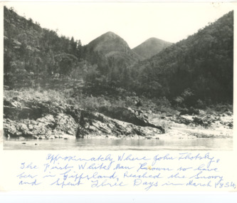 Lakes Entrance Historical Society
Photograph - Snowy River Buchan, 1977 c
Polish scientist explorer Dr. Lhotsky explored the Australian Alps south of Mt Kosciusko (not named at that date)as far as McKillops Bridge (unnamed then) between 1834 and 1839. His claims were largely ignored he being labelled imposter and humbug but recent research indicates his rightful place amongst Victorias early explorersBlack and white photograph of Snowy River at Suggan Buggan VictoriaApproximately where John Lhotsky the first white man known to have been in Gippsland reached the Snowy and spent three days in March 1834topography, rivers -
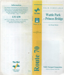 Melbourne Tram Museum
Ephemera - Timetable - route 70 - Wattle Park - Princes Bridge, The Met, 2/1998
Timetable - route 70 - Wattle Park - Princes Bridge, dated 22/2/1998, published by The Met, with Yarra Trams logo as well, and PTC name on the rear cover. Has a map of the route, forward by Geoff Lockwood Operations Supt of Camberwell depot, the Met Fare system, an advert for tram hire, timing points, and contact information.Demonstrates a timetable at the time of the formation of Yarra Trams when it was operated by The Met and the PTC.Timetable - printed, centre stapled, 24 pages.tramways, timetables, route 70, wattle park, the met, yarra trams -
 Ballarat Tramway Museum
Slide - 27 mm sq slide/s - set of 8 - tram tracks - Victoria St, Lilian Butler, Aug. 1971
Yields information about the streetscapes of Ballarat on the Gardens to Victoria St route and in particular buildings and people that crewed the trams.Set of eight Colour 27 x 27 mm slide in a Kodachrome cardboard mount. .1 - view of the Sturt and Lydiard St intersection from the front of the tram car with the Robbie Burns statue in the view and the Big W store. .2 - ditto at the corner of Sturt and Grenville St with the tramway shelter and the Dickins store. .3 - setting the signals for the Bridge St route. .4 - View looking east along Bridge St with Big W store and Faull's shoe shop. .5 - At intersection with Main Road, looking up the hill towards Victoria St. On the right is the advert for Viscount Ambassador Caravans. .6 - Looking along Victoria St, towards the East at E St, with the biscuit factory on the left. .7 - tram shelter at Queen St. .8 - View of the terminus looking east, showing the median strip Slide mount date August 1971. Photo from the collection of Lilian Butler.ballarat, tramways, trams, sturt st, grenville st, shelters, bridge st, signals, victoria st -
 Kew Historical Society Inc
Plan - Subdivision Plan, Oswinia Estate, East Kew, c.1925
Prue Sanderson, in her groundbreaking ‘City of Kew Urban Conservation Study : Volume 2 - Development History’ (1988), summarised the periods of urban development and subdivisions of land in Kew. The periods that she identified included 1845-1880, 1880-1893, 1893-1921, 1921-1933, 1933-1943, and Post-War Development. These periods were selected as they represented periods of rapid growth or decline in urban development. An obvious starting point for Sanderson’s groupings involved population growth and the associated economic cycles. These cycles also highlighted urban expansion onto land that was predominantly rural, although in other cases it represented the decline and breakup of large estates. A number of the plans in the Kew Historical Society’s collection can also be found in other collections, such as those of the State Library of Victoria and the Boroondara Library Service. A number are however unique to the collection.Subdivision plans are historically important documents used as evidence of the growth of suburbs in Australia. They frequently provide information about when the land was sold on which a built structure was subsequently constructed as well as evidence relating to surveyors and real estate and financial agents. The numerous subdivision plans in the Kew Historical Society's collection represent working documents, ranging from the initial sketches made in planning a subdivision to printed plans on which auctioneers or agents listed the prices for which individual lots were sold. In a number of cases, the reverse of a subdivision plan in the collection includes a photograph of a house that was also for sale by the agent. These photographs provide significant heritage information relating house design and decoration, fencing and household gardens.The ‘Oswinia Estate’ subdivision in East Kew was planned and auctioned in the first half of the 1920s. 169 allotments were created in the triangular section of land bordered by High Street, Burke Road and the Government Boulevard (later Kilby Road). The only piece of land excluded was that where the previous Kew Pound had been located at the east tip of the triangle. Allotments were created fronting Glass, High, Namur, Oswin Streets, Irymple Avenue, and the Government Boulevard. The name for the Estate was derived from Oswin’s farm, which had been one of the largest landholdings in East Kew. The selling agents annotated the plan in our collection with crosses indicating those lots that had been sold. The inset locality plan is particularly interesting as it shows the route and stations of the Outer Circle Railway. When the subdivision plan was created, it included the proposed bridge over the Yarra at Burke Road. The bridge was to be officially opened in 1926.subdivision plans - east kew, oswinia estate, high street, glass street, namur street, government boulevard - kilby road, irymple street, oswin street -
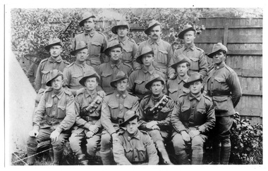 Tarnagulla History Archive
Photograph of soldiers from Tarnagulla and district, Soldiers from Tarnagulla and district, Exact date unknown, circa 1914-1918
Murray Comrie Collection.Monochrome photograph of soldiers in uniform. Subjects are residents of Tarnagulla and other towns in surrounding district. All subjects served in First World War, dating the image to circa 1914-1918. Accompanied by a note that gives the following names: (Left to Right) Back Row: 1. Jim Browbill (Simpson's Creek) 2. Geo. Whyte (Tarnagulla) 3. Ken Bramley (Arnold's Bridge) 4. Geo. Riordan (Arnold's Bridge) Third Row from front: 1. Harold Spedding 2. Hewie Spedding (Laanecoorie) 3. Jack Graham (Murphy's Creek) 4. Syd Akers (Tarnagulla) 5. Geo. Corrie (Tarnagulla) Second row from front: 1. Geo. Clark (Llanelly) 2. Allan Mitchell (Llanelly) 3. Sergt. Anderson (Laanecoorie) 4. Jack Mitchell (Llanelly) 5. Will Kilgour (Tarnagulla) Front Row: 1. Fred Jackson (Tarnagulla) Same image as THA-2019.0203, which is an original print.tarnagulla, llanelly, laanecoorie, arnold, arnold's bridge, simpson's creek, murphy's creek, war, military, service, soldiers, veterans, ww1, first world war, kilgour, jackson, clark, mitchell, anderson, spedding, graham, akers, corrie, brownbill, whyte, bramley, riordan -
 Bendigo Historical Society Inc.
Postcard - Australia, Elliot Collection, 1895 - 1914
Thought to have originated in Austria in 1869, postcards first gained popularity in Australia in the 1890s.They were used to send short messages to friends and family. This collection was generated by Mary Emma Elliot of Talgarno. Talgarno is a rural locality in Victoria, Australia, situated on the southern shoreline of Lake Hume, about 23 km east of Albury-Wodonga. The collection contains postcards from across the world. Mary Emma Sibley was born in Ironbark, Bendigo in 1859. She married James Elliot in 1893 and they settled at “Kelso”, Talgarno. They had two children – Mona and Sibley. Mary Emma Elliot died in Melbourne in 1944, aged 84 years. Australian postcards collected by Mrs. James Elliot between 1898 and 1915. 1405.261 Port Arthur, Dead Island No 1 1405.262 Launceston, Crusoe Hut, Cataract Gorge 1405.263 Kathleen Sound, Gordon River, W. Coast. Tasmania 1405.264 St. Patrick's Head. East Coast. Tasmania 1405.265 Hobart 1405.266 Restless Seas, Coast of Australia 1405.267 Brown's River Road 1405.268 The Rocking Stone, Mt. Wellington 1405.269 Cataract Gorge, Launceston. Tas 1405.270 Mount Olympus. Tasmania 1405.271 Latrobe Road near Devonport 1405.272 Salmon Ponds, New Norfolk 1405.273 Launceston from Trevallyn 1405.274 Burnie, N. W. Coast. Tasmania 1405.275 River Derwent, near New Norfolk 1405.276 Botanic Gardens, Hobart, Tasmania 1405.277 "The Winter Garden" 1405.278 Hobart Waterworks 1405.279 LAUNCESTON. King's Bridge 1405.280 The Bridge. Perth (Tasmania)postcards, collecting, collections, talgarno -
 Federation University Art Collection
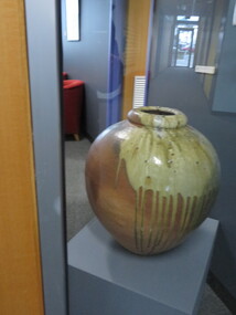
Ceramic - Artwork - Ceramic, 'Wood Fired Urn' by Robert Barron
Robert BARRON (1957- ) Born in Harpenden, England. Robert Barron first worked full-time with clay in 1976, the family pottery at Croydon, Victoria. In 1979, he left Australia on a five-year journey to New Zealand, North America, England, Europe, and South Korea to work with skilled potters in woodfiring. During this time, he visited Michael Cardew at Wenford Bridge Pottery, Cornwall, UK., and was engaged as an apprentice at Cornwall Bridge Pottery, Connecticut, USA. Returning to Australia in 1984, he established Gooseneck Pottery at Kardella, Victoria. With the assistance of a Crafts Board grant Robert Barron built a 1000 cubic ft five-chambered Nabori-Gama style woodfired kiln. This kiln one of the largest wood-fired kilns in Australia. Robert Barron is influenced by the philosophies of Bernard Leach and Michael Cardew.artwork, artist, ceramic, gippsland campus, robert barron -
 Linton and District Historical Society Inc
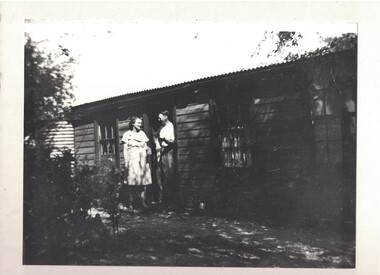
Photograph, Joe Reidy and Stella Pearse, undated
The house is identified in the early LDHS index to photographs as being "Joe and Stella Reidy's home on Geelong Road" (Geelong Road now called Linton-Naringhil Road). Joe Reidy and Stella Pearse married in 1938. Information provided in 2025: "Joe and Stella out the back of their house. It has a flat roof on the back verandah and a normal peaked roof on the house. The house is on Naringhil Rd opposite side of road to Linton Park and back towards Linton. It used to have a foot bridge over the small creek, but now it has a pipe and driveway. At the back of the house is an old dairy where Joe would milk the cows morning and night after working the day for the Shire. The small foot bridge had decorative pine cones along it. Lovely garden etc. Joe was also Captain of the fire brigade for a long time." Enlarged black and white copy of original photograph, which has been mounted on white card. The photograph shows a young woman and young man standing outside a timber cottage. On card attached to bottom of photograph: "Joe Reidy and Stella Pearse (Mick Chung was born in this house.)"joe reidy, stella reidy nee pearse -
Glen Eira Historical Society
Book - Local Government Act First Report of the Assistant Commissioner of Roads and Bridges
This file contains 1 item: 1/The Local Government Act, First Report of the Assistant Commissioner of Roads and Bridges, printed by order of the Victorian Legislative Assembly on 08/03/1865. The document is the first annual report of John Steavenson, Assistant Commissioner of Roads and Bridges under s330 of the Local Government Act no. 176 (1863), and relates to transactions which took place from 02/09/1863 to 31/12/1864. The report outlines operations carried out by the Department of Roads and Bridges in this period. In the Glen Eira area this includes: separating electoral subdivisions of single districts (Moorabbin), adding detached portions of territory to road districts and shires (Caulfield), appointing of and altering in polling places, appointing of polling places for ridings of shires and subdivisions of road districts (Moorabbin), preparing and transmitting of forms of books also of pro forma accounts for guidance of local bodies in keeping their accounts, appointment of main roads, construction of a main road, ‘Dandenong’, in the Caulfield and Gardiner districts, proclaiming of Common Toll Roads, names of and security given by Managers of Common Toll Roads. The report also gives some information about the Shire of Caulfield, which contained 24 road districts and 340 rate payers in 8¼ square miles, and the Shire of Moorabbin, which contained 62 road districts and 713 rate payers in 30 square miles.local government act, assistant commissioner of roads and bridges, legislative council, caulfield historical soceity, steavenson john, sullivan j. f. the honourable, caulfield, moorabbin, road districts, point nepean road, nepean highway, dandenong road, princes highway, brown edwin, osher joseph, cosgrove john, ferres john, roads and bridges offices, caulfield roads district, moorabbin roads district, road construction and maintenance, roads and streets, acts of parliament -
 Melbourne Tram Museum
Photograph - Set of 12 - construction of King St overpass in Flinders St, 1959
Photos show the construction of King St overpass in Flinders St which was part of the project to construct a bridge over the Yarra River and provide a new southern outlet road between the city and eventually St Kilda Junction. The overpass construction was commenced in 1959 with tramway works first commencing. It was demolished in 2005. 1 - looking west at Market St. 2 - looking east from Spencer and Flinders St with the railway viaduct behind. 3 - Tram lines diverted onto the new overpass. Note the hand-powered overhead tower on the left behind the compressor. 4 - Tracks partially diverted. 5 - Looking east at Spencer and Flinders St with a Dunlop tyre truck in the view. 6 - prior to the diversion onto the new bridge. 7 - Looking east near William St. with W2 451 (Route 48, North Balwyn) in the view. 8 - Bridge works near King St. Original tracks still in use. 9 - Looking east prior to the introduction of the temporary tracks on the south side of the new overpass. 10 - SW6 852 and a W2 on new overpass trackwork - old trackwork being demolished. 11 - Cross over at Spencer St in Flinders St, prior to change over. 12 - Looking west at Flinders and Spencer St with SW6 853 turning into Spencer St.Yields information about the construction of the King St overpass in Flinders St during 1959.Set of 12 black and white prints of the construction of the King St overpass in Flinders St.trams, tramways, flinders st, king st overpass, construction, bridges, w2 class, sw6 class, tram 451, tram 853, tram 852 -
Kew Historical Society Inc
Archive (Sub-series) - Subject File, Kew Historical Society, Gardens (Kew), 1979
Various partiesReference, Research, InformationSecondary Values (KHS Imposed Order)Correspondence and newspaper articles/clippings relating to historic gardens in Kew. The oldest item is a letter from the National Trust Victoria announcing their two-year garden study and seeking information on gardens in Kew. Mavis Rolley, Secretary of the Society, made handwritten notes in response, which are kept in the file. She refers to: the pear trees planted by William Oswin in c. 1845 near what is now the Burke Road Bridge (she notes that a search for the trees at the time of the construction of the Eastern Freeway was unsuccessful), a camellia planted by the Dannocks near the corner of Derby and High Street, a c.1876 pine tree in Field Place, Henty Court, an 1875 Moreton Bay fig at Tarring, Ruyton, a Moreton Bay fig at Roxeth, Trinity Grammar, an 1840s oak tree and a 120-year old olive tree at Fairholme, Barry Street, 1870 pine trees at D’Estaville, Barry Street, trees at Turinville, Barnard Grove, dating to 1846, pine trees dating from 1845-6 on the Willsmere Farm, red gums in Victoria Park, pine trees in the Cemetery dating from the 1860s, trees in the Alexandra Gardens and at Kew Primary School, palm trees at La Verna, Sackville Street dating from the 1890s, the trees and gardens at Ross House (Charleville), and the trees at Merridale, Sackville Street which date from the 1880s, a magnolia at Lalla Rookh. These dates are probably highly contestable. Other handwritten notes from 1979 about significant gardens included: 5 Molesworth Street, Red Bluff - Redmond Street (garden now destroyed), Campion House, Studley Park Road, Raheen, Studley Park Road, Ross House, Cotham Road (Charleville), 7 Adeney Avenue, 20-21 Belmont Avenue, 52 Mary Street, an Edna Walling garden on the corner of Argyle Road and Victor Avenue, Merridale, Sackville Street, Roseneath, and Reno, St John’s Parade.gardens - private - kew (vic), garden design - kew (vic), kew horticultural societygardens - private - kew (vic), garden design - kew (vic), kew horticultural society -
 Melbourne Legacy
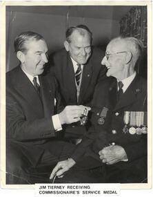
Photograph - Photo, Legatees, Jim Tierney, c.1960
Two legatees with James Tierney and his Corps of Commissionaires service medal. The notes on the back infer that Legatees were involved in the commemoration of James Tierney's life by arranging his burial at sea. An article in The Age 6 Jan 1953 mentions that Jim Tierney was the first paid instructor employed by Legacy for physical training classes in 1927. He also became one of the two Commissionaires at the Shrine of Remembrance for 12 years up to 1953. The service medal he is receiving in the photo comes from the Corps of Commissionaires Association (Australia), which has information at http://www.thecorps.com.au. A summary: "The Corps of Commissionaires was founded in London 1859 by Sir Edward Walter KCB. The original aim was to provide to employment and welfare support for veterans of the Crimean War. The Corps of Commissionaires was established in Australia in New South Wales in 1939 and became based in Victoria in 1946. There are Corps members in all states in Australia from all three Australian military services. Our members range from World War 2 veterans through all conflicts to Timor and Peacekeepers. The Corps is currently an ex-service, welfare and philanthropic organisation that is located at the Veterans Centre in the Heidelberg Repatriation Hospital, Victoria." The details of the three legatees mentioned are: Legatee Samuel J. Benson (Lieut.Commander) – born 12.7.1909, inducted 17 October, 1950, died 26.7.95. Served in WWII with the RAN for 6 years. He was a Junior Legatee before the war, and Legacy found him a job in the office of an Adelaide Shipping Company. After the war he became a Master Mariner, Sea Pilot. He was proposed as a Legatee by Stan Savige. Legatee Donald J. Simonson (Captain) – born 21.5.1920, inducted 27 July 1953, died 11.7.2010. Served in WWII in 39th Battn., Decorated with M.C. Worked as an Importer and Manufacturers Agent after the war. President of Melbourne Legacy 1970. Legatee Adrian Beattie (Captain) – born 21.3.1920, inducted 10.10.1950, died 8.8.1989. Served as a Signal Officer in 24th Btn. After the war worked as a Physiotherapist.A record of a type of work done by Legatees.Black and white photo of two Legatees and Jim Tierney.Front of photo has a typed label saying: "Jim Tierney receiving Commissionaire's Service Medal". The back "James Edward TIERNEY at Royal Park receiving Service Medal, Corps of Commissionaire. Buried at Sea (1963): by Legatees Sam Benson, Donald Simonson, Adrian Beattie, and families in Port Philip Bay by kind favour Port Philip Pilot Service" in blue ink.legatee event, jim tierney, boys classes -
 Flagstaff Hill Maritime Museum and Village
Photograph
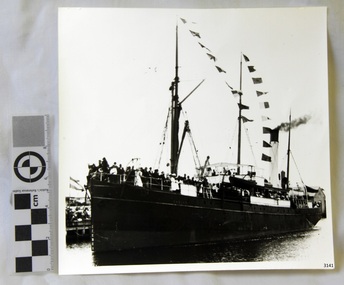
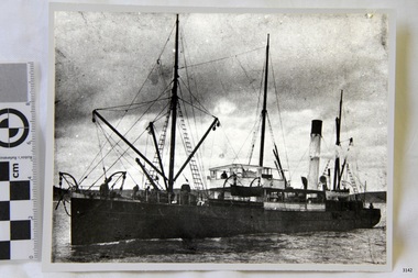
Black and White Photograph of S.S Casino arriving in Port. Taken 1930-1932. People on the deck and on the river banks waving. Smoke coming from funnel. The S.S. Casino was a passenger and freight steamer built in Dundee, Scotland, in 1882 for the Newcastle and Hunter River Steam Navigation Company of N.S.W. She weighed 425 tons gross with a length of 160.4 feet, beam of 24.1 feet and depth of 10.2 feet. She had saloon accommodation for 35 people, forecabin for 25 more people, and she carried 300 tons of cargo. While on her delivery journey on May 30th 1882 the S.S. Casino called in at the Port of Warrnambool for coal ., narrowly escaping going ashore in gale force winds due to the quick action of the pilot. At that time, still at anchor, she impressed the directors of the Belfast and Koroit Steam Navigation Company so much that they bought her immediately; she was ideal for trade in along the West Coast of Victoria. (Belfast is the original name for Port Fairy, South West Victoria. The Belfast and Koroit Steam Navigation Company was first managed by Messers. Saltau and Osburne and after the passing of Mr. Osburne, by produce merchants Messers H. Sautau and Sons, whose had a hay and corn store and shipping agency was on the corner of Liebig and Koroit Streets in Warrnambool. ) The S.S. Casino became “the most famous steamer to operate in Victorian waters along the West Coast” by author Jack Loney. Captain Boyd was her first Master, followed by Captain Chapman, who stayed with her 1890 until 1924. Captain W. Robertson followed for a short term, then Captain Middleton then took command 1925 - 1932. The S.S. Casino had several mishaps during her life. One was on 3rd January 1898 when she collided with the S.S. Flinders in Apollo Bay with minor damage. Another was on 24th October 1924 when she grounded on a reef at Point Hawdon near Grey River and most of her cargo (of Christmas goods) had to be dumped into the sea. Then in February 1929 she was ‘holed’ when she struck a submerged object as she entered Lady Bay, Warrnambool. On the morning of 10th July 1932, after attempting to berth at Apollo Bay jetty in heavy seas, Captain Middleton decided to take her out into the bay and wait until the seas abated. It was not realised that the anchor used to steady her as she manoeuvred to her berth had pierced her hull. She put about and headed for the beach but sank. Captain Middleton and nine others lost their lives; nine people were rescued including the two female passengers . Captain Middleton had been in charge of the S.S. Casino for seven years. He was the first ship’s Master to lose his life through shipwreck in the West Coast trade. In the years following the turn of the century the S.S. Casino remained the only regular trader with normal passenger accommodation along the West Coast. From 1882 she had made at least 2,500 voyages on the one run. Flagstaff Hill’s collection has a photograph of a portrait of Captain Chapman, , a ship model of the S.S. Casino that shows both forms of power under which she sailed, steam and sail. The ship is painted green and flies three flags. The inscription across the case of the ship model, incorrectly dated, tells the sad story of the wreck of the ship and the loss of lives on July 10th 1932 at Apollo Bay. A print in the Collection show S.S. Casino underway in heavy sea off Point Lonsdale, another two photographs show her at the Port of Warrnambool, leaving from the Breakwater in Lady Bay and another identifies the S.S. Casino as a ship from the Belfast and Koroit Steam Navigation Company. (Belfast is the original name for the township of Port Fairy). This photograph is significant because of its association with the coastal trader S.S. Casino 1930 -1932 and its significance to trade along Victoria's West Coast in the late 19th and early 20th century. The wreck of the S.S. Casino is considered an important part of Victorian and Australian cultural heritage and as such has been declared and protected as an Historic Shipwreck Black and White Photograph of S.S Casino arriving in Port. Taken 1930-1932. People on the deck and on the river banks waving. Smoke coming from funnel.flagstaff hill, warrnambool, shipwrecked coast, flagstaff hill maritime museum, maritime museum, shipwreck coast, flagstaff hill maritime village, great ocean road, newcastle and hunter river steam navigation company, belfast and koroit steam navigation company, h. sautau and sons, s.s. casino, west coast trader s.s. casino, victorian coastal trader, captain boyd, captain w. robertson, captain chapman, captain middleton, apollo bay shipwreck, s.s. casino at lady bay warrnambool, saltau and osburne -
 Flagstaff Hill Maritime Museum and Village
Photograph
Black and White Photograph of S.S Casino taken 1930-1932. Ship has men on deck and a man at the helm. Hills and the shore can be seen in the background. The S.S. Casino was a passenger and freight steamer built in Dundee, Scotland, in 1882 for the Newcastle and Hunter River Steam Navigation Company of N.S.W. She weighed 425 tons gross with a length of 160.4 feet, beam of 24.1 feet and depth of 10.2 feet. She had saloon accommodation for 35 people, forecabin for 25 more people, and she carried 300 tons of cargo. While on her delivery journey on May 30th 1882 the S.S. Casino called in at the Port of Warrnambool for coal ., narrowly escaping going ashore in gale force winds due to the quick action of the pilot. At that time, still at anchor, she impressed the directors of the Belfast and Koroit Steam Navigation Company so much that they bought her immediately; she was ideal for trade in along the West Coast of Victoria. (Belfast is the original name for Port Fairy, South West Victoria. The Belfast and Koroit Steam Navigation Company was first managed by Messers. Saltau and Osburne and after the passing of Mr. Osburne, by produce merchants Messers H. Sautau and Sons, whose had a hay and corn store and shipping agency was on the corner of Liebig and Koroit Streets in Warrnambool. ) The S.S. Casino became “the most famous steamer to operate in Victorian waters along the West Coast” by author Jack Loney. Captain Boyd was her first Master, followed by Captain Chapman, who stayed with her 1890 until 1924. Captain W. Robertson followed for a short term, then Captain Middleton then took command 1925 - 1932. The S.S. Casino had several mishaps during her life. One was on 3rd January 1898 when she collided with the S.S. Flinders in Apollo Bay with minor damage. Another was on 24th October 1924 when she grounded on a reef at Point Hawdon near Grey River and most of her cargo (of Christmas goods) had to be dumped into the sea. Then in February 1929 she was ‘holed’ when she struck a submerged object as she entered Lady Bay, Warrnambool. On the morning of 10th July 1932, after attempting to berth at Apollo Bay jetty in heavy seas, Captain Middleton decided to take her out into the bay and wait until the seas abated. It was not realised that the anchor used to steady her as she manoeuvred to her berth had pierced her hull. She put about and headed for the beach but sank. Captain Middleton and nine others lost their lives; nine people were rescued including the two female passengers . Captain Middleton had been in charge of the S.S. Casino for seven years. He was the first ship’s Master to lose his life through shipwreck in the West Coast trade. In the years following the turn of the century the S.S. Casino remained the only regular trader with normal passenger accommodation along the West Coast. From 1882 she had made at least 2,500 voyages on the one run. Flagstaff Hill’s collection has a photograph of a portrait of Captain Chapman, , a ship model of the S.S. Casino that shows both forms of power under which she sailed, steam and sail. The ship is painted green and flies three flags. The inscription across the case of the ship model, incorrectly dated, tells the sad story of the wreck of the ship and the loss of lives on July 10th 1932 at Apollo Bay. A print in the Collection show S.S. Casino underway in heavy sea off Point Lonsdale, another two photographs show her at the Port of Warrnambool, leaving from the Breakwater in Lady Bay and another identifies the S.S. Casino as a ship from the Belfast and Koroit Steam Navigation Company. (Belfast is the original name for the township of Port Fairy). This ohotograph is significant because of its association with the coastal trader S.S. Casino 1882-1932 and its significance to trade along Victoria's West Coast in the late 19th and early 20th century. The wreck of the S.S. Casino is considered an important part of Victorian and Australian cultural heritage and as such has been declared and protected as an Historic Shipwreck under State and Commonwealth Law in the Commonwealth Historic Shipwrecks Act (1976). Black and White Photograph of S.S Casino taken 1932-1932. Ship has men on deck and a man at the helm. Hills and the shore can be seen in the background.flagstaff hill, warrnambool, shipwrecked coast, flagstaff hill maritime museum, maritime museum, shipwreck coast, flagstaff hill maritime village, great ocean road, newcastle and hunter river steam navigation company, belfast and koroit steam navigation company, h. sautau and sons, s.s. casino, west coast trader s.s. casino, victorian coastal trader, captain boyd, captain w. robertson, captain chapman, captain middleton, apollo bay shipwreck, s.s. casino at lady bay warrnambool, saltau and osburne -
 Flagstaff Hill Maritime Museum and Village
Photograph
The S.S. Casino was a passenger and freight steamer built in Dundee, Scotland, in 1882 for the Newcastle and Hunter River Steam Navigation Company of N.S.W. She weighed 425 tons gross with a length of 160.4 feet, beam of 24.1 feet and depth of 10.2 feet. She had saloon accommodation for 35 people, forecabin for 25 more people, and she carried 300 tons of cargo. While on her delivery journey on May 30th 1882 the S.S. Casino called in at the Port of Warrnambool for coal ., narrowly escaping going ashore in gale force winds due to the quick action of the pilot. At that time, still at anchor, she impressed the directors of the Belfast and Koroit Steam Navigation Company so much that they bought her immediately; she was ideal for trade in along the West Coast of Victoria. (The Belfast and Koroit Steam Navigation Company was first managed by Messers. Saltau and Osburne and after the passing of Mr. Osburne, by produce merchants Messers H. Sautau and Sons, whose had a hay and corn store and shipping agency was on the corner of Liebig and Koroit Streets in Warrnambool. ) The S.S. Casino became “the most famous steamer to operate in Victorian waters along the West Coast” by author Jack Loney. Captain Boyd was her first Master, followed by Captain Chapman, who stayed with her 1890 until 1924. Captain W. Robertson followed for a short term, then Captain Middleton then took command 1925 - 1932. The S.S. Casino had several mishaps during her life. One was on 3rd January 1898 when she collided with the S.S. Flinders in Apollo Bay with minor damage. Another was on 24th October 1924 when she grounded on a reef at Point Hawdon near Grey River and most of her cargo (of Christmas goods) had to be dumped into the sea. Then in February 1929 she was ‘holed’ when she struck a submerged object as she entered Lady Bay, Warrnambool. On the morning of 10th July 1932, after attempting to berth at Apollo Bay jetty in heavy seas, Captain Middleton decided to take her out into the bay and wait until the seas abated. It was not realised that the anchor used to steady her as she manoeuvred to her berth had pierced her hull. She put about and headed for the beach but sank. Captain Middleton and nine others lost their lives; nine people were rescued including the two female passengers . Captain Middleton had been in charge of the S.S. Casino for seven years. He was the first ship’s Master to lose his life through shipwreck in the West Coast trade. In the years following the turn of the century the S.S. Casino remained the only regular trader with normal passenger accommodation along the West Coast. From 1882 she had made at least 2,500 voyages on the one run. Flagstaff Hill’s collection has a photograph of a portrait of Captain Chapman, , a ship model of the S.S. Casino that shows both forms of power under which she sailed, steam and sail. The ship is painted green and flies three flags. The inscription across the case of the ship model, incorrectly dated, tells the sad story of the wreck of the ship and the loss of lives on July 10th 1932 at Apollo Bay. A print in the Collection show S.S. Casino underway in the heavy sea off Point Lonsdale, another two photographs show her at the Port of Warrnambool, leaving from the Breakwater in Lady Bay and another identifies the S.S. Casino as a ship from the Belfast and Koroit Steam Navigation Company. (Belfast is the original name for the township of Port Fairy).This photograph of Captain Capman is significant because of its association with the coastal trader S.S. Casino and its significance to trade along Victoria's West Coast in the late 19th and early 20th century. The wreck of the S.S. Casino is considered an important part of Victorian and Australian cultural heritage and as such has been declared and protected as an Historic Shipwreck under State and Commonwealth Law in the Commonwealth Historic Shipwrecks Act (1976). Photograph of Captain Chapman of the "S.S.Casino", mounted on card board. flagstaff hill, warrnambool, shipwrecked coast, flagstaff hill maritime museum, maritime museum, shipwreck coast, flagstaff hill maritime village, great ocean road, newcastle and hunter river steam navigation company, belfast and koroit steam navigation company, h. sautau and sons, s.s. casino, west coast trader s.s. casino, victorian coastal trader, captain boyd, captain w. robertson, captain chapman, captain middleton, apollo bay shipwreck, s.s. casino at lady bay warrnambool, saltau and osburne -
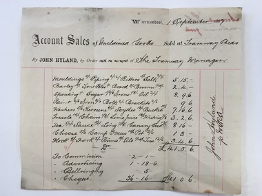 Warrnambool and District Historical Society Inc.
Docket, Hyland/ Tramways Sheds, Circa 1887
In 1858 a tramway was constructed to move goods between Warrnambool township and jetty on Lady Bay. It was established on the south side of Merri St in the approximate site of the present railway station. Large stores were also built near where the present rail lines to hold produce. This docket relates to unclaimed goods and range from tent poles, brooms, sugar scythes, lime juice tea, sauce, camp ovens and ale. John Hyland was the manager who was later mayor of Warrnambool. The Warrnambool tramway was an important part of transportation of goods in the 19th century from the port to the township which was over a mile away. White docket with some text printed in black with other sections handwritten in black pen. Dated September 1887. It shows a list of varied items. Signed John Hyland. “Account sales unclaimed goods by J Hyland Sep 1887” is in red pen on the back. warrnambool, warrnambool tramways, john hyland, unclaimed goods, -
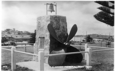 Port Fairy Historical Society Museum and Archives
Photograph, SS Casino Memorial Pt Fairy
A memorial to those who died when the S.S.Casino ran aground in bad weather at Apollo Bay in 1932. This memorial held the original propeller, the wreck bell and a barometer. The wreck bell was removed in later years because of continuous ringing by mischief makers and the barometer also was removed. The barometer was placed there for the fishermen to consult before going to sea. A service is held every year at 11 a.m. July 10th to commemorate the sinking of the ship. The names of the nine people who died is inscribed on a plaque on the side.Black and white photographmemorial, s.s.casino, propeller -
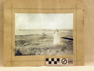 Flagstaff Hill Maritime Museum and Village
Photograph - Historical, maritime, Brookes' Photographic Union, Warrnambool Harbour (from the battery), 1895
This photograph shows the Lower Light at Flagstaff Hill, Warrnambool, in 1895, part of the Lady Bay Lighthouse Complex. The photograph is part of the Western Victoria collection produced in 1891 by Brookes' Photographic Union in Victoria. Brookes' Photographic Union was a collaboration of two brothers, Frederick Augustus Brookes and his brother Albert Edward Brookes. Frederick arrived in Victoria in the early 1880's. He and Albert formed the organisation to produce collections of photographs including the districts of Geelong, Gippsland and the Western Victoria. This photograph was taken and published just after the construction of the Warrnambool Breakwater. The image records a snapshot of the construction of the Warrnambool Breakwater, a construction that changed the history of the Port of Warrnambool, It is also a record of the Flagstaff Hill area and at that time.Photograph, sepia coloured rectangular shape, mounted between two sheets of cream card. Border of photograph is decorated with pen lines and design in corners. Subject is the Warrnambool Harbour, with a lighthouse on a hill in the foreground, a light coloured picket fence, the harbour with a moored vessel and a jetty. Produced by the Brookes' Photographic Union, and with the heading of Western Victoria. Inscriptions are on the reverse, on two stickers, a printed white label and a handwritten name.Stickers: "F.PA 60/2-74" "138" Label: "WESTERN VICTORIA / BROOKES' PHOTOGRAPHIC UNION / WARRNAMBOOL HARBOUR / (FROM THE BATTERY) Hand written in black: "B. Fisher"flagstaff hill, flagstaff hill maritime museum and village, warrnambool, maritime museum, maritime village, great ocean road, shipwreck coast, western district, western victoria, brookes' photographic union, frederick brookes, albert brookes, photograph, warrnambool harbour, warrnambool history, lady bay, port of warrnambool, b. fisher, 1895, maritime history, breakwater, warrnambool jetty -
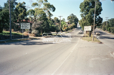 Eltham District Historical Society Inc
Negative - Photograph, Main Road, Eltham, c.Dec. 1983
Road sign advising of proposed reconstruction works of Main Road to install a roundabout at Mount Pleasant Road. Traffic to Lower Plenty and Templestowe to be diverted down Bridge Street (and Bolton Street) effective January 1984. The proposed roundabout did not proceed. Instead traffic islands on Mount Pleasant Road were installed in place of temporary blocked out islands.Film - Kodak CM 400 5079 7 strips, 26 framesinfrastructure, roads, road construction, roundabout, road sign, main road, mount pleasant road -
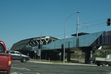 Greensborough Historical Society
Photograph - Digital Image, Marilyn Smith, Mernda Station 2018, 27/09/2018
In 2018 GHS members visited Turner's Bakery in Mernda for lunch and continued on to visit historic sites remaining in the Mernda area. This photograph shows the newly built Mernda Station, part of the railway extension on the old Epping line. This station was opened in August 2018. Mernda is now the end of the line. It is sited on corner Bridge Inn Road and Schotters Road. Mernda is an area of rapid modern growth with a few remaining historic buildings dating from the 19th century.Digital copy of colour photographmernda, mernda historic sites, schotters road mernda, mernda station, bridge inn road mernda -
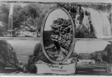 Halls Gap & Grampians Historical Society
Photograph - B/W, C 1930s
The four scenes are 1) Venus Baths [top left],2) Mackenzie Falls[top right],3) The Grand Canyon[bottom left],4)Bridge and Road at Halls Gap[bottom right]. A centre view in an oval frame is The Pinnacle and a scroll with 'Views of the Grampians' written on it appearing below the frame. A scrolled frame runs top and bottom of the four scenes.Photo is a copy of a postcard, depicting four scenes in the Wonderland Range.scenery, grampians ranges -
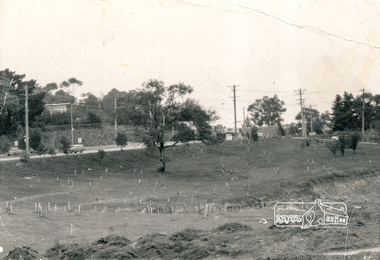 Eltham District Historical Society Inc
Photograph, Alistair Knox Park, Eltham, c.1970, 1970c
View from northwest corner showing survey pegs for trees and two ponds. Main Road has been duplicated. Bridge Street intersection showing the rock wall on the east side of the original Main Road (Maria Street). Burgoyne's Store and Eltham Uniting Church in distance at centre right and Our Lady Help of Christians at centre left.In February 1968 an unknown person took a series of photos from the Eltham Hotel at Pitt Street heading north along Main Road through the shopping centre to just north of Elsa Court covering the length of the section of Main Road which was duplicated shortly thereafter. Shows the condition and environment of the streesscape of Main Road, Eltham immediately prior to the duplication between Pitt Street and Elsa Court through the shopping centre. Also shows a number of shops and businesses that operated at that time.Black and white photographduplication, eltham, main road, bridge street, burgoyne's shop, eltham uniting church, our ladys church, maria street -
 Eltham District Historical Society Inc
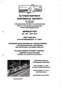
Newsletter, Newsletter, No. 198 May 2011
Contents: • Next meeting, guest speaker; Ross McDonald and Bruce Draper: The McDonalds and the Drapers; two significant Nillumbik families • May Meeting • Eltham Lower Park Walk • Eltham Railway Line • Eltham North Bridge • Room Names at Our Local History Centre • Nillumbik Heritage Strategy • Subscriptions • Office Bearers 2011-2012 • And Also The Shire of Eltham Historical Society was formed in October 1967. The first newsletter of the Society was issued May 1978 and has been published continuously ever since on a bi-monthly basis. With the cessation of the Shire of Eltham in late 1994, the Society's name was revised to Eltham District Historical Society and this name first appeared with issue No. 103, July 1995. The collection of the Society's newsletters provides a valuable resource on the history of the Society's activities, office bearers and committee members, guest speakers and subjects of historical interest pertinent to the former Shire of Eltham and the Eltham District.A4 photocopied newsletter distributed to membersnewsletter, eltham district historical society, shire of eltham historical society -
 Nillumbik Shire Council
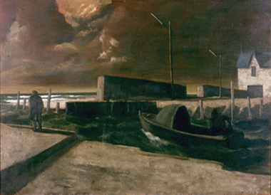
Painting: Rick AMOR (b.1948, Melb. AUS), Rick Amor, Out to Sea, 1993
Rick Amor was a good friend of three times Archibald Prize winner Clifton Pugh, living and working at Pugh's artist colony Dunmoochin, (Cottles Bridge) during the 1980-1990s. Amor made frequent outdoor painting trips with Pugh. His studies of Williamstown and areas around the port fuelled a period of sustained painting in his studio at Dunmoochin. Amor is an artist of national significance who had lived locally in Dunmoochin (Cottles Bridge) during the time of this work's making. This painting was exhibited/entered into the 1993 Shire of Eltham Art Awards. The work is representative of Amor's style and interest in seascapes as subject matter. Oil on linen, seascape painting. A solitary and motionless male figure in an overcoat stands at the edge of a dock/jetty with his hands in his pockets looking out to sea with his back towards the viewer. A motorised boat is moored close by and a white house with a blue roof can be seen in the distance. The figure is engulfed by the landscape and a resounding sense of desolation. A storm is brewing; the mood forecast by dark, heavy and thick ominous clouds, alternately darkening with the approach of night, a polluted haze and rough seas. In red paint, lower right, signed 'RICK AMOR '93'amor, seascape, painting, personal, boat, dramatic, atmospheric, ekphrasis 2015, dunmoochin