Showing 11612 items matching " maps"
-
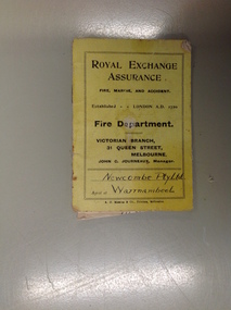 Warrnambool and District Historical Society Inc.
Booklet, Pay Newcombe Pty Ltd
A small booklet relating to fire insurance offered by Royal Exchange Assurance. The schedule relates to the area as outlined on the map in red. Newcombe PTY Ltd operated a timber mill in Warrnambool.A small item with a local social interest.Small yellow covered booklet. Black text. 9 pages with fold out map.Newcombe Pty Ltd on front cover. BCE Warrnambool Vic inside front cover.newcombe pty ltd, warrnambool, royal exchange assurance -
 Department of Energy, Environment and Climate Action
Planimeter (Digital)
The heavy weight is pinned onto the map and the tracing arm is used to follow the boundary to be measured. Reading from the digital scale the area in square centimetres could be measured. Knowing the scale of the mapsheet the figure was converted to areas or hectares Generally at least three measurements were taken to ensure accuracy and precisionPlanimeter used to measure areas from scale maps. Kent Planitron UP103forests commission victoria (fcv), forest measurement, surveying -
 Ballan Shire Historical Society
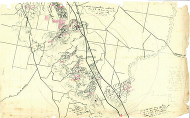
Map - Map. Kerrit Bareet, Department of Lands and Survey, Kerrit Bareet. County of Grant, 08/1944
A map of the Kerrit Bareet area within the County of Grant showing properties and names of owners in 1944.Significant to people researching land usage and ownership. Also those researching families in the area at that time.A map of Kerrit Bareet in the County of Grant. Black printing on buff coloured paper. Details roads, rivers, railways, property boundaries and names of property owners and towns and villages. The map is easily readable although there is some physical damage and that and the borders have been reinforced with sellotape. Shows a Scale in Chains and Price 2/.gordon, bungal, kerrit bareet, lal lal, moorarbool river, warrenheip, bungaree, wallace, moorarbool west -
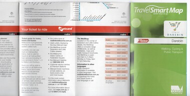 Melbourne Tram Museum
Map, Department of Transport, "TravelSmart Map - Darebin", Jun. 2010
... Maps ...Map - pocket - 28 fold - showing walking, cycling and public transport in the City of Darebin, using a Melway Map base along with public transport information, Metcard, cycling and walking groups. Produced by the Dept of Transport June 2010.trams, tramways, city of darebin, maps, public transport, metcard, metlink -
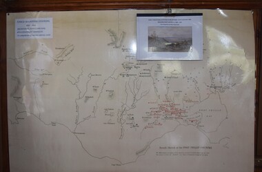 Buninyong Visitor Information Centre
Map, Early Squatters Stations 1837-1838
The map shows rivers and pastoral holdings from 1837 to 1838. Stations occupied around Geelong in 1837 are shown in red and those occupied in 1838 are shown in black. Reproduction of a coloured map shows pastoral stations around the Geelong area from 1837-1940. pastoralism, stations, farming, settlement, squatters -
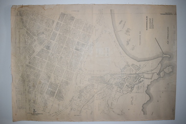
 Bacchus Marsh & District Historical Society
Map, Lerderderg District Proposed Irrigation and Water Supply Trust (B) Plan Showing Proposed Works
The 1886 Irrigation Act in Victoria introduced the first legislation in Australia designed to enable the creation of a detailed scheme for agricultural irrigation. Part of the legislation saw the use of government funds for local irrigation projects. These local projects were managed by local irrigation trusts. The Lerderderg Irrigation and Water Supply Trust was formed in 1890. This map depicts the proposed area of the Trust and proposed works such as channels and weirs.Printed paper map of the proposed Lerderderg District Irrigation and Water Supply area showing proposed works. The map scale is 40 chains + 1 inch. The Lerderderg District lies within the Parishes of Korkuperrumul and Merrimu in the County of Bourke. At the top of the map above its title is the letter 'B; in capital lettering. A series of proposed channels are indicated on the map in red lines. A proposed weir site and alternative weir site are also indicated on the map. irrigation, water supply, lerderderg irrigation and water supply trust -
 Warrnambool and District Historical Society Inc.
Documents Maps (3) - Warrnambool Town Allotments, City of W'bool Parish of Wangoom Country of Villiers, 1948
These maps were produced in 1948 and they contain maps of allotments within the city of Warrnambool, including the Central Business District, up to 1948. The details given on each allotment show the allotment and section numbers, the measurement in acres, the name of the original purchaser of the lot and the date of the first sale. The Warrnambool and District Historical Society owns several copies of these maps but these ones are originals.These three maps are of great significance because they give the names of land purchasers in Warrnambool from the date of the first land sales in 1847. They are a most valuable research tool and can be scanned and photocopied etc.These are three sheets of cream paper pasted on to linen. The sheets have black and white printing and map work. Some of the edges are a little frayed and there is some staining, particularly on the backs of the sheets.‘City of Warrnambool Parish of Wangoom County of Villiers Sheet 1’ ‘City of Warrnambool Parish of Wangoom County of Villiers Sheet 2’ ‘City of Warrnambool Parish of Wangoom County of Villiers Sheet 3’city of warrnambool, warrnambool maps, warrnambool town allotments 1948, land purchases -
 Canterbury History Group
Map - Map of Canterbury, Surrey Hills, Mont Albert and Camberwell, c1930s
... Maps ...Map produced and distributed by White & Clarke Real Estate Agents in Canterbury c 1930canterbury, canterbury road, surrey hills, mont albert, camberwell, maps, real estate agents -
Canterbury History Group
Document - The Grange, 1905
... Maps ...MMBW detailed map of "The Grange" 1905. Includes a short history of the house by Don Gibbcanterbury, the grange, fintona junior school, st. duthies, mont albert road, maps, gibb> don -
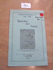 Stawell Historical Society Inc
Book, N.A. McLennan, Yesterday and Today - Ord River Station WA 1895 - 1896 by N A McLennan, 1965
John McLennan's Period as Manager of the Ord River Station. W.A. adjoining Negri Station N.T., was 1895-6. The whole area consisted of 3,365,000 areas under a number of leasesand the then owner was Mr W.H. Osmand, who lived at "The Sycamores" four miles east of Stawell in Victoria. The Distance to Ord W.A. is 4,000 Miles.LIght green card cover with border, inside print and picture of a map Ord River Station W.A. 1895-1896 Yesterday and Today Map of North-East of W.A. Kimberly Ord River area Negri Station N.T. Complied and written by N.A. McLennan December 1965 1965 Victoriastawell, mclennan family -
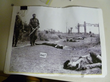 National Vietnam Veterans Museum (NVVM)
Photograph, Soldiers At War
... Maps ...Thirteen copies of photos - Soldiers At War, fifty-six pages of maps and data. Phuoc Tuy Border, shots of casualty, analysis for 1AFT. Twenty-five pages all 1ATF ambushes. Graph cicilian casualities. July 1966 - December 1971.photograph, 1atf, maps -
![Map, Ballarat and Gordons Lane Plan of Land required [for railway line work]](/media/collectors/5e461d8021ea67224c82f2a1/items/676ff3a62c3783fe00b96a8d/item-media/676ff4a42c3783fe00b96cb6/item-fit-380x285.jpg) Bacchus Marsh & District Historical Society
Bacchus Marsh & District Historical SocietyMap, Ballarat and Gordons Lane Plan of Land required [for railway line work]
The railway line from Melbourne to Bacchus Marsh was completed in February 1887. After this date work continued to extend the line to Ballan. This map indicates a portion of land only a few hundred metres west of the Bacchus Marsh railway station which would have been among the first stages of the line to Ballan to have been constructed. This suggests the date of this map to be in the late 1880s.Single page map showing land required for railway line work near Griffith Street, Bacchus Marsh. Scale 10 chains to 1 inch. Hand-written on the map are the exact distances between Bacchus Marsh and Gordons (Gordon) and between Bacchus Marsh and Melbourne as measured from the corner of Maddingley Road and Station Street. Distances recorded are in miles, chains and links. The land required for the railway works is marked in red ink and runs through an area known as Kennedy's Gully. Part of a set of maps which are pasted into a bound volume containing 76 maps or plans in total. High resolution digital image stored on BMDHS computer network. bacchus marsh victoria history, maddingley victoria history, railway lines -
Clunes Museum
Map - DOCUMENTS/MAP, 3 1887. .4 1891
MINING, CLUNES GOLD MINES, MAPS, SECTIONS.1 AERIAL VIEW OF CLUNES AND DISTRICT. COLOUR PHOTOGRAPH LAMINATED. .2 MAP OF MINING AREAS SHOWING EXCISED AREA. No. 9104. MINING DISTRICT OF BALLARAT. PARISH OF CLUNES. COUNTY OF TALBOT. SCALE 4 CHAINS TO AN INCH. .3 MAP OF GOLD MINING LEASE BLOCKS AT CLUNES .4 DRAWINGS OF SECTIONS, CLUNES GOLD MINES. SCALE 400 FEET TO AN NCH. ALL MOUNTED WITH PLASTIC HANGING STRIPS..1 ON BACK. CLUNES 1:25000 .2 ASSORTED HANDWITTEN NOTATIONS. .3 ASSORTED HANDWITTEN NOTATIONS. REPLACE IN DEPT. OF MINING REGISTRARS QUARTER ENDED 30TH JUNE 1887. P. 12.clunes, gold mining, leases, aerial photograph, mine sections -
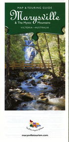
 Marysville & District Historical Society
Map (Item) - Map and touring guide, Murrindindi Regional Tourism Association Inc, Marysville & The Mystic Mountains VICTORIA-AUSTRALIA, 08-2002
A fold out map and touring guide of Marysville and the surrounding district published in 2002 by Murrindindi Regional Tourism Association Inc.A fold out map and touring guide of Marysville and the surrounding district published in 2002 by Murrindindi Regional Tourism Association Inc.marysville, victoria, australia, map and touring guide, mystic mountains tourism, the beeches rainforest walk, lake mountain, cambarville, cathedral range state park, the cumberland, abbey green b&b cottages, anastasia fairytale cottage, ashlar cottage b&b, somerled mountain retreat, baree mudbrick cottages, blackwood cottages, camellia cottage, cathedral view b&b, cottage riverside, crossways country inn, dalrymples guest cottages, esa country ministries, hillcrest, keppels hotel motel, kerami house, lomatia lodge, lyell guest cottages, marylands country house, marysville caravan park, marysville holiday cottages, maryton park, melina cottage, moondai farm b&b, mountain lodge marysville, mount cathedral lodge, mystic mountains holiday cottages, nanda binya lodge, rendezvous on murchison, scenic b&b, the hermitage, tower motel, waratah house, willowbank at taggerty, woodlands of narbethong, keppels, lake mountain resort cafe, lanterns at willowbank, mantirri blueberry farm, marysville country bakery, the old woolshed cafe, clearstream olives, uncle fred & aunty val's old style lolly shop, acheron valley alpacas country store & gallery, bruno's art and sculpture garden, country touch, things of sand & stone, willowbank gallery, marysville auto & hardware, marysville newsagency & general store, marysville visitor information centre, narbethong visitor information centre, gallipoli park, keppels lookout, lady talbot drive, steavenson falls, steavenson river, taggerty river, acheron river, black spur trail riding centre, buxton trout farm, lake mountain resort ski hire, lake mountain ski school, marysville district country club, marysville ski centre, narbethong ski hire, rubicon horse riding, country touch tours, murrindindi regional tourism association inc -
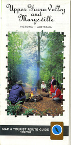 Marysville & District Historical Society
Map (Item) - Tourist map and guide, Warburton Ranges Tourism, Upper Yarra Valley and Marysville VICTORIA-AUSTRALIA, 1997
A tourist map and guide for the Upper Yarra Valley and Marysville produced by Warburton Ranges Tourism and Mystic Mountains Tourism in 1997.A tourist map and guide for the Upper Yarra Valley and Marysville produced by Warburton Ranges Tourism and Mystic Mountains Tourism in 1997.marysville, victoria, australia, tourist map, tourist guide, mystic mountains tourism, warburton ranges tourism, lake mountain, marysville post shop, the marysville museum, bruno's art and sculpture garden, marylands country house, blackwood cottages, dalrymples guest cottages, anastasia's cottage, marysville hotel motel, kerami guest house, the cumberland -
 Marysville & District Historical Society
Map (Item) - Map and touring guide, Murrindindi Regional Tourism Association Inc, Marysville & The Mystic Mountains VICTORIA-AUSTRALIA, 08-2002
A fold out map and touring guide of Marysville and the surrounding district published in 2002 by Murrindindi Regional Tourism Association Inc.A fold out map and touring guide of Marysville and the surrounding district published in 2002 by Murrindindi Regional Tourism Association Inc.marysville, victoria, australia, map and touring guide, mystic mountains tourism, the beeches rainforest walk, lake mountain, cambarville, cathedral range state park, the cumberland, abbey green b&b cottages, anastasia fairytale cottage, ashlar cottage b&b, somerled mountain retreat, baree mudbrick cottages, blackwood cottages, camellia cottage, cathedral view b&b, cottage riverside, crossways country inn, dalrymples guest cottages, esa country ministries, hillcrest, keppels hotel motel, kerami house, lomatia lodge, lyell guest cottages, marylands country house, marysville caravan park, marysville holiday cottages, maryton park, melina cottage, moondai farm b&b, mountain lodge marysville, mount cathedral lodge, mystic mountains holiday cottages, nanda binya lodge, rendezvous on murchison, scenic b&b, the hermitage, tower motel, waratah house, willowbank at taggerty, woodlands of narbethong, keppels, lake mountain resort cafe, lanterns at willowbank, mantirri blueberry farm, marysville country bakery, the old woolshed cafe, clearstream olives, uncle fred & aunty val's old style lolly shop, acheron valley alpacas country store & gallery, bruno's art and sculpture garden, country touch, things of sand & stone, willowbank gallery, marysville auto & hardware, marysville newsagency & general store, marysville visitor information centre, narbethong visitor information centre, gallipoli park, keppels lookout, lady talbot drive, steavenson falls, steavenson river, taggerty river, acheron river, black spur trail riding centre, buxton trout farm, lake mountain resort ski hire, lake mountain ski school, marysville district country club, marysville ski centre, narbethong ski hire, rubicon horse riding, country touch tours, murrindindi regional tourism association inc -
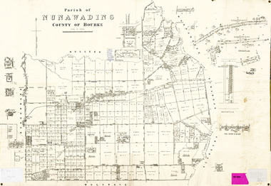 Whitehorse Historical Society Inc.
Legal record - Map, Parish of Nunawading, c1930
... maps ...Office of Lands and survey map, 1864 with many further subdivisions of 1870 onwards added.Office of Lands and survey map, 1864 with many further subdivisions of 1870 onwards added. Boundaries of City of Box Hill included. Note added re Slater's land in Blackburn North. Office of Lands and survey map, 1864 with many further subdivisions of 1870 onwards added. maps, shire of blackburn and mitcham, city of box hill, slater family -
 Queenscliffe Maritime Museum
Book - Royal Atlas 1861, Keith Johnston, The Royal Atlas of Modern Geography, 1861
Atlas of the word in 1861105 page leather bound atlas containing some coloured illustrations of maps of the countries of the world up to 1861. Published by William Blackwood & Sons, 1861. Folio [51x34cm] size with 9 pages of introductory text followed by 48 double-page spread and part coloured maps.non-fictionAtlas of the word in 1861geography, world atlas, keith johnstone -
 B-24 Liberator Memorial Restoration Australia Inc
Map - US World War II multi-coloured map - Philippine Series, No. C-43 Mindanao Series, No. C-44 North Borneo, 1944
Silk and rayon maps were produced by the United States (c. 7.5 million in total), Great Britain (some 1.75 million in total) and Australia during World War II. They were issued to Allied military personnel as part of 'escape and evasion' kits.This map, printed on acetate rayon, is an original US 'escape and evasion' kit map from World War II.A multi-coloured, contoured, double-sided map printed on acetate rayon AAF Cloth Chart - Philippine Series Side 1 - No. C-43 Mindanao Series Side 2 - No. C.44 North Borneounited states of america, silk and rayon maps, world war ii -
 B-24 Liberator Memorial Restoration Australia Inc
Map - US World War II multi-coloured map, Side 1 - No. C-47 South Borneo, Side 2 - No. C-48 West Java, 1944
Silk and rayon maps were produced by the United States (c. 7.5 million in total), Great Britain (some 1.75 million in total) and Australia during World War II. They were issued to Allied military personnel as part of 'escape and evasion' kits.This map, printed on acetate rayon, is an original US 'escape and evasion' kit map from World War II.A multi-coloured, contoured, double-sided map printed on acetate rayon AAF Cloth Chart Side 1 - No. C-47 South Borneo Side 2 - No. C.48 West Javaunited states of america, silk and rayon maps, world war ii, a191 -
Whitehorse Historical Society Inc.
Map, Blackburn and Doncaster, 1950, 1950
... Maps ...Map of part of Blackburn and Doncaster from Morgan's Street Directory, 1950. Advertisement for G.S. Grover, Real Estate Agent, Main Road, Doncaster.Map of part of Blackburn and Doncaster from Morgan's Street Directory, 1950. Advertisement for G.S. Grover, Real Estate Agent, Main Road, Doncaster.Map of part of Blackburn and Doncaster from Morgan's Street Directory, 1950. Advertisement for G.S. Grover, Real Estate Agent, Main Road, Doncaster.maps, blackburn, grover, g.s., doncaster -
Whitehorse Historical Society Inc.
Map, Surrey Hills to Croydon map, c1980
... Maps ...Surrey Hills to Croydon map, Drake & Co Pty Ltd.Surrey Hills to Croydon map, Drake & Co Pty Ltd.Surrey Hills to Croydon map, Drake & Co Pty Ltd.surrey hills, box hill, blackburn, forest hill, vermont, ringwood, mitcham, nunawading, maps -
 Beechworth Honey Archive
Hand-Drawn Map Centred on Armstrong by Frank Lebbell Frost Dec 1916
This is one of the maps drawn by Frank L. Frost while he was beekeeping in North-East Victoria. This particular map may be reference in the "Wooden" Diary on page 11.Hand-drawn map centred on Armstrong, a town 6 miles from Ararat. Details vegetation along Great Western Highway. Drawn with black pen and grey lead on paper. Features are marked in red.hand drawn, hand-drawn, map, armstrong, ararat, frost, beekeeper, beechworth honey -
 Kiewa Valley Historical Society
Map / Chart, Vegetation Map & Guide to Alpine Flora: Hotham, 1982
This poster shows Mt Hotham is on the Victorian High Plains. This poster and map enables the comparison to be made of flora in other areas of the Victorian High Plains e.g.. which was previously known as the Bogong High Plains. This poster has historical and research value as it shows the flora in Mt Hotham area therefore making it significant for people interested in plants. Also for those who would like to compare what plants are still in this area after 1982 and if the cattle grazing, climate change, of bush fires have had on the environment. Thus this poster also has good interpretive capacity of these reasons.Laminated double sided vegetation map and photographic guide to Alpine flora of the Hotham area.hotham. vegetation. plants. flowers. alpine. high plains of victoria. -
 Bendigo Military Museum
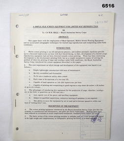
Administrative record - Royal Australian Survey Corps - A simple silk screen equipment for limited map reproduction by LTCOL HM Hall (RASvy) 1967, LtCol HM Hall (RASvy), 6 Feb 1967
This paper deals with the employment of Hand operated Mobile Screen Printing Equipment and its associated cartographic techniques for limited map reproduction and overprinting under field conditions. Written by LtCol HM Hall (RASvy)8 x A4 page document containing typed text, photos and map extractroyal australian survey corps, rasvy, fortuna, army survey regiment, army svy regt, asr, school of military survey, sms -
 Melbourne Tram Museum
Document - Report, Parliamentary Public Works Committee, "Parliamentary Public Works Committee Report Plenty Road, Preston, Tramway Extension Enquiry, 1967
Report contained within a light brown card folder, containing a photocopy of report titled "Parliamentary Public Works Committee Report (including map) on The Plenty Road, Preston, Tramway Extension Enquiry - 1967". Report stapled in top right hand corner, 15 pages examining the extension of the East Preston route to Bolderwood Parade. Map shows extension proposed, bus routes, railway lines, streets - folded into 4.AETA stamp on front and inside sheet and "4E6" in ink on front cover. AETA stamp on the bottom right hand corner of the map.trams, tramways, east preston, new tramway, bolderwood parade, proposals -
 Eltham District Historical Society Inc
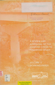
Book, A Review and Appraisal of the Diamond Creek to Ringwood Study, volume 2, working paper, by Loder and Bayly, 1979
Volume 2: Working papers. This report is a review and appraisal of the Outer Ring Road Study Diamond Creek to Ringwood prepared for The Road Planning Liaison Committee by the Joint Road Planning Group for the The City of Doncaster & Templestowe and The Shire of Eltham by Loder & Bayly Planning & Engineering Consultants. "This paper attempts to set a framework for an evaluation of the recommended road link between Diamond Creek and Ringwood." Various perspectives are examined. Includes fold out maps.91 p, maps, 27 cm.melbourne ring road, roads, freeways -
 Bendigo Military Museum
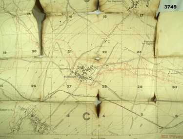
Map - TRENCH MAP, FRANCE WW1, 1917
Areas covered on this map are, “Bullecourt, Reincourt, Hendecourt”. Item relates to William Alexander No 502 AIF. Refer Cat No 3746.3 for his service details.Trench map, France, scale 1:10,000, German trenches in red, trenches corrected to 6.4.1917, Edition 2.map, france, trench -
 Ballarat Tramway Museum
Document, "The Geelong Tramways, A Brief History", late 1950s
... maps ...Document titled "The Geelong Tramways, A Brief History" - by an unknown author, though the map is similar to the one provided in item 9810, in a paper published by the Geelong Historical Society, Investigator magazine, written by John Moore. The article or document looks at the early development of Geelong trams, the start of services, services and operations during the twenties, and thirties, and closure. Notes the appeal by the Barwon Apex Club for the display of a bogie tram. Has a diagrammatic map of the Geelong system on the last page.Yields information about Geelong tramway history and fund raising for the preservation of a bogie tram.Document - 7 quarto pages, stapled in the top left hand corner.tramways, geelong, maps, history, apex club -
 Whitehorse Historical Society Inc.
Document, Orcharding and the Blue moon Cooperative
Typescript history of the Blue Moon Cooperative LtdTypescript history of the Blue Moon Cooperative Ltd also a map indicating the destinations to which fresh fruit was shipped by the Blue Moon Group of companies.Typescript history of the Blue Moon Cooperative Ltdcool stores, blue moon fruit co-operative ltd