Showing 993 items
matching paddocks
-
 Southern Sherbrooke Historical Society Inc.
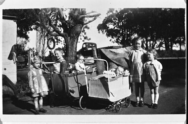
Photograph, Photo - Group of children playing under trees. Hermon children and friends
B&W photo children playing under trees. L-R, Joy Hermon, John Hermon, Lynette Hermon, Elaine Martin, Henny and Cisca. Joy is wearing a long-sleeved dress with a collar, and she has a bow or large clip in her hair. John has a dark shirt and lighter overalls. Lynette, who isabout seven months old, is sitting up in a pram. She has a harness on. Elaine is around three months old and is lying in a wicker pram. Henny and Cisca, two Dutch girls, are wearing gingham dresses and cardigans. Henny's dress has two rows of rickrack on the skirt. In a fenced-off paddock behind the children, a corner of a shed can be seen. There is a tyre swing on a large tree. A dark tray truck is parked on slightly higher ground. Dated c. 1950s. -
 Bendigo Historical Society Inc.
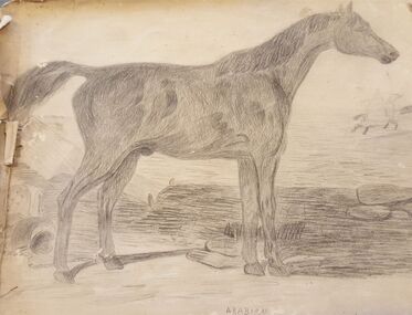
Drawing - Harris Collection: Handmade booklet of drawings
Handmade booklet of black and white drawings. Three pages of heavy brown paper stitched together on short side with cotton thread. The booklet was disassembled for one page to be used in a display. Pages remain separated. The first page has a drawing of a standing dark coloured horse. Beneath the drawing is the word 'ARABIAN". 0453 is written in one corner. In the background is another horse with rider riding away. On the reverse side of this page are some geometric patterns. The second page has a black and white drawing of two ladies in a paddock observing a bull in the distance. They are surrounded by long grass and flowers. On the reverse are several random unfinished sketches. The third page has a drawing of Thos. Strachan's Vineyard, Axedale, 1884. The drawing includes a weatherboard house with a verandah, and a barn close by. Three chimneys are visible. On the reverse are random unfinished sketches. george harris, axedale, drawing, sketches -
 Kew Historical Society Inc
Photograph, J F C Farquhar, Bird's Eye View Looking West, 1891
At the beginning of the 1890s, the Kew businessman and Town Councillor, Henry Kellett, commissioned J.F.C. Farquhar to photograph scenes of Kew. These scenes included panoramas as well as pastoral scenes. The resulting set of twelve photographs was assembled in an album, Kew Where We Live, from which customers could select images for purchase.The preamble to the album describes that the photographs used the ‘argentic bromide’ process, now more commonly known as the gelatine silver process. This form of dry plate photography allowed for the negatives to be kept for weeks before processing, hence its value in landscape photography. The resulting images were considered to be finely grained and everlasting. Evidence of the success of Henry Kellett’s venture can be seen today, in that some of the photographs are held in national collections.It is believed that the Kew Historical Society’s copy of the Kellett album is unique and that the photographs in the book were the first copies taken from the original plates. It is the first and most important series of images produced about Kew. The individual images have proved essential in identifying buildings and places of heritage value in the district.Before true aerial photography became possible, photographers such as J.F.C. Farquhar were compelled to shoot their images from the highest vantage point. Here, it is presumed to be the roof of Xavier College, from which the panoramic view extends west towards the rise of Studley Park. The houses in the foreground face the southern end of Gellibrand Street. Wellington Street is at an angle to the camera with the Queen Street intersection on the near right. The wooden building behind the large horse paddock on the other side of Gellibrand Street is the Kew Recreation Hall, built 1888, demolished 1960. It was reputed to have one of the finest dancing floors in or around Melbourne. The Bowling Green at the rear of the Hall belonged to the Kew Bowling Club. Further west is the Kew Railway Station on Denmark Street, opened to the public in 1887. At this period, much of Studley Park was locked up in large landholdings, dominated by large mansions such as ‘Byram’. Bird's Eye View Looking Westkew illustrated, kew where we live, photographic books, henry kellett, denmark street, kew recreation hall, kew bowling club, wellington street -
 Kew Historical Society Inc
Photograph, J F C Farquhar, Studley Park Road, 1891
At the beginning of the 1890s, the Kew businessman and Town Councillor, Henry Kellett, commissioned J.F.C. Farquhar to photograph scenes of Kew. These scenes included panoramas as well as pastoral scenes. The resulting set of twelve photographs was assembled in an album, Kew Where We Live, from which customers could select images for purchase.The preamble to the album describes that the photographs used the ‘argentic bromide’ process, now more commonly known as the gelatine silver process. This form of dry plate photography allowed for the negatives to be kept for weeks before processing, hence its value in landscape photography. The resulting images were considered to be finely grained and everlasting. Evidence of the success of Henry Kellett’s venture can be seen today, in that some of the photographs are held in national collections.It is believed that the Kew Historical Society’s copy of the Kellett album is unique and that the photographs in the book were the first copies taken from the original plates. It is the first and most important series of images produced about Kew. The individual images have proved essential in identifying buildings and places of heritage value in the district.In this view of Studley Park Road, looking northeast to the Junction, the photographer invites the viewer to participate in a point-of-view that emphasises the elevated, tranquil vantage point of the hill in contrast to the bustling commercial area in the distance. The view emphasises the exclusiveness of Studley Park, with its high fences behind which a number of significant Kew mansions were concealed. Contemporary advertisements for the sale of mansions in Studley Park Road often included fulsome descriptions of their elaborate formal gardens, as well as paddocks for grazing, stabling and dairies. None can be seen here. The use of high, protective wooden pickets to surround the newly planted avenue of elms on the south side of the road appears to be typical of the period. Similar examples can be seen in early photographs of Wellington and Princess Streets.The horse and carriage, selected as a central focus of the view, reinforces the residential, exclusive nature of this part of Kew in the early 1890s. Studley Park Roadkew illustrated, kew where we live, photographic books, henry kellett -
 Clunes Museum
Photograph, 1859
.1.2 BLACK AND WHITE PHOTOGRAPH OF PORT PHILLIP HILL TAKEN CIRCA 1859. .1 HANDWRITTEN ON BACK: PORT PHILLIP MINE AND HILL TAKEN CIRCA 1859 PORT PHILLIP MINE SOUTH SHAFT CLUNES HOTEL IN MIDDLE OF P.P. PADDOCK CLUNES UNITED MINE CRITERIAN MINE CRITERIAN BRIDGE WOOSTERS BALLARAT RESTAURANT, DOES NOT SHOW IN LATER PICTURES PORT PHILLIP MINE FIRST BATTERY PORT PHILLIP HOTEL OPENED IN 1859, CONTINUED UNTIL LATE 1890'S CRITERION HOTEL, FIRST MASONIC MEET UP, BURNT JAN 1871 NEGATIVE OF THIS PHOTO IS AT LATROPE LIBRARY MELBOURNE SIGNED: J CONRAD WEICKHARDT .2 HANDWRITTEN ON BACK: PHOTO OF PORT PHILLIP MINE AND HILL TAKEN ABOUR 1859 OR 1860 THE NEGATIVE OF THIS PICTURE IS AT LATROBE LIBRARY MELBOURNE FROM CAMP PARADE photography, mining, port phillip hill, port phillip -
 Kew Historical Society Inc
Photograph, J F C Farquhar, A View in Studley Park Road, 1891
At the beginning of the 1890s, the Kew businessman and Town Councillor, Henry Kellett, commissioned J.F.C. Farquhar to photograph scenes of Kew. These scenes included panoramas as well as pastoral scenes. The resulting set of twelve photographs was assembled in an album, Kew Where We Live, from which customers could select images for purchase.The preamble to the album describes that the photographs used the ‘argentic bromide’ process, now more commonly known as the gelatine silver process. This form of dry plate photography allowed for the negatives to be kept for weeks before processing, hence its value in landscape photography. The resulting images were considered to be finely grained and everlasting. Evidence of the success of Henry Kellett’s venture can be seen today, in that some of the photographs are held in national collections.It is believed that the Kew Historical Society’s copy of the Kellett album is unique and that the photographs in the book were the first copies taken from the original plates. It is the first and most important series of images produced about Kew. The individual images have proved essential in identifying buildings and places of heritage value in the district.This is the earliest known photograph of the exterior of Byram (later Tara Hall). It shows the original red brick fence, its asymmetrical gate and gateposts, with a large terra cotta gargoyle surmounting the higher of the two. The architect, Edward Kilburn designed Byram in the Arts & Crafts style for the industrialist George Ramsden. Construction began in 1888 and was reputed to have lasted three years. The mansion had frontages to Studley Park Road and Stevenson Street, including gardens laid out with great taste, including pleasure grounds, tennis lawn, fruit and flower garden, and paddock. The size of many of the trees in the garden indicate that many survived from the garden of Clifton Villa, the previous single-storeyed house built on the site by the Stevenson brothers. Byram had views to Melbourne and Port Phillip Bay. The house was demolished in 1960, despite opposition from the National Trust (Victoria), and its gardens subdivided into residential allotments.A View in Studley Park Roadkew illustrated, kew where we live, photographic books, henry kellett, byram, tara hall, goathlands -
 Flagstaff Hill Maritime Museum and Village
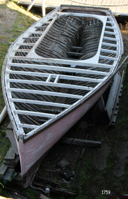
Vehicle - Vessel, Couta boat, Viator, 1890-1920
The historic Victorian ‘couta boat “Viator” was built by renowned boat builder J.R. Jones of Williamstown in Melbourne, between 1890 and 1920. He was one of the early builders of this design. The features of Viator - carvel planked, open cockpit, vertical stem and straight keel, single mast and a pivoting centreboard - are all characteristics of an early Bass Strait ‘couta boat. This has been confirmed by experienced Victorian ‘couta boat restorer Tim Phillips. Viator served as a ‘couta fishing boat in the Warrnambool area until the mid-1930s, then some say she served as a mail ferry across to Portland. Later it was used as a fishing and recreation boat for local families. For years Viator sat in a paddock in East Warrnambool until purchased in 1975 and donated to Flagstaff Hill. ‘COUTA BOATS - The ‘couta design for vessels is believed to have originated at Port Phillip, Victoria, for the purpose of the Barracouta (‘couta) fishing industry, being both fast and seaworthy. , The 'couta fish was an important food fish in Australian waters, supplying Melbourne with plenty of inexpensive fish. VIATORY’S OWNERS - Some of Viator’s history is known: - 1940, registered Port Fairy and owned by G.J. Richards. - 1941-1945, registered in Port Fairy and owned by Jens “Peter” Petersen. - 1950’s “Brusher” Richards of Warrnambool and Port Fairy used it for fishing. - Peter Watson and his son also went fishing in Viator. - Frank Ferrier, boat builder, was an owner (son of ‘La Bella’ hero, William Ferrier) - Arthur Rogers owned Viator too, then sold it to Terry Pridmore and Wayne Moorefield - The Viator was stored in a paddock, unused for years, in Fairmont Avenue, Warrnambool, where it was gradually deteriorating. - 1975 Viator was purchase at a very reasonable price from Pridmore, then donated to Flagstaff Hill Maritime Village. RESTORATION - Shipwright Erik Mikkelsen soon started restoration on the Viator after it arrived at Flagstaff Hill in 1975. In 2006 the Maritime Museums of Australia awarded a grant to Flagstaff Hill Maritime Village to assist with the restoration and renovation of the Viator. Its restoration continues today in the care of Flagstaff Hill’s boat builder. J R. JONES - boat builder The photograph of the EVA MYRL shows the builder J R Jones with his team of workers. The other photograph shows a vessel built by J R Jones' son, J B Jones of Footscray, and his team of boat boulders. The photograph of the EVA MYRL was taken by E. A. Dond---. The other photograph is of the Sturrock Coot, taken a Albert Park Lake in St Kilda.The Viator is the most significant boat in the Flagstaff Hill's fleet, being the last remaining local 'couta boat and one of few existing examples of this craft. Viator received Heritage status with the Australian Maritime Museums Council and is listed on the Australian Register of Historical Vessels in 2006 (ARHV Number: HV000561). Viator was built in Victoria in the early days by renowned boat builder J.R. Jones, and sailed by fishermen for many years, both local and on the coastal waters of Victoria, and was possibly used for the mail service. It is significant for being used for the fishing trade, for government service, perhaps as a mail boat, and for recreation by local families.Vessel, the ‘Viator’, an historic Victorian ‘couta boat, handmade by renowned boat builder This J.R. Jones 'couta boat, the Viator, was built in Williamstown, c.1890-1920. The single mast vessel has a Caravel hull built from New Zealand Kauri, blackwood, with a red gum keel and a jarrah stem and stern. It has a pivoting centreboard. Two photographs are included; one of the builder with his team, the other is of his son J B Jones, with his team. Marked "Viator" Photograph 1759.2: "E. A. Dond---" (indecipherable". Handwritten on back "Grandfather / J R Jones / Built" Photograph 1759.3; sign within photograph "J B JONES / BUILDER / FOOTSCRAY", stamped in the card, bottom right " ----- / MELBOURNE" and handwritten on the back "I think this is Mr Abel Sturrock Coot Albert Park Lake"flagstaff hill, warrnambool, shipwrecked coast, flagstaff hill maritime museum, maritime museum, shipwreck coast, flagstaff hill maritime village, great ocean road, arhv hv000561, arthur rogers, bass strait ‘couta boat, “brusher” richards of warrnambool and port fairy, clinker hull boat, ‘couta crafted boat c 1890-1905, ‘couta fishing boat, erik mikkelsen shipwright, g.j. richards of port fairy, jens “peter” petersen, john lindsay, old mail boat, pivoting centerboard boat, peter watson, single-masted ketch, terry prodmore and wayne moorefield, vessel viator, viator a historical vessel, victorian ‘couta boat, victorian barracoota boat, warrnambool ‘couta boat, western victoria fishing boat, western victoria mail boat, hv000561, australian register of historical vessels, erik mikkelsen, j b jones, j b jones boat builder, footscray, sturrock coot, sturrock, j r jones, j r jones boat builder, williamstown, eva myrl -
 The Beechworth Burke Museum
Audio - Oral History, Jennifer Williams, Mrs Val Mason, 5 January 2001
Mrs. Valerie (Val) Mason (1927-2019) was a local sheep farmer, business-woman, Beechworth shire councillor, and mother to five children. With her husband, Charles, Mrs. Mason developed and managed the Big Valley farm estate, at Everton, which is now part of a vineyard and farm stay. Mrs. Mason was instrumental in introducing a 'paddock to plate' philosophy and business model, opening a butcher shop on the farm in 1973. Concerned with improving infrastructure and developing economic opportunities in the region, Mrs. Mason successfully stood as a local council representative for South Riding in the United Shire of Beechworth, and later become the first woman Shire President in 1979. Mrs Mason was a member of the local Business and Professional Women's Club for 37 years. This oral history recording was part of a project conducted by Jennifer Williams in the year 2000 to capture the everyday life and struggles in Beechworth during the twentieth century. This project involved recording seventy oral histories on cassette tapes of local Beechworth residents which were then published in a book titled: 'Listen to what they say: voices of twentieth century Beechworth. These cassette tapes were digitised in July 2021 with funds made available by the Friends of the Burke.Mrs. Mason's story is historically significant for understanding economic and social changes in the Beechworth region during the latter half of the twentieth century. As a council representative, issues such as road and infrastructure modernisation and the transition from traditional government employment sectors, like Beechworth's care institutions, were challenges for local government. As a farmer and local employer, Mrs. Mason's story is testimony to the region's economic diversification as businesses like Big Valley farm shop helped shape the region's contemporary character. Mrs. Mason was among the first women to broach the traditionally all-male Beechworth Council Chambers and her story is socially significant for understanding the changing role of women in rural and regional Australia. This oral history recording offers interpretive capacity for social history themes and may be compared with other oral histories in the Burke Museum's collection. This oral history account is socially and historically significant as it is a part of a broader collection of interviews conducted by Jennifer Williams which were published in the book 'Listen to what they say: voices of twentieth-century Beechworth.' While the township of Beechworth is known for its history as a gold rush town, these accounts provide a unique insight into the day-to-day life of the town's residents during the 20th century, many of which will have now been lost if they had not been preserved.This is a digital copy of a recording that was originally captured on a cassette tape. The cassette tape is black with a horizontal white strip and is currently stored in a clear flat plastic rectangular container. It holds up 40 minutes of recordings on each side.Mrs Val Mason /listen to what they say, beechworth, oral history, burke museum, working women, trail blazers, farm to plate, farm shop, paddock to plate, woman farmer, united shire of beechworth, rural and regional women, beechworth's first woman shire president, women in leadership positions, women leaders, australian settlement history, settler societies, victorian gold rush, heritage tourism, culinary tourism, regional land use, indigo winery, farm stay, social history -
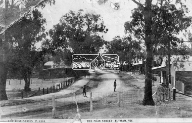 Eltham District Historical Society Inc
Negative - Photograph, Rose Stereograph Company, The Main Strteet, Eltham, Vic, c.1923
The Rose Series P. 4344 postcard. Similar view to SEPP_0609 taken from near Dudley Street looking north but significantly later in time with numerous stores now constructed on the eastern side south of Pryor Street in what was once Haley's Paddock. Luther Haley sold his bakery store in 1917 and the roof now sports advertising signage for Electrine Candles, presumably coincident with the period of ownership by Hannah Lloyd from 1917 to about February 1920 or Lee’s Railway Store (Messrs J.R. & N.E. Lee 1920-Sep 1922). A boy and a man are standing in the road and the ghost image of three people walking towards them on the footpath just past the store. Ernie Andrew’s combined newsagency and haberdashery/clothing shop with advertising for "The Age" is present at the corner of Arthur Street, on the opposite corner would be the Bootmaker's shop (F. Butterworth, succeeded in 1922 by G.H. McDonald) and William J. Capewell's Butcher shop, second building from right (relocated from in front of the railway station in 1910). North of the News Agency is believed to be Horace H. Clark’s Land and Estate Agency which had also relocated across the road.This photo forms part of a collection of photographs gathered by the Shire of Eltham for their centenary project book,"Pioneers and Painters: 100 years of the Shire of Eltham" by Alan Marshall (1971). The collection of over 500 images is held in partnership between Eltham District Historical Society and Yarra Plenty Regional Library (Eltham Library) and is now formally known as the 'The Shire of Eltham Pioneers Photograph Collection.' It is significant in being the first community sourced collection representing the places and people of the Shire's first one hundred years.Digital image 120 format B&W negative (copy of original postcard)shire of eltham pioneers photograph collection, eltham, main road, bootmakers, butcher, dudley street, electrine candles, eltham town centre, hannah lloyd, lloyd's general store, newsagency, pryor street, rose series postcard, shops, william james capewell, ernie andrew, f. butterworth, g.h. mcdonald, haley's paddock, j.r. lee, lee's railway store, n.e. lee, rose stereograph company -
 Orbost & District Historical Society
black and white photographs, 1980s? (winter months)
All photographs seem to have been takenfrom the Telecom tower on the corner of Browning and Wolseley Streets in Orbost 3259.1 is a view of the Orbost township looking north-east. The swimming pool and bowling club can be seen in the foreground. 3259.2 is aview looking north-west and showing the tennis courts and clubhouse, the Recreation Reserve oval, the Youth Centre, Historical Museum, Municipal Offices, Senior Citizens clubrooms with the fire station in the foreground. 3259.3 is a view looking south with the Shire of Orbost Municipal offices and Ruskin Street in the foreground. Munro Street can be seen running from Ruskin Street to St Joseph's School in the middle distance. Lochiel Park oval, Lochiel House, the Snowy River and highway bridge are in the background. 3259.4 is a view looking south showing the Club Hotel, C.B.C. Bank in the middle distance and Hoffman's paddock (Forest Park) and the Snowy River beyond. 3259.5 is a view looking north-east over houses. 3259.6 is aview over the main street, Nicholson Street.showing the main shopping precinct. Shop signs for Permewans, Williams Shoes, F.B. Dicken and Orbost Bakery can be seen. 3259.7 is a view looking south west and shows Forest park and beyond towards Bete Bolong.These photographs are detailed pictorial records of the township of Orbost.Seven black / white photographs taken from above a township. Chimney smoke can be seen in the photographs.orbost-township-1980s aerial-photograph-orbost -
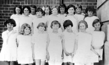 Surrey Hills Historical Society Collection
Photograph, Chatham State School Grade 2 1928, 1931
Chatham School, located in Weybridge Street Surrey Hills, was opened on 1 August 1927 following pressure from local residents as nearby schools (Balwyn, Mont Albert & Surrey Hills) were all over-crowded. This followed a surge in development following WW1. Land in surrounding streets was sub-divided. This included part of John Butler Maling (Jnr)'s small farm bounded by Banool Road, Wharton Road, Weybridge Street and Whitehorse Road. An area surrounding his home, 'The Willows' was retained and not sold until after he died in 1931. leased by Mr John Butler Maling in 1861. Three acres of his land were purchased by the Education Department. Some of the early students have referred to Chatham’s land as Mr Maling’s bull paddock. Some of the original yellow box trees remain on the property. The most significant of these is now called the Friendship Tree. On 1 August 1927 212 students were enrolled; Ralph Rae was one of these. The school was official opened on 15th February 1928. The school number is 4314. Front row centre is Jocelyn Cerini who married Ken Hall, another Chatham student. A black and white photograph of a group of Grade 2 female students from Chatham State School. They are dressed in white.schools, chatham state school, clothing and dress, primary schools, john butler maling (jnr), ralph rae (mr), jocelyn cerini (miss), jocelyn hall (mrs) -
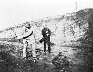 Surrey Hills Historical Society Collection
Photograph, Surrey Hills Golf Club - the cutting in (now) Whitehorse Road, 1905, 1905
Reproduced by permission of Mr John Arnold from his book: "The Riversdale Golf Club - a history, 1892-1977." Copyright to book: Riversdale Golf Club. Surrey Hills Golf Club operated from 1892-1908 then moved and became Riversdale Golf Club. The game was played across paddocks from Trafalgar Street, Mont Albert to Whitehorse Road and down Victoria Crescent to where Box Hill TAFE is now located in Elgar Road. There were problems with cows eating the tee flags! The clubhouse still exists as 30 Trafalgar Street. The men are standing on what is now Whitehorse Road in the cutting which can still be seen near the Box Hill Motel. Walter John Carre Riddell: Born c1859; died 12 March 1930; unmarried. Father came from Riddell in Scotland and took up land at Riddell's Creek, near Gisborne. W J Carre Riddell was educated at Melbourne Grammar, graduated in law from Melbourne University in 1882 and practised law until 1907. MLA for West Bourke for 17 years. Chairman of MMBW from 1907 until retirement in 1927. Versatile sportsman. REF: Obituary in Trove - The Argus, 13 March, 1930, p8.The image is significant for its association with Walter John Carre Riddell who was a significant identity in early 20th century Melbourne. His was well-known for his sporting prowess. In early life he was a keen footballer, cricketer and tennis player. In his later years he took up golf. Was President of Royal Melbourne Golf Club and Chairman of the Victorian Golf Association. The 'coffin hole' was a notoriously difficult position to play out from.Black and white photo of 2 men, one swinging his golf club; the other carrying a golf bag and watching. They are dressed in suits and hats and are standing in a cutting, the face of which shows rock strata."W. J. Carre Riddell playing out of the coffin, 1905."sports grounds, surrey hills golf club, riversdale golf club, jon arnold, w j carre-riddell, walter john carre riddell -
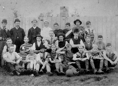 City of Kingston
Photograph - Black and white, c. 1908
Australian rules football began being played on a regular basis in Cheltenham in 1890. Teams would not only play locally but travel by train fairly long distances, such as to Ballarat, for the day, play a game, turn around and come home. The Cheltenham home games were played on a paddock on the corner of Park and Charman roads in Cheltenham. In 1907 the Cheltenham progress committee made an application to the board of land works for land in Weatherall Road for recreational service to the public. That application was received and granted, then developed where Cheltenham Recreational Reserve now stands. The ground was opened in 1909 and the first Cheltenham side entered in the newly formed Federal Football League along with seven other foundation members, Mordialloc, Mentone, Moorabbin, Frankston, Glenhuntly, Elsternwick, and Ellindale. The grand final for that year, 1909 was a hard encounter between Cheltenham and Ellindale with Cheltenham coming out victors, thus becoming the inaugural Federal Football League premiers. The Federal Football League (FFL), also known simply as the Federal League, was an Australian rules football competition in the south-eastern suburbs of Melbourne, Victoria. The competition was in existence from 1909 to 1981 and was regarded as one of the strongest metropolitan leagues in Melbourne.Black and white image of the players and officials of the Cheltenham Football Club. Back (left to right) G Puttick, Franklyn (sic), Unkown, Unknown, C Corstorphine, D Arland, Dave Hughes, H Bryant, Centre: T Elliott, S Parsons, F Judd, H Foreman, N Corstorphine, J McCormack, S Chandler, H Orr. Front: H Clayton - no other names recorded. The players are wearing what appears to be a range of club jumpers, with some in street wear. Some players seated in the front row have mud visible on the soles of their shoes, indicating they may have already played a gam. The ball on the ground in front of the group is round.Round red sticker on reverse with handwritten text: X10 Handwritten in blue ink: A11, with a circle around it Handwritten in red ink: 50%sport, football, cheltenham, teams, federal football league -
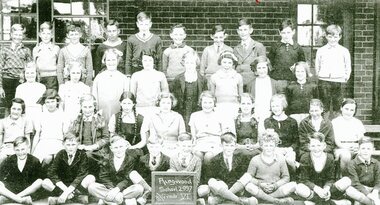 Ringwood and District Historical Society
Photograph, Ringwood State School - Grade 6, 1937, 1937
Black and white photograph"Attached to photograph" Back Row- L to R: Edward Flynn, Bruce Graham, Graham Morgan, ?, ?, David Allan, Ken Ward, ?, Arthur Gillespie, Ken Manning. 2nd Row- L to R: Ellen Crouch, Val Anderson, Helen Bond, Elvie Hancy, Doreen Lloyd, Phylis Reardon, Valma Bisset, Bernice Dixon. 3rd Row- L to R: Patricia Mathews, Betty Stoney, June Parker, Lorna Hill, Betty Reed, Hazel Morgan, Betty Adolphson, Jean Smith, Kath Hamson, Dorothy Fyfe. Front Row- L to R: Frank Lloyd, Walter Hazelwood, Rupert Shearer, ?, Lloyd Holmes, Milton Blood, Bob Seeby, Don Martin, Bob Sievers, Edward Jackson. Teacher: Miss Paddock -
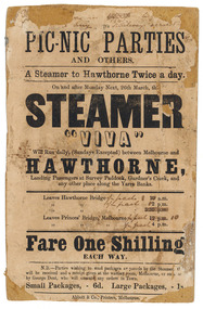 Parliament of Victoria
Flyer for the steamer Viva, Abbott & Co., Printers, c.1860
The "Viva" was a steamboat operated by George Dent that ran on the Yarra River between Princes Bridge and Hawthorn Bridge from 1860-1861. Printer flyer pasted onto cardboard advertising ferry services between Melbourne and Hawthorne [sic]. Corrections to ferry departure times are in black handwritten ink. Flyer has losses around edges and stains from 'blue-tack' verso. Black ink, printed recto: "PIC-NIC PARTIES/ AND OTHERS./ A Steamer to Hawthorne Twice a day./ On and after Monday Next, 26th march, the/ STEAMER/ "VIVA"/ Will Run daily, (Sundays Excepted) between Melbourne and/ HAWTHORNE,/ Landing Passengers at Survey Paddock, Gardner's Creek, and/ any other place along the Yarra Banks./ Leavers Hawthorne Bridge 10 a.m./ 2 p.m./ 5.30 p.m./ Leaves Princes' Bridge, melbourne 12 p.m./ 4 p.m./ Fare One Shilling/ EACH WAY./ N.B.-Parties wishing to send packages or parcels by the Steamer th(?).../ will be received and a receipt given at the waiting room, Melbourne, or on board.../ by George Dent, who will execute any orders in Town./ Small Packages, - 6d. Large Packages, - 1s/ Abbot & Co., Printers, Melbourne.viva steamboat, dent, george, hawthorne, yarra river, princes bridge, melbourne, survey paddock, gardner's creek -
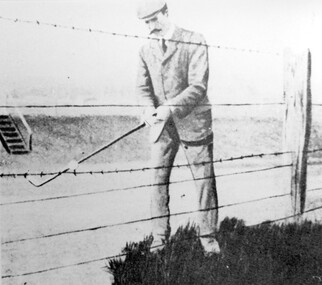 Surrey Hills Historical Society Collection
Photograph, Harry Culliton at Surrey Hills Golf Club
Reproduced by permission of Mr John Arnold from his book: "The Riversdale Golf Club - a history, 1892-1977." Copyright to book: Riversdale Golf Club. Surrey Hills Golf Club operated from 1892-1908 then moved and became Riversdale Golf Club. The game was played across paddocks from Trafalgar Street, Mont Albert to Whitehorse Road and down Victoria Crescent to where Box Hill TAFE is now located in Elgar Road. There were problems with cows eating the tee flags! The clubhouse still exists as 30 Trafalgar Street. The Surrey Hills Golf Club was founded by Mr Hugh W McLeod in 1894. The first president was Mr A W Harston. Mr William Meader was the first honorary secretary and the club champion for several years. Another notable identity was Mr. Harry Culliton, who contributed golf notes to "The Argus" for many years. Harry Culliton (clerk; later bank manager) married Christina Mary Rothwell of Surrey Hills in 1897. They initially live in Canterbury Road before moving to 'Bayview' in Harding Street. They had 3 sons. The eldest Kenneth Rothwell Culliton married Molly Fanny Arthur in 1940. They continued to live in 'Bayview'. Molly was a foundation member of the Surrey Hills Historical Society.The image is significant in documenting the Surrey Hills Golf Club, no longer in existence, but also members of early Surrey Hills families. Black and white photo showing a barbed wire and post fence behind which stands a man, identified as Harry Culliton. He is wearing a suit, cap and a tie. He sports a large 'handle-bar' moustache and is gripping an iron golf club, preparing to strike a golf ball which is impaled on the barbed wire.Caption: "Harry Culliton playing from the barbed wire where his ball was impaled on the fence on the side of the coffin. To his opponent's dismay he managed to land the ball near the green and get down in two for a half."sports grounds, surrey hills golf club, riversdale golf club, clothing and dress, john arnold, harry culliton -
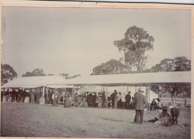 Sunbury Family History and Heritage Society Inc.
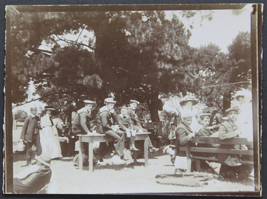
Photograph, Horse Racing, c1900 - 1910
The people in the photograph were enjoying a day out at a Sunbury race meeting some time in the early 1900s. Races at Sunbury began in 1886 with the establishment of the Sunbury Racecourse that was located along Racecourse Road on a section of the Rupertswood Estate on land consisting of six furlongs and two straights. The site included a patron’s stand, saddling paddock, bookmakers’ enclosure, two bars, a committee room, judges box, stables, toilets, six entrance gates and ticket boxes. Special trains from Melbourne brought patrons and horses to the Sunbury race meetings. A report in the Melbourne Argus newspaper in 1922, stated that city taxi drivers came out to Sunbury to drive patrons to the racecourse, which was located about 3 kms from the Sunbury station. Some time however, between 1886 and 1901, there was a period when the racing club had been inactive. A meeting was called in 1901 to restore the club’s activities. With a substantial loan from Mr. Clarke the committee was able to organise the installation of a turnstile, perimeter fencing and irrigation of the course by a windmill that pumped water from a recently constructed dam that was on the estate. The club continued to function until 1942, during World War 2, and did not resume activities after the end of the war. The land was eventually sold for housing development. The Sunbury Race meetings were popular with the racing fraternity not only in the district but further afield and were deemed sufficiently important to run special trains from Melbourne to Sunbury on Race days.A non-digital sepia photograph with a strong cardboard backing of a crowd of people dressed smartly for a day out at the races. Most of the spectators are seated in a long marquee. Three men on the RHS are looking at a horse that is lying on the ground.On the back of the card there are scribbled notes and numbers which seem to indicate the photograph has been used for a publication at some time.sunbury race meetings, sunbury race course, racecourse road -
 Ballarat Tramway Museum
Slide - 35mm slide/s - set of 11, Eldon Hogan, mid 1960's to early 1970's
Set of 11 Agfa Plastic mounted slides - from the Eldon Hogan collection - featuring an ARE tour with Nos. 21, 29 and 25 to Bendigo, mid 1960's. Scanned on the Canon scanner at the depot 15/12/1971 at the time of the installation of the scanner. .1 - four trams at Charing Cross - includes 19 and 25. .2 - 21 and 25 at the depot junction. .3 - 21 and 29 Quarry Hill route? .4 - 29 ditto .5 - 24 at Golden Square terminus - photo taken from the city side - note all the little shops and buildings on the left hand side of the photograph. .6 - 29, 21 and 25 at Eaglehawk .7 - 29 - side on view - Eaglehawk line? .8 - ditto with 21 .9 - 29 - North Bendigo line? - side on view .10 - 29 and 21 - vacant paddocks - Eaglehawk line .11 - 29 crossing the railway overbridge, Eaglehawk line, in bound. Trams have SEC roof advertisements. tramways, trams, bendigo, eaglehawk, charing cross, golden square, tram 21, tram 29, tram 25, tram 19 -
 University of Melbourne, Burnley Campus Archives
Plan, [Historical Maps of Richmond Park], 1862-2000
(1) Proposed reserve for Horticultural & Experimental Garden in the Survey paddock Richmond. R.19A (1865). Shows Swan Street Extension. Gazettals 1877, 1887. (2) As (1). Half of map only Annotation by A. Purchas, 9 October, 1862. (3) Plan of Richmond park. A.L. Martin Authorised Surveyor, 31st August, 1872. [Dept. of lands & Survey Melbourne, J. Noone, 6th September 1872.] Map in 4 sheets. (4) Richmond Park. Surveyed by Geo. Black, Authorised Surveyor 13.8.91 (2 copies). (5) [Richmond Park] Shows road alignments gazetted 1871 & 1881 (part copy only - Neg. 18375). (6) City of Richmond Parish of Jika Jika County of Bourke. Department of lands & Survey, 1919 (annotations i.e. Melb. City Link, Amrad, etc. to 1994.) (7) Burnley gardens, 2000. Produced by P. Tulk, Institute of Land & Food Resources, Burnley College, 2000 (re area proposed for heritage listing.)richmond park, survey paddock -
 The Beechworth Burke Museum
Audio - Oral History, Jennifer Williams, Desmond (Bill) Thomas, 25th May 2000
Desmond (Bill) Thomas moved to Beechworth when he was one year old. He was born in 1923 and his family moved to Beechworth in 1924. His father was offered a job in Beechworth as a leather tanner. His first job was in the Tannery in Beechworth. However, in 1938 he was involved in a accident at the Tannery that resulted in him losing his arm. The Zwar Brothers acquired the Tannery in 1877 and it operated until 1961. His interests included bushwalking and nature. When he was younger he would often go ferreting instead of going to school. His favorite place to visit was near Stanley. This included Zwar's paddock and Eldorado. One of his first memories was when he went to Sunday School at the Methodist Church. He remembered Miss Peach as the Methodist Superintendent. He eventually had to leave that Sunday School because of his behavior. This oral history recording was part of a project conducted by Jennifer Williams in the year 2000 to capture the everyday life and struggles in Beechworth during the twentieth century. This project involved recording seventy oral histories on cassette tapes of local Beechworth residents which were then published in a book titled: Listen to what they say: voices of twentieth century Beechworth. These cassette tapes were digitised in July 2021 with funds made available by the Friends of the Burke.Desmond (Bill) Thomas' oral history has important historical significance for the local Beechworth region. The Zwar Brother's Tannery was a large part of Beechworth and had a long history. Both Mr Thomas and his father has contributed to this history because they both worked there. Mr Thomas' both of the bush and nature demonstrates the history of ferreting and bushwalking in this region. Desmond (Bill) Thomas has made many contributions to his community but also the history of Beechworth. This life tells us many things about the struggles and joys of living in and around Beechworth. This oral history account is socially and historically significant as it is a part of a broader collection of interviews conducted by Jennifer Williams which were published in the book 'Listen to what they say: voices of twentieth-century Beechworth.' While the township of Beechworth is known for its history as a gold rush town, these accounts provide a unique insight into the day-to-day life of the town's residents during the 20th century, many of which will have now been lost if they had not been preserved.This is a digital copy of a recording that was originally captured on a cassette tape. The cassette tape is black with a horizontal white strip and is currently stored in a clear flat plastic rectangular container. It holds up 40 minutes of recordings on each side.Desmond (Bill) Thomasleather tanner, leather, beechworth tannery, tannery, tannery accident, bushwalking, bushland, nature, ferreting, school, sunday school, beechworth methodist church, church, baptist church, beechworth, oral history, recording, 1924, listen to what they say: voices of twentieth century beechworth, listen to what they say, jennifer williams, burke museum, zwar brother's beechworth tannery, zwar bros. tannery -
 Eltham District Historical Society Inc
Map (item) - Sales Brochure, Plenty Township Estate and Bryn Teg Hill's Estate, Coghill & Haughton, Melbourne, c.1924
Plenty Township Estate "The rapid growth of Greensborough and the great traffic development on the main road between Heidelberg and Eltham augurs well for Plenty Township Estate. Already a Store, Post Office and State School have been started, and the activities of the Local Progress Association will help the district forward considerably. Within walking distance of the Montmorency and Greensborough stations." Bryn Teg Hill's Estate "Better known as "The Old Sand Hill, "within walking distance of the Montmorency and Greensborough railways stations." "Some few years back Mrs Thomas subdivided portion of the Sand Hill Paddocks, and the areas sold have been settled and many converted into charming outer suburban garden homes with cultivation and orchard plots. The south-eastern slope gives the land a grand outlook over the Yarra Valley on to the Dandenoings, and the are is very picturesque and homely." "A number of the blocks contain large deposits of valuable building sand, which should prove good speculation in view of the forecast for further rapid home development along the Eltham Suburban Electric Service." Sand Hills Road (Old Eltham Road) Date estimated as c.1924 - Electricification of railway line to Eltham referenced on map occured April 1923 and Mrs Mary Thomas died August 1925. Her home Bryn Teg became part of the Heidelberg Golf Club in 1927.The establishment of Lower Plenty as a suburban growth area supported by easy commuting facilitated by the elctrification of the Eltham railway linebonds road, bridge, bryn teg hill's estate, coghill & haughton, eltham road, heidelberg golf club hotel, houses, lower plenty, lower plenty bridge, lower plenty road, main road, plenty hotel, plenty river, plenty township estate, real estate agent, sales brochure, sand hills road, the old sand hill, sand hill paddocks, woodfull road, old eltham road, bryn teg, mrs m thomas -
 Eltham District Historical Society Inc
Photograph, Peter Pidgeon, Grave of William MacMahon Ball and Katrine S. Ball, Eltham Cemetery, Victoria, 5 April 2021
William MacMahon Ball (‘Mac’ Ball) was Professor of Political Science at Melbourne University from 1949 to 1968, having lectured there since 1923. He became known as an ABC commentator on international affairs from the early 1930s to the early 1960s. Between 1940 and 1944 he was Controller of Overseas Broadcasting (which later became Radio Australia). In 1945, he was political consultant to the Australian Delegation at the conference leading to the establishment of the United Nations, and in 1946 was the British Commonwealth Representative on the Allied Council during the post-war occupation of Japan. Mac and his wife Katrine (plus daughter Jenny) came to Eltham in 1942, and in 1945 moved into an old timber cottage at the eastern end of York Street. With help from Alistair Knox, Sonia Skipper, Gordon Ford and John Harcourt, the house was totally renovated to become an early example of Eltham mud-brick. Mac died in 1986 and is buried in Eltham Cemetery with Katrine. Part of their land backing onto Bridge Street was donated to Eltham Shire Council and is now a reserve called MacMahon Ball Paddock. In Loving Memory W. MacMahon Ball A.C. 29. 8. 1901 – 26. 12. 1986 Also Katrine S. Ball 1st Nov. 1899 to 29th Oct. 1991 Loved wife of Mac. Ball Mother of Jenny Grandmother of Bronwyn, David and Michael Much belovedBorn Digitaleltham cemetery, gravestones, katrine s. ball, william mcmahon ball -
 Eltham District Historical Society Inc
Photograph, Peter Pidgeon, Grave of Sarah and Phillip Shillinglaw, Eltham Cemetery, Victoria, 5 April 2021
Philip Shillinglaw and his wife Sarah came to Eltham in 1882. Their property "Wattle Brae" originally encompassed present-day Eltham Central Park and part of Eltham Library, extending north to include Andrew Park and the site of the railway station. An early photo shows that much of it was planted for crops. They also had cows; in 1913 Philip wrote to the local paper complaining about an earlier report that one of them had been killed on the railway line. "I give an emphatic denial to the report. It is not true." Their house Shillinglaw Cottage (built by George Stebbings) still exists, though it was moved with funding from local residents in 1963-64 when faced with demolition to make room for new Council Offices. Philip was actively involved with the Methodist Church as preacher, Church Steward and Sunday School teacher. A Sunday School picnic and a sports carnival were held on his paddock. Eight of his children attended Eltham Primary School. In 1908 he ploughed part of the schoolyard (possibly for use as a garden) free of charge. When Philip died in 1914, his funeral was described as one of the largest ever seen in Eltham. He and Sarah are buried in Eltham Cemetery. In Loving Memory of Sarah Ann Shillinglaw Died 10th Dec. 1891 Also Phillip Loved husband of above Died 18th Aug. 1914 Sweet BestBorn Digitaleltham cemetery, gravestones, phillip shillinglaw, sara ann shillinglaw -
 Mission to Seafarers Victoria
Photograph - Photograph, Sepia, Mr and Mrs Gurney Goldsmith, Picnic at Orchard House, Cup Day 1909, 2 Novembre 1909
This photograph depicts a picnic for Cup Day (Tuesday 2 November 1909) organised by the Mission and the LHLG members at Orchard House. The property belongs to Mr George Higgins, engineer and his wife, Beatrice who was the LHLG Malvern branch secretary. Beatrice nee Shuter was the daughter of Charles Shuter. In the Punch published on 11 November 1909, we could read: "The pretty garden of "Orchard House," and the paddock adjoining (kindly lent by Mr. and Mrs. Singleton), was the scene on Cup Day of a most successful sailors' picnic, when Mr. and Mrs. George Higgins and the Malvern members of the Ladies' Harbour Lights Guild entertained some 110 sailors from the Royal Navy and Merchant Service. A football match, sports, and "costume" races were indulged in by the more active members of the party, while others enjoyed the unusual pleasure of sitting on the green grass under the trees. Mrs. MacLeod, Mrs. Knight, Mrs. Simon Fraser, Mrs. H. B. Higgins, Mrs. Albert Keep, Miss Ethel Godfrey, the Misses Wollaston, and a number of other ladies assisted to wait on the "tars." One "Jack," from H.M.S. Cambrian, voted it the "nicest day he had had since leaving the Old Country." Hearty cheers for the kind hostesses closed the proceedings. The evening was spent at the Institutes of the Missions to Seamen on the Australian Wharf and at Port Melbourne respectively, where prizes were distributed to the successful competitors. "Small monochrome photograph1909, malvern, cup day, mr george higgins, mce, beatrice elizabeth higgins (nee shuter), h.m.s. cambrian, ethel augusta godfrey, orchard house, ina higgins, rica godfrey, rita godfrey, reverend alfred gurney goldsmith, picnics, social events, frederica godfrey, entertainments, sailors, seafarers, seamen, goldsmith album -
 Glen Eira Historical Society
Album - Album page, Glen Eira Road, Circa 1972
This photograph is part of the Caulfield Historical Album 1972. This album was created in approximately 1972 as part of a project by the Caulfield Historical Society to assist in identifying buildings worthy of preservation. The album is related to a Survey the Caulfield Historical Society developed in collaboration with the National Trust of Australia (Victoria) and Caulfield City Council to identify historic buildings within the City of Caulfield that warranted the protection of a National Trust Classification. Principal photographer thought to be Trevor Hart, member of Caulfield Historical Society. Most photographs were taken between 1966-1972 with a small number of photographs being older and from unknown sources. All photographs are black and white except where stated, with 386 photographs over 198 pages. From Glen Eira Heritage Management Plan 1996 by Andrew Ward: Since 1990, valuable historic houses to have been demolished include "Noris", later "Quethiock", and "Koala" (1875) at 34 Balaclava Road, "Urandaline", later Samford private hospital at 510 Glen Eira Road, and No. 9 Lempriere Avenue. When the Caulfield Tramway Company opened its single line horse tramway along Glen Eira Road to Caulfield station in 1889, the eastern end of this road passed through open paddocks and alongside "Urandaline", a charming late Victorian villa residence with comer pinnacle roof, demolished in 1995.Page 59 of Photograph Album with five photographs, one portrait of the exterior of a house on Glen Eira Road, the other four are photos of sections of advertising materials for Urandaline Estate.Hand written: 508 Glen Eira Road [under top left photo] / 58 [bottom left] trevor hart, glen eira road, caulfield north, urandaline, urandaline estate, horse tram, land subdivision, real estate advertising, verandahs -
 National Wool Museum
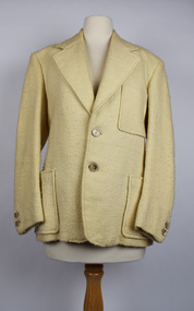
Clothing - Jacket, 1978
The wool for this jacket began on the back of two sheep many kilometres apart. The first fleece for the warp was shorn from a single Merino at Currotha in Moree, NSW. The wool was 21-22 micron and the bloodline is a cross between Bundemar, Rossmore and Eural. The second sheep that provided wool for the weft was shorn in Beaufort, Victoria. It was a single Corriedale fleece shorn at Niawanda. The distance between these two towns is approximately 1250kms; a 15-hour car ride between paddocks. The two fleeces were spun and weaved together by the donor’s mother, Marjorie Allnutt. A level of talent is required to spin Merino fleeces. It is easier to spin cross bred wool, such as Corriedale, because it is less dense and much easier to comb, card and then tease out for a spinning wheel. The donor Philip Allnutt had a suit tailored out of the completed fabric at Ravensdale J & Son, 37 Swanson Street, Melbourne. The tailor was then a member of the Master Tailors Federation of Victoria. The business closed around 1986. Adding to the jacket’s story is its relationship to the household board game “Squatter”. Marjorie Allnutt was the sister-in-law of Robert Crofton Lloyd, the inventor of the wool themed boardgame. With more than 500,000 games sold in Australia as of 2007, it is the most successful board game ever produced in the country. The original “Squatter” board game is located within the National Wool Museum’s Collection. Philip Allnutt donated the Jacket to the National Wool Museum Collection in 2021. Cream singled breasted jacket with a narrow overlap and one column of buttons for fastening. The jacket features notched lapels of a medium width and two buttons of a cream & brown marble. The jacket has three visible pockets. A jetted pocket with no flap is on the right breast. A further two jetted no flap pockets finish an inch above the hem, on either side of the opening. Internally, the jacket features a further two pockets and a white silk lining for comfort. At the cuffs, the jacket utilises another 2 buttons of the same cream & brown marble.merino, currotha, moree, nsw, niawanda, corriedale, beaufort, victoria, hand spun, hand weaved -
 Kew Historical Society Inc
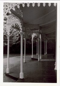
Photograph - Verandah of 'Wimba', 235 Cotham Road, John T Collins, 1979
Although probably built some time earlier, the first mention in the Rate Books of the property later known as 'Wimba Lodge' appears in the entry for 1870 when the property, owned by John Sharpe Denbigh, a civil servant, was given an N.A.V. of £72. Denbigh did however occupy a house in Cotham Road in 1863, and it is possible that was the same premises'. The house was occupied by Sharp until at least May 1876 when the 'family residence ... was auctioned' to Carlington George Edmund Marston, a chemist of Smith Street, Collingwood. At the time of the auction the house was described thus: The residence and grounds of the late J.S. Dendigh, situate in the most elevated part of Cotham Road Kew. The grounds comprise an area of 4a Or 29p or thereabouts, and have a frontage to Cotham-road of 4 chains. The house has two large rooms in front, with 6ft hall built of brick, bay and side windows (plate glass), four rooms of wood behind with slate roofs, bathroom and closets, detached kitchen and servant's room, large shed with washing boiler, pantry and cellar under, brick and cement tank, and the Yan Yean laid onto house and grounds, cowshed, pigstye, &c, the whole securely fenced. First class orchard and flower garden. The paddocks laid with English grasses and drained... .' (Sanderson P. Kew Conservation Study Vol 2)'Wimba' is a single storeyed rendered house. The front entrance is flanked by two polygonal bay windows, and a verandah with a concave corrugated iron roof returns around three facades, and accentuates the projections of the windows. The solid render parapet is very ornate and tall for the date of construction. It has panels of decoration along it and is surmounted by a number of render urns. (Sanderson P. Kew Conservation Study Vol 2)Reverse: "JOHN COLLINS / 11 Anderson Road / Hawthorn East, 3123 / Film 395 Exposure 15A / Kew / Wimba / Front verandah from east / 7-4-79wimba lodge, 235 cotham road -- kew (vic.), john s denbigh, carlington george edmund marston -
 Melton City Libraries
Newspaper, Melton Fire Station, 1974, 1975
In 1975 the Melton Fire Station opened in McKenzie Street. In the 1950s with the introduction two-way HF and later VHF very high frequency radio sets. Melton Rural Fire Brigade was part of the Bacchus Marsh Group. Radio sets where located in the Melton Fire Truck, and in the house of the Barrie family at Ferris Road. This was an ideal location to observe a 360 degree view in all directions when smoke appeared on the horizon. An antenna was erected beside the house. The set OX 7 was located in the kitchen and monitored 24 hours by the family. When an electrical fire occurred at the junction of the electricity to the house there was time to radio the fire station and summons the men working in the paddocks, thus saving the house from possible destruction. With the introduction of UHF – ultra high frequency Vinten Radios the signal was clearer and static and interference lessened and radio traffic became easier to read, and reduced noise levels in the household. In 1974 when the family moved to First Avenue, another antenna and a small building were erected adjacent to the residence and used to house the equipment, maps. Radio traffic consisted of regular schedule times and communication with adjoining groups of brigades such as Bacchus Marsh, Mt Macedon and Little River Groups. Many of the brigade and group base radios were situated in private residences and operated primarily by fire fighters wives who held the position of Communications Officer, either registered as a brigade member or informally.Regional News Gazette article about the construction of a new fire station in Melton and an Express article with brigade members at the opening of the station.emergency services -
 Eltham District Historical Society Inc
Negative - Photograph, Harry Gilham, Grave of Sarah and Phillip Shillinglaw, Eltham Cemetery, Victoria, Sep 2009
Philip Shillinglaw and his wife Sarah came to Eltham in 1882. Their property "Wattle Brae" originally encompassed present-day Eltham Central Park and part of Eltham Library, extending north to include Andrew Park and the site of the railway station. An early photo shows that much of it was planted for crops. They also had cows; in 1913 Philip wrote to the local paper complaining about an earlier report that one of them had been killed on the railway line. "I give an emphatic denial to the report. It is not true." Their house Shillinglaw Cottage (built by George Stebbings) still exists, though it was moved with funding from local residents in 1963-64 when faced with demolition to make room for new Council Offices. Philip was actively involved with the Methodist Church as preacher, Church Steward and Sunday School teacher. A Sunday School picnic and a sports carnival were held on his paddock. Eight of his children attended Eltham Primary School. In 1908 he ploughed part of the schoolyard (possibly for use as a garden) free of charge. When Philip died in 1914, his funeral was described as one of the largest ever seen in Eltham. He and Sarah are buried in Eltham Cemetery. In Loving Memory of Sarah Ann Shillinglaw Died 10th Dec. 1891 Also Phillip Loved husband of above Died 18th Aug. 1914 Sweet BestRoll of 35mm colour negative film, 6 stripsKodak GC 400-9eltham cemetery, gravestones, phillip shillinglaw, sarah ann shillinglaw -
 Bendigo Historical Society Inc.
Document - HERITAGE REPORT: FORMER POLICE STATION AND QUARTERS: CALIFORNIA GULLY
Seventeen page Heritage Place Report on the Former California Gully Police Station at 15 Thorpe Street, California Gully. It is the former police station and quarters, former timber stables and timber cottage residence demolished and horse paddock on separate title. Report includes a Statement of Significance, Place History (History of the Area), Policing California Gully Goldfields, History of the Buildings, Chronology of Ownership, Rate Books 1858, - 1867 - 1868, 1895 Borough of Eaglehawk Rates, 1922 Voters Roll, 1952 & 1962 Sands & McDougall Directory Thorpe St California Gully, Comparable Examples, Secondary Sources, Description Conservation Policy Guidelines (Specific), Physical Conditions, Physical Description 1, Map of Early Photo Location, Bendigo Parish Plan circa 1870, Certificate of Title 1950 & 1960. Pge 14 has plans, maps and an aerial photo of 15 Thorpe Street. Page 15 has an aerial photo of 15 Thorpe Street, California Gully with Allotment Size. Page 16 & 17 has photos.heritage, heritage report - former police station and quarters - california gully, city of greater bendigo, wilson & ass, butler, amanda jean, johnson reef shafts no 1 & 2, rose of denmark, princess dagmar, bendigo amalgamated goldfields company, captain frederick standish, royal irish constabulary, e thorpe, campbell, taylor, watson, brown, hosken, mckowne, mcqualter, parker, hicks, eaglehawk municipal council, victorian police force, d bannear, historic mining sites in the sandhurst eaglehawk and raywood mining divisions, department of conservation and natural resources, joshua thorpe, thorpe & co, johnson & co, william thorn, michael thomas, james murdock, edward c brown, francis youlden, gold escort, water police, mounted police, city police (melbourne), geelong police, gold fields police, rural bench constabulary, the people's force, robert haldane, n wild, streets of the borough of eaglehawk, police registration act, william henry mitchell, camp hotel, j o c nieman, j m catarach, g w hosken, margaret hosken nee mckown, majorie alice mcqualter, kellie anne mcqualter, adam joseph doolan, mr hicks, sands & mcdougall, hill george, meeking howard, mcewan frank a, jinks stanley, mccaig mrs eleanor, gordon john l, mcqualter mrs adeline, maher william l, raynor robert, flack john p, whitehead miss a, sang george t, linddsay john p, dyer henry, jackman george a, tibbetts mrs s a, hosken mrs margaret winifred nee mckowne, chaplin frank w, wilson c e, wright george, miller g a, sheyhill basil hugh, marshall r, miles j h, parker w b, barkla w g, nicholls les, cartledge clifford william, cole charles basil, farmers citizens trustees co, bev hanson