Showing 1763 items
matching settlements
-
 Phillip Island and District Historical Society Inc.
Photograph Album, Kodak, Phillip Island Cemetery, c 1990
The Album was compiled by Nancy McHaffie late 1990's, with the assistance of Edith Jeffery's, with her book "Garden of Memories" and extensive knowledge of Phillip Island. The Cemetery lies back from the road and is surrounded by Manna Gums, rare Peppermint Gums, Blackwoods and other native trees. In all 25 acres of land were set aside as Crown Land in the land settlement of 1868. There are 6.2 acres of wetlands near the cemetery entrance.466-32: Stanley Stowel Kennon Sr. was born in Melbourne in 1852. He spent many years at Newhaven and Cowes. He was 24 years old when he spent six weeks on Seal Rocks obtaining Seal Oil. In 1888 he rescued Sir William Irvine and a friend when they were marooned on a small island whilst out fishing. He was presented with a gold watch and chain for his bravery. Stanley was known as one of the most capable and daring sailors ever connected to Phillip Island. He died in 1924 aged 72. 466-33: Lucy Cox was the wife of George Cox who was the first official mailman to Phillip Island. George had a love of the sea from boyhood serving as a British Sailor. He heard of the discovery of gold in Australia which brought him to Australia to try his luck. He built a hut on the foreshore opposite the Isle of Wight Hotel. He lived there until he disappeared; it is thought he drowned. Lucy died 3rd September 1888.phillip island cemetery, nancy mchaffie, edith jeffery, george cox, lucy cox, stanley kennon -
 Phillip Island and District Historical Society Inc.
Photograph Album, Kodak, Phillip Island Cemetery, c 1990
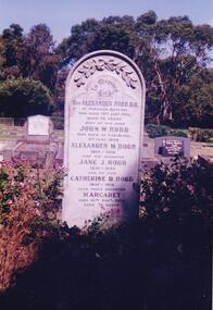
The Album was compiled by Nancy McHaffie late 1990's, with the assistance of Edith Jeffery's, with her book "Garden of Memories" and extensive knowledge of Phillip Island. The Cemetery lies back from the road and is surrounded by Manna Gums, rare Peppermint Gums, Blackwoods and other native trees. In all 25 acres of land were set aside as Crown Land in the land settlement of 1868. There are 6.2 acres of wetlands near the cemetery entrance.466-34: Captain J. B. Lock. John Barnard Lock was associated with the trading vessels to operate from Phillip Island when the settlers had most of their goods brought from Melbourne. He died in 1908 and is laid to rest in the family grave. The grave is surrounded by metal railing and flowers. 466-35: David Charles Justice. David came to the Island in 1898. He was a blacksmith, coachbuilder, farrier, agricultural engineer, wheelmaker, shipbuilder and farmer. He purchased a farm from the Harbison Estate in 1911 in the Ventnor township. He assisted Mr Will Kennon in building a punt used to recover equipment from the wreck of the "Speke". "Dinny" as he was called, married Isabella Miller (an early settlers' family). He died in November 1943 aged 79. Isabella died in October 1936 aged 86. phillip island cemetery, nancy mchaffie, edith jeffery, captain john barnard lock, david charles justice, isabella justice -
 Phillip Island and District Historical Society Inc.
Photograph Album, Kodak, Phillip Island Cemetery, c 1990
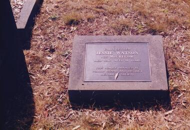
The Album was compiled by Nancy McHaffie late 1990's, with the assistance of Edith Jeffery's, with her book "Garden of Memories" and extensive knowledge of Phillip Island. The Cemetery lies back from the road and is surrounded by Manna Gums, rare Peppermint Gums, Blackwoods and other native trees. In all 25 acres of land were set aside as Crown Land in the land settlement of 1868. There are 6.2 acres of wetlands near the cemetery entrance.466-36: Jessie Watson was a daughter of the McGregor family who came to the Island in the very early days. Their selection was one of the most exposed areas on the Island. Jessie was married for a brief period and continued, with her brother Charlie, to work the family farm. Jessie was a hard worker and died in 1963 aged 98. The Plaque on her grave was donated by the Phillip island & District Historical Society. 466-37: Malcolm Sutherland. Malcolm died age 8 years while on a holiday on Phillip Island. His father was Dr. Alexander Sutherland who conducted his own school "Carlton College" Melbourne. Dr Sutherland was also appointed to the Melbourne Public Library committee for the papers taken to England by Governor La Trobe in May 1894. Malcolm was the only son of Alexander & Lizzie Sutherland.phillip island cemetery, malcolm sutherland, jessie watson nee mcgregor, nancy mchaffie, edith jeffery -
 Phillip Island and District Historical Society Inc.
Photograph Album, Kodak, Phillip Island Cemetery, c 1990
The Album was compiled by Nancy McHaffie late 1990's, with the assistance of Edith Jeffery's, with her book "Garden of Memories" and extensive knowledge of Phillip Island. The Cemetery lies back from the road and is surrounded by Manna Gums, rare Peppermint Gums, Blackwoods and other native trees. In all 25 acres of land were set aside as Crown Land in the land settlement of 1868. There are 6.2 acres of wetlands near the cemetery entrance.466-38: Rev Alexander Robb, DD. Rev Robb had been a missionary in Old Calabar and Jamaica and was the first minister of the Cowes Presbyterian Church from 1890-1901. Services were also held in the Public Hall at Rhyll. A daughter, Kathleen, like her parents, is buried in the cemetery. Kathleen was married to Harry West. 466-39: James Hill. Jimmy, as he was fondly called, came to Phillip Island in 1920 and purchased the Hotel, known as Woods Family Hotel (later the Phillip Island Hotel in Walpole Street). A milestone occurred whilst in his capable hands he installed an electric light plant, (32 volts), the first on the Island. He also made hundreds of cement bricks with which he built his own home. He died in 1937 aged 68. His only child Dorothy Edhouse aged 98, is also buried with her father.phillip island cemetery, james hill, rev alexander robb, nancy mchaffie, edith jeffery -
 Phillip Island and District Historical Society Inc.
Photograph Album, Kodak, Phillip Island Cemetery, c 1990
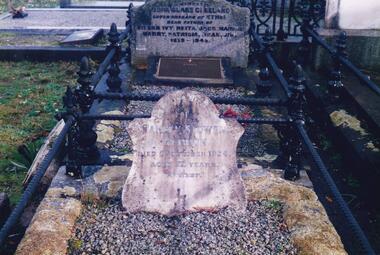
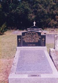
The Album was compiled by Nancy McHaffie late 1990's, with the assistance of Edith Jeffery's, with her book "Garden of Memories" and extensive knowledge of Phillip Island. The Cemetery lies back from the road and is surrounded by Manna Gums, rare Peppermint Gums, Blackwoods and other native trees. In all 25 acres of land were set aside as Crown Land in the land settlement of 1868. There are 6.2 acres of wetlands near the cemetery entrance.466-42: Thomas William Hobbs BEM. Thomas was born in England and came to the Island in the 1920's to work for the Chicory Farmers. He later owned his own farm at Ventnor and won the Better Farming Competition conducted by the Phillip Island Council. He was always an active community worker. Thomas was a Councillor and served two terms as President. He was the only resident to be awarded the British Empire Medal, Civil Division, for services to Phillip Island. Thomas died 1980 aged 75. His wife Catherine died 1991 aged 87. 466-43: Matilda Richardson. Matilda was born at Kyneton on 12th July 1865 and came to Cowes with her parents in 1869. She attended Cowes Primary School with her brothers and sisters. She became ill in November 1872 and died on 10th February 1873 aged 8 years and 7 months, from a severe bout of Quinsy. It was a great sadness to the family and they went to a lot of trouble to secure Matilda a fine grave in the cemetery. It is the oldest grave in the cemetery and a lasting memorial for her short life.phillip island cemetery, cr. hobbs, matilda richardson grave, nancy mchaffie, edith jeffery -
 Phillip Island and District Historical Society Inc.
Photograph Album, Kodak, Phillip Island Cemetery, c 1990
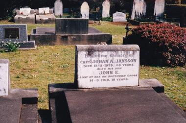
The Album was compiled by Nancy McHaffie late 1990's, with the assistance of Edith Jeffery's, with her book "Garden of Memories" and extensive knowledge of Phillip Island. The Cemetery lies back from the road and is surrounded by Manna Gums, rare Peppermint Gums, Blackwoods and other native trees. In all 25 acres of land were set aside as Crown Land in the land settlement of 1868. There are 6.2 acres of wetlands near the cemetery entrance.466-44: Captain Johan Jansson. Capatain Jansson was born in 1862 and came to Australia on the ship "Nosstaljee" in 1886. In 1887 he came to the Island and started work with Captain Lock. He bought land at Rhyll in 1891 and built a house two years later, now known as Jansson's Cottage. Johan married Evelyn Power.. a daughter of Captain Powell. He purchased the ketch "Swan" and later :Stephen" in 1914. They took chicory, seaweed, hay and other farm produce to Melbourne, returning with general cargo. Captain Jansson died in 1928 aged 66 years. 466-45: Evelyn Jansson. Evelyn was the daughter of Captain Powell. She married Johan Jansson on her 18th birthday. She died 1971 aged 95 years. Their daughter Mavis is buried with Evelyn - died 1971 aged 72 years.phillip island cemetery, johan jansson, evelyn jansson, mavis jansson, nancy mchaffie, edith jeffery -
 Phillip Island and District Historical Society Inc.
Photograph Album, Kodak, Phillip Island Cemetery, c 1990
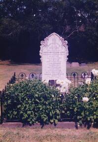
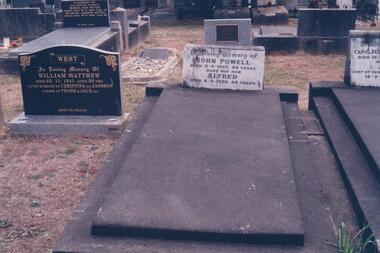
The Album was compiled by Nancy McHaffie late 1990's, with the assistance of Edith Jeffery's, with her book "Garden of Memories" and extensive knowledge of Phillip Island. The Cemetery lies back from the road and is surrounded by Manna Gums, rare Peppermint Gums, Blackwoods and other native trees. In all 25 acres of land were set aside as Crown Land in the land settlement of 1868. There are 6.2 acres of wetlands near the cemetery entrance.466-46: Captain John Powell was born in Finland in 1843. He came to Phillip Island in 1892 and resided at Rhyll with his son-in-law, Captain Johan Jansson. He died in 1927 aged 84 years. His son Alfred is also buried with him. Alfred died in 1938 aged 54 years. 466-47: Lt Colonel A. G. Cameron DSO adn BAR. Lt Colonel Cameron was the commanding officer of the 2nd Australian Infantry Batalion. He was one of only 28 Australians decorated with the DSO and BAR during WWII. He died on 8th June 1960, aged 51 years. His wife Margaret phillip island cemetery, captain john powell, alfred powell, lt colonel cameron, margaret cameron, nancy mchaffie, edith jeffery -
 Phillip Island and District Historical Society Inc.
Photograph Album, Kodak, Phillip Island Cemetery, c 1990
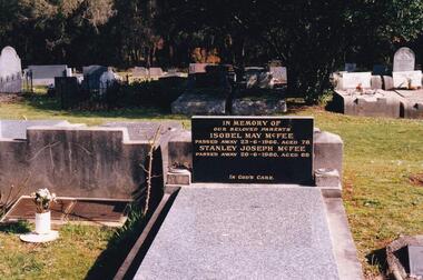
The Album was compiled by Nancy McHaffie late 1990's, with the assistance of Edith Jeffery's, with her book "Garden of Memories" and extensive knowledge of Phillip Island. The Cemetery lies back from the road and is surrounded by Manna Gums, rare Peppermint Gums, Blackwoods and other native trees. In all 25 acres of land were set aside as Crown Land in the land settlement of 1868. There are 6.2 acres of wetlands near the cemetery entrance.Stanley Joseph McFee; Stanley was born at Auburn Grove, Auburn on the 23rd January 1892. He was the seventh son of William and Annie McFee. The McFee family moved to Rhyll in 1894 where Stanley was educated at the Rhyll School. Later he took up farming at Long Point, now known as McFees Road. In 1917 Stanley married Isabell May Cherry who came to Rhyll in 1912 as the school teacher. His wife May supported him in his community activities. Stanley died 1980 aged 88. Isabell May died 1966 aged 78. phillip island cemetery, stanley mcfee, isabell mcfee, nancy mchaffie, edith jeffery -
 Phillip Island and District Historical Society Inc.
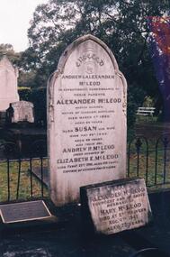
Photograph Album, Kodak, Phillip Island Cemetery, c 1889
The Album was compiled by Nancy McHaffie late 1990's, with the assistance of Edith Jeffery's, with her book "Garden of Memories" and extensive knowledge of Phillip Island. The Cemetery lies back from the road and is surrounded by Manna Gums, rare Peppermint Gums, Blackwoods and other native trees. In all 25 acres of land were set aside as Crown Land in the land settlement of 1868. There are 6.2 acres of wetlands near the cemetery entrance.Captain McLeod: Captain McLeod and family kept the Post Office at Newhaven. He also built a boat called old "Trusty" and launched it almost opposite Churchill Island. Unfortunately, at a later date, the "Trusty" was the cause of a tragedy. The bottom of the boat had become so encrusted with marine growth that the owner decided to beach her between the jetties at Griffiths point, now San Remo. Before the job was completed the soring gave way and allowed the boat to tip over on her side, causing Captain McLeod to be crushed to death. Died March 3rd 1880 aged 64 years. Also buried in this grave is his wife Susan - died May 24th 1882 aged 62 years. Their son Andrew McLeod died February 21st 1916 aged 60 - loved husband of Elizabeth E McLeod. Alexander was Captain of the "Genista" for 12 years.phillip island cemetery, captain alexander mcleod, susan mcleod, andrew mcleod, nancy mchaffie, edith jeffery -
 Phillip Island and District Historical Society Inc.
Photograph Album, Kodak, Phillip Island Cemetery, c 1990
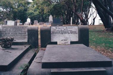
The Album was compiled by Nancy McHaffie late 1990's, with the assistance of Edith Jeffery's, with her book "Garden of Memories" and extensive knowledge of Phillip Island. The Cemetery lies back from the road and is surrounded by Manna Gums, rare Peppermint Gums, Blackwoods and other native trees. In all 25 acres of land were set aside as Crown Land in the land settlement of 1868. There are 6.2 acres of wetlands near the cemetery entrance.Two photos: a) Two graves - William Jenner & Elsie Myra Jenner. William died Oct 1957 aged 73 and Elsie died April 1968 aged 82. - William Raymond Jenner - son of William & Elsie - died Oct 1951 aged 42 years. b) Close up of William & Elsie grave. William had a farm at Ventnor, grew onions and chicory and was always willing to help out or lend any farming machinery. William was a member of the Ventnor School committee and Ventnor Hall committee. He was married to Elsie Churchill of Kilcunda and they had five children.phillip island cemetery, william jenner, elsie jenner, nancy mchaffie, edith jeffery -
 Phillip Island and District Historical Society Inc.
Photograph Album, Kodak, Phillip Island Cemetery, c 1990
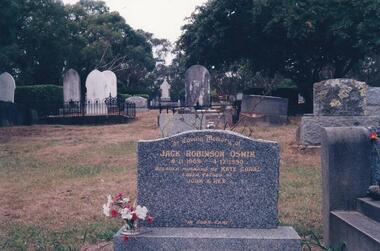
The Album was compiled by Nancy McHaffie late 1990's, with the assistance of Edith Jeffery's, with her book "Garden of Memories" and extensive knowledge of Phillip Island. The Cemetery lies back from the road and is surrounded by Manna Gums, rare Peppermint Gums, Blackwoods and other native trees. In all 25 acres of land were set aside as Crown Land in the land settlement of 1868. There are 6.2 acres of wetlands near the cemetery entrance.Jack Robinson Oswin: Many of the trees now flourishing in the cemetery grounds were planted by Jack Oswin and his wife Coral. Born in Mildura in 1909, his association with Phillip Island started when he attended the Cowes Primary School during the war years. He was foundation member of the Phillip Island Conservation Society and played a key role in the purchases of the area of land known as Conservation Hill. In the early 1980s he was awarded the British Empire Medal in recognition for his services to conservation. Jack died on December 4th 1990, aged 81 years.phillip island cemetery, jack robinson oswin, coral oswin, nancy mchaffie, edith jeffery -
 Phillip Island and District Historical Society Inc.
Photograph Album, Kodak, Phillip Island Cemetery, c 1990
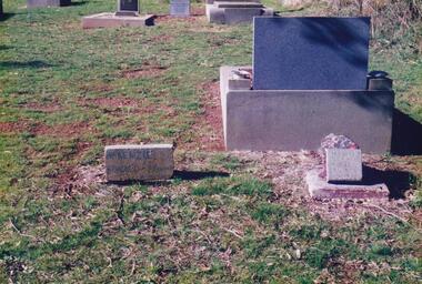
The Album was compiled by Nancy McHaffie late 1990's, with the assistance of Edith Jeffery's, with her book "Garden of Memories" and extensive knowledge of Phillip Island. The Cemetery lies back from the road and is surrounded by Manna Gums, rare Peppermint Gums, Blackwoods and other native trees. In all 25 acres of land were set aside as Crown Land in the land settlement of 1868. There are 6.2 acres of wetlands near the cemetery entrance.The McKenzie Children: Late one night in 1934, Mr Bryant West and Mr Loton heard cries for help from the vicinity of the Cowes Jetty. Attempts were made to save a woman and the children. Sadly only the adult could be rescued. The three young bodies were later recovered and buried in the cemetery. Parents: Ronald & Ena McKenzie - Children: Ronald aged 5 years, Ena Roma aged 4 years and Douglas Forbes aged 1 year. phillip island cemetery, the mckenzie children, nancy mchaffie, edith jeffery -
 Phillip Island and District Historical Society Inc.
Photograph Album, Kodak, Phillip Island Cemetery, c 1990
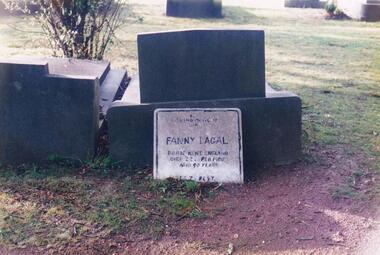
The Album was compiled by Nancy McHaffie late 1990's, with the assistance of Edith Jeffery's, with her book "Garden of Memories" and extensive knowledge of Phillip Island. The Cemetery lies back from the road and is surrounded by Manna Gums, rare Peppermint Gums, Blackwoods and other native trees. In all 25 acres of land were set aside as Crown Land in the land settlement of 1868. There are 6.2 acres of wetlands near the cemetery entrance.FANNY LAGAL (nee THOMPSON): Fanny arrived in Australia in the early 1920s. After her husband died she arrived on Phillip Island. She worked at "Summerland House" and later at the "Isle of Wight Hotel". She took great pride in keeping the altar linen and generally looking after the Anglican Church. Those who knew her said she was a gracious lady with a great sense of humour. Fanny went to a nursing home at Frankston where she resided until she died in February 1980, aged 90. Friends arranged for her to be buried at the Cemetery.phillip island cemetery, fanny lagal nee thompson, nancy mchaffie, edith jeffery -
 Phillip Island and District Historical Society Inc.
Photograph Album, Kodak, Phillip Island Cemetery, c 1990
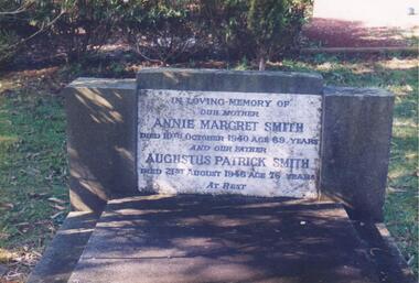
The Album was compiled by Nancy McHaffie late 1990's, with the assistance of Edith Jeffery's, with her book "Garden of Memories" and extensive knowledge of Phillip Island. The Cemetery lies back from the road and is surrounded by Manna Gums, rare Peppermint Gums, Blackwoods and other native trees. In all 25 acres of land were set aside as Crown Land in the land settlement of 1868. There are 6.2 acres of wetlands near the cemetery entrance.466-54: Annie Margaret Smith (nee Kearns) and Augustus Patrick Smith. Annie died in 1940 aged 69 years and was the wife of Augustus who died 1946 aged 76 years. He was the son of George Smith who arrived on Phillip Island about 1869. He paid 20 shillings per acre for 175 acres. 466-55: Margaret Jean Mallory. Margaret arrived on the Island in 1929 to teach at the Ventnor School. She became interested in community affairs and was the first to start the Girl Guides. She was President of the CWA and foundation member of the Golf Club. Margaret with her husband William (Bill), were tireless workers for the Children's Hospital along with many other worthy causes. Margaret died on November 25th, 1982 aged 75. William died February 1989 aged 87.phillip island cemetery, annie margaret smith nee kearns, augustus patrick smith, george smith, margaret jean mallory, william alfred mallory, nancy mchaffie, edith jeffery -
 Eltham District Historical Society Inc
Photograph, Joh Ebeli, Point Nepean Gun Turret, Portsea and Sorrento, 1 December 1985, 01/12/1985
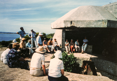
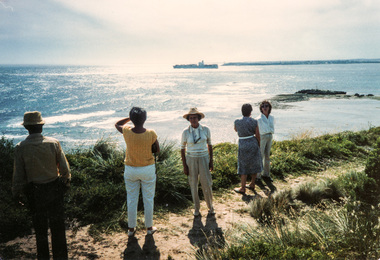
[from EDHS Newsletter No. 46, January 1986:] Our bus trip to Portsea was considered by many to be one of the most enjoyable staged by the Society. Peter Collins of the Peninsula Historical Society travelled with us as a guide. He proved most informative and entertaining, particularly with regard to the Army and Quarantine Reserve at Point Nepean. We also visited the Museum at Sorrento and the site of the 1803 First Settlement. This was a long and tiring, but very rewarding, trip.Colour photographactivities, portsea, sorrento -
 Eltham District Historical Society Inc
Photograph, Joh Ebeli, Ship passing the Rip, Portsea and Sorrento, 1 December 1985, 01/12/1985
[from EDHS Newsletter No. 46, January 1986:] Our bus trip to Portsea was considered by many to be one of the most enjoyable staged by the Society. Peter Collins of the Peninsula Historical Society travelled with us as a guide. He proved most informative and entertaining, particularly with regard to the Army and Quarantine Reserve at Point Nepean. We also visited the Museum at Sorrento and the site of the 1803 First Settlement. This was a long and tiring, but very rewarding, trip.Colour photographactivities, portsea, sorrento -
 Warrnambool and District Historical Society Inc.
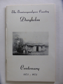
Booklet, The Temiangandeen Country Dergholm, 1973
This booklet gives information on the settlement of Dergholm at the time of the centenary of its founding, 1973. The origin of the name Dergholm is unclear but it may have Irish connections. Europeans came to the area in the 1840s and 50s but it was not until the 1870s that the town was surveyed. Dergholm is in the far west of Victoria 334 kilometres from Melbourne and nearby is Dergholm State Park established in 1982. The booklet was produced for the Centenary Back to Dergholm Committee and the local centenary celebrations. This book is of some interest as it provides information on Dergholm, a settlement in the far west of Western Victoria. This is a soft cover booklet of 52 pages by Alistair Roper. It has a cream-coloured cover with a black and white photograph of early Dergholm on the front cover (Edward Quinn’s house). The booklet has printed material - a President’s Message, an Author’s Note, Acknowledgements, Contents, information on the Dergholm area, including a list of local birds, and References. There are several black and white photographs of the area and its people. The book is stapled. Front Cover: ‘The Temiangandgeen Country, Dergholm Centenary, 1873-1973’dergholm victoria, alistair roper, history of western district of victoria -
 Marysville & District Historical Society
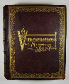
Book - Hardcover book, Alexander Sutherland, M.A, Victoria and its Metropolis-Past and Present-Volume 1, 1888
A history of Victoria from the time of the discovery of Australia through until 1888.Hardback. Dark brown cover with the title in gold lettering. There is also a border in gold decorating the outer edge of the front cover. The spine is also decorated in gold along with the title and the volume number.non-fictionA history of Victoria from the time of the discovery of Australia through until 1888.melbourne, victoria, exploration, settlement, john batman, john pascoe fawkner, pioneers, colonisation, immegration, aboriginals, discovery of gold, democracy, burke and wills, agriculture, manufacturing, literature, art, music, drama, education, science, churches, history -
 National Wool Museum
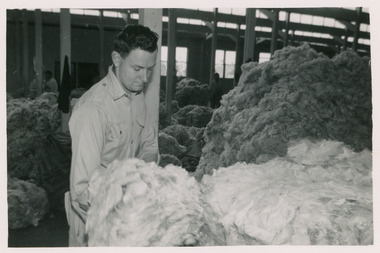
Photograph - Denny Lecelles Photographs, c1950
Father of the donor, Mervyn Graham, worked for Denny Lascelles for many years as a wool classer in Geelong and later as a representative in Hamilton. The Denny Lascelles Wool Warehouse was the first building in Victorian planned to facilitate storage, inspection and marketing of wool in one operation, and upon completion was the second largest store in the colony. CJ Denny's was largely responsible for establishment and development of the wool marketing industry in Geelong and is a figure of significance in the history of settlement in Geelong.Black and white photos showcase different rooms of the Denny Lascelles building and the process of classing the wool within the store, from classing the wool to packaging and transportation.8080.7 - On wool press - Made by Johns & Waygood LTD. Melbourne Australia 8080.10 - On truck - Blackiston & Co PTY. LTD. Road transporters. Geelong & Melb.denny lascelles, geelong, wool, wool class, transportation -
 Phillip Island and District Historical Society Inc.
Photograph Album, Kodak, Phillip Island Cemetery, c 1990
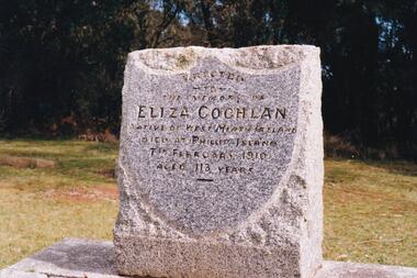
The Album was compiled by Nancy McHaffie late 1990's, with the assistance of Edith Jeffery's, with her book "Garden of Memories" and extensive knowledge of Phillip Island. The Cemetery lies back from the road and is surrounded by Manna Gums, rare Peppermint Gums, Blackwoods and other native trees. In all 25 acres of land were set aside as Crown Land in the land settlement of 1868. There are 6.2 acres of wetlands near the cemetery entrance.a) Grave stone of Eliza Coghlan b) Grave stone of Eliza Coghlan with Edith Jeffery standing beside. Eliza was born in West Heath, Ireland. She arrived in Australia on the immigrant ship "Thomas Arbuthnot". She came to Phillip Island as house-keeper to James Duffus and served for 40 years. She was often seen walking to Cowes, about five miles, carrying a heavy turkey. The main road to the cemetery was named in her honour. It has been claimed that Eliza with the oldest subject of Queen Victoria. She died in February 1910, at the age of 113.phillip island cemetery, nancy mchaffie, edith jeffery -
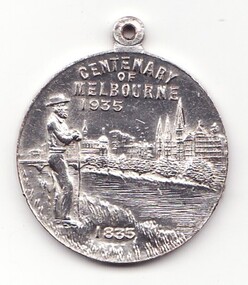 Learmonth and District Historical Society Inc.
Medal - Centenary of Victoria, Centenary of Melbourne 1935
White metal medal issued to commemorate Melbourne's centenary 1934-35. This medal was given out to Victorian school children; 325,600 white metal medals were struck. There were also a few VIP pieces in other metals, including two in gold. The medal references Portland, the location of Victoria's first settlement. The Henty brothers, entrepreneur farmers and whalers, established the state's first permanent European settlement in Portland in 1834. Melbourne was established the following year by a party of settlers led by John Batman. In 1934, as Melbourne planned to celebrate the centenary of European settlement, it seemed to some that there was little to celebrate. The financial strains of the depression, unemployment and the scandal of the city's slums all undercut claims of unbridled progress. Perhaps because of such troubles, the organisers of the centenary celebrations tried doubly hard to be positive. The themes of the celebrations were conservative, reflecting the desire of some Melburnians for security in troubled times. The widely promoted image of the 'Garden City' and 'Queen City of the South' emphasised the idea of Melbourne as a very British city. A visit by the Duke of Gloucester, son of George V, the ageing king, provided a reassuring strengthening of Melbourne's imperial connections. The presented view of Melbourne's history stressed the 'myth of the pioneer', embodied in the person of John Batman. Elevated to heroic status, he was reinvented as a courageous pioneer whose life exemplified the rewards of self-improvement. Such a portrayal ignored Batman's dubious 'treaty' with local Aborigines and the less savoury details of his personal life. Melbourne's indigenous people were excluded from this triumphant view of Melbourne's past. The centenary celebrations now seem dated, but the image of Melbourne as a conservative city largely influenced by Britain has been more enduring.Details the settlement of Portland, Melbourne and Victoria, 1834 - 1935Double sided round white metal medal, featuring on front face, the bay of Portland showing a ship in the harbour. On the reverse side of the medal is John Bateman overlooking the city of Melbourne and the Yarra river.The front is inscribed, "CENTENARY OF VICTORIA" 1934, across the top, bottom right has the words "PORTLAND 1834". Reverse side shows "CENTENARY OF MELBOURNE 1935", and the date 1835 at the bottom. melbourne, medal, portland, centenary of victoria 1935 -
 Ballarat Heritage Services
Photograph - Photograph - Colour, Former Lake Condah Aboriginal Mission, 17/04/2016
The Lake Condah Mission site includes bluestone ruins and a reconstructed timber building, as well as the cemetery which were part of the original settlement. With European settlement in the 1830s came conflict. Gunditjmara people fought for their land during the Eumerella wars, which lasted more than 20 years. As this conflict drew to an end in the 1860s, many Aboriginal people were displaced and the Victorian government began to develop reserves to house them. Many Aboriginal people refused to move from their ancestral land and eventually the government agreed to build a mission at Lake Condah, close to some of the eel traps and within sight of Budj Bim (Mt Eccles). The mission opened in 1867. The Mission was formally closed in 1918, and Aboriginal people were forced off the Mission, some moving to Lake Tyers. The Gunditjmara protested against the Mission’s closure and many continued to reside in the buildings until the majority of the reserve land was handed over to the Soldier Settlement Scheme in the 1940s. The mission was destroyed by the government in the 1950s in an effort to force the integration of Gunditjmara people with the general community but the Gunditjmara people continued to live in the area and protect their heritage. The mission lands were returned to the Gunditjmara in 1987. Lake Condah Mission is a place with special meaning to the Gunditjmara community - as a community meeting place, an administrative centre, a symbol of political struggle and a link to family histories. As a result the Gunditjmara community do not want open public access to this site. Key Features of Interest Ruins of stone cottages and plot remains of buildings such as the church Reconstructed dormitory building (https://www.budjbim.com.au/visit/cultural-sites/lake-condah-mission/?gclid=EAIaIQobChMIz6j36ZvF-QIV8ZhmAh2tmA3qEAAYASAAEgLxrvD_BwE, accessed 2022)Colour photographs of the former Lake Condah Aboriginal Missionlake condah, lake condah aboriginal mission, aborigines, aboriginal, gunditjmara, eumerella wars -
 Phillip Island and District Historical Society Inc.
Photographs, James Findlay, 1920 to 1923
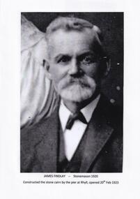
Photographs relating to the Rhyll Cairn constructed by James Findlay. Unveiling by The Earl of Stradbroke on 20th February 1923. Built to commemorate the discovery of Westernport by George Bass 4th January, 1798. Visits followed by Lieut James Grant March 1801, Lieut John Murray December 1801. The French under Capt. Baudin April, 1802 and Capt D'Urville November 1826. Also the establishment of a temporary British settlement (For Dumaresq) December 1826.453-01: Black & White Photograph of James Findlay - Stonemason 1920. Constructed the Stone Cairn by the pier at Rhyll. 453-02: Photograph of James Findlay constructing the Rhyll Cairn 1922 together with a copy of the Inscription on the Plaque. 453-03: Photograph of the Stone Cairn at Rhyll being unveiled by The Earl of Stradbroke on 20th February 1923.rhyll cairn, james findlay, bill cooper -
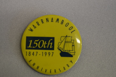 Warrnambool and District Historical Society Inc.
Badge, Warrnambool 150th 1847-1997
This badge was produced in 1997 as a souvenir of the 150th anniversary of the founding of Warrnambool. Warrnambool was a planned town, established in 1847 as a port to service the squatters who had taken up large tracts of land in the Warrnambool area in the 1840s.The town was surveyed by the Government surveyor William Pickering at the request of Superintendent La Trobe and the first town lots of the new town were sold in Melbourne in 1847, with some settlers arriving at the new settlement soon after.This badge is one of the many souvenirs of the 1997 celebrations in Warrnambool Circular concave metal badge with blue drawing of a sailing ship and text. There is a clip pin on the reverse.WARRNAMBOOL ANNIVERSARY 150th 1847 -1997 -
 Mt Dandenong & District Historical Society Inc.
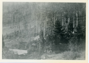
Photograph, View Over Roof of "Kalorama"
Taken in 1908, this photograph, though rather blurry, gives an indication of the location of the early settler properties in the valley in relation to one another. European trees have been planted at 'Kalorama' , the first home of Ellis Jeeves. John Lundy-Clarke grew up in the Kalorama/Mt Dandenong area and later in life (1972-74) began to write a comprehensive history of the area working from an original settlement map in an effort to cover all areas.Black and white photograph looking across hillside with large trees and rooftops visible. Handwritten description on reverse by John Lundy-Clarke.1908 View over roof of “Kalorama” towards the Falls. Paynter’s house on LOT 29 in low centre (now “Yosemite”). Pimms house on LOT 19 above Paynters and beyond scrub. Logan’s house faint above left of “Kalorama”. Dunbar’s LOT 20 beyond Pimm’s orchard. Gum trees on right were on Price’s LOT 19 now Tosari Rd area. It was one of these that figured in the episode of the runaway log in 1930. It leaped in one bound over Barbers Road at bottom of scrub in centre of picture then over Logan’s house.kalorama, ellis jeeves, jeeves -
 Mt Dandenong & District Historical Society Inc.
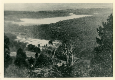
Photograph, Harmony Vale 1933
John Lundy-Clarke grew up in the Kalorama/Mt Dandenong area and later in life (1972-74) began to write a comprehensive history of the area working from an original settlement map in an effort to cover all areas. Harmony Vale was the name of the homestead built by early pioneer Jabez Richardson. The whole of the valley took on this name. The building lasted until 1933. The Silvan Dam was completed in 1932 and was full when this photograph was taken.Black and white photograph looking down over a forested area with a dam in the background. Copied from a Rose Series postcard c1933. Handwritten inscription on reverse by John Lundy-ClarkeRose Series photo of 1933 showing “Harmony Vale” still standing. Copied 1973 JLCharmony vale, silvan dam, jabez richardson -
 Mt Dandenong & District Historical Society Inc.
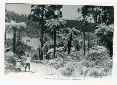
Photograph, View From Doughty's Road 1913
Mt Calvin, the homestead of Jeanie and Willie Richardson can be clearly seen in the clearing above the men in the picture. The white roof of the Barber homestead is on the right of the picture. A landslide in 1934 destroyed the tree ferned area. John Lundy-Clarke grew up in the Kalorama/Mt Dandenong area and later in life (1972-74) began to write a comprehensive history of the area working from an original settlement map in an effort to cover all areas.Black and white photograph that is a copy of a Rose series postcard titled 'The Picturesque Road to Mt. Dandenong. Vic.' It shows two men (probably Rose Series employees), one sitting and one standing at the edge of an unmade road. Large tree ferns line the roadside. Handwritten inscription on reverse by John Lundy-Clarke1913 View east from Doughty’s Road showing Jeannie Richardson’s home through the gap in the trees. A little to the right of and below centre of picture can be seen George Barber’s home with Barbers Road turning around the wagon shed that was a little up the hill from the house. The tree ferns in the picture were destroyed in the landslide of 1934. In the distance at the right can be seen F.M. Childs Homestead complex with the Richardson paddocks beyond it.mt calvin, jeanie richardson, willie richardson, george barber, landslide, tree fern -
 Mt Dandenong & District Historical Society Inc.
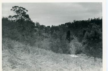
Photograph, View Up Valley Towards Kalorama Gap 1973
John Lundy-Clarke grew up in the Kalorama/Mt Dandenong area and later in life (1972-74) began to write a comprehensive history of the area working from an original settlement map in an effort to cover all areas. This photograph would have been taken to show the changes in the area over the years. Kalorama Gap is now called Five Ways. 'Kia-Ora ' was a guest house built by George Barber. It is no longer standing.Black and white photograph showing a bush scene with a white car visible on the right. Handwritten inscription on reverse by John Lundy-Clarke1973 View up Valley towards Kalorama Gap from what was Crooks LOT 24. White car is on Barbers Road and site of “Kia Ora” is to right of it.kalorama, kalorama gap, five ways, barbers road, george barber, kia-ora -
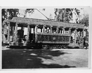 Ballarat Tramway Museum
Photograph - B&W print of donated negative and Digital Image of decorated tram 23, State Electricity Commission of Victoria (SECV), 1938
Ballarat No. 23 was decorated with waxed paper flowers for the centenary of settlement in the Ballarat district in 1938. Tram has female students on board, with a conductor alighting. Shows track brakes on the tramcar. A floral tram. See also Reg Items 1021, 1362 and 3813 for other photographs of this tram, in particular 3813 which is a colour rendition of this photograph. See page 70 & 71 of "The Golden City and its Tramways" for these photographs and others in use and notes.Yields information about Ballarat 's 23, ex Adelaide No. 69 when decorated for the 1938 state celebrations, school children on the tram and conductorsBlack and white photo prints from a collected negative. tramways, trams, centenary, decorated trams, special trams, floral tram, tram 23, tram 69 -
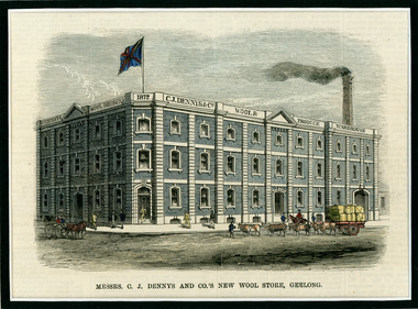 National Wool Museum
Newspaper Cutting, Messrs. C. J. Dennys and Co.'s New Wool Store Geelong, 10/9/1872
The Denny Lascelles Wool Warehouse was the first building in Victorian planned to facilitate storage, inspection and marketing of wool in one operation, and upon completion was the second largest store in the colony. CJ Denny's was largely responsible for establishment and development of the wool marketing industry in Geelong and is a figure of significance in the history of settlement in Geelong. The wool store, a basalt structure with cement rendered ornamentation, was erected for CJ Denny's and Co, in 1872 to the design of Jacob Pitman, Architect.Wood cut engraving of the Mesrs. C. J. Dennys and Co.'s New Wool Store Geelong, published in The Illustrated Australian News, 1872. The half page full colour illustration shows the newly constructed Wool Store with a bull drawn cart carrying full wool bales situated out the front of the store.Top margin: THE ILLUSTRATED AUSTRALIAN NEWS 201 Below image: Mesrs. C. J. Dennys and Co.'s New Wool Store Geelong Image signed, lower mid edge: WINSTON Image, on building: C.J. Dennys Wool Brokers 1872 C.J. Dennys & Co. Wool & Produce Warehousedenny lascelles wool warehouse, wool, dennys, wool store