Showing 110319 items matching "roads"
-
 Mt Dandenong & District Historical Society Inc.
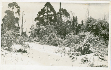
Photograph, Snowfall At Chalet Road, 1921
Postcard made for E. Woorich "Range View" Olinda showing Chalet Road in Olinda under snow in 1921.Printed on back in purple ink: E. Woorich "Range View" Olinda Handwritten in pen: 1921 snowfall at Chalet Road.range view nursery, e. woolrich, chalet road, snow, olinda -
 Eltham District Historical Society Inc
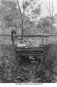
Photograph, The Rose Stereograph Company, Log Bridge, Eltham Road. Greensborough, c.1920
A woman stands at the end of a log bridge over a creek looking towards the south along the unsealed roadway. The sun illuminates her back. She is wearing a woollen knit beanie with edges rolled up, dark jacket and skirt, full length dark stockings and slip on dark leather shoes with raised heel, typical of the early 1920s. The creek is possibly feeding into the Karingal Yalloc. The direction of the road based on shadows is northwest as is the Eltham Road to Greensborough (present day Sherbourne, Karingal and St Helena roads). The creek is falling to the foreground so from south west to the north east, possibly feeding into the Karingal Yalloc, somewhere near presenet day Ramptons Road Reserve. This glass plate negative was used to manufacture postcards (1:1 printing) for commercial sale by the Rose Sterograph Company and its subsidiaries. George Rose founded the Rose Stereograph Company in 1880 and was joined by Herbert (Bert) Cutts in the early 20th Century. The pair formed a lifetime working partnership and strong personal friendship. Assisted by George’s two sons, Herbert George and Walter, and later by Neil Cutts, the Rose Stereograph Company continued its operations for more than 140 years. The company was initially built on stereographs, but as cinema took over and stereographs fell out of fashion, the Rose Stereograph Company developed Australia’s first commercially viable photographic postcard business. Specialising in postcards of iconic historical moments and significant landmarks, The Rose Stereograph Company became a staple of the Australian travel industry.This remarkable collection of glass plate negatives, transparencies, and postcards – arguably Australia’s most significant photography collection outside of public hands – has been passed down through the generations, surviving war, relocation, and the harsh Victorian climate. The historic Rose Stereograph collection is the culmination of George Rose’s dream of capturing and preserving precious moments in time and remains the legacy of the Rose and Cutts families. It is with great sadness that the Cutts family says goodbye to a collection that spans five generations and 140 years. The Cutts family understands that for these historically important pieces to rest with one family is to deny others the pleasure of their custodianship.Glass Plate Negative Size: 9.2 x 13.8 cmLog Bridge, Eltham Road, Greensborougheltham, postcard, travel, rose stereograph company, glass plate negative, creek, eltham road, greensborough, karingal road, karingal yallock, log bridge, sherbourne road, st helena road, women's fashion, rampton's road reserve, peter and elizabeth pidgeon collection -
 Warrnambool and District Historical Society Inc.
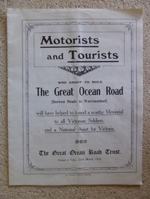
Leaflet, Motorists and Tourists
This leaflet published by The Great Ocean Road Trust in 1918 gives information about the proposed building of the Great Ocean Road from Barwon Heads to Warrnambool as a memorial to Victorian soldiers in World War One. The President of the Trust, which was a private company seeking donations from the public, was Howard Hitchcock, the Mayor of Geelong. The Memorial Great Ocean Road commenced in 1919 with 3000 ex-servicemen employed to build the road. In 1932 the road was completed to Apollo Bay and in 1936 the road was officially handed into the care of the State Government. This leaflet is of some significance as it shows the initial efforts by Howard Hitchcock of Geelong and a private trust to build the Great Ocean Road in Victoria. This road is today of international significance This is an unbound leaflet of 8 pages (almost A4 size) folded into two insert pages. It has 10 photographs of views along the Great Ocean Road and typed information on the Great Ocean Road Trust and its Building Appeal. It was produced in 1918.great ocean road, great ocean road trust 1918, warrnambool history, memorial great ocean road -
 City of Moorabbin Historical Society (Operating the Box Cottage Museum)
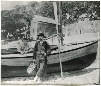
Photograph, 2 B&W, 1898 The O'Maras', Sandringham Fishermen : Date Unknown, Mud Brick House, 1898 The O'Maras', Sandringham Fishermen Date Unknown, Mud Brick House, 1898
The O'Maras, of Sandringham fishermen. Early mud brick house. Located in Moorabbin and was still there in 1940. The house was situated in Reserve Road, almost opposite Wangara Road, (formerly Cemetery Road). About twelve years ago, (* the writer states no year), there was a vacant block where the house used to be - it was next to a electrical factory. 2x Black and White Photographs. (i) An 1898 photograph showing two men with a fishing boat on the beach. A beach house / shed , paling fence and tall tea-trees are seen in the background. (ii) A large early mud brick house with a tin roof, chimney and a water tank sitting on a block of grassed landWritten on back (i) The O'Maras / Sandringham / fishermen 1898 (ii) Mud brick house at Moorabbin ( house was there in 1940) / Situated in Reserve Road almost opposite Wangara Road / ( formerly Cemetery Road ). About 12 years ago there was a vacant block where the house used to be and it was next to an electrical factory. unsigned undatedthe o'maras, sandringham fisherman, 1898, mud brick house, moorabbin, wangara road, reserve road, electrical factory, early settlers, pioneers, shire of moorabbin, sandringham, beaumaris, mentone, fishermen, dairy farmaers, poultry farmers, market gardeners, -
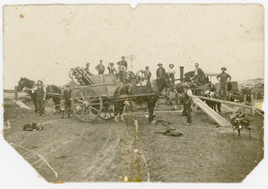
 Kiewa Valley Historical Society
Black and White photograph of Road Making Machinery, Kiewa Road Making, 25/08/1938
Construction of the main road from South Tawonga to the Bogong High Plains, to provide access to the construction sites for the new Kiewa Hydro Electric Scheme, was commenced early in 1938, the work being undertaken on behalf of the Commission by the Country Roads Board. For the construction work, the Commission purchased three Caterpillar - model R07 - diesel crawler tractors equipped with Kay Brunerei (Brunner) hydraulically operated trailbuilders (angle dozers). This acquisition resulted from a visit to the United States of America in May, 1937 by the Construction Engineer ( Mr. C.H. Kernot) and Assistant Civil Engineer (Mr. J.F. Douglas) where they saw this relatively new type of equipment in use. With the co-operation of the CRB, the Commission demonstrated the operation of these machines at Fishermen's Bend on 6th April, 1938. They were then sent to Kiewa where they commenced operation towards the end of the month. From South Tawonga, the route led immediately across the Western Branch of the Kiewa River necessitating the construction of a bridge 100 feet long. By the end of 1939, the excavation had been 'opened up' for a distance of 19 1/2 miles (approx. 31 km) and of this length, 10 miles (approx. 16 km) had been surfaced.The purchase and use of this type of mechanical equipment in road making was a huge investment, as prior to this most of the work would have been done manually with the use of picks and shovels. Not only were many months of hard manual labour saved, but a very significant amount of time in providing access to the proposed work sites for the new Kiewa Hydro Scheme. This photo is an excellent reminder of how primitive the early machinery was compared to the present but also represents the forward thinking of the State Electricity Commissions engineers in purchasing such innovative equipment . A black and white photograph showing the type of machinery used for road making in the 1930's. It shows a grader being towed by a caterpillar tractor.On the top left hand corner of the photograph , hand written in black ink is the words 'Kiewa Road Making 25/8/1938'. On the right hand side of the photo has been stamped in blue the Number 1. It has been developed on Velox paper (marked on back of photo) with a gloss finish.road making, state electricity commission, caterpillar tractor, kiewa -
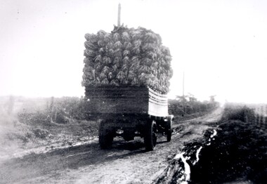 City of Kingston
Photograph - Black and white
A truck, fully loaded with cauliflower travelling along McKinnon Road towards Tucker Road. The road is unsealed and recent rains have left large puddles along the sides. Open paddocks appear on either side of the road.Black and white image of a truck fully loaded with cauliflowers travelling along an unsealed boggy road, to market.Black ink printed on a white circular sticker: 32 Handwritten in red ink: 70%vegetables, cauliflower, market, truck, transport -
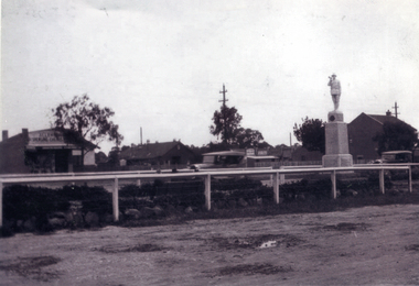 Whitehorse Historical Society Inc.
Photograph, Mitcham War Memorial
The Mitcham War Memorial is now located in Halliday Park.in Mitcham Road.Black & white photo of the Mitcham War Memorial in the centre plantation west of Mitcham Road & Whitehorse road intersection. Allan's Butcher shop is on the left and the Post Office on the right.war memorial mitcham, war memorials -
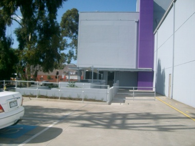 Vision Australia
Photograph - Image, Interior and exterior view of Vision Australia's office at 346 Macaulay Road, Kensington, April 2008
Interior and exterior view of Vision Australia's office at 346 Macaulay Road, Kensington.11 digital photographs of VA Macaulay Road Officevision australia, macaulay road kensington -
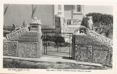 Phillip Island and District Historical Society Inc.
Photograph - Post Cards, Rose Series, c 1970
Three Postcards donated by Alan Clark from the Shoalhaven Historical Society.Three Black & White Postcards of The Shell House fence and gate, Nobbies Road, Summerland, Phillip Island.237-01. The Rose Series P 4026. The Shell Fence, Nobbies Road, Phillip island. Signatures on back: A N Robertson & N P Moloney 237-02. The Rose Series P 4028. The Shell Fence, Nobbies Road, Phillip island. Signatures on back: A N Robertson & N P Moloney 237-03. The Rose Series P 4025. The Shell Fence, Nobbies Road, Phillip island. Signatures on back: A N Robertson & N P Moloneyshell house phillip island, the shell fence summerland phillip island, the shell house phillip island, a clark, shoalhaven historical society -
 Clunes Museum
Photograph
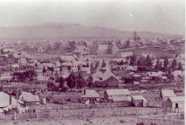
BLACK AND WHITE PHOTOGRAPH OF CLUNES TOWNSHIP, TAKEN FROM LESLIE STREET EAST, OFF SMEATON ROAD.METHODIST & PRESBYTERIAN CHURCHES IN CENTRE TAKEN FROM LESLIE ST. EAST OF SMEATON ROAD NOTE WESLEYAN CHURCH HAS SPIRElocal history, photography, photographs, clunes township -
 University of Melbourne, Burnley Campus Archives
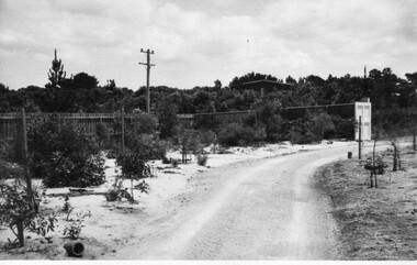
Photograph - Black and white print, Glen Wilson, Australian Native Plants Under Mulch, Unknown
Note by E.B. Littlejohn 11 December 1991, "Glen Wilson submitted these photographs of his work using sawdust mulch, whilst attending Evening Classes."Black and white photograph with an envelope. View of an unmade road or drive with plants on each side surrounded by mulch.Envelope with caption, "Australian native plants under mulch ex Glen Wilson 334 Springvale Road Springvale 746-8824."native plants, glen wilson, sawdust mulch, evening classes -
 Eltham District Historical Society Inc
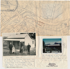
Folder, Colemans Corner, Eltham
Letter from Nillumbik Council to H.Gilham in response to consultation on Wattletree Road Bridge replacement, 13 August 2007, 1p. VicRoads brochure on Wattletree Road bridge replacement project, August 2007, 1p Photo of "Coleman's house", 1904 with brief family history. (Photo retrieved by Harry Gilham from from a 1972 'time capsule bucket' found at the Eltham Shire Office during its demolition in July-August 1996 (See also SEPP_0745 and 1678A) Photo of "Coleman's house", 1971 Survey plan showing location of Coleman's houseFolder of information and photos relating to the Colemans Corner precinct located on the corner of Main Road and Wattletree Road, Eltham. HG Booklet 9bus services, wattletree road bridge, coleman family, coleman's corner, harry gilham collection -
 Halls Gap & Grampians Historical Society
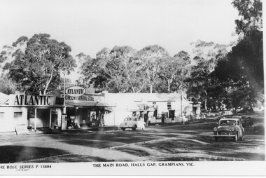
Postcard - B/W, C 1950s
Thomson's and Taylor's shops with the Halls Gap Hall further along the road. A number of 1950's vintage cars are parked along the main road. No. 13884 in the Rose Series of postcards.A strip of shops along a bitumen road. One shop is a garage with Atlantic signs and another has a sign that reads "Thomson's General Store". There are several cars parked along the road and eucalyptus trees in the background.buildings, shops -
 National Wool Museum
Photograph
Donor purchased this photograph from an op. shop. It depicts workman surfacing a road in the Geelong area. The steam engine present is driving a belt to operate a crusher which is crushing rock to surface the road. The drays are used to carry the crushed rock.Photograph, road surfacing in the Geelong area, c.1900-20.road surfacing -
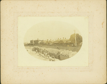 Kew Historical Society Inc
Photograph - Regrading the Camberwell Railway Line near Burke Road, E.J. Dower, 1915
One of a series of photographs, taken by Edgar James Dower in the second decade of the twentieth century. Born and raised in Olinda, his family later moved to Surrey Hills. He worked as an adult as a clerk in the city office of the Metropolitan Gas Company, and in his role as a 'collector', he was able to photograph scenes including the construction of tramlines, railways and associated buildings in Kew, Hawthorn, Camberwell and Surrey Hills. Later he established a real estate agency with his brother - the E.J. Dower Real Estate Agency, Dandenong Office.The image is an historically significant record of the development of transport infrastructure which was used to connect Victorians in the first two decades of the twentieth century. This development resulted from increases in population and the consequent extension of Melbourne's suburbs. The photographs, both individually and collectively, richly detail the labour of workers and the tools and machinery used to create and extend Melbourne's public transport network in the years preceding and during World War 1.Digital copy of an original oval mounted photograph depicting workers regrading the Camberwell Railway line in the vicinity of Burke Road following the demolition of the original Camberwell Railway Station. Verso: "1915 / Regrading Camberwell railway line, near Burke Road / Taken by E.J.Dower."theme -- connecting victorians by transport and communications, theme - camberwell railway station, theme - travelling by train -
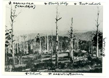 Mt Dandenong & District Historical Society Inc.
Photograph
Iconic photograph taken by Edgar Dower on Ridge Road in 1913 from an area known as Point Clear that shows the buildings of early Mt Dandenong before the CRB road went through in the 1920s.Black and white photograph with tall, dead trees in foreground and a view of hills in the distance. Buildings can be seen across the centre of the photograph. There are handwritten annotations around the border with arrows referring to areas in the photograph. Reverse of photograph has handwritten description by John Lundy-Clarke.Front from top left: Namoora (Lumeah), Dower's Shop, First school, Talent's, Langford's house, School. Reverse: 1913 view from O'Halloran's LOT 4, Section 3 on Ridge Road. Showing Lumeah (Namoora) Farndons Road (fence) School, Lowes House?, Falls Road Shop (Dowers) Langford's Falls Road (LOT 9, Section 1) Shed on Colomb's LOT 19, Sect 2 Colomb's House (Fergusons) First school Campbell's Blythes Road Lil Badenhop's P.O. In middle distance - Talent's homestead and sheds.point clear, namoora, lumeah, langford, dower, talent, colomb, ferguson, campbell, farndons road, mt dandenong school -
 City of Kingston
Pamphlet - Colour, Roy Dunn Pty. Ltd, Central Corner Estate Moorabbin and Highett, c. 1923
Sales plan for land in the suburbs of Highett and Moorabbin, bordered by Point Nepean Road and Wickham Road East incorporating William StreetThe developing urban area of Highett and Moorabbin within the City of Kingston. This land sale pamphlet illustrates the subdivision of land within the municipality and the changing demographic of the district as new houses are constructed close to infrastructure.Colour pamphlet advertising for private sale land in the Central Corner Estate in Moorabbin and Highett. Incorporates a map of the estate bordered by Point Nepean Road and Wickham Road East, with subdivisions also available on both sides of William Street. Handwritten in blue pencil on subdivision plan: a tick is drawn on subdivisions 2-18 Handwritten in blue pencil on subdivision 6: a box with an x inside Handwritten in blue pencil on subdivisions 10 and 12: S Handwritten in black ink on front page: [indecipherable] / McKittricks Handwritten in grey pencil on rear page: McKilhick / Nepean Rd Handwritten in grey pencil on rear page upside down: 160000 / 15 8300 [crossed out] land sales, estate, highett, moorabbin -
 Stawell Historical Society Inc
Photograph, Water storage tanks part of reservoir in reefs road -- Coloured
Coloured Photo showing two water storage tanks part of reservoir in reefs roadDirt road in foreground power pole and water tanks. stawell -
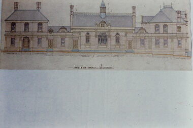 Kew Historical Society Inc
Slide - Architectural Drawing, Kew Public Offices, 1887
A civic campaign for new public offices developed in Kew in the 1880s. After much deliberation, the location chosen was the junction of Bulleen and Cotham Roads. The buildings were designed by George Watson and John Henry Harvey, architects within the Department of Public Works (Victoria). Building was commenced in 1887, and after one year, the buildings were opened. The Post Office was transferred to the new Commonwealth Government in 1901. The Police Station and Court House, sold by the Victorian Government to the City of Boroondara in 2007, are now a community cultural centre and performing arts venue.The buildings were listed on the Victorian Heritage Register Register (HO885) in 1991. They are historically and architecturally significant to the State Of Victoria because Watson and Harvey's designs exhibit diversity in integrating civil offices, they accommodate the apex of road junctions, and they demonstrate a departure from the contemporaneously favoured High Victorian Classical to the Queen Anne style in the design of civic buildings. 35mm colour transparency of an original plan by George Watson and John Henry Harvey, architects of the Department of Public Works (Victoria), in 1887 for New Public Offices at Kew. This plan was copied by the donor from an original held at the Commonwealth Archives in Brighton (Vic). The copy was made to illustrate a report that the donor made on ‘The functional planning design, building materials and construction methods of the Kew Post Office’ as part of course work at RMIT.BULLEEN ROAD ELEVATIONkew court house, kew police station, kew post office, architectural drawings, khs - slides, new public offices -- kew (vic.), architecture — queen anne style -
 Whitehorse Historical Society Inc.
Photograph, Green Family, Mitcham, c1943
No 172 Mitcham Road has been replaced by a large brick home and is now numbered 374.Two black & white photos of the Green Family in front of their home at 172 (now 374) Mitcham Road, Mitcham on cnr of Mitcham Road & Ormond Ave, Mitcham.green family, mitcham road mitcham 172 -
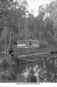 Eltham District Historical Society Inc
Photograph, The Rose Stereograph Company, A Pool, Eltham Road, Greensborough, c.1920
A boy of about ten years of age sits on the end of a fallen tree, which is resting in a natural pool in bushland. He is holding a stick gazing into the pool waters. He appears to be dressed in a schoolboy's uniform with close fitting short peaked cap, dark scarf or long sleeved jumper with polo neck and what appears to be a logo on the left breast, the ends of the sleeves turned over, dark shorts and dark long socks with ankle height lace up leather boots. The pool is located on the Eltham Road to Greensborough (present day Sherbourne, Karingal and St Helena roads) and is possibly part of the Karingal Yalloc somewhere near present day Ramptons Road Reserve. This glass plate negative was used to manufacture postcards (1:1 printing) for commercial sale by the Rose Sterograph Company and its subsidiaries. George Rose founded the Rose Stereograph Company in 1880 and was joined by Herbert (Bert) Cutts in the early 20th Century. The pair formed a lifetime working partnership and strong personal friendship. Assisted by George’s two sons, Herbert George and Walter, and later by Neil Cutts, the Rose Stereograph Company continued its operations for more than 140 years. The company was initially built on stereographs, but as cinema took over and stereographs fell out of fashion, the Rose Stereograph Company developed Australia’s first commercially viable photographic postcard business. Specialising in postcards of iconic historical moments and significant landmarks, The Rose Stereograph Company became a staple of the Australian travel industry.This remarkable collection of glass plate negatives, transparencies, and postcards – arguably Australia’s most significant photography collection outside of public hands – has been passed down through the generations, surviving war, relocation, and the harsh Victorian climate. The historic Rose Stereograph collection is the culmination of George Rose’s dream of capturing and preserving precious moments in time and remains the legacy of the Rose and Cutts families. It is with great sadness that the Cutts family says goodbye to a collection that spans five generations and 140 years. The Cutts family understands that for these historically important pieces to rest with one family is to deny others the pleasure of their custodianship.Glass Plate Negative Size: 9 x 14 cmA Pool, Eltham Road, Greensborougheltham, postcard, travel, rose stereograph company, glass plate negative, eltham road, greensborough, karingal road, karingal yallock, sherbourne road, st helena road, rampton's road reserve, schoolboy, peter and elizabeth pidgeon collection -
 Marysville & District Historical Society
Photograph (Item) - Black and white photograph, Unknown
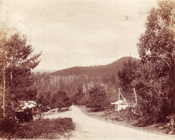
An early black and white photograph of the main road in Marysville in Victoria.An early black and white photograph of the main road in Marysville in Victoria. This road is now known as Murchison Street.murchison street, marysville, victoria, photograph -
 Marysville & District Historical Society
Photograph (Item) - Colour photograph, Unknown
A colour photograph taken of a house in Pack Road in Marysville in Victoria.A colour photograph taken of a house in Pack Road in Marysville in Victoria.pack road, marysville, victoria, photograph -
 Marysville & District Historical Society
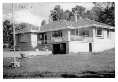
Photograph (Item) - Black and white photograph, 1961
A black and white photograph of a house in Falls Road in Marysville in Victoria.A black and white photograph of a house in Falls Road in Marysville in Victoria. This house belong the the Gianforte family.Falls Rdfalls road, marysville, victoria, photograph, gianforte family -
 Marysville & District Historical Society
Photograph (Item) - Colour photograph, Unknown
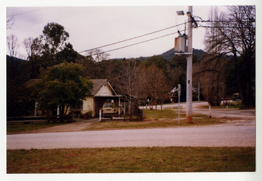
A colour photograph of Choppers Buxton Road House in Buxton in Victoria.A colour photograph of Choppers Buxton Road House in Buxton in Victoria. This building was destroyed in the 2009 Black Saturday bushfires.buxton, victoria, choppers buxton road house, 2009 black saturday bushfires -
 City of Kingston
Pamphlet - Colour, S. M. Reynolds, Estate Agent, Moorabbin Shire Hall Estate Second Section, c. 1930
Sales plan for land in the suburb of Moorabbin, bounded by South Road and Highbury Street, including Prince Street, Charming Street, Thomas Avenue and Keith Road.The developing urban area of Moorabbin within the City of Kingston. This land sale pamphlet illustrates the subdivision of land within the municipality and the changing demographic of the district as new houses are constructed close to infrastructure.Colour pamphlet advertising for private sale the Moorabbin Shire Hall Estate, Moorabbin. Incorporates a map of the estate bordered by South Road and Highbury Street, including Prince Street, Charming Street, Keith Road and Thomas Avenue.Handwritten in grey pencil on subdivision map below subdivision 63: £4 Handwritten in grey pencil on subdivision map below subdivision 66: 4 Handwritten in grey pencil on subdivision map below subdivision 80: 3. Handwritten in grey pencil on subdivision map below subdivision 81: 4 Handwritten in grey pencil on subdivision map below subdivision 83: 2 Handwritten in grey pencil on subdivision map below subdivision 96: £3 Handwritten in grey pencil on subdivision map below subdivision 97: 3 Handwritten in grey pencil on subdivision map to the left of subdivision 102: 3 Handwritten in grey pencil on subdivision map on the corner of Thomas Avenue and Highbury Street: vertical line next to a square with a cross in it.land sales, estate, moorabbin -
Whitehorse Historical Society Inc.
Article, Station on track, 2014
Mitcham and Rooks Road railway line crossings are being lowered to eliminate gates, and a new station for Mitcham, with 800 parking places, is being built.Mitcham and Rooks Road railway line crossings are being lowered to eliminate gates, and a new station for Mitcham, with 800 parking places, is being built. The roads and station will be opened on 25 January 2014.Mitcham and Rooks Road railway line crossings are being lowered to eliminate gates, and a new station for Mitcham, with 800 parking places, is being built. mitcham railway station, mitcham railway crossing -
 Glen Eira Historical Society
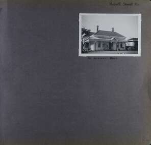
Album - Album page, Hobart Road, Circa 1972
This photograph is part of the Caulfield Historical Album 1972. This album was created in approximately 1972 as part of a project by the Caulfield Historical Society to assist in identifying buildings worthy of preservation. The album is related to a Survey the Caulfield Historical Society developed in collaboration with the National Trust of Australia (Victoria) and Caulfield City Council to identify historic buildings within the City of Caulfield that warranted the protection of a National Trust Classification. Principal photographer thought to be Trevor Hart, member of Caulfield Historical Society. Most photographs were taken between 1966-1972 with a small number of photographs being older and from unknown sources. All photographs are black and white except where stated, with 386 photographs over 198 pages. Page 84 of Photograph Album with one portrait photograph of a house on Hobart Road. Handwritten: Hobart Street RD - the word Street has been crossed out [top right] / 40 HOBART ROAD [Under photo] / 84 [bottom right]trevor hart, 1880's, cast iron verandah, murrumbeena, hobart road, victorian, columns, cast iron frieze, decorative brackets, iron roof, cast iron work, houses, chimneys -
 Brunswick Community History Group
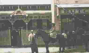
Photograph - Butcher's shop, Glenlyon Road, 1903
Copy print of butcher's shop in Glenlyon Road, 1903. The donor states that it was at #41 and the house was called Glen Wallace and probably owned by the Prowse family. Featured in Fusion, vol 26, issue 4, November 2012.Butcher's shop, Glenlyon Roadbutcher's shop, glenlyon road -
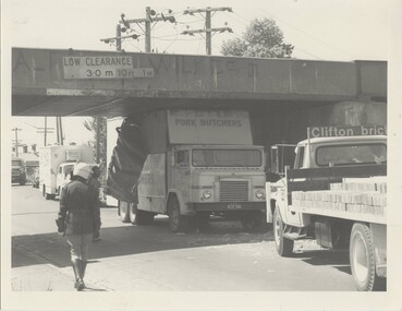 Melbourne Tram Museum
Photograph - Black & White Photograph/s, The Met, 1980's?
Black and White photograph of a butchers truck (K. Potts?) truck having collided with the rail over road bridge, Merri Parade Northcote, possibly c1980. MMTB Photograph - same handwriting as Reg item 288. Has a policeman walking alongside, the damaged truck, other vehicles including a Clifton Bricks truck. The bridge has the low clearance sign in metres, but with a newer imperial sign alongside.In ink on rear "Merri Road Northcote"trams, tramways, northcote, bridges, collision