Showing 876 items
matching shop on corner
-
 Flagstaff Hill Maritime Museum and Village
Flyer - Advertisement, Soap, Wright, Layman & Umney Ltd, Late 1940s
Wright’s Coal Tar Soap was a popular brand of household soap, manufactured by William Valentine Wright from 1867. The yellow soap was antiseptic, designed to cleanse the skin thoroughly. It was originally named Sapo Carbonis Detergens, which remains a registered trademark. The product was developed from ‘liquor carbonis detergens’, the liquid by-product of the distillation of coal to make coke. The liquid was made into an antiseptic soap for treating skin diseases. William Valentine Wright was born in 1826 at Aldeburgh, Suffolk. He was a wholesale druggist and chemist who had a small business, W.V. Wright & Co., at 11 Old Fish Street Hill, City of London, where he first sold the soap. In 1863 Wright moved his firm to small premises at 50 Southwark Street, Southwark, London, and not long afterwards M. Sellers and Mr Charles Noel Layman joined the partnership. The company's name changed to Wright, Layman & Umney, when Charles Umney (1843–1909) was taken into the partnership on June 17, 1876, after the death of M. Sellers. William Valentine Wight 1877. Rob Umney, great-great-grandson of Charles Umney, provided further details about the firm, adding that in the late 1960s, the Wright’s Coal Tar Soap business was taken over by LRC Products Ltd who sold it to Smith & Nephew in 1994. The current owners of the brand, Simple Health and Beauty Ltd are based in Solihull and the soap is called Wright's Traditional Soap ‘With coal tar fragrance’. The coal tar has been replaced with tea tree oil. There were concerns that ingredients in coal tar could cause cancer when a person is exposed to very high concentrations, such as in roofing and road paving. In January 2025 the current manufacturers still produce the Wright's Coal Tar Soap.The flier states that Wright's Coal Tar Soap was sold throughout the United Kingdom and Colonies, which includes Australia. The soap is representative of the many consumer goods sold at pharmacies and chemist shops across the world, such as Sambell and Son, who operated a pharmacy in Fairy Street, Warrnambool in the 19th century. The paper flier is rectangular and has printed text and a logo. The top right corner has stamped punch marks. It promotes Wright's Coal Tar Soap, made by Wright, Layman & Umney Ltd. England.Punch mark; "1176"flagstaff hill, maritime museum, wright's, coal tar soap, soap, bathing, antiseptic, washing, personal hygiene, london, southwark, chemist, pharmacist, colonies, wright's coal tar soap, sapo carboni detergens, punch marks, england, soap tablet, babies soap, nursery soap, advertising, poster, flyer, wright, layman & umney ltd., w.t. wrifght & co., soap bar, soap cake -
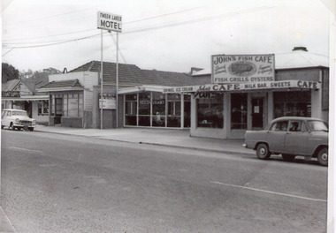 Lakes Entrance Historical Society
Photograph, 1960c
There was Billiard parlour down that end of town in the early 50’s. in Carstairs Ave. Rosmary Kavadis father (John Kostantinidis) owned it and it held 2 big tables 12 x 6 and the main games played were snooker and billiards. On the corner of Cairstairs Ave opposite Robin Hood Inn. The cafe Duckin, Mr and Mrs Kostantinidis bought it and on the side of that cafe down a verandah was the Billiard Room. It was very popular and a lot of the locals would play there. Rosemary was about 5 - 7 years old and had to stand on a fish box to play. It was very popular and next door was the Bamboo Coffee Shop run by Mr and Mrs Varney The'Duckin' became Peels bait shop Dot and Con Coucoulas took over the Bamboo and turned it into a motel not sure on the year and then bought the Duckin and demolished it. It was after Tween Lakes was built in 1959, as that was the first motel in townThe first 20 units and restaurant were built in 1959 with firsts guests on Dec. 22nd.1959. The units 21-27 plus the front residence and office were built in 1962.Black and white photographic copy of a short section of the Esplanade, which shows a fish shop, Bamboo Cafe, Tween Lakes Motel, and Johns Fish Shop. A 1950c Holden sedan parked in front of Fish Cafe, and Holden wagon in front of Bamboo Motel. Lakes Entrance Victoriatownship, motels, transport, restaurant -
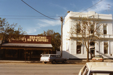
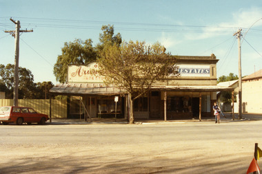 Charlton Golden Grains Museum Inc
Photograph, Arundell's Shoe Shop, High St Charlton c. 1987, c.1987
Arundell's Shoe Shop and Dalgety's Agency , centre of High St Charlton, north side c. 1987. Corner of High St and Williams Ave (now John Curtin Drive). Right hand building built by William Williams as a saddlery c. 1910. Arundell's Shoe Shop formerly ANA Boot and Shoe Shop established by John Arundell in 1901. The shop was sold by Vic Arundell in 1980 and closed. Next door was John Watson's Stock & Station Agents which later became Dalgety's. The end shop was the saddlery and then Bullock's grocery 1930's to 1970's. In 1957 became Charlton's first self service store. Became Australian Estates late 1970s. The shops were later demolished to make way for the Traveller's Rest. Part of a streetscape series taken in 1987 for the Charlton Shire.Colour photograph of three single-storey shops with corrugated tin verandahs. Signage on the buildings reads Arundell's SHOE STORE and ESTATES. Partially obscured by tree in front of the buildings. A red station wagon is parked on the LH side of the picture and a boy on a bicycle on the RH side. arundell, dalgety's, williams saddery, john watson stock & station agent, bullock's grocery, australian estates, arundell's shoe store, business, industry, charlton -
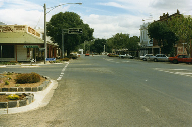 Charlton Golden Grains Museum Inc
Photograph, Pollard, Jenny, High Street Charlton 1989, c.1989
High Street Charlton streetscape. Shows Sweatman's North Central Panel Beaters (formerly Charlton Motors Pty Ltd garage), Heather's Choice Gift Shop (in the former Bilton/Dillon building built 1889), Westpac Bank, War Memorial (built 1923)Colour photograph of High St Charlton taken near the corner of Armstrong Street looking west. Garden beds in lower LH, road signs pointing to St Arnaud and to Mildura and Donald. North Central Panel Beaters on corner. Orange car driving west, person crossing the road, man standing near white ute in front of Westpac bank on RH side of photo. Heather's Choice sign on side of building. War Memorial at the end of the road.sweatmans, north central panel beaters, heather's gift shop, bilton building, westpac, war memorial, charlton, business, industry -
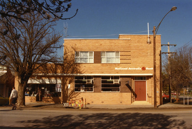 Charlton Golden Grains Museum Inc
Photograph, NAB High St Charlton 1987, c.1987
National Australia Bank building 1987. Established as the Bank of Victoria in 1876, later became Commercial Banking Company of Sydney. Current building built in c. 1940 and later became NAB. Part of Charlton Shire streetscape series taken in 1987.Colour photograph of the National Australia Bank, corner of High St and Armstrong St. Two story building with white curtains in two upper storey windows. Entrance doors are shut. Man crossing High St on LH side of photo. Someone in the entrance of the shop on the left of the Bank. Safety tape and barricade attached to parking sign in front of Bank.national australia bank, commercial banking company, bank of victoria, charlton shire, business, industry -
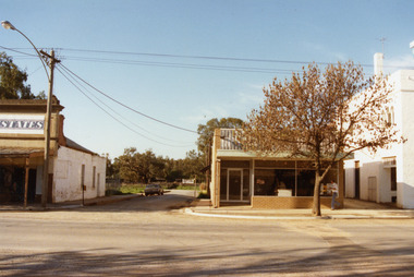
 Charlton Golden Grains Museum Inc
Photograph, West end, north side of High St Charlton 1987, c.1987
Arundell's Shoe Store moved to current location from the centre of High St c.1986 . Formerly E. Stowe's fruit shop and cafe. Westpac Bank, formerly Commonwealth Bank of Australasia built 1887. Part of the Shire Council streetscape series 1987.Colour photograph showing Arundell's Shoe Store on the left and the two storey, white Westpac Bank on the right. Blue and white station wagon parked in front of Arundell's and a yellow car is parked in front of the Bank. A white car is in the lower RH corner of the photo.arundell, arundell's shoe store, westpac, westpac bank, e. stowe, charlton, business, industry -
 Charlton Golden Grains Museum Inc
Photograph, Bourke's Butcher Shop High St Charlton c. 1987, c.1987
Corner of High St and Williams St (now Curtin Dve). Formerly the site of Wingfield's Hides and Wool agent and Frank O'Grady's solicitors office. In 1971 Jim Bannon moved his butcher business from the eastern end of High St to this newly built shop. He sold to Weirs in 1986 who sold to Frank Bourke in 1987. Part of a streetscape series taken for the Shire of Charlton in 1987. Bourke's butchers shop built 1971 for J Bannon. Shows area now occupied by the Travellers Rest complex.Colour photograph of single storey brick building with large glass window and door. Tree in front of building and a man walking past. Two storey white building to the right and a street and old single storey building on the left. Car parked in street on the LH side of the photo. Signage on the old building on the left reads STATES. jim bannon, frank bourke, wingfield's hides, frank o'grady, business, industry, charlton, butcher -
 Linton and District Historical Society Inc
Photograph, Ronald George Preston, 1918-2004
The young man is Ron Preston and the photograph shows the verandah and front of Preston's shop in Sussex Street, Linton. Ron was the son of George and Annie Preston. Preston's store which is pictured was on the corner of Sussex and Gillespie Streets, Linton.Black and white copy of original photograph, which shows a young man wearing a dark jacket and light-coloured trousers, who is sitting sideways on a motorcycle that has been parked outside a shop.ron preston, preston's shop -
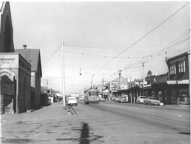 Melbourne Tram Museum
Photograph - Footscray - Victoria St - tram 678, Jim Seletto, c1960
The photograph shows MMTB X2 class tram No 678, southbound in Victoria St Footscray/Seddon on its way to Williamstown Road terminus at the corner with Walter St. On the left side is the Victoria St Methodist church. On the right is a shopping centre with signs for The Sun, The Herald, Keily, Solite floor, and Glen Valley tea. See item 8215 for a photo of X1 in the same street.Yields information about the trams in Victoria St Footscray / Seddon c1960.Black and White photograph with photographer's notes on rear"J Seletto photo"trams, x2 class, tram 678, victoria st, footscray -
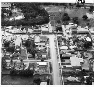 Charlton Golden Grains Museum Inc
Photograph, Aerial photo of Armstrong St, Charlton, c.1974
Aerial photo looking down Armstrong St. Camp street on the left, Shire Hall on the right. High St runs across the photo. The Avoca River is visible in the top LH side. The swimming pool and bowling green is above the rive. On High St (from L-R) Dr Surgery, H Bath Chemist, Grocery, Roy Dobson, Hairdresser, Stowe's, Westpac Bank (two storey white building), Dillon's Building, Globe Hotel, Charlton Club, butcher shop, Arundell's shoe shop, Watson's Stock & Station Agency, Bullock's grocery, Williams St (Curtin Ave), Bannon's Butchers, East Charlton Hotel, MB Luth & Co, Lou's cafe. The old sale yards are at the end of Williams Street. Camp St lower side (from L-R) Court House, Police residence, Police Station, Telecom on corner. The photo is thought to be taken from Ossie Sanderson's airplane in 1974.Black & white aerial photo looking down a broad street that ends in a t-intersection. There is a street that comes off to the left about 1/3 of the way up the photo. There is a large building directly opposite this street. In the upper right there is a two storey building with arches on its verandah. In the upper LH side there is a swimming pool and bowling greens.armstrong st charlton, charlton, business, industry, westpac bank, globe hotel, east charlton hotel, dillon building -
 Ballarat Tramway Museum
Postcard, Rose Stereograph Co, "Corner of Lydiard and Sturt Streets, Ballarat", c1929
postcard - titled "The Corner of Lydiard and Sturt Streets Ballarat Vic", photo looks southwest from the Post Office steps towards the southwest corner - has Craigs Hotel, National Mutual Life, town hall shops including Anderson Printer and the Town Hall in the picture along with Robbie Burns statue. The Rose Series Postcard No. P 1783. An ESCo tram is parked at the tram stop - No. 5? Several horse-drawn and motor vehicles are in the photograph. Wal Jack has dated the photo about 1930 on the rear of the postcard and about 1929 in his album notes - see item 5126 for the digital image. Yields information the buildings, buildings and scene at the intersection of Sturt and Lydiard St with a number of vehicles in the view.Postcard or copy photograph of Rose Stereograph Co. postcard, No P 1783ballarat, trams, tramways, esco, lydiard st, sturt st, town hall, tram 5 ? -
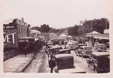 Clunes Museum
Photograph, PRINTED BY HARRINGTONS, 1939
PHOTOGRAPH OF CLUNES CENTENARY 1939 - STREET PARADEPHOTOGRAPH OF PARADE SEEN FROM CORNER FRASER ST. AND BALLARAT RD.CORNER FRASER ST. & BALLARAT RD.shops, miles garage, events and celebrations, back to clunes -
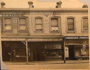 Ithacan Historical Society
Photograph, Andrew Black's Shoe Repair Shop
Andrew Black ran his successful shoe repair business in a shop in Swanston Street, Carlton situated just around the corner from Queensberry Street. The terrace of shops are no longer there but the hotel which stood on the corner of Swanston and Queensberry Streets is still there.Andrew Black's shoe repair business was one of many businesses that Ithacan successfully operated in the Melbourne CBD during the first half of the twentieth century.A non-digital scanned sepia photograph of a terrace of three double storey inner city shops. The businesses are from L-R: Newsagency, Shoe Repair and Hairdresser and Tobacconist. shoe repairs, greek businesses, swanston street, andrew black -
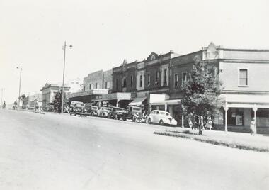 Ringwood and District Historical Society
Photograph, Maroondah Highway Central, Ringwood. Corner of Main and Adelaide Streets, 1949
Black and white photograph (2 copies- 1 large, 1 small)Written on backing sheet: "Corner of Main and Adelaide St. 1949". Image shows shops between Adelaide Street and Melbourne Street. -
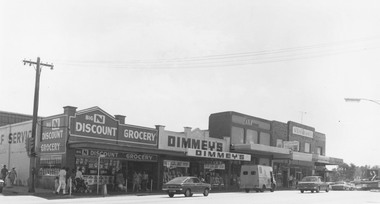 Ringwood and District Historical Society
Photograph, Maroondah Highway Central, Ringwood. Shops on the north-east corner of Melbourne Street and Maroondah Highway, c.1970
... , Ringwood. Shops on the north-east corner of Melbourne Street ...Black and white photographShops in photograph are 'Big N Discount Grocery, Dimmey's, ANZ Bank, Sound and Camera'. Safeway roof can be seen in the distance. -
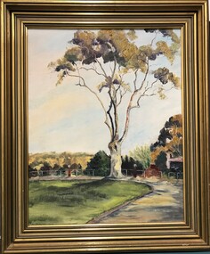 Heidelberg Golf Club
Painting - Framed Painting, Joy Kirwan, Gum tree at Heidelberg Golf Club by Joy Kirwan, 1978
... Course, painted by Joy Kirwan. The corner of the old pro shop... by Joy Kirwan. The corner of the old pro shop is on the right ...Oil painting of a lemon-scented gum at Heidelberg Golf Course, painted by Joy Kirwan. The corner of the old pro shop is on the right, the putting green in foreground.An original painting of part of the HGC groundsOil painting with timber frame Signed "Joy Kirwan"heidelberg golf club, joy kirwan, oil paintings -
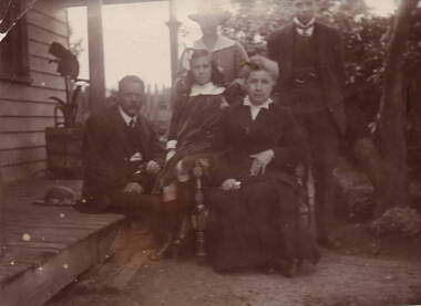 Sunbury Family History and Heritage Society Inc.
Photograph, Williams Family in Sunbury, c1910 - 1920
For many years the Williams family owned the Royal Hotel, which was on the corner of Brook and Evans Streets in Sunbury's main shopping centre and close to the railway precinct.A non-digital sepia photograph of a family seated in a garden beside a verandah of a weatherboard house. There are two men, two ladies and a young girl in the group.Written on the back in pen: WILLIAMS FAMILYwilliams family, royal hotel, hoteliers -
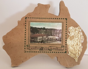 Linton and District Historical Society Inc
Souvenir, Greetings From Linton
The souvenir is believed to have been made by R.E. Hyatt.Home-made souvenir of Linton. Souvenir consists of a photograph of the Shire of Grenville office building in Sussex Street, Linton . Two shops are visible further along the street, and part of a sign for a butcher's shop is visible in the lower left corner of the photograph. The photograph has been mounted on a map of Australia which has been cut from very thick cardboard. A border made of small green squares is around the photograph, and underneath the photograph are the words "Greetings from Linton" enclosed by a scroll. The edge of the map has been painted green. A picture of a Koala has been cut from card or paper and painted silver and then been glued to the cardboard map to the right of the photograph. A wire metal stand has been attached to the back of the map with two small tacks.souvenirs, shire of grenville building, r.e. hyatt -
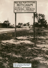 Whitehorse Historical Society Inc.
Photograph - Black and white photograph, Whitehorse Road Sign Mitcham, C1940s
Sign on south side of Whitehorse Road opposite Dunlavin Road, Mitcham, looking east. Early 1940s. Note in 1870 the area was known as Air Hill. Center of shot shows shop on west side of what later became Alexander Street and further east house on the corner of Peel Street. These signs are very similar to those erected in nearby Vermont.advertising signs, whitehorse road, mitcham, dunlavin road -
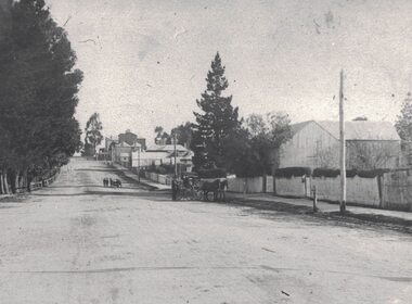 Linton and District Historical Society Inc
Photograph, View along Sussex Street, Linton, circa 1920
Dr Donaldson (Snr) owned the block of land on the corner of Sussex and Grant Streets, Linton. He had a ten-room house set on the back of the block (where the block backs on to Surrey Street), with a large barn fronting Sussex Street. Other identifiable buildings in the photograph are Ball Brothers blacksmith's shop, the Royal Standard Hotel on the corner of Sussex and Clyde Streets, the Shire Hall, Criterion House and Joseph Shepherd's store. The roof of Oscar Ball's house can be seen.Black and white copy of original photograph which shows houses and other buildings along Sussex Street. The view is to the south (up the hill) from the Ballarat entrance to Linton. A large barn, enclosed by a picket fence, is in the foreground. A cart drawn by two horses, with a man standing next to it, is in the street near the barn. Further along the street, a group of people appear to be wheeling a barrow or cart. Houses and other buildings can be seen along the street.sussex street linton, dr donaldson's barn, ball bros. blacksmith, royal standard hotel, shire of grenville offices linton, criterion house, joseph shepherd's store -
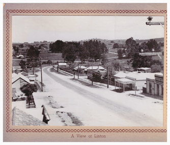 Linton and District Historical Society Inc
Postcard, A View at Linton, Sussex Street, Linton, view to south, circa 1940
The "Lorna, Bob and Elsie" in the inscription are probably Elsie McCorkell, her son Robert Hayward, and her daughter Lorna McCorkell.A very small photograph which has been made into a souvenir/postcard. The photograph is a view of Sussex Street, Linton, looking south-west. On the right of the photo are Ching's store, R. N. Sandow confectionery shop, a house next to it, and the first Bank of NSW building. Two houses are further down the road past Gillespie Street. On the left of the photo are the Edinburgh Bakery and a store with a verandah on the corner of Gillespie Street. The photograph is glued to a beige-coloured card which has a decorative edge cut into it. A printed border surrounds the photograph, and the words "A View at Linton" are printed underneath it. The card appears to have had the right-hand edge trimmed with scissors. Because of this, an inscription on the back of the card has been partially cut away. The inscription reads "-rs Whitehand & Doris / -with love from Lorna, Bob and Elsie".sussex street linton, buildings, shops, houses, sandow shop, ching's store, edinburgh bakery, postcards, souvenirs, lorna mccorkell, robert hayward, elsie mccorkell -
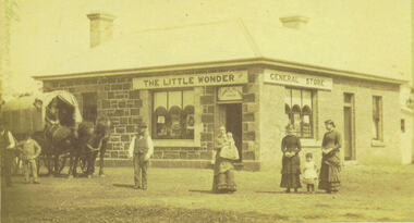 Bacchus Marsh & District Historical Society
Photograph, Alford's Little Wonder Store Bacchus Marsh 1883
The Little Wonder Store was built in 1883 from materials of the demolished Maddingley School. It was located on the corner of Grant Street and Labilliere Street. In 1886 James Alford obtained a licence to conduct the Railway Hotel and General Store there. A second storey was added later and the building continued to operate as the Railway Hotel. It was destroyed by fire in 1998. The photo also shows the covered wagon of a travelling salesman, who were known as ‘hawkers’, who were significant in the supply of goods and news to outlying towns and districts before the development of road and rail networks. Small sepia 'carte de viste' style unframed photograph on card with gold border framing photograph. Housed in the Jeremeas Family Album which contains photographs of Bacchus Marsh and District in 1883 by the photographers Stevenson and McNicoll. The photo shows a single-storey building of bluestone and brick with two signs on the front and side, the front sign reading “THE LITTLE WONDER” and the side sign “GENERAL STORE”. Above the door is a sign with the name ‘James Alford’. The windows display the merchandise of the store. Outside the store is a travelling salesman’s cart pulled by two horses. The salesman sits in the cart ready to drive off. Standing along the street outside the store are three men, three women and two young children.Printed On the front: Stevenson & McNicoll. Photo. 108 Elizabeth St. Melbourne. COPIES CAN BE OBTAINED AT ANY TIME. On the back: LIGHT & TRUTH inscribed on a banner surmounted by a representation of the rising sun. Copies of this Portrait can be had at any time by sending the Name and Post Office Money Order or Stamps for the amount of order to STEVENSON & McNICOLL LATE BENSON & STEVENSON, Photographers. 108 Elizabeth Street, MELBOURNE. stevenson and mcnicoll 1883 photographs of bacchus marsh and district, shops bacchus marsh, general stores bacchus marsh vic., hawkers, hotels bacchus marsh -
 Sunbury Family History and Heritage Society Inc.
Photograph, The Royal Hotel, C1939
... the windows and doors. The building occupies a street corner... a street corner in a shopping centre. The Royal Hotel Photograph ...The two storey building is the Royal Hotel which replaced an earlier single storey building that was destroyed by fire in 1935. It stood on a corner at the intersection of Brook and Evans Street. The new hotel was completed and opened in 1939 on the same site and still functions as a hotel today. The Royal Hotel was has occupied the same site in Sunbury's shopping strip for 163 years.A non-digital black and white photograph with a cream border of a brick two storey hotel with white trims around the windows and doors. The building occupies a street corner in a shopping centre.hotels, brook street, evans street, royal hotel -
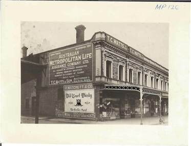 Bendigo Historical Society Inc.
Photograph - MATCHETT'S CORNER
Black and white photograph. Row of 2 storey shops with verandahs over footpath. Windows on 2nd story have columns each side and curved and painted pediments over. This photograph appears to be a photograph of 2000 - 505.01 (same stains in image)Frank A Jeffreeplace, building, commercial, see also 2000 - 505.01 -
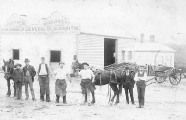 Ringwood and District Historical Society
Photograph, Maroondah Highway Central, Ringwood. Workers outside D.R. Kennedy's blacksmith shop, corner of Adelaide Street and Maroondah Highway
... . Kennedy's blacksmith shop, corner of Adelaide Street and Maroondah.... Kennedy's blacksmith shop, corner of Adelaide Street and Maroondah ...2 photographs (1 large black and white, 1 small sepia)Typed under large photograph: "Originally Mr Tommy Grants smithy in Maroondah Hwy. Built 1880." David Robert Kennedy took over the business from Ringwood's original blacksmith mr Tommy Grant in 1894. -
 Eltham District Historical Society Inc
Photograph - Digital Photograph, Alan King, Nillumbik Shire Offices, Greensborough, 30 March 2008
Nillumbik Shire Council transferred to the former Diamond Valley Shire Offices in Greensborough after municipal restructuing. The offices became the official Nillumbik Shire Council Offices on 16 October 1995. The former Shire of Diamond Valley Civic Centre or Shire Office building was officially opened on 26th February 1972. Archtiects were A.K. Lines, McFarlane & Marshall and it was built by L.U. Simon Pty Ltd, The Diamond Valley Shire had been created in 1964 from part of the City of Heidelberg. On December 15, 1994 the Shire of Nillumbik was established. Under the Council amalgamations imposed by the Kennett government, the Shire of Eltham, Shire of Diamond Valley and City of Heidelberg ceased to exist with the establishment of Nillumbik Shire Council and the City of Banyule.The new Nillumbik shire surrended the west riding from Eltham to Banyule but in place gained parts of the former Diamond Valley Shire which itself had been created in 1964 from parts of the City of Heidelberg. Three unelected and non-local Commissioners were put in place by the government bringing democracy into question by many members of the local community. The Commissioners determined to abandon the former Shire of Eltham offices located in Main Road, Eltham and in turn occupy the former Shire of Diamond Valley offices located at the boundary of the new shire with Banyule, in Civic Drive, Greensborough. In July 1996 the Commissioners sold the former Eltham Shire Offices and had them bulldozed leading to many years of communiity protest over the process and future development applications. The site has remained vacant ever since. Published: Nillumbik Now and Then / Marguerite Marshall 2008; photographs Alan King with Marguerite Marshall.; p43 It was the need for roads that led to this district’s first council. In 1853 a committee was formed to improve the rough roads, some in Kangaroo Ground being almost impassable in winter.1 The committee fundraised by voluntary levies and grants to improve in particular, the main road between Kangaroo Ground and the Plenty River. From this committee arose the Eltham District Road Board, in 1856, which was the precursor to the Eltham Shire Council. The Board’s first chairman was Kangaroo Ground farmer, John Barr. Secretary was the former committee’s secretary, Andrew Ross, Kangaroo Ground’s first school teacher, and founder of the district newspaper, The Evelyn Observer.2 Most of the board’s income came from a toll-house north of the Lower Plenty Bridge, which funded such projects as a road from Kangaroo Ground to the Caledonia Diggings. In 1871 the Shire of Eltham was proclaimed, with its boundaries the same as those of the Road Board, and Councillor A Donaldson of Kangaroo Ground was the first president. Eltham was at the southern tip of the shire, which extended north to Kinglake and east beyond Yarra Glen. In 1878, part of Kinglake was added to the shire, while the area east of Watts River, near Healesville was removed. In 1912, then again in 1958, the shire was further reduced. Yarra Glen, Steels Creek, Tarrawarra, parts of Healesville and Christmas Hills, were transferred to the Shire of Healesville. In 1972 a smaller area, at Kinglake, was transferred to the Shire of Yea, leaving 277 square kilometres in the Eltham Shire. Perhaps no other Victorian municipality has had so many meeting places. Although from 1858 to 1904, the council convened at the office in the home of Secretary Charles Wingrove, the board, and later the council, also met at other more central locations.3 The board moved from the Fountain of Friendship Hotel to the Eltham Courthouse, to the Kangaroo Ground schoolhouse. It then met at the Kangaroo Ground Hotel, which some considered put it in danger of interruptions by people ‘the worse for liquor’.4 In 1885 the council met at the hall on Mr J Donaldson’s land at Kangaroo Ground. After Wingrove’s retirement, the council rented space at the Kangaroo Ground General Store and Post Office. Then, in 1917, the council bought the former office of The Evelyn Observer, after its printing works transferred to Hurstbridge. In 1934, fire destroyed the shire office, which was temporarily relocated to the Kangaroo Ground home of Shire Secretary, Mr P J McMahon. In 1941, the shire office moved to a new building (which included a public hall) in Eltham, at the corner of Arthur Street and Main Road, where the Eltham Village Shopping Centre was eventually built. Growth required new offices, which opened in 1965, on the former Shillinglaw property in Main Road.5 In 1994, as part of municipal restructuring under the Jeff Kennett Liberal Government, most of the Eltham Shire formed part of the new Shire of Nillumbik. It joined with the north section of the Diamond Valley Shire and parts of the Healesville and Whittlesea municipalities. The Diamond Valley Shire had been created in 1964, from part of the City of Heidelberg. Turbulence followed Nillumbik Shire’s formation. Under the Commissioners the council transferred to the former Diamond Valley Shire offices in Greensborough, and the Eltham council offices were demolished. In March 1997 the first five-member Nillumbik Council was elected. But, in October 1998, the government suspended the council and appointed an administrator . Early in 1999, shire residents voted to increase councillors to nine: comprising five ward councillors and four shire-wide councillors. Elections were held in March 1999. Then, before the March 2002 elections, nine new wards were created.6 In 2008 these were reduced to seven. Today [2008] the council governs a varied population of more than 60,000 people living in townships and on bush properties in the green wedge.This collection of almost 130 photos about places and people within the Shire of Nillumbik, an urban and rural municipality in Melbourne's north, contributes to an understanding of the history of the Shire. Published in 2008 immediately prior to the Black Saturday bushfires of February 7, 2009, it documents sites that were impacted, and in some cases destroyed by the fires. It includes photographs taken especially for the publication, creating a unique time capsule representing the Shire in the early 21st century. It remains the most recent comprehenesive publication devoted to the Shire's history connecting local residents to the past. nillumbik now and then (marshall-king) collection, greensborough, nillumbik shire council offices, civic drive -
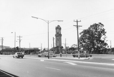 Ringwood and District Historical Society
Photograph, Maroondah Highway and Wantirna Road intersection 1969
Black and white photographImage shows clocktower in new location on corner of Maroondah Highway and Wantirna Road, and shops including Antwan's hair fashions and OPSM. -
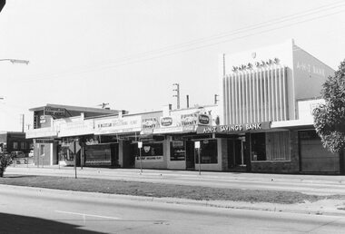 Ringwood and District Historical Society
Photograph, Maroondah Highway Central, Ringwood. Shops opposite old Town Hall site and Midway Arcade, 1969
... Shops include CBC Bank on corner of Railway Station...Shops include CBC Bank on corner of Railway Station ...Black and white photographShops include CBC Bank on corner of Railway Station entrance, and A.N.Z Bank at 116 Maroondah Highway. -
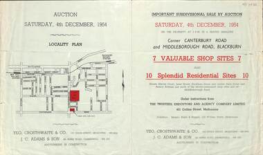 Whitehorse Historical Society Inc.
Pamphlet - Auction Flyer, Yeo, Crosthwaite & Co, Corner Canterbury Road and Middleborough Road, 4th December 1954
A green folded pamphlet advertising the sale of by auction of a shop and residential sites on the corner of Canterbury and Middleborough Roads, Blackburn on Saturday, 4 December 1954.A green folded pamphlet advertising the sale of by auction of a shop and residential sites on the corner of Canterbury and Middleborough Roads, Blackburn on Saturday, 4 December 1954.non-fictionA green folded pamphlet advertising the sale of by auction of a shop and residential sites on the corner of Canterbury and Middleborough Roads, Blackburn on Saturday, 4 December 1954.canterbury road blackburn, beck street, middleborough road blackburn, marion court, amery avenue, janet street, duckham street -
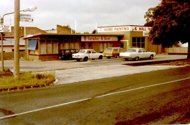 Surrey Hills Historical Society Collection
Photograph, Faraday & Kent, 172 Union Road Surrey Hills, 1979
This site was previously occupied by a Golden Fleece petrol station and later by Cobb & CO car rental. In Paul Towers bought the property from Faraday & Kent, for whom Norm Henderson was the proprietor, in 1996. In 2003 it was bought by Evan Lewis. (NOTE re source: undated note re verbal history given by un-named person).A colour photograph of the corner of Guildford Road and Union Road. There are four cars parked in front of a building. There is a sign identifying Faraday & Kent - home painting and wallpaper.guildford road, surrey hills, faraday & kent, businesses, paint shop, union road, norman henderson, evan lewis, paul towers, norm henderson