Showing 13827 items
matching tasmanian-built
-
 Wodonga & District Historical Society Inc
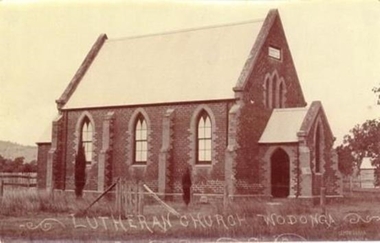
Photograph - Saint John's Lutheran Church, Wodonga
From the mid-1860s families of German ancestry arrived in the Wodonga district, travelling in groups from South Australia. The majority of these people were of the Lutheran religion. At first there was no Lutheran pastor or church in the area and they held services under the gum trees or in their homes once they had been built. The early arrivals included the Haeusler, Klinge, Bartel, Rothe and Paech families. They were later joined by members of the Muller, Lange, Pumpa, Lobbe, Heckendorf, Zeinert, Schubert, Schuster, Schubert and Terlich families amongst others. The first Lutheran Church was built in Havelock Street, Wodonga and was dedicated in 1875. This building was used for approximately 90 years until it was demolished and replaced by a temporary building and then a second church which was dedicated in 1978. The Ovens and Murray Advertiser on 4th August 1874 reported "The Rev. Goessling pastor of the German Lutheran Church, Gerogery has laid the foundation stone of the new church for the members of his denomination residing at Wodonga, in accordance with the rights of the church. The building was to be 30 feet by 20 feet and 14 feet high, of brick with white facings and Gothic windows. There was to be a porch and vestry, one at either end, measuring 8 feet by 10 feet". Plans were initiated to build a new church from the late 1990s. After many years of planning and hard work, the last service in the Saint John’s Lutheran Church in Havelock Street was held on Sunday 7th May 2023 and a new Church was constructed. From 14th May 2023 the Parish held its worship services in Luther Hall at Victory Lutheran College in Drage Road, West Wodonga. The new Saint John’s Church was consecrated on 18 August 2024.This photo is significant because it depicts the original Lutheran Church in Wodonga.A black and white photograph of an old stone church building.Lutheran Church Wodongawodonga churches, lutheran church wodonga -
 Bendigo Military Museum
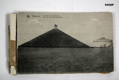
Postcard - POSTCARD BOOKLET, PHOTOGRAPHIC, 1910-1919
The images of the Battle scene are; the Lion Mound, Waterloo, The Three Monuments, French Monument, Farm La Haye Sainte, The Prussian Monument, Hougament farm, The Lion, Farm Papelottre, The Belle Alliance Building.This is a bound booklet of Black and White images of the Battle of Waterloo area. On the photos is the caption in French and English. The front cover is missing. Some of the postcards are detached on the "dotted edge". The first two cards have a letter written in pencil from soldier J. Burns to his mum.On the back of photo 1 & 2 is written the letter from J. Burns to his Mum. Dated Bouffioul - Belgium. 3-3-19. Dear Mum, These are a few views of Waterloo, we went right up to the top of this place. This is where all the dead soldiers were buried, so they built this big mound it. It is a good walk to get to the top. - This is where all the battle was, around these ....... Well Mum I am ok again, this is a little souvenir. I can say I have been on the Fields of Waterloo. Well Mum I received another parcel from........? today and it was good too. I will write a letter later so Good Bye Dear Mum for the present, from your loving son James. On the rear post card, written in pencil is: - No.60893 Pte J Burns, 5th Battalion A.I.F. France.postcards, battle of waterloo -
 Blacksmith's Cottage and Forge
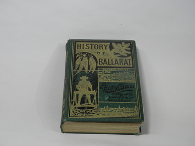
Book, F.W. Niven and Co, History of Ballarat, 1887
This book came into our collection via a donation to the Book Barn, which operates as a second-hand book shop. The donor is unknown.This book was published in 1887, a time of consolidation of wealth after the initial gold rushes in Ballarat in the 1850s. Its full title is 'History of Ballarat from the First Pastoral Settlement to the Present Time.' By William Bramwell Withers, Journalist. Second Edition with Plans, Ilustrations and Original Documents. It is an invaluable history of the origins of Ballarat and its mining history, with a chapter devoted to the Eureka Stockade. Book bound in green cloth on hard cover. On cover: Title incised in black on gold: HISTORY/OF/BALLARAT In gold: REVISED EDITION In black:By/W.B.Withers/PUBLISHED/BY/F.W.NIVEN &Co/Ballarat. Front cover embossed with gold pictures, one of a spray of wattle, one of a spray of eucalyptus leaves, a picture of a miner standing at a winch, and two panoramas of Ballarat, one in its early days as a gold-mining camp, and one as a built-up city. On spine: In green on gold: HISTORY/OF/BALLARAT : BY W.B.WITHERS 1887 Picture of two miners in a lift cage descending a mine shaft. On back cover: In black, picture of an aborigine looking into the sun, which is either rising or setting. On inside front cover: label pasted in. Inscription in gold: PRESENTED TO/THE/MEMBERS/OF THE/Empire Commerce Congress/BY/BALLARAT'S PIONEER DIGGER,/MR.JAMES ODDIE,1851. Front brown flyleaf partially torn off. ballarat gold rush, w.b.withers, eureka stockade, mining history, early maps of ballarat, mr james oddie, empire commerce congress -
 Phillip Island and District Historical Society Inc.
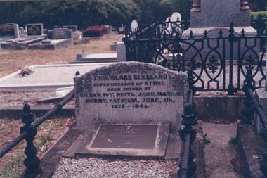
Photograph Album, Kodak, Phillip Island Cemetery, c 1990
The Album was compiled by Nancy McHaffie late 1990's, with the assistance of Edith Jeffery's, with her book "Garden of Memories" and extensive knowledge of Phillip Island. The Cemetery lies back from the road and is surrounded by Manna Gums, rare Peppermint Gums, Blackwoods and other native trees. In all 25 acres of land were set aside as Crown Land in the land settlement of 1868. There are 6.2 acres of wetlands near the cemetery entrance.466-29: John Blake Cleeland lived in the house his father built, "Woolamai House" in Newhaven. His property ran cattle, horses and angora goats. He had a great love of the sea although he never went to sea. He logged all shipping movements around the Eastern passage of Westernport. He was Captain-in-charge of the Rocket Apparatus Station at Newhaven, which was a rescue service for shipping. 466-30: Eleanor Blake (nee Lucas) came out from Ireland in 1860 together with her husband Edward Hudson Blake and children. For most of her life in Australia, she resided at Hastings. Her youngest daughter Isabella married John Cleeland, both of whom are buried in the cemetery. Eleanor moved from Hastings to "Woolamai House" in later years. 466-31: Margaret Jane Cleeland (nee Kennon) married John Blake Cleeland on May 21st 1903 at South Yarra. She was the daughter of Stanley Stowell Kennon, a farmer and her mother was Isabella (nee Turner). Margaret died in 1909 at the age of 30 years. At the time of her death she was survived by three children: Eileen Henrietta, Ivy Florence & Reita Vermont.phillip island cemetery, nancy mchaffie, edith jeffery, cleeland -
 Port Melbourne Historical & Preservation Society
Film - Video Recording - Digital, I Wish I Had Been There, 28 Jul 2020
The Port Melbourne Historical and Preservation made history on the 28 July 2020 when, because of the COVID-19 pandemic, we hosted our first meeting via Zoom.Digital video recording of PMHPS meeting held via Zoom on 28 July 2020. Eight members spoke on the theme “I Wish I Had Been There …” Margaret BRIDE wishes she had there when Wilbraham LIARDET had ridden up and down Bay Street proclaiming the separation of Victoria from New South Wales. John MAY wishes he was there in 1937 when Port Melbourne and Williamstown Football Clubs swapped players. Sue LEONG wishes she was there in July, 1901 in front of the building where she now lives but previously was a stables and carrier’s business. David RADCLIFFE wishes he was there in March, 1924 when the HMS Hood and the HMS Repulse arrived in Port Melbourne. Beris CAMPBELL wishes she was there in 1974 at Arch TODD's Mayoral Ball at Port Melbourne Town Hall. Garry SMART wishes he was there for the Sandridge Council meeting held at the newly built court house on 23 August 1860. Helen BARRY wishes she was there at the Graham Street railway gates where her grandfather proposed to her grandmother. Lex JOHNSON wishes he was there on the last Saturday in August, 1946 when Port Melbourne took on Coburg at North Port Oval.margaret bride, wilbraham frederick evelyn liardet, wfe liardet, separation, john may, port melbourne football club, williamstown football club, sue leong, knight's transport, david radcliffe, hms hood, hms repulse, beris campbell, archibald (arch) todd, celebations - balls, gary smart, local government - municipal district of sandridge, court house, helen barry, lex johnston, coburg football club -
 Southern Sherbrooke Historical Society Inc.
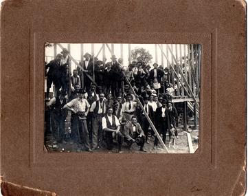
Photograph, Watson's Photos, Belgrave, Building Austral Hall, Belgrave, 1920
Black and White photo on a brown cardboard mount, showing a large group of men (about 30) and children (about 6) in front of and on the wooden frame of the partially constructed Belgrave Catholic Church Hall, Austral Hall, corner of (now) Reynolds Lane & Burwood Highway. The men are dressed in various combinations of hats, ties, shirts, jackets, trousers and work aprons. Some have tool belts or are holding hammers and other tools. Two small girls are seated on their fathers' laps. A man is sitting on his haunches at the front. He is wearing a suit and loose bow tie and holding a hat. He appears to be an official. Another man is patting or holding a dog. The building seems to have two walls partially constructed. There are trees visible in the background which are on the high side of the main road of Belgrave. A moulded brown cardboard mount measures 24.7 X 20.00. On the reverse side is written in pencil, 'Building Church hall/ at/ Belgrave/ Saturday 11th Dec 1920.' There is a stamped business name which reads 'Watson's/ photos/ Belgrave.' The Hall was built by largely volunteer labour as the Austral Hall, financed largely by Harry Luscombe's dances and functions. The land was donated by the Buckley Family. On the reverse side is written in pencil, 'Building Church hall/ at/ Belgrave/ Saturday 11th Dec 1920.' There is a stamped business name which reads 'Watson's/ photos/ Belgrave.' -
 Kew Historical Society Inc
Plan, Melbourne & Metropolitan Board of Works. Borough of Kew Detail Plan No.1579, 1904
The Melbourne and Metropolitan Board of Works (MMBW) plans were produced from the 1890s to the 1950s. They were crucial to the design and development of Melbourne's sewerage and drainage system. The plans, at a scale of 40 feet to 1 inch (1:480), provide a detailed historical record of Melbourne streetscapes and environmental features. Each plan covers one or two street blocks (roughly six streets), showing details of buildings, including garden layouts and ownership boundaries, and features such as laneways, drains, bridges, parks, municipal boundaries and other prominent landmarks as they existed at the time each plan was produced. (Source: State Library of Victoria). This plan forms part of a large group of MMBW plans and maps that was donated to the Society by the Mr Poulter, City Engineer of the City of Kew in 1989. Within this collection, thirty-five hand-coloured plans, backed with linen, are of statewide significance as they include annotations that provide details of construction materials used in buildings in the first decade of the 20th century as well as additional information about land ownership and usage. The copies in the Public Record Office Victoria and the State Library of Victoria are monochrome versions which do not denote building materials so that the maps in this collection are invaluable and unique tools for researchers and heritage consultants. A number of the plans are not held in the collection of the State Library of Victoria so they have the additional attribute of rarity.Original survey plan, issued by the MMBW to a contractor with responsibility for constructing sewers in the area identified on the plan within the Borough of Kew. The plan was at some stage hand-coloured, possibly by the contractor, but more likely by officers working in the Engineering Department of the Borough and later Town, then City of Kew. The hand-coloured sections of buildings on the plan were used to denote masonry or brick constructions (pink), weatherboard constructions (yellow), and public buildings (grey). While MMBW Plan No.1579 does not include many buildings, those that it does show are significant to Kew’s history. These include the ‘Kew [Railway] Station’ in Denmark Street and the ‘Recreation Hall’ and rear courts off Wellington Street. The plan shows the outline of the Recreation Hall, constructed in 1880, at the rear of which is listed a bowling green, two tennis courts, a ‘skittle alley’ and a pavilion. When the Hall was first built, the Kew Cricket Club occupied an adjacent ground, however in 1885 this was acquired by the State Government as the future location of the Kew Railway Station. The Plan also shows a single oval at Xavier College. This oval was completed in 1883. One of the current ovals conforms to this oval’s original shape and position in the school grounds.melbourne and metropolitan board of works, detail plans, maps - borough of kew, mmbw 1579, cartography -
 Kew Historical Society Inc
Plan, Melbourne & Metropolitan Board of Works : Contour Plan of Melbourne & Suburbs : Melbourne Sewage, 1894
The Melbourne and Metropolitan Board of Works (MMBW) plans were produced from the 1890s to the 1950s. They were crucial to the design and development of Melbourne's sewerage and drainage system. This plan forms part of a large group of MMBW plans and maps that was donated to the Society by the Mr Poulter, City Engineer of the City of Kew in 1989. Within this collection, thirty-five hand-coloured plans, backed with linen, are of statewide significance as they include annotations that provide details of construction materials used in buildings in the first decade of the 20th century as well as additional information about land ownership and usage. The copies in the Public Record Office Victoria and the State Library of Victoria are monochrome versions which do not denote building materials so that the maps in this collection are invaluable and unique tools for researchers and heritage consultants. A number of the plans are not held in the collection of the State Library of Victoria so they have the additional attribute of rarity.Digital copy of an original MMBW plan. This contour plan shows the area identified by the MMBW for purposes of drainage and sewerage in 1894. The suburbs represented extend from Williamstown in the west to Bulleen in the east, and from Preston in the north, south to Sandringham. Suburbs are outlined in coloured ink. Red lines indicate main and branch sewers in existence at the beginning of 1894 in central and inner Melbourne. These extended as far as Williamstown and Brighton, but not yet as far as Kew, where sewering did not commence until 1901. Contour lines show the topography, which was important for indicating the fall of the land for the laying of sewers and drainage channels. Kew appears to be fairly undeveloped at this date except for railway lines and stations (the Kew and Outer Circle lines), main roads, the Kew Lunatic Asylum Reserve and Studley Park. However, the contour plan does not accurately represent the density of settlement, nor the large number of houses, which were being built in Kew and other suburbs from the 1850s to the land boom of the late 1880’s and early 1890’s. This plan is part of a large and historically significant group of MMBW plans and maps that was donated to the Society by the Mr Poulter, City Engineer of the City of Kew in 1989.mmbw contour plan of melbourne and suburbs, melbourne and metropolitan board of works, melbourne sewage, cartography -
 Kew Historical Society Inc
Plan, Melbourne & Metropolitan Board of Works : Borough of Kew : Detail Plan No.1570, 1905
The Melbourne and Metropolitan Board of Works (MMBW) plans were produced from the 1890s to the 1950s. They were crucial to the design and development of Melbourne's sewerage and drainage system. The plans, at a scale of 40 feet to 1 inch (1:480), provide a detailed historical record of Melbourne streetscapes and environmental features. Each plan covers one or two street blocks (roughly six streets), showing details of buildings, including garden layouts and ownership boundaries, and features such as laneways, drains, bridges, parks, municipal boundaries and other prominent landmarks as they existed at the time each plan was produced. (Source: State Library of Victoria)This plan forms part of a large group of MMBW plans and maps that was donated to the Society by the Mr Poulter, City Engineer of the City of Kew in 1989. Within this collection, thirty-five hand-coloured plans, backed with linen, are of statewide significance as they include annotations that provide details of construction materials used in buildings in the first decade of the 20th century as well as additional information about land ownership and usage. The copies in the Public Record Office Victoria and the State Library of Victoria are monochrome versions which do not denote building materials so that the maps in this collection are invaluable and unique tools for researchers and heritage consultants. A number of the plans are not held in the collection of the State Library of Victoria so they have the additional attribute of rarity.Original survey plan, issued by the MMBW to a contractor with responsibility for constructing sewers in the area identified on the plan within the Borough of Kew. The plan was at some stage hand-coloured, possibly by the contractor, but more likely by officers working in the Engineering Department of the Borough and later Town, then City of Kew. The hand-coloured sections of buildings on the plan were used to denote masonry or brick constructions (pink), weatherboard constructions (yellow), and public buildings (grey). Plan No.1570 shows the layout of gardens and houses in Sackville Street, Davis Street, Wrixon Street, and Fitzwilliam Street in 1904. While Thomas Street is included on the map, at this stage no houses had been built. The plan identifies two named houses: ‘Fairview’ and ‘Kylemore’. Fairview is more fully delineated in Plan No.1563. Kylemore is one of the few houses in Kew designed by John Beswicke. The most notable owner of Kylemore was William Whitehead, who owned the house between 1895 and 1900. In 1894, Australian newspapers reported the marriage of Whitehead’s daughter to Dr. Gerald Eugene Cussen, the brother of Sir Leo Cussen, the Supreme Court Judge. The married couple was to live at ‘Wilton’ (now the Kew RSL) from 1911-15.melbourne and metropolitan board of works, detail plans, mmbw 1570, cartography -
 Kew Historical Society Inc
Plan, Melbourne & Metropolitan Board of Works : Borough of Kew : Detail Plan No.1572, 1905
The Melbourne and Metropolitan Board of Works (MMBW) plans were produced from the 1890s to the 1950s. They were crucial to the design and development of Melbourne's sewerage and drainage system. The plans, at a scale of 40 feet to 1 inch (1:480), provide a detailed historical record of Melbourne streetscapes and environmental features. Each plan covers one or two street blocks (roughly six streets), showing details of buildings, including garden layouts and ownership boundaries, and features such as laneways, drains, bridges, parks, municipal boundaries and other prominent landmarks as they existed at the time each plan was produced. (Source: State Library of Victoria)This plan forms part of a large group of MMBW plans and maps that was donated to the Society by the Mr Poulter, City Engineer of the City of Kew in 1989. Within this collection, thirty-five hand-coloured plans, backed with linen, are of statewide significance as they include annotations that provide details of construction materials used in buildings in the first decade of the 20th century as well as additional information about land ownership and usage. The copies in the Public Record Office Victoria and the State Library of Victoria are monochrome versions which do not denote building materials so that the maps in this collection are invaluable and unique tools for researchers and heritage consultants. A number of the plans are not held in the collection of the State Library of Victoria so they have the additional attribute of rarity.Original survey plan, issued by the MMBW to a contractor with responsibility for constructing sewers in the area identified on the plan within the Borough of Kew. The plan was at some stage hand-coloured, possibly by the contractor, but more likely by officers working in the Engineering Department of the Borough and later Town, then City of Kew. The hand-coloured sections of buildings on the plan were used to denote masonry or brick constructions (pink), weatherboard constructions (yellow), and public buildings (grey). Plan No. 1572 represents the built environment bordered by Barkers Road, Wrixon Street, Edgevale Road and Fitzwilliam Street. Other streets identified on the plan include Stansell Street. Plan 1572 shows that by 1903-05, there was only patchy development in this area of Kew, mainly on Edgevale Road and Fitzwilliam Street. Only two named houses are identified: the quaintly named ‘Tweed Cottage’, and ‘Mendip’. The earliest reference to Treed Cottage in Australian newspapers is to the death of Walter Thompson, aged 74 who was a resident there in 1885. His youngest daughter was to die there in 1908. Mendip to the north of Tweed Cottage was owned by Henry Thompson; he was to die in 1901; his wife in 1932. At this period of time, Malin Street and Clivedon Court did not extend to Barkers Road.melbourne and metropolitan board of works, detail plans, mmbw 1572, cartography -
 Mt Dandenong & District Historical Society Inc.
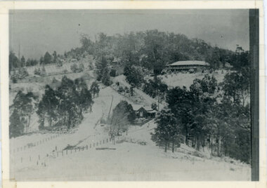
Photograph, Kalorama Gap Under Snow 1921, 1921
View of Kalorama Gap under snow taken in 1921. Mountjoy Guest House is at top right and Beulah Tea Rooms is in the centre. This photograph has a detailed inscription on the back handwritten by John Lundy-Clarke in 1974.Kalorama Gap under snow 1921 The leafless elm trees are low in the centre and the dual nature of the nearer one can be clearly seen, two small suckers of the older farther tree being twisted together in 1898 by Fred Jeeves. The older tree was planted 1880. Mrs Hands shop can be clearly seen, which was the Mount Dandenong North Post Office. The old Main Road runs up the centre of the picture and turns to the right and disappears behind “Mountjoy” the big guest house built by Paynters in 1905 and sold to Ellis Jeeves 1908, whose family ran it till 1943. At the bend of the road behind the big pine tree and the dark blackwood can be seen faintly the gable of Price’s house that contained the first shop on the mount. Above it is H Walker’s cottage on Ridge Road that still exists, his homestead is on the left of the picture on the same level. Below this house and to the left can be seen Ted Prices hay and corn store. The present estate agency lies between these two buildings, on the road which had recently been built. This can be seen winding from the lower left corner of picture to the left of the elms. The CRB had recently fenced the road and this is clearly seen as it circles behind trees in the left centre. Barber’s Road crosses CRB Road to the left of the dray under the leafless elm and the Coach Road dives down to the right just behind the pair of blackwoods to right of the elms. The picture was taken from just above the boundary of Isaac Jeeves’s selection Crown Allotment “C” (Jeeves Saddle) which stretched across the Gap to the other side of Mrs Hand’s shop, monopolising the gap from 1871 to 1879. Price’s house remains partly as the small house – “Mirra Laken”. kalorama gap, fiveways, post office, mountjoy, guest house, snow -
 The Beechworth Burke Museum
Photograph
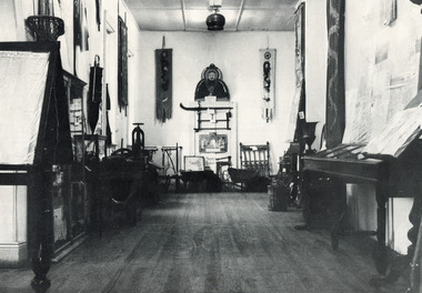
This black and white photograph is estimated to have been taken c1900 inside the Burke Museum. Several objects part of the museum collection at the time can be seen, with a high number of Asian influence objects visible; potentially Chinese in origin, as several Chinese villages were located around Beechworth and across Spring Creek, from the mid 1800s. The Burke Museum is part of the Precinct of Beechworth, which was established upon the discovery of gold in 1852. Originally built as the Beechworth Athenaeum in 1857, the museum was later renamed to the Robert O'Hara Burke Memorial Museum, more commonly known as the Burke Museum, in honour of the famous explorer and former Beechworth Superintendent of Police, Robert O'Hara Burke, after his death in 1861 at Coopers Creek during the famed ill-fated Burke and Wills expedition.This photograph is contextually, historically and socially significant due to its connection to both the Burke Museum and Chinese culture in and around Beechworth during the mid-1800s through to 1900s. Around 4700 people of Chinese heritage lived at the Ovens goldfield by April of 1857, representing one-quarter of the entire population at the time. The object holds strong representativeness to the history of the Burke Museum and to the objects in its collection. Its interpretive capacity could be supported and enhanced with other photographs and objects in the collection. Collectively, these records and objects could provide an insight into the museum's collection and its relationship with the origins of the objects.Black and white rectangular photograph printed on paper. Unmounted; taped to paper. beechworth, spring creek, chinese, burke museum, immigration, chinese immigration, ovens goldfield, china, museum, robert o'hara burke, burke and wills expedition, burke and wills, goldfields -
 The Beechworth Burke Museum
Photograph
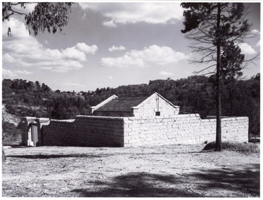
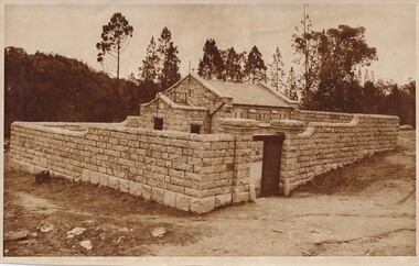
The photograph is of the Powder Magazine and gorge in Beechworth. The Magazine was built for six hundred and ninety-seven pounds in 1859 by "T Dawson and company." However, the walls were constructed later in 1860 by "Atchison and Lumsden," a different building firm. The Beechworth Magazine was one of many made by the government for the storage of gunpowder. However, the building eventually stopped being used as the mining decreased in the area, finally becoming unsused with the invention of nitro-glycerine compounds. The magazine was created to hold large quantities of gunpowder and much of its design was to hinder the prospective of damage. These safety features included double arched foundations and an arched inner roof, which would move a possible explosion upwards. Also, a process of lighting conductors, ventilation and heavy granite walls were incorporated in the designThe photograph shows historic significance due to its association with the mining era in Beechworth in the late 1800s. The photo shows the Powder Magazine after construction, most likely when it was storing gunpowder during a signifiant time period for the region.Black and white photograph printed on paper.beechworth, powder magazine, gunpowder, mining, beechworth powder magazine, explosives, atchison and lumsden, t dawson and company, gorge, granite, granite building, 1860 -
 Orbost & District Historical Society
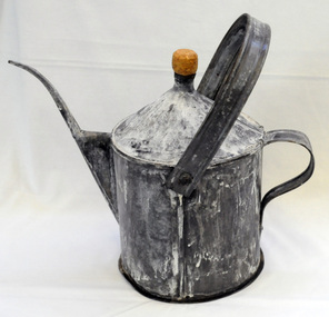
poison pot, Smith, R. & E, 1940's
This item was used on P.C. Toby Nixon and Grace Nixon's farm, "Rolling Downs" at Bete Bolong. During WW11 the farm grew carrots, red beet, cabbages, beans and maize. Because of labour shortages the government built a Prisoner of War Camp on Russell's Hill. The manager, Dick Northrope, used three Italian prisoners to frill ring small trees and shrubs between crop harvesting. The introduction of ‘frill ringing’ and poisoning with arsenical tree killers in the 1940's and 1950's helped reduce the amount of labour required and trees on more country were treated. This enabled the hill country at Bete Bolong to become more productive. The dead trees and shrubs were later cleared by Erle Broome's D7 caterpillar bulldozer. This was the first big area of 230 acres to be cleared in the Orbost district. Soon after entering World War 11 Australia was asked by Britain to accept and guard large numbers of 'enemy aliens' and prisoners of war. The British government felt that it could not afford to feed large numbers of prisoners and it was believed that once in Australia the internees would have no chance of escape. Eager to show solidarity with Britain's cause, Australia readily agreed and decided to place the prisoners in a number of different camps scattered around the country and guard them with reservists and soldiers too unfit to serve overseas. There was an internment camp at Bete Bolong, Orbost. This item is an example of an item used by the Italian P.O.W.'s residing there. It is also an example of an agricultural tool not commonly used today.A galvanized iron watering can which has been used to hold poison for ring barking trees (possibly arsenic). It has a narrow spout. There is a handle at the back and a folding handle on the top. The top is conical with an opening for a cork. agriculture prisoner-of-war-camp tree-removal land-clearing -
 Orbost & District Historical Society
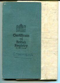
certificate, 23.2.1911
The Stormbird was built in Southport Tasmania in 1874 and was originally a steamer registered in Hobart. 1876. It was re-registered many times with different owners: William Fergusson & S.Reeves, reg. Port Adelaide; 1878: G.McKay, C.Heath & J.Yeo; 1883: G.S.Simmonds. It made regular voyages from Port Victoria. In 1893 on November14 Stormbird sank at her wharf, near Honey Street, after being struck by the Tenterden. It was raised (29 Nov) & repaired.In 1902. It was registered to A.Le Messurier. In 1904 it was registered to J.& A.Tainsh. This certificate is the record of registration for George Tainsh, a master mariner, Alice Thompson, a widow and John Tainsh, master mariner. 1922. The Stormbird was eventually lost on a voyage Madang to Wewak with the loss of two lives. This was after 1968. It had been changed to a sailing ship with an auxiliary engine in 1938.This certificate is a useful research tool and is a valuable source of information on maritime history.A small, blue folder containing a certificate of British Registry for the ship "Stormbird". Black text with additional hand-written details in red added in 1938. The certificate gives details of size, tonnage and engine. The owners are listed and it is dated 24th May, 1922 and signed by the Registrar of Shipping, Ernest Hall.stormbird-registration tainsh -
 Orbost & District Historical Society
framed black and white photograph, C1900
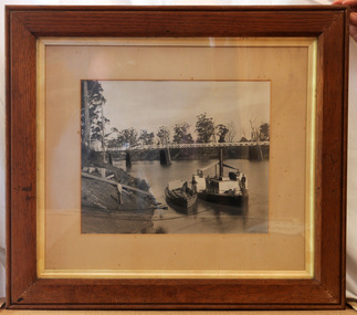
The P.S. Curlip was built by Samuel Richardson & Sons at a Tabbara sawmill in 1889. Alan Richardson, shown in the photograph, was the captain. It was operated along the Snowy River in Australia's Gippsland region between 1890 and 1919, before being washed out to sea, and broken on Marlo beach, by a flash flood in 1919. James Winchester was born in Geelong in 1856. He first sailed into Marlo, aged 15 and returned in the 1870's. he worked on the snagging punt on the Snowy River and also on the Paddle Steamer Curlip which towed the barges to collect the maize grown along the Snowy River. Wooden chutes were constructed along the river banks to load bagged maize onto the barges. The bags of maize were sent down the chutes into the waiting barges. This is a pictorial record of the iconic Paddle Steamer Curlip which has a significant association with Orbost. It records the method of loading maize onto barges through a wooden cchute.A large framed black / white photograph of the Paddle Steamer Curlip and a barge on a river. The barge is being loaded with maize through a large chute. In the background is the Snowy River bridge. the frame is wood. There is also a copy.on back of copy - " Jim Winchester, Alan & Frank Richardson, Curlip - barge & chute for loading maize"p.s.-curlip transport-shipping richardson winchester-james snowy-river maize-loading -
 Orbost & District Historical Society
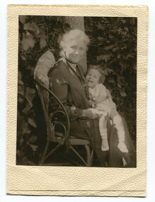
black and white photograph, first half 20th century
The lady in this photograph is probably Mrs Eveline Trevaskis who taught at the Wairewa School. Mrs. Trevaskis taught school from her early 20’s in different parts of Victoria. She gave it up to get married, has four children and 11 grand-children. Four of her grand-children are at Wairewa school. Mrs. Trevaskis went back to teaching during the wartime teacher shortage. She relieved at Buchan East State School for two years, getting up at 3.45 am to drive the 24 miles in pony and jinker. Wairewa State School, No. 3739 was built in 1923. The school closed at the end of 1973. Mrs Trevaskis was the teacher at Wairewa 1919-22 and 1945-1956. ( more information in News letter No. 123 NOVEMBER, 2015 - John Phillips)This item is associated with the history of education in East Gippsland.A black / white photograph in a small cream coloured folio. It is of an older lady seated on a chair with a young child on her lap. The child is laughing.inside cover - "Teacher at Wairewa"educatio-east-gippsland wairewa-state-school trevaskis-eveline -
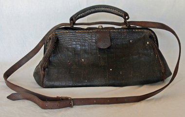 Orbost & District Historical Society
bookmaker's bag, late 19th century
A Gladstone bag is a small portmanteau suitcase built over a rigid frame which could separate into two equal sections. Unlike a suitcase, a Gladstone bag is deeper in proportion to its length.They are typically made of stiff leather and often belted with lanyards. The bags are named after William Ewart Gladstone (1809–1898), the four-time Prime Minister of the United Kingdom. This one has been adapted to suit the needs of a bookmaker. The leather neck strap has been added. Horse racing was a popular past-time in early Orbost. The Nixon family was involved through Keith Nixon. Some of the earliest horse races were held on a course in a paddock belonging to Mr James Cowell at Jarrahmond. For a long time horse races were part of the Marlo Picnic Races.This item is connected to an activity once popular in the Orbost district. A very worn leather bookmaker's bag. It is a Gladstone style bag with a leather neck strap. It has a spring lock with a key hole. It has a curved handle at the top. The leather neck strap does not appear to be original. The inside lining is cotton and there is a metal hinged frame. On the base are four metal studs.On the base - SOLID LEATHERgladstone-bag bookmaker's-bag horse-racing -
 The Beechworth Burke Museum
Photograph, Beechworth Candid Photos, Unknown c1869-1940
The Powder Magazine was built in 1859 by T Dawson and Company for fifteen hundred pounds and was restored in 1966 by the National Trust. The building was constructed to store black-powder used by miners on the goldfields for blasting for mining and quarrying as legally, miners had to leave bulk gunpowder the Powder Magazine overnight. Due to the passing of an 1857 act regulating the importation, transportation and importation of black powder, several Powder Magazines like the Beechworth Powder Magazine were constructed. The Magazine Powder is uniquely designed to ensure that in the chance of an explosion, the explosion is minimalized by travelling vertically rather than horizontally. The Powder Magazine was constructed using granite, slate roofing and a high stone wall and includes several safety features including wooden nails, lightning rod and a solid outer wall. This photograph is historically significant as it documents the development of laws related to mining, the actions taken to ensure the safety of those nearby potentially dangerous equipment and the architectural skills to design a storage facility to minimize damage caused by a potential explosion. A sepia toned rectangular photograph printed on matte paper.Reverse: Beechworth Candid Photos/ Phone 281570/ 5 Finch Street 3747/historic building, beechworth historic building, powder magazine, beechworth -
 The Beechworth Burke Museum
Photograph, L. Maher, 1936
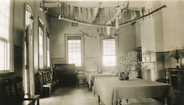
Mayday Hills Mental Hospital was originally constructed in 1864 under the name of the Beechworth Lunatic Asylum. It was built for locals in need of help who were kept in the local gaol. In its first decade, the residents of the hospital were used as menial labourers but over time, as mental healthcare progressed, were cared for in more nuanced ways. This site became a training hospital for nurses in the 1960's. Eventually, mental health patients were moved to other care facilities and Mayday Hills was operating as a geriatric care facility. It was closed in 1995, after which the buildings and their grounds were purchased to La Trobe University to be used as a campus. The university sold the site in 2011 to private ownership. The image depicts an interior room which is presumed to be a dining or common room. This space has been decorated for Christmas.Mayday Hills Mental Hospital is a historically significant site for many factors. It is representative of healthcare practice in nineteenth century Victoria. It contains rare examples of construction and architecture. It is also significant for aesthetic and technical reasons. Black and white rectangular photograph printed on photographic paperObverse: PRINTED BY/ L.MAHER/ BEECHWORTH/ 1997.2702mayday, mayday hills hospital, mayday hills, mayday hills mental asylum, beechworth lunatic asylum, lunatic asylum, beechworth, gaol, beechworth hospital for the insane, beechworth mental hospital, mental hospital, hospital, nurse, nurses quarters, la trobe university, training facility, christmas, christmas party -
 The Beechworth Burke Museum
Photograph, 1930
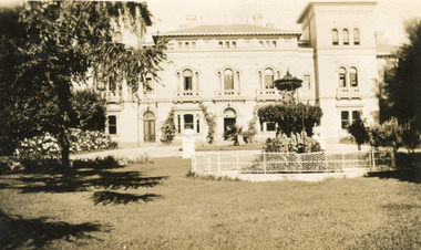
Mayday Hills Mental Hospital was originally constructed in 1864 under the name of the Beechworth Lunatic Asylum. It was built for locals in need of help who were kept in the local gaol. In its first decade, the residents of the hospital were used as menial labourers but over time, as mental healthcare progressed, were cared for in more nuanced ways. This site became a training hospital for nurses in the 1960's. Eventually, mental health patients were moved to other care facilities and Mayday Hills was operating as a geriatric care facility. It was closed in 1995, after which the buildings and their grounds were purchased to La Trobe University to be used as a campus. The university sold the site in 2011 to private ownership. This image depicts the front facade of the building and a portion of the gardens, including a fountain. Mayday Hills Mental Hospital is a historically significant site for many factors. It is representative of healthcare practice in nineteenth century Victoria. It contains rare examples of construction and architecture. It is also significant for aesthetic and technical reasons.Black and white photograph printed on matte photographic paperReverse: Mental Hospital/ Beechworth Lunatic Asylum/ Xmas 1930/ 8190 VELOX (Watermark)mayday, mayday hills hospital, mayday hills, mayday hills mental asylum, beechworth, beechworth asylum, beechworth lunatic asylum, beechworth hospital for the insane, garden, gardens & parks, architecture, historic victorian architecture, healthcare, health, fountain, la trobe university -
 The Beechworth Burke Museum
Postcard, Eda P Beckmann, c1935
Mayday Hills Mental Hospital was originally constructed in 1864 under the name of the Beechworth Lunatic Asylum. It was built for locals in need of help who were kept in the local gaol. In its first decade, the residents of the hospital were used as menial labourers but over time, as mental healthcare progressed, were cared for in more nuanced ways. This site became a training hospital for nurses in the 1960's. Eventually, mental health patients were moved to other care facilities and Mayday Hills was operating as a geriatric care facility. It was closed in 1995, after which the buildings and their grounds were purchased to La Trobe University to be used as a campus. The university sold the site in 2011 to private ownership. This postcard depicts an interior room which is presumed to be a living or reception room. It is filled with period furnishings. Mayday Hills Mental Hospital is a historically significant site for many factors. It is representative of healthcare practice in nineteenth century Victoria. It contains rare examples of construction and architecture. It is also significant for aesthetic and technical reasons.Black and white postcard printed on matte cardReverse: 11.5.35/ Miss Peach/ Best wishes/ from/ P. Beckman mayday, mayday hills hospital, mayday hills, mayday hills mental asylum, mayday hills mental hospital, beechworth, beechworth asylum, beechworth hospital for the insane, beechworth lunatic asylum, lunatic asylum, healthcare, health, living in country towns, living room, furniture, interior -
 Warrnambool and District Historical Society Inc.
Album, Warrnambool and District 1886 Western Hotel, 1886
This album contains a number of local coastal and seascapes including Thunder Point, views of local streets such as Liebig and Fairy streets, panorama views of the town from Manse Hill and Booval Hill and the Botanic Gardens. Buildings included are Cramond and Dickson, St Joseph’s Church, the saleyards. The book itself would have been used by patrons of the Western Hotel when J Fox was licensee, from 1880 until 1887. The hotel had been operating since 1870 when William O’Brien applied for a publican’s license for the house on the corner of Timor and Kepler Streets with five sitting rooms and eight bedrooms. The stone building was designed by Andrew Kerr and built by Williams & Co. The Western Hotel was also the booking office for Cobb and Co Coaches which operated until the railway came to town in 1890. This album has historical significance on different levels. Firstly the photographs provide a view of Warrnambool in the late 19th century. The photos are aesthetically and artistically significant. Many of the buildings in the streetscapes are still recognizable. Secondly the Western Hotel has occupied a prominent site within the CBD for nearly 150 years. It has links to Cobb & Co, an important part of early Australian transport. Large hard covered album. Dark green cover with title in red rectangle on front cover. Text in gold lettering. A variety of photographs mounted on card.Chuck Photo Ballarat on front cover. Small cutting pasted inside front cover, reads as follows,” Will and Estates. Joseph Fox, late of Grosvenor Street, Balaclava who died on 29th July by his will of 11th August 1915 left 3737pounds real estate and 2342 pounds personality to relatives. warrnambool, warrnambool history, warrnambool photographs of the past, western hotel photographs -
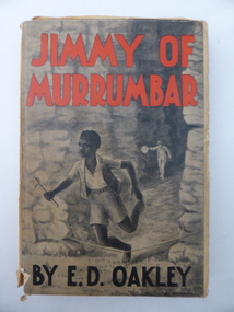 Warrnambool and District Historical Society Inc.
Book, Jimmy of Murrumbar by E D Oakley, 1938
This book subtitled, ‘A Story of the Amazing Ability and Fidelity of an Australian Black Tracker’, has been written in the late 1930s by Edward Daniel Oakley (1877-1962). He was the fourth child of Thomas and Eliza Oakley who had the farm, Oakbank, near the mouth of the Hopkins River, Warrnambool (Otway Road area today). Edward Oakley first worked at Saltau’s shipping office in Warrnambool then ran a dairy farm, Halifax, near Cudgee. He later had wheat farms in the Grampians area and at Willaura before returning to Warrnambool in 1923. He built a row of shops in Liebig Street and opened a boot and shoe store. He was instrumental in persuading Fletcher Jones to open a shop in Warrnambool. After he retired he researched and wrote the story of Jimmy of Murrumbar. This book is of high significance because: 1. It was written by a local Warrnambool businessman, Edward Oakley. He and other members of his family were prominent residents of the city in the late 19th and early to mid 20th centuries 2. It was written in the late 1930s and tells of the story of a young aboriginal boy, one of the early writings appreciating the talents and worth of young aborigines. This is a hard cover book of 181 pages. A buff-coloured dust cover has been pasted over the hard cover and it has a black, grey and white illustration of a young aboriginal boy being chased. This illustration is repeated in black and white on the second page. The titling on the cover is in red and black printing. The front cover has become almost detached from the pages. An inscription on the inside cover is handwritten in black ink. The book has a foreword, an appreciation, a contents page and 23 chapters. ‘Best Wishes for a Happy Birthday from Graeme Dorman Dec 8th 1942’ edward oakley, history of warrnambool, aboriginal literature, jimmy of murrumbar, thomas and eliza oakley -
 Warrnambool and District Historical Society Inc.
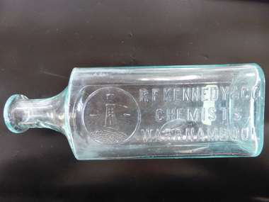
Bottle, R F Kennedy & Son, c. 1900
This bottle was made by Whitall Tatum and Co. of U.S.A. It was used in the pharmacy business of R. F. Kennedy and Co. of Warrnambool and it has the well-known Kennedy symbol of a lighthouse on a rocky face on a coastline with ships in the distance. Richard Frank Kennedy (1826-1903) was born in England and came to Warrnambool in the early 1880s where he quickly established a large pharmacy business in Timor Street. In 1891 he built new premises with the shop described as one of the most elegant and best-stocked chemist’s shops in Victoria. He was a retail, wholesale and manufacturing chemist. Kennedy was active in community affairs in Warrnambool and was a foundation member of the Warrnambool Bowls Club, being the first Vice-President and an early President. The pharmacy business continued after Kennedy’s death, trading as ‘R.F. Kennedy and Co’. Richard Frank Kennedy was one of the most significant businessmen in Warrnambool in the late 19th century. The products of his chemist shop and factory were distributed all over Victoria and beyond. This bottle is a very good example of a Kennedy chemist bottle. This is a clear glass bottle used in the pharmacy of R. F. Kennedy and Co of Warrnambool. The bottle has a rectangular-shaped body with rounded edges, a circular shaped neck and a moulded top that extends over the neck. The top has a piece missing and there is no stopper. The chemist’s logo and name are embossed on the side of the bottle and the maker’s name is on the base of the bottle. ‘R.F.Kennedy & Co, Chemists Warrnambool’ ‘W.T. & Co, U.S.A.’ ‘Pat. Dec 11 1894’ r.f.kennedy,, chemists in warrnambool -
 Warrnambool and District Historical Society Inc.
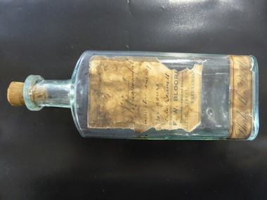
Bottle, F W Bloore, Early 20th century
This bottle was used in the pharmacy of the Warrnambool chemist Francis Bloore. It contained a mixture made up for Archdeacon Thomas Bennett who was the Anglican Vicar of Christ Church, Warrnambool from 1912 to 1915. As Captain Bennett he was the chaplain of the 22nd Battalion in World War One from 1915 to 1917. He became Archdeacon of Warrnambool in 1917 and held this position until 1937. He spent much time on his return assisting returned World War One soldiers and their kin in the Warrnambool area. He was the first President of the Warrnambool Returned Soldiers League. Francis Bloore, born in Ballarat in 1874, came to Warrnambool about 1912. In 1914 he leased a newly-built shop at the corner of Liebig Street and Raglan Parade and continued on the business until the late 1930s. This bottle is of great interest as it is one of the few items we have in our collection associated with the pharmacy business of Francis Bloore. The bottle is also associated with an important Warrnambool Anglican Church identity, Archdeacon Bennett. This is a glass bottle with a rectangular-shaped body with rounded edges, a circular-shaped neck and a circular moulded top with an opening. It has a cork stopper. The top of the bottle is chipped. The label on the front of the bottle is partly torn away and very stained with most of the handwriting and some of the printing indecipherable. The inside of the bottle is discoloured. ‘The Mixture …. tablespoonful with water every three hours - Archdn Bennett’ ‘Shake the Bottle’ ‘F.W. Bloore Pharmaceutical Chemist Liebig Street Warrnambool’ ‘RT & Co’ francis bloore,, warrnambool chemist, archdeacon bennett,, warrnambool anglican minister, history of warrnambool -
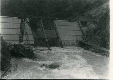 Kiewa Valley Historical Society
Photograph - Kiewa River in flood at Clover Dam
As part of the push to cut electricity costs and diversify supply, the Victorian Government (circa 1930) implemented the conversion strategy from mainly brown coal supply to hydro - electricity. The Kiewa Hydroelectric Scheme became the largest scheme of its kind in the State Of Victoria and the second largest scheme in Australia. Clover Dam and Power Station were built by the State Electricity Commission of Victoria as part of the Kiewa Hydro Electric Scheme from the late 1930's to the early 1940's. This dam was constructed to supply water to feed four turbines (62 mega watts) at the West Kiewa Power Station. This was at the forefront of sustainable "Green" energy. Costs associated with power supplies is still a major incentive of governments, however environmentally friendly alternatives such as wind and nuclear have also made inroads. The Kiewa valley and its surrounding alpine catchment were looked at(Victorian State Government), from the beginning of the twentieth century as a source of alternate power for an ever-increasing demand for electricity by growing population and heavy industrial areas within Melbourne City and State regions. Construction of dams, such as Clover Dam provided the large quantity holding areas of water required to turn the turbines at the various power stations to provide the electricity needed. The impact of these controls by moderating water run-off from the alpine regions is beneficial in reducing flooding from thawing of snow on the alps. This by-product allows agriculture and grazing to be less vulnerable to seasonal flooding thereby resulting in a more stable annual production level.Black and white photograph of Clover Dam with Kiewa River in flood. .5mm white boarder on 3 sides of photo.Handwritten on back of photograph in black pen - Kiewa in flood. Clover Dam.clover dam, secv -
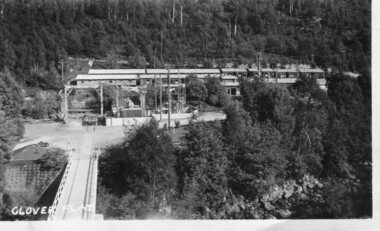 Kiewa Valley Historical Society
Photograph - Clover Dam
As part of the push to cut electricity costs and diversify supply, the Victorian Government (circa 1930) implemented the conversion strategy from mainly brown coal supply to hydro - electricity. The Kiewa Hydroelectric Scheme became the largest scheme of its kind in the State Of Victoria and the second largest scheme in Australia. Clover Dam and Power Station were built by the State Electricity Commission of Victoria as part of the Kiewa Hydro Electric Scheme from the late 1930's to the early 1940's. This dam was constructed to supply water to feed four turbines (62 mega watts) at the West Kiewa Power Station. This was at the forefront of sustainable "Green" energy. Costs associated with power supplies is still a major incentive of governments, however environmentally friendly alternatives such as wind and nuclear have also made inroads. The Kiewa valley and its surrounding alpine catchment were looked at(Victorian State Government), from the beginning of the twentieth century as a source of alternate power for an ever-increasing demand for electricity by growing population and heavy industrial areas within Melbourne City and State regions. Construction of dams, such as Clover Dam provided the large quantity holding areas of water required to turn the turbines at the various power stations to provide the electricity needed. The impact of these controls by moderating water run-off from the alpine regions is beneficial in reducing flooding from thawing of snow on the alps. This by-product allows agriculture and grazing to be less vulnerable to seasonal flooding thereby resulting in a more stable annual production level.Black and white photograph of Clover Dam buildings and Kiewa River. Has a .4cm white border around photograph Printed on bottom left corner of photograph in white - Clover Flatclover dam, secv -
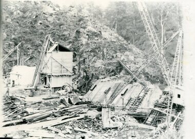 Kiewa Valley Historical Society
Photographs x 2 - Clover Dam, Circa 1940's
As part of the push to cut electricity costs and diversify supply, the Victorian Government (circa 1930) implemented the conversion strategy from mainly brown coal supply to hydro - electricity. The Kiewa Hydroelectric Scheme became the largest scheme of its kind in the State Of Victoria and the second largest scheme in Australia. Clover Dam and Power Station were built by the State Electricity Commission of Victoria as part of the Kiewa Hydro Electric Scheme from the late 1930's to the early 1940's. This dam was constructed to supply water to feed four turbines (62 mega watts) at the West Kiewa Power Station. This was at the forefront of sustainable "Green" energy. Costs associated with power supplies is still a major incentive of governments, however environmentally friendly alternatives such as wind and nuclear have also made inroads. The Kiewa valley and its surrounding alpine catchment were looked at(Victorian State Government), from the beginning of the twentieth century as a source of alternate power for an ever-increasing demand for electricity by growing population and heavy industrial areas within Melbourne City and State regions. Construction of dams, such as Clover Dam provided the large quantity holding areas of water required to turn the turbines at the various power stations to provide the electricity needed. The impact of these controls by moderating water run-off from the alpine regions is beneficial in reducing flooding from thawing of snow on the alps. This by-product allows agriculture and grazing to be less vulnerable to seasonal flooding thereby resulting in a more stable annual production level. Photographs also document early engineering and building techniques used in the construction of dams and power stations during the 1940’s and 1950’s. Note the lack of safety equipment and suitable work attire worn by construction workers on the sites 1. Black and white photograph of Clover Dam under construction. Has a .5cm white border around photo 2. Black and white photograph of Clover Dam under construction showing workmen at work. Has a .5cm white border around photo Written in pencil on back of both photographs - Clover Damclover dam, secv -
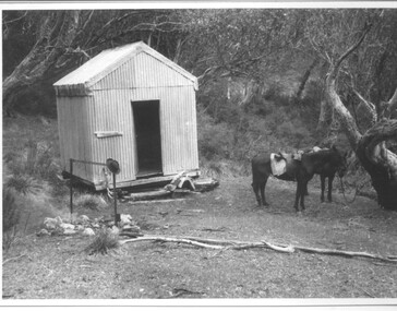 Kiewa Valley Historical Society
Photograph - Photographs x 13 - Cattlemen
11 of the 13 photos were taken by Tor Holth and used in his book "Cattlemen of the High Country" first published in 1980. Co writer was Jane Holth (Barnaby). Of the other two photos, one was taken by C. Roper (2 old gentlemen of the High Plains) and the other (Fred Roper, Tom Hollonds, Kyran Marum - early cattlemen) unknown photographer. The book tells the story of the lives of the mountain cattlemen of Victoria's high country, the harsh conditions and challenges they faced when they mustered their cattle before winter to bring them down to lower pastures. Huts were built of any materials available and were scattered about the high plains to provide shelter from the elements. Some are still standing despite the many bushfires that have ravaged the area.The photographs are of historic significance as they are of early pioneers in the cattle industry in the Kiewa Valley. The huts are of significant interest as they show different types of construction and materials as does the cattle yard at Bogong Jack's. All 13 photos are black and white and printed on photographic paper and are of varying size. 1.On the back, hand written in pencil - "Bogong Jacks hut on Fainter Spur". 2.15 in top right hand corner and 120% centre of photo and circled. 2.On the back a typewritten label cut out and fixed with sticky tape "45 b.&w. Cope Hut, known also as the Menzies of the high plains." Lower left corner is a handwritten label, written in red biro, COPE HUT (underlined) V circled and Journeys into History. 3. Top right hand corner '2.32(a) and across the back, written in pencil, 'Wallace's Hut 1976' and 'TOR HOLTH' in red biro on small sticker lower R corner. 4.2.32(c) in pencil top R corner. 'Wallaces Hut 1976' in pencil across back of photo. 5. '42.7a' in pencil top R corner. Written in pencil across back of photo 'Remains of the second Tawanga Hut.' 6. 'Jim Edmundson Mt. Beauty' handwritten in blue biro across back of photo. 7. '2.26' in pencil top R corner. 'Cattle yard at Bogong Jack's' handwritten in blue biro across back of photo. 8. 'Jim Edmondson of Edmondsons hut' written in pencil on back of photo. 9. 'Geoff Wallace Kergunyah' written in pencil on back of photo. 10.' Geoff Wallace Kergunyah' handwritten in pencil on back of photo. 11. 2.11 in pencil top R corner. 'Fred Roper & Jack Platt. Ph. C.Roper' handwritten in orange pen and under, in pencil, '2 old gentlemen of the High Plains.' 12. Written in black pen across back of photo 'Left to right Fred Roper, Tom Hollonds, Kyran Marum - early cattlemen' 13. Hand written on back of photo 'Sid Ryder' photos, cattlemen, high plains, huts