Showing 22289 items
matching parks
-
 Surrey Hills Historical Society Collection
Photograph, "Ancyra", 25 Weybridge Street, Surrey Hills
John Butler Maling, retired farmer, built his home on the corner of his property which extended from Weybridge Street to Whitehorse Road and from James to Ross Street. From 1853 he lived in a simple farmhouse located near the present Ross Street until he had 'Ancyra' built in c.1889 from bricks made from clay dug from a quarry on the property. This was located in the now-park in James Street. John Butler Maling Snr was born in Shepreth, Cambridgeshire. He married Kate Conlan in 1882 and they had 3 children - Silas, Alick and Zillah. He died in 1912 and is buried in Box Hill Cemetery. Often referred to as John Butler Maling Senior as he had a nephew by the same name. He also lived on a similar sized property known as 'The Willows', located to the west. He became the first Mayor of Camberwell. From c1936 til c1960 the property was used as a rest home (Ancyra Rest Home) and then a nursery (Pied Piper Nursery). This is one of relatively few surviving houses that provides links to pre0urban Surrey Hills. It is also built from locally quarried material.A black and white photograph of a house viewed through the front garden.ancyra, house names, weybridge street, surrey hills, james street, bricks, john butler maling senior, miss kate conlan, mrs kate maling, alick maling, silas maling, zillah maling, ancyra rest home, pied piper nursery, box hill cemetery -
 National Wool Museum
Photograph - Portrait of Joan Lindros, Nicole Marie, 2021
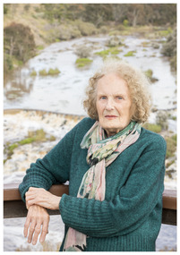
Thousands of volunteers work tirelessly to conserve and protect the environment of Geelong and the Bellarine. Their work often goes unnoticed. In 'The Work of Nature' the National Wool Museum and the Environment Department at the City of Greater Geelong worked with photographer Nicole Marie to showcase the significant contribution of environment volunteers in our region. Each of the eight people showcased in these portraits were nominated by their peers and members of the community for their significant contribution to conserving and protecting the environment. Joan Lindros - Geelong Environment Council Joan Lindros has been a mentor to community environmentalists across the Geelong region and beyond for many years. In 1972 she was a foundation member of the Geelong Environment Council. She was also instrumental in the Save the Otways campaign that resulted in the Great Otway National Park. Joan is an inspirational leader, tenacious advocate and a gentle person. In 2001 she was inducted into the Victorian Honour Role of Women. She continues to be involved in the Friends of Buckley Falls who have been working and advocating for the protection and restoration of the Barwon and Moorabool River Reserves for nearly forty years. Photo at Buckley Falls lookout by Nicole Marie.Image showing an environmental portrait of a woman leaning against wooden railing with trees, a river and a waterfall in the background.environment, conservation, portraits, geelong, nature, exhibition, work of nature, geelong nature forum, volunteers, buckley falls -
 Melbourne Legacy
Letter, (H9), 1937
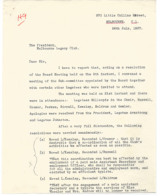
These two letters discuss the secretarial requirements of Legacy in the 1930s. One is a letter to Legatee Os Gawler outlining the costs incurred by the Board of Management General Fund for the past 3 and half years that related to the secretarial fees of Miss Wheeler and stationery and phone expenses. It was written in response to a request by the President. The second letter shows there was a resolution a couple of weeks later that the Board moved to appoint a sub committee. The sub committee consisted of Legatees Gillespie, Russell, Cremor, Parkes, Birrell, Kemsley, Meldrum and Gawler. The sub-committee decided that the co-ordination of the club was best served by a paid male Assistant Secretary and Employment Officer who would be responsible for all the administrative and employment work, assisted by a typist. Also that when that was enacted the services of Miss Wheeler and Mrs Andrews were no longer required. These documents show that the club had recognised the need for paid assistance in their administration. The notation H9 in red pen shows that it was part of the archive project that was trying to capture the history of Legacy. A notation on the back says: 'Appointment of first paid Secretary of Melbourne Legacy'.Very early documents that document the activities of the Legacy club and its expenditure. White quarto letter with black type x 2 pages about secretarial requirements and letter about expenses of Legacy Club written in 1937 x 5 pages.Handwritten H9 in red pen. 01482.1 some pencil notations and signed James G Gillespie in fountain pen. 01482.2 has underlining of dates and figures in red pen and signed ? Wallace Hon. Treasurer.history, organisation structure -
 Melbourne Legacy
Document - Report, 81st Highlights Report from the President 2004, 2004
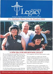
The highlights report in 2004 was published as the 81st report from the President. George MacKenzie was the incoming president to replace Geoff Ward. Ron Barassi promoted the 2004 Badge Appeal which achieved a record figure of $411,500. He had included a trip to Werribee Park Zoo and was photographed with the lions (see item 00. Up to the 1980s the annual report would usually contain pages containing the Presidents report and photos of significant events of the year. Between 1987 and 1990 these were published in a separate document called 'Highlights from the Annual Report'. This could be used in promoting Legacy in different ways, without all the financial information normally held in an annual report. In following years it became called 'Report from the President' then 'Highlights from the President' in 2004, before becoming 'Melbourne Legacy Highlights' which was published twice a year from 2007. It was eventually renamed, 'The Torch, Melbourne Legacy Highlights' in 2012. 'The Torch' is still published twice a year. Other annual reports in 00027, 01095, 01096 and 01097, 01098, 01310 and 01311. A record of the annual reports of Legacy Melbourne, including activities and telling stories of Legacy's impact.Colour printed president's report from 2004 x 8 pages with photos, published annually.annual summary, activities -
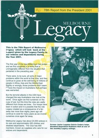 Melbourne Legacy
Document - Report, 78th Report from the President 2001, 2001
In 2003 David Grierson was the president and was about to hand over to Tony Parkes. His report shows pictures from many of the activities the widows are involved in such as exercise classes, walks and the preparation of rosemary sprigs for Anzac Day. The report also recaps events through the year such as outings and camps for the junior legatees, legacy week and the public speaking contest. Up to the 1980s the annual report would usually contain pages containing the Presidents report and photos of significant events of the year. Between 1987 and 1990 these were published in a separate document called 'Highlights from the Annual Report'. This could be used in promoting Legacy in different ways, without all the financial information normally held in an annual report. In following years it became called 'Report from the President' then 'Highlights from the President', before becoming 'Melbourne Legacy Highlights' which was published twice a year from 2007. It was eventually renamed, 'The Torch, Melbourne Legacy Highlights' in 2012. 'The Torch' is still published twice a year. Other annual reports in 00027, 01095, 01096 and 01097, 01098, 01310 and 01311. A record of the annual reports of Legacy Melbourne, including activities and telling stories of Legacy's impact.Colour printed president's report from 2001 x 8 pages, with photos.annual summary, activities -
 Melbourne Legacy
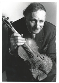
Photograph, The Changi Violin
A photo of Sir Edward 'Weary' Dunlop holding the violin that is part of Melbourne Legacy's collection (see 00080). Unsure when this photo was taken. Background: This violin was played by VX30301 Dvr Roy Arnel, as a member of the Australian Imperial Force Concert Party, in the Changi POW camp, Singapore from 1942-1945. It is claimed that the violin, in its case was thrown over the wall by a Chinese civilian. Roy Arnel, a South African by birth enlisted on 7 June 1940 at Royal Park, Melbourne and served with 2 AASC Company as a driver. He was captured by the Japanese Imperial Army at the fall of Singapore in February 1942. There was more than one concert party in Changi as indicated on the rear of the violin. The details of the Dutch, British and American Concert Parties scratched in to the varnish. There are some well-known names scratched into the violin including: The English author and cartoonist, Ronald Searle; Australian entertainer, Frank Rich; and Australian Author, Russell Braddon Mr Arnel died in 1982 and the violin was presented to Melbourne Legacy for preservation, safe keeping and display.A record of relationship of Weary Dunlop with Legacy.Black and white photo of Sir Weary Dunlop with the Changi violinchangi violin, dunlop -
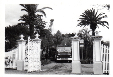
 Eltham District Historical Society Inc
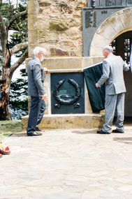
Photograph, Governor Landy with assistance from Harry Gilham unveils the Korea-Borneo plaque, Rededication Ceremony, War Memorial Tower, Kangaroo Ground, 08 November 2011
Victorian State Governor John Landy AC, MBE, re-dedicates the 75-year-old Memorial Tower of Remembrance at Kangaroo Ground with the unveiling of the cast bronze plaques which recognize the Australian participation in the Armed Conflicts of Korea 1950-1953, Borneo 1962-1966, Malaya 1948-1960, and Vietnam 1962-1973 - on the memorial's 75th anniversary to those who served in Armed Conflicts between 1948 and 1972. Harry Gillham, President of EDHS and Convenor of the Nillumbik Shire Council's Advisory Committee for the War memorial at Kangaroo Ground was for some years working on the refurbishment of the Tower of Rememberance and the surrounding park. The Committee decided to produce plaques to commemorate the armed conflicts in Korea, Malaysia, Borneo and Vietnam. The plaques were funded by public donations and cost $10,000. The community donated via donation boxes placed at Eltham Library. NL 140 Sept 2001 Governor John landy and other digniaries attended the event for the unveiling of the plaque. Gov Landy unveiled the plaque which was attached to the historical tower in November 2001. Colour photographkangaroo ground, war memorial tower, rededication ceremony, governor of victoria, john landy, harry gilham -
 Melbourne Tram Museum
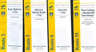
Ephemera - Timetable - The Met - set of 13, The Met, 1996
Set of 13 The Met timetables, with an image of the relevant depot manager, details of hiring a tram, The Met fare system, and a diagrammatic map. All are revised issues of earlier timetables and dated Feb. 1996 unless noted otherwise. 1 - Route 3 - East Malvern - City 2 - Route 5 - Malvern Burke Road - City 3 - Route 6 - Glen Iris - City 4 - Route 55 - West Coburg - Domain Interchange 5 - Route 57 - West Maribyrnong - City 6 - Route 59 - Airport West - City 7 - Route 69 - Kew Cotham Road - St Kilda Beach 8 - Route 70 - Wattle Park - Princes Bridge 9 - Route 72 - Camberwell - Melbourne Uni - Dec. 1996 10 - Route 78, 79, North Richmond - St Kilda Beach or Prahran 11 - Route 82 - Moonee Ponds - Footscray 12 - Route 96 - St Kilda Beach - East Brunswick 13 - Route 34 - La Trobe St Services - includes routes that served La Trobe St.Yields information about some of The Met tram services Feb. 1996Set of 13 The Met timetables, DL size, printed in two colours.timetables, the met, route 3, route 5, route 6, route 55, rout 57, route 59, route 69, route 70, route 72, route 78, route 79, route 82, route 96, route 34, la trobe st -
 Bendigo Military Museum
Photograph - Annual Sport Competition: Flag Day - Army Survey Regiment Verses School of Military Survey, Bendigo, 1977
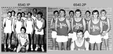
This set of 33 photographs of sports action was taken on Flag Day, an annual sports competition between the Army Survey Regiment (ASR) and the School of Military Survey (SMS), at Bendigo on the 13th of May 1977. Softball was held at Beischer Park Strathdale, sailing was most likely held at Lake Eppalock, rifle shooting at Wellsford Rifle Range and tug-of-war at Fortuna. The venues for basketball, golf, squash and volleyball are unknown. The two RA Svy units took turns each year to host the event. Personnel from the ASR’s Detachment located at Bonegilla were part of the SMS’s teams. The day competition usually comprised basketball, cross country, golf, sailing, squash softball, tennis, rifle shooting, touch football, tug-of-war and volleyball. The evening competition often included darts, carpet bowls, hookey, quoits and snooker. See items 6025.15P for photo proofs of sports action and 6326.25P for softball action and taken on the day. There are numerous duplicates previously published from these photo proofs; however they are inferior in quality.This is a set of 33 photographs of sports action was taken on Flag Day, Army Survey Regiment (ASR) versus the School of Military Survey (SMS), at Bendigo on the 13th of May 1977. The photographs were printed on photographic paper and are part of the Army Survey Regiment’s Collection. The black and white photographs were scanned at 300 dpi. .1) - Photo, black & white, 1977, Basketball. ASR Team Back row L to R: unidentified, Stuart Symonds, Bruce Gordon. Front row L to R: unidentified (x2), Bill Jones, unidentified. Sitting: unidentified. .2) - Photo, black & white, 1977, Basketball. SMS Team Back row L to R: Duncan Burns, Stuart Thaxter, unidentified (x2). Front row L to R: Owen Moss, unidentified, Steve Hansen. Sitting: unidentified. .3) to .5) - Photo, black & white, 1977. Basketball action. .6) - Photo, black & white, 1977, Golf - L to R: Kevin ‘Chuck’ Berry, George Austen, unidentified, Roy Morgan. .7) - Photo, black & white, 1977, Golf - L to R: Stan Vote, Gordon Lowery, Peter Warwick, John ‘JB’ Barrie. .8) & .9) - Photo, black & white, 1977, ASR Golf Team – Back row L to R: Peter Warwick, unidentified, Graeme Jeffers, John Sinclair. Front row L to R: Stan Vote, Roy Morgan, George Austen, Len Thirlwell. .10) & .11) - Photo, black & white, 1977, SMS Golf Team - Back row L to R: Kevin ‘Chuck’ Berry, unidentified, Gordon Lowery. Front row L to R: unidentified, Peter Hardy, unidentified, John ‘JB’ Barrie. .12) & .13) - Photo, black & white, 1977, Golf. Teeing off – unidentified. .14) - Photo, black & white, 1977, Golf. Teeing off – John Sinclair. .15) - Photo, black & white, 1977, Golf. Putting – Stan Vote. .16) - Photo, black & white, 1977, Golf. Putting - Peter Warwick. .17) - Photo, black & white, 1977, Golf. Putting – Roy Morgan. .18) - Photo, black & white, 1977, ASR Rifle Shooting Team - Back row L to R: Paul Davis, unidentified (x2), Max Neil, Rhys De Laine. Front row L to R: Tony Lawler, Rene van den Tol, unidentified, Warren ‘Waldo’ Shirley. .19) - Photo, black & white, 1977, ASR Rifle Shooting Team – L to R: unidentified (x4), 2nd back right: Tony Lawler, unidentified. .20) - Photo, black & white, 1977, SMS Rifle Shooting Team - Back row L to R: John Ashby, unidentified (x3). Front row L to R: Dave Murphy, Wolfgang Thun, John ‘Stormy’ Tempest, unidentified. .21) - Photo, black & white, 1977, Softball – L to R: Jenny Haddow, Debbie Brown, unidentified umpire. .22) - Photo, black & white, 1977, ASR & SMS Sailing Teams – Back row L to R: Chris Osborne, Josh De Groot, unidentified (x2), Greg Francis-Wright, Peter Breukel. 3rd row L to R: Marrianne (Van De Zee) De Groot, unidentified, Kim Reynolds, Alex Cairney, unidentified, Sam Chambers. 2nd row L to R: Les Dixon, Jim Macdonald, unidentified, George Graham, Ted ‘FOT’ Burgess. Front row L to R: Doug Carswell, Alan Adsett, Peter Mustart, Tony Waldon, Dave Miles. .23) - Photo, black & white, 1977, Sailing on Lake Eppalock, Victoria. .24) - Photo, black & white, 1977, SMS Squash Team – Back row L to R: Graham Squire, Peter Constantine AM, Peter Colwell, Bill Boyd OAM, Front row L to R: unidentified, Dick Barwald, Colin Darch, unidentified. .25) - Photo, black & white, 1977, ASR Squash Team – Back row L to R: Andy Wilson, Terry Danger, Errol Fletcher, Dennis Puniard. Front row L to R: Lynn Johnson, Kerry Browne. .26) - Photo, black & white, 1977, ASR Tug-of-War Team: Back row L to R: Russ Mollenhauer, Neville Stone, Jim Cook, Jeff Willey, unidentified (x3). Front row L to R: unidentified, John ‘Flash’ Anderson, Mick ‘Buddha’ Ellis, Ken ‘Sluggo’ Slater, Rob ‘Boges’ Bogumil, Frank Lenane, unidentified. .27) - Photo, black & white, 1977, SMS Tug-of-War Team: Back row L to R: unidentified, Stuart Thaxter, Steve Hansen, unidentified (x2). Front row L to R: Kim Lenson, unidentified (x4), Jamie ‘Fish’ McRae. .28) & .29) - Photo, black & white, 1977, ASR Tug-of-War Team in action. .30) - Photo, black & white, 1977, Volleyball action. .31) - Photo, black & white, 1977, Volleyball action. Chris Edwards blocking. .32) & .33) - Photo, black & white, 1977, Volleyball action..1P to .33P –No personnel are identified. ‘Regiment v School 13 May 1977’ annotated on cover sleeve.royal australian survey corps, rasvy, army survey regiment, army svy regt, fortuna, asr, school of military survey, flag day -
 Narre Warren and District Family History Group
Book, Oscar Wanke, Oscar Wanke Diary 1909, 1909
Oscar Wanke was born in Harkaway on 18 July 1887. His parents, Immanuel and Bertha nee Aurisch owned Hillcroft on Hessel Road. Oscar was the 7th child of 15. Four of the children died in childhood. Oscar married Minna Ida Weist on 13 February 1913 in Dandenong. Her parents were Charles and Ida Weist and lived on a property in Police Paddocks on Gladstone Road. Minna’s father gave the couple land on the corner of Gladstone & Heatherton Roads as a wedding present and Oscar built their house, which is still standing, now heritage listed. They had enough land to keep a horse and cow, have a large workshop, garden, greenhouse and grew vegetables and fruit. Two children were born, Ronald Leslie in 1915 and Evelyn Adelaide in 1919. Oscar Wanke and Walter Brown became partners as builders around the area. The built many houses, the Noble Park Hall and a church in Bangholme. Oscar also designed the plans and working drawings. He also built beautiful furniture. We have his diaries from 1907 to 1926.Saddle stitched (4 staples) paperboard covers, one week to a page with pink blotting papers.oscar wanke, harkaway (vic.) -
 Old Colonists' Association of Ballarat Inc.
Photograph - Image, The History of Charles Anderson and Charles Anderson Grove, Ballarat
Information relating to Charles Anderson and Charles Anderson Grove, Lake Gardens, Ballarat. The Old Colonists' Association Ballarat Inc. is a not for profit charitable organisation providing accommodation for elderly people. It manages a 27 Home retirement village at Charles Anderson Grove, Ballarat. Accommodation is offered at significantly below market rates. It has been providing low cost accommodation to the elderly since the 1920s. The Association Council overseas the running of this facility on a voluntary basis. HISTORY OF THE BALLARAT OLD COLONISTS' ASSOCIATION HOMES AT CHARLES ANDERSON GROVE, LAKE GARDENS One of the original objectives of the Association was “to provide the shelter of a house for those Pioneers of the Goldfields whom the reverses of fortune have deprived of the means of procuring the comforts of life in their declining years.” While the first home at Charles Anderson Grove was built in 1925 the Association had previously provided relief for needy pioneers from the time it was formed in 1883. Relief included monthly monetary payments, loads of firewood, medical assistance and distribution of Christmas boxes of groceries to deserving pensioners and in some cases payment of burial costs. Records indicate that in September 1922 three of the pensioners being assisted by the Association were accepted as residents in the newly erected Hassell Homes in Gillies Street (now demolished-opposite the High School). The first site for an Asylum for Indigent Members of the Old Colonists' Association was temporarily reserved from sale in October 1891. The site was approximately 28 acres in area in Mt Clear nearly opposite Midvale Shopping Centre in Main Road. The site was heavily timbered and when cleared over 260 tons of wood was sold to the Woah Hawp Gold Mining Company. A set of gates were erected but no homes built, although a plan for this reserve was drawn which showed twenty buildings ranging from one to four unit per building. The reserve was revoked in November 1909. The second site temporarily reserved in November 1909 as an Asylum was in Alfredton and consisted of some 7 acres and was adjacent to land reserved for an Abattoirs for the Ballarat Council. The reserve was revoked in February 1912 as it was deemed more appropriate to be added to the Abattoir site. Council suggested four (4) other sites in exchange for this land and they were inspected by the President, Vice President and Secretary on 22 December 1912. The first site inspected was land on the west side of Creswick Road opposite the brick kilns (now occupied by the showgrounds and oval). The land was described as being good quality, well fenced, no trees, good drainage and ample acreage but some distance from trams. The second site was Perry Park which was described as being good land, well fenced, having frontage to Gillies Street, good drainage and about 26 acres (but subsequently reduced to 10 acres). It was closely planted with Pinus Insignias and Wattle and had easy access from the Botanic Gardens tram. The third site was the North West portion of Victoria Park (corner of Sturt and Gillies Street) and was described as good land, well fenced and drained and well located. The fourth site was the South West corner of Victoria Park and known as Pound Paddock (corner of Winter Street and Gillies Street). It was considered to be low lying and too close to the Abattoir, and was also a considerable distance from trams. While the third site was recommended as the most suitable for the erection of homes it was considered unwise from the point of view as citizens to reduce the acreage of the park and therefore it was recommended that the Perry Park site be asked for as the most acceptable to the Association for the building of homes. The site was eventually temporarily reserved for an Asylum for Indigent Members of the Association in April 1914 with the gates from Mt Clear having been removed to the site a year earlier and eventually erected in 1917 for £12.10.0. In the same year the first 290 pine trees were advertised for removal in July and sold for £16. A sign indicating that the site was reserved for the erection of cottages was erected in September 1917. Stripping of the wattle bark (for tanning) and the cutting of the wood occurred in November 1918 with the land then being leased until it was required for the construction of the first homes in 1924. While the site was the third to be reserved it was the only one which was used for its intended purpose. It was named as Charles Anderson Grove in honour of Charles Anderson who joined the Association in 1918 and was President of the Association from 1942 to 1944. CHARLES HENRY GRATTAN ANDERSON C.H.G. Anderson (Electoral Returning Officer) was elected to membership of the Old Colonists' Association, Ballarat, in October 1918. He was elected to the Association Committee in 1926, and appointed Treasurer of the Association on the resignation of F. Ellis until the end of the financial year in 1933. In 1936 Charles Anderson indicated he would not be available for the President's Chair and that he would retire from the Committee owing to pressure of work. C.H.G. Anderson was welcomed as a new member of the Association in 1938, and served as President of the Old Colonists' Association from 1942-1944. Midway through 1949 Charles Anderson was appointed Members Secretary and Manager of the Ballarat Old Colonists' Club at £5.0.0 per week and 10/- for entertainment, to commence work prior to 01 August 1949. He was to do 30 hours per week and be present on Friday and generally on Saturday nights. In 1957 a minute of sympathy was extended to Club Manager Charles Anderson on the loss of his son. In 1958 a bonus of £20.0.0 was paid to Charles Anderson in recognition of his service in assisting the Secretary/Manager taking over under difficult conditions. In March 1964 the Shire of Ballarat would not permit a private road to be named Anderson Grove as Anderson Street already existed in Ballarat but Charles Anderson Grove was deemed acceptable. A recommendation of the Committee was put to the AGM in 1967 that Charles Anderson be made a Life Member. In 1969 an Association meeting observed a minutes silence in memory of Chas Anderson. Charles Anderson was also a Committee member of Ballarat Mechanics' Institute from February 1940 to February 1970. He was President in 1948. Black and white photographic portrait of Charles Anderson.charles anderson, charles anderson grove, ballarat old colonists' club, old colonists' association, ballarat, ballarat mechanics' institute, hassell homes, woah hawp gold mining company, firewood, retirement village -
 Bendigo Historical Society Inc.
Document - PRESENTATION TO BHS 7TH JULY 2000: ''CAMP RESERVE'', 7th July 2000
Presentation by James Lerk to BHS 7th July 2000: ''Camp Reserve -Rosalind Park, used and abused''. First line: ''This short paper has no pretension in giving a complete synopsis regarding a slice of land which cradles a great deal of the history of Bendigo''. References to Commissioner Gilbert; Bank of Victoria; Bendigo Bank; powder magazine; post office; Survey Office; Court of Petty Sessions; Police Barracks; Supreme Court; Gaol; Temperance Society; Robert Strickland residence; tenements on Reserve; Mac's Track; Orderly Room; Cascades; Corporate High School; Temperance Fire Brigade; Masonic Hall; Central School Camp Hill; Fernery; ''The Willows''; Conservatory; Parade Ground; Sandhurst Club; Police Station; Grandstand in Upper Reserve; High School; Soldiers Memorial Insitutute; Lookout (poppet head - Garden Gully United); Advance Bendigo and North League crèche; Sound Shell; Olympic Swimming Pool. Two printed copies.James Lerk.bendigo, streetscape, camp reserve, rosalind park, bendigo creek -
 Southern Sherbrooke Historical Society Inc.
Photograph - The Hermons at the Pakenham Show, c.1965, with their fuel tanker
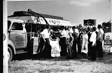
B&W photo showing a group of people watching John and Bill Hermon displaying their fuel tanker at Pakenham Show, c.1965. Photo shows a fuel tanker parked on grass. On the passenger side door is written “W.J. HERMON/71 LONSDALE ST./DANDENONG/Phone 2-1709/AGENT FOR/AMOCO/PETROLEUM PRODUCTS”. John Hermon, in shirtsleeves and trousers, is leaning against the truck, watching his father, Bill, similarly dressed and with a tie, demonstrating what appears to be a gauge on the truck. “AMOCO” is painted twice on the truck. Between the two men is a sign on the ground and leaning against the truck. It reads “[illegible] deliveries to your/storage tank/ensures/you get every/drop you pay for”. A group of approximately seven men, two women and a boy about 10yo are watching. The women and two of the men are wearing sunglasses. A tank with “AMOCO” is behind the truck and on the right of the photo, behind the crowd, is a sign which says “AMOCO/Farm Fuels/FINAL/FILTER” -
 Ballarat Tramway Museum
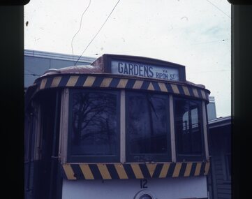
Slide - 27 mm sq slide/s - destination roll, Lilian Butler, Sep. 1971
Yields information about the destination rolls and the locations shown on a roll on a Ballarat Tram.Set of 22 Colour 27 x 27 mm slide in Agfachrome blue and white plastic mounts showing various destinations on tram No. 12 parked on the depot fan. .1 - Gardens via Ripon St .2 - Grey St Sebastl (Sebastopol) .3 - Sebastopol .4 - City .5 - Victoria St .6 - Gardens via Sturt St West .7 - Mt Pleasant .8 - Depot .9 - Bell St .10 - Haddon St via Drummond Nth .11 - Depot via Drummond Nth .12 - City Oval .13 - Special .14 - Gardens via Drummond Nth .15 - View Point .16 - Gregory St .17 - Drummond St Nth .18 - Rubicon St .19 - Depot via Ripon St .20 - Grey St Sebastopol .21 -Sturt St West .22 - Special (Depot - on tram 32 with an "Pay as you Enter" inside the depot building. Photo from the collection of Lilian Butler. ballarat, tramways, trams, depot, sec depot, destination indicators, destination roll, tram 12, tram 32 -
 Ballarat Tramway Museum
Photograph - Leaf from a photo album, 1920s
Leaf from a photo album containing 4 black and white photographs pasted onto sheet of brown/grey cardboard with two punch holes at one end. Photos taken early 1920's or just after construction of the Memorial Arch. Photo 1 - "Ballarat" handwritten in pencil at top - Town Hall from the North West taken from a building near Doveton St. Has a Sebastopol tram west bound in Sturt St. passing Town Hall. Photo 2 - "Sturt Street Ballarat" handwritten in pencil at base - Sturt St. Ballarat looking east from most likely the Ballarat City fire station lookout tower. Has a Sebastopol tram travelling eastbound in the photograph. Town Hall in background. No motor vehicles in photograph. Photo 3 - "Memorial Arch, Ballarat" handwritten in pencil at top - photo of the new Memorial Arch at the start of the Avenue of Honour. Photo 4 - "Eureka Stockade, Ballarat" - photo of the Eureka Stockade monument the park.trams, tramways, ballarat, sturt st, memorial arch - avenue of honour, eureka -
 Kew Historical Society Inc
Archive (Sub-series) - Subject File, Buildings (Kew), 1964
Various partiesReference, Research, InformationSecondary Values (KHS Imposed Order)Subject file containing newspaper articles/clippings, research and correspondence from and to the Society. The earliest item, dating from 1964 is a letter from the Society to the City of Kew seeking Council support for the use of Ellesmore, 80 Princess Street as a cultural heritage centre. Other items of correspondence relate to the Masonic Hall (Walpole Street), Fernhurst, Southesk, Roberts House, Park Hill, Butleigh Wooton, Villa Alba, D’Estaville, Charleville, Roseneath, Merridale, La Verna, Otira, Raheen, Willsmere, Holy Trinity Church. Some of these letters contain information about construction of the buildings and architects. In addition to this correspondence, the file includes brief undated research notes on the Clock Tower at the Kew Cemetery, Tarring, Southesk, the Alexandra Gardens, Studley House (Burke Hall), Ellesmore, the Masonic Hall, Xavier College, Genazzano, Trinity Grammar, Carey Baptist College, Abbotsford, Fernhurst, Illapa, Madford, Morganville, Otira, Parkhill, Monnington, Field Place, Lalla Rookh, Merridale, Kew Mental Hospital, and D’Estaville.buildings -- kew (vic.), heritage -- kew (vic.)buildings -- kew (vic.), heritage -- kew (vic.) -
 Kew Historical Society Inc
Plan - Subdivision Plan, Raheen Estate Subdivision, 1960
Subdivision plans are historically important documents used as evidence of the growth of suburbs in Australia. They frequently provide information about when the land was sold on which a built structure was subsequently constructed as well as evidence relating to surveyors and real estate and financial agents. The numerous subdivision plans in the Kew Historical Society's collection represent working documents, ranging from the initial sketches made in planning a subdivision to printed plans on which auctioneers or agents listed the prices for which individual lots were sold. In a number of cases, the reverse of a subdivision plan in the collection includes a photograph of a house that was also for sale by the agent. These photographs provide significant heritage information relating house design and decoration, fencing and household gardens.The Raheen Estate Subdivision of 1960 involved the creation of 36 residential allotments and the sale of 34 of these. The land on which the subdivision was created had until 1960 formed part of the grounds of the mansion Raheen in Studley Park Road. In 1917, the Catholic Church had purchased Raheen and its lands. It was to become the home of Archbishop of Melbourne, Daniel Mannix, for 46 years. The sale of the subdivision took place three years before the Archbishop’s death. Subsequent archbishops were to reside at Raheen until its sale to the Pratt family in 1981. When the sale of the Estate was reported in the newspapers in 1960, it was described as the last big subdivision near Melbourne. At the auction, 33 of the 36 allotments were sold. The auction realised £315,750. Purchasers were advised that the vendor intended to keep lots 22 and 23. The alllotments in the subdivision required the construction of new roads. These included Eamon Court and Raheen Drive. The justification provided by the Church for the sale was that the estate was being sold to finance school building projects.subdivision plans - kew, studley park, raheen estate, eamon court, studley park road, coombes avenue, raheen drive -
 Bendigo Historical Society Inc.
Newspaper - THE ADVERTISER: FRIDAY JULY 3, 2009 HISTORY-EVENTS THAT SHAPED BENDIGO 32 PAGES, 1881
Headline Moments of the Past The Advertiser, Friday July 3, 2009 History - Events That Shaped Bendigo 32 Page Supplement. Newspaper supplement includes images and articles as diverse as the construction of Alexander Fountain in 1881, The Great Depression 1930s, End of World War II 1945, CBD Floods 1949, Queen Elizabeth's Visit 1954, Olympic Games (Melb) and first television in Bendigo 1956, Bendigo farewells local champion horse 1958, Demolition of verandahs on local buildings 1960s, opening of Eppalock 1964, The Vietnam War 1965-1975, The new dragon Sun Loong 1970, The last tram run and Faraday kidnapping 1972, opening of Sacred Heart Cathedral 1977, opening of Hargreaves Mall 1982, Killians Walk Fire and Gaol Siege 1987, Local government Amalgamation 1993, Opening of Marketplace and Discovery Centre 1995, Restoration of Rosalind Park Cascades 1997, Bendigo Tornado 2003. This publication has not been scanned.bendigo, history, bendigo advertiser, alexander fountain construction 1881, bendigo cbd floods 1949, dmolitition of bendigo building verandahs 1960s, last tram run 1972, killians walk fire 1987, bendigo tornado 2003 -
 Melbourne Tram Museum
Slide - Set of 4, Vic Solomons, Jun. 1970
Slide - set of 4 - 35mm - Kodachrome cardboard mounts. .1 - Tram 808 at the Spencer St stop at the corner of Bourke St with Spencer St Station in the background. Note the route and destination - at the time when North Balwyn and Burwood Routes were combined on Sundays am and evening - and passengers changed at Hawthorn Bridge. Route 74. Has a Fosters Lager advertisement. .2 - As above, tram approaching the stop with the Spencer St station car park in the background. .3 - tram 1005 leaving the Bourke St terminus, taken after .4 .4 - tram 1005 at the Bourke St terminus with tram 838 crossing in the background, has the Station building, Carlyon's Hotel and the Tramways Building. Note the Bundy clock, tram stop signage and safety zone. Route 96. The grey box by the Bundy Clock is thought to be a correspondence box for the satchels that were transported between the depots and head office. Photographed by Vic Solomons June 1970 (based on date stamped on slide)trams, tramways, bourke st, spencer st, railways, stations, route 74, north balwyn, burwood, route 96, letters, mails, tram 808, tram 1005, tram 838 -
 Melbourne Tram Museum
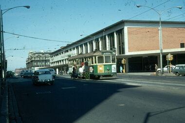
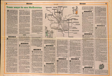
Newspaper, The Age, "Tram ways to see Melbourne", 8/5/1981
Newspaper clipping, from The Age, Weekender, Friday 8/5/1981 titled "Tram ways to see Melbourne", with a number of writers giving a short piece on a particular line. Has a Map of the Melbourne system with destination and route numbers. Has an introduction written by Phillipa Hawker which looks at the history, its place in Melbourne, and possibilities for the future. Written just before the MTA came into existence. Items: East Malvern, Route 3, Rebecca Batties West Preston Route 10, Phillipa Hawker St Kilda, Route 12, Frank Prain North Balwyn, route 48, Andrew Bolt West Maribyrnong route 57, Rosslyn Beeby Essendon Airport, Route 59, Rosslyn Beeby Carnegie, Route 67, Andrew Bolt Kew Cotham Rd, route 69, Andrew Bolt Wattle Park, route 70, Rosslyn Beeby East Burwood, route 75, Rosslyn Beeby East Preston, route 88, Deborah Forster Has some sketches of trams and people.trams, tramways, melbourne, people and places, tourism, east malvern, west preston, st kilda, north balwyn, west maribyrnong, essendon airport, carnegie, kew- cotham rd, wattle park, east burwood, east preston, route 3, route 10, route 12, route 48, route 57, route 59, route 67, route 69, route 70, route 75, route 88, maps -
 Melbourne Tram Museum
Poster, Public Transport Corporation (PTC), "Public Transport Corporation - Your travel made easy", late 1990s
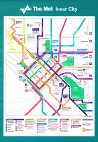
Set of six large posters, featuring the tram map of Melbourne, Inner City, Northern and Southern sections. Items .1 to .3 have an adhesive backing for application onto a tramcar advertising rack. Items .4 to .6 are photocopies of the same with corrections or suggested changes, all c1990. .1 - Inner City - approx. A3, Has the revised The Met symbol with a key along the lower edge detailing route numbers and routes. .2 - Southern Region Tram Map with a map key showing hospitals, points of interest, parks and gardens, some schools and zones. Also shows trams routes through the city, rail lines, stations and major roads with bus routes. .3 - ditto for the Northern Region .4 - Photocopy of the Inner City area with corrections which have been picked up on the final version. .5 - ditto for the Southern Region, two sheets joined together with tape. .6 - ditto for the Northern Region. Items .4 to .6 not scanned.trams, tramways, ptc, posters, trams, the met, map, tram routes, bus routes, route numbers -
 Melbourne Tram Museum
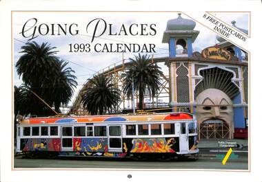
Ephemera - Calendar, Public Transport Corporation (PTC), "Going Places - 1993 Calendar", 1993
Calendar - 16 pages - card cover, full colour, titled "Going Places - 1993 Calendar", published by the Public Transport Corporation featuring public transport photos and 8 postcards in the centre - perforated. Tramway items imaged along with a note about the photograph itself. image 1 - cover 2 and 3 - February - St Kilda Rd From the BP Building, looking north at Dawn 4 and 5 - April - B2 2038 outside the Princess theatre in Spring / Nicholson St 6 and 7 - June - Y 469 as "The Melbourne Tram" with Flinders St in the background. 8 - Postcards - W1 421 decorated for the Royal visit of , Flinders St station with cable and electric trams, Spirit of Progress on Test and the line up of Double deck buses at North Fitzroy. 9 and 10 - August - B2042 in the Bourke St Mall 11 and 12 - October - W5 816 as the Leunig Tram with Luna Park behind. 13 and 14 - December - W2 442 as the Restaurant tram with the Arts Centre behindtrams, tramways, ptc, y class, tourist trams, b class, restaurant tram, st kilda road, transporting art, flinders st station, double deck buses, bourke st, spring st, tram 462, tram 816, tram 2042, tram 442, tram 421, tram 2038 -
 Bendigo Historical Society Inc.
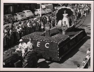
Photograph - HANRO COLLECTION: A COLLECTION OF STREET EASTER PARADE PHOTOGRAPHS
BHS CollectionA Collection of Street Parade Photographs: Three photos all black and white. The first is of the S.E.C. float with *The Magic Servant* being pulled by a tractor with two men aboard. The float is of grass and flowers. Three children are on the float holding signs of Heat, Power, ?. A girl stands in a decorative shell. The street scene is lined with many people and cars of the day are parked at the road edge. The second is of the White Christmas Golden Square Mothers Club. A truck is decorated with a large Christmas tree with children dressed for winter. At the right is a sign*Bendigo Olympic Pool Fun is now open* on the balcony with a crowd of people. The streets are lined with spectators with flags flying above the parade. The Third is a float carrying a train with VR in flowers on the side and a floral display on the float. A crown of flowers at the front and the train on rails is featured. The train is No: B60 and is named the *Harold W. Clapp* All photos are of Bendigo's streetscape. All three photo's have two holes 7.4cm apart for housing in a folder. Box 116Aphotograph, streetscape, bendigo, bendigo. parade. golden square mothers club. -
 Glen Eira City Council History and Heritage Collection
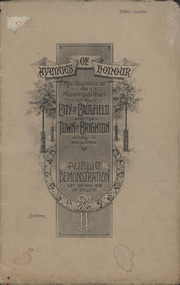
Booklet, D. W. Paterson Co. Pty. Ltd, "AVENUES OF HONOUR The Councils of the Municipalities of the CITY OF CAULFIELD TOWN OF BRIGHTON acting in conjunction PUBLIC DEMONSTRATION SAT 3rd AUG. 1918 AT 3oCLOCK SOUVENIR"
Souvenir Programme from the Councils of the Municipalities of the City of Caulfield and the Town of Brighton for a Public Demonstration to be held on Sat 3rd August 1918 at 3 o'clock for the proposed Avenues of Honour to be planted in memory of fallen WWI soldiers. One of two known copies, this copy has "Town Clerk" stamped in the upper corner, rhs.Commemorative booklet, grey cover with text printed on the grey textured paper and an image of four trees and a wreath. Image of a kookaburra on the back. Inside, 28 numbered pages with b/w text and photographic images including a transparent paper representation of the proposed Avenues of Honour on Brighton Road and Point Nepean Road. Souvenir programme for a Public Demonstration for the Avenues of Honour as detailed on the front. From Honour Roll Display 2019 interpretation panel - Brighton-Caulfield Avenue of Honour It is hard to imagine but a grand arboreal Avenue of Honour once lined parts of North Road, McMillan Street and Point Nepean Road (now Nepean Highway). The Avenue of Honour was a distinctly Australian phenomenon with hundreds being constructed throughout Australia during and following World War One, most of these in Victoria. Consisting of tree lined streets with each tree representing a solider, the Avenue of Honour signalled a more egalitarian approach to commemoration where rank was not a consideration. Arguably the most famous Avenue of Honour in Victoria still exists at Ballarat. Stretching for nearly 22 kilometres, the entrance to the Avenue is marked by the imposing Arch of Victory. Smaller in scale, the Brighton-Caulfield Avenue of Honour was dedicated to the ‘memory of (Brighton and Caulfield’s) kith and kin who came from (the) district and who died in the Great War’. A joint project between the neighbouring Councils, the idea was first reported in The Argus on 1 July 1918. Plans moved along quickly and on 3 August 1918 the Governor of Victoria Arthur Stanley planted the first Australian flowering gum. The next of kin were then invited to plant trees for lost sons, brothers, uncles, nephews and husbands. In all, over 400 trees were planted. Intensely personal, the Avenue also acted as a focus of grief and remembrance for the wider community. For many years, the annual civic Anzac Day service was held at the Avenue on Point Nepean Road, near Glen Huntly Road, Elsternwick. The service was moved to Caulfield Park upon the completion of the Cenotaph in 1930. Due to road widening and disease the last original tree was replaced in the 1980s, however a plaque in Caulfield Park records the Avenue’s plantation. Inkstamp upper corner rhs: "TOWN CLERK" -
 Williamstown Botanic Gardens- Hobsons Bay City Council
Photos - Cannons, 1970
The Armstrong Cannons were originally placed at Fort Gellibrand, located at the southernmost tip of the Williamstown peninsula. The Fort was developed during the 1850s as part of a defensive system for the city and port of Melbourne. The importance of the Fort batteries declined from the 1890s, when they were effectively replaced by new facilities at Queenscliff and Point Nepean, but they were still used for gunnery practice. Local residents, through the Williamstown Town Council, complained to the Acting Minister for Defence that the concussion from the guns damaged windows, walls and foundations of buildings. The Armstrong Cannons were moved from Fort Gellibrand to the Gardens in 1906. A primary source of evidence of the cannons being in the Gardens. The cannons are remembered fondly as play equipment for the local children. Many tales have been told of climbing over them and pretending to be shot out of them A collection of seven black and white photographs documenting the removal of the cannons from the Gardens Photo 1 (a) Black and white landscape image. View is looking through the main gates looking at the front of the truck, which has the name Walter Wright across the front bumper, the crane and canon. The gates and fence are painted a light colour, probably white. Photo 2 (b) Black and white landscape image. Back of loader with cannon on it. Man standing on top of the cannon bending over either tying or untying ropes. Trunk of a palm tree is on the left side of the photo with a top of a palm tree in the background. Photo 3 (c) Black and portrait white image. A cannon being loaded by the crane on to trailer. Palm tree is in the background and fronds from a palm tree can be seen in the right top corner. Photo 4 (d) Black and white landscape image. Side on view of a cannon on the truck parked outside the grounds of the Gardens. The logo of the name of the trucking company is on the door of the truck above the words ‘WALTER H WRIGHT / TRANSPORT PTY LTD / S SCHULZ ST WEST MELB’. A second cannon can be seen in the background. A bus is in the background on the middle right side of the image. Photo 5 (e) Black and white landscape image. Truck with cannon on the back leaving the ground of the Gardens. Tree on the right side of the image and power pole is behind the truck. The logo of the name of the trucking company is on the door of the truck above the words ‘WALTER H WRIGHT / TRANSPORT PTY LTD / S SCHULZ ST WEST MELB’. ‘WALTER WRIGHT’ is on the front bumper Photo 6 (f) Black and white landscape image. Cannon tied down on the back of the truck as it is being driven across the street. Three houses in the background and two cars, one is a Volkswagen Photo 7 (g) Black and white landscape image. Cannon on the back of the truck which is parked over the street from the Gardens. Three houses are in the background. Two trees bare of leaves. The front of a car in in the foreground – it has a sun visor and the steering wheel is a light colour.armstrong cannons, williamstown botanic gardens, hobsons bay city council, 1970, walter h wright / transport pty ltd -
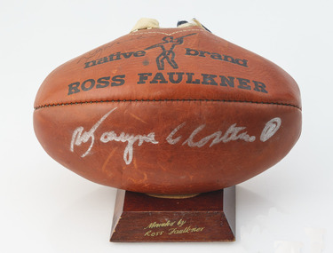 Geelong Football Club
Ross Faulkner Football signed by Doug Wade & Wayne Closter
Doug ‘Pudden’ Wade Born: 16/10/1941 From: Horsham Height: 188cm Weight: 92kg Natural kicking foot: Right Guernsey number: 23 First senior match for Geelong: Round 1, 1961 v Collingwood at Kardinia Park Regarded by many as Geelong’s greatest ever full-forward, his greatest attributes were determination, fast leading, strong marking and prodigious kicking. Often he was able to score goals with 70-metre torpedo punts. Occasionally he scored from drop-kicks. When in top form he was a most inspiring player. If opponents tried to upset his game with niggling tactics he displayed a fiery aspect of his nature, which kept spectators ‘interested’. He played the forward role like an aggressive defender. Probably his most outstanding performance was a 13-goal effort at the Lake Oval in heavy conditions in 1967. A severe knee injury suffered in an interstate match in 1964 restricted his performances for about two seasons. In his time at Geelong he seemed to perform better as the seasons rolled on. He played in North Melb’s Premiership-winning team in 1975, twelve years after the same achievement with the Cats. Total Brownlow Medal votes for Geelong: 34 Premiership team selection: 1963 Night/Pre-Season Premiership team selection: 1961 Captain: 22 matches (1971-72) Club Best & Fairest: 1969 Fifth in club B&F count: 1961 Sixth in club B&F count: 1962 (equal), 1967, 1971 Seventh in club B&F count: 1964, 1972 Tenth in club B&F count: 1966, 1968 Club leading goalscorer: 1961 (51 gls), 1962 (68 gls), 1963 (48 gls), 1964 (41 gls), 1966 (52 gls), 1967 (96 gls), 1968 (64 gls), 1969 (127 gls), 1970 (74 gls), 1971 (94 gls), 1972 (90 gls) Competition leading goalscorer: 1962, 1967, 1969 Instances of seven goals or more in a match for Geelong: 35 Australian Football Hall of Fame inductee (2000) GFC Team of the 20th Century selection (full forward) GFC Hall of Fame inductee (1996) GFC Hall of Fame Legend GFC Life Membership (1968) Career span for Geelong: 1961-72 Total matches for Geelong: Premiership 208, Night/Pre-Season Series 4, Interstate 7 Total goals for Geelong: Premiership 834, Night/Pre-Season Series 11, Interstate 31 Finals matches for Geelong: 12 Finals goals for Geelong: 46 Last senior match for Geelong: Round 22, 1972 v North Melb at Kardinia Park Transferred to North Melb in 1973 Wayne Closter Born: 26/02/1945 From: Darley Height: 180cm Weight: 81kg Natural kicking foot: Right Guernsey number: 1 First senior match: Round 1, 1964 v Melbourne at the MCG In his first season as a listed player, he was selected in the Reserve Grade 1963 Premiership team. A favorable impression of his ability was created in his debut. He was opposed by Melbourne's Frank 'Bluey' Adams on a wing and out-pointed him convincingly. Initially he played many fine matches as a wingman. Later he moved into the centre where his good form continued. Features of his play were strong marking, good control and excellent kicking. He became one of the greatest ever exponents of kicking ambidextrously, and it became difficult to judge which was his natural kicking foot. National Service training obligations during a number of seasons deprived him of the chance of playing 200 matches and to represent Victoria, however the AFL acknowledged his contribution by inducting him into the 200 club during 2007. From 1977 until 1979 he coached the Reserves before spending 10 seasons as a 3GL/K-Rock football commentator. Total Brownlow Medal votes: 29 Captain: 1 match (Round 9, 1974 v South Melb at Kardinia Park) Fourth in club B&F count: 1967, 1971 (equal) Fifth in club B&F count: 1966 Sixth in club B&F count: 1964, 1968, 1972 Eighth in club B&F count: 1970, 1974 Ninth in club B&F count: 1973 GFC Hall of Fame inductee (2002) GFC Life Membership (1971) Career span: 1964-75 Total matches: Premiership 191, Night/Pre-Season Series 2 Total goals: Premiership 72, Night/Pre-Season Series 0 Finals matches: 8 Finals goals: 1 Last senior match: Round 22, 1975 v Fitzroy at Waverley Park Information provided by Col Hutchinson Geelong Cats HistorianRed, slightly deflated Ross Faulkner football. In black on one side of the white laces states - MATCH/Native Brand/ ROSS FAULKNER - with a symbol of figure, and is repeated on the other side states - the football is on a small wooden stand stained dark brown with the text engraved donated by Ross Faulkner - The Football a large player signature on one side in white texta it is believed to be Wayne Closter. There is a signature in pen above the text native on one side of the football by Doug Wade. The football has blue and white ribbons threaded through the laces.Signature Doug Wade and Wayne Closter doug wade, wayne closter, ross faulkner, football, gfc, geelong football club, vietnam war -
 Eltham District Historical Society Inc
Photograph - Digital Photograph, Alan King, Garden Hill, Eltham-Yarra Glen Road, Kangaroo Ground, 3 February 2008
The original house was built around 1850 was one of Kangaroo Ground's earliest homes, part of which remains today. Built by Scottish farmer Andrew Harkness who acquired the property in 1849 at the top of the hill with magnificent panoramic views as far as Kinglake, the same year he married Sarah Oswin. The property was known as Garden Hill from at least 1865. Andrew and Sarah had four sons and five daughters. Harkness was a founder of the Kangaroo Ground School and one of the first to suggest establishing the Eltham District Road Board (1858-71) of which he was a member, the pre-cursor to the Shire of Eltham (1871-1994). He was also a Trustee of the Kangaroo Ground Cemetery. His daughter Fanny married farmer Alexander White who purchased the property in 1893. Alexander White died in 1906 and ownership transferred to Fanny White. Son, Robert White was a Councillor of the Shire of Eltham at the time the Shire acquired two acres of land on the adjacent property from the Mess brothers for the creation of the Shire of Eltham Memorial Park (1921) in which the Shire of Eltham War Memoirial tower was erected (1926). Fanny White donated a small section of land from the Garden Hill property to facilitate entry access to the park. The White family sold the property to Sir Herbert Gepp in 1925. Covered under Heritage Overlay, Nillumbik Planning Scheme. Published: Nillumbik Now and Then / Marguerite Marshall 2008; photographs Alan King with Marguerite Marshall.; p29 Garden Hill, on Yarra Glen Road, Kangaroo Ground, near the War Memorial is well named. The old house and gardens overlook a magnificent panorama extending to Kinglake. The original house, built around 1850, was one of Kangaroo Ground’s earliest, and part of it remains in today’s timber house. The house was built by the early and prominent settler Andrew Harkness. Later it was occupied for a long time by Sir Herbert Gepp, renowned Australia wide.1 Harkness and Gepp are buried in the Kangaroo Ground Cemetery. Scottish farmer Harkness, who was born in 1817, acquired this property in 18492 and he and his family occupied it until the early 1920s. Harkness cleared its 152 acres (61.4 ha), fenced it and grazed sheep and cattle. Harkness proved a valuable community member. When only ten families lived in the district, he and other settlers set up a school in 1852, with Andrew Ross as the first teacher. Harkness was also one of the first to suggest establishing the Eltham District Road Board, of which he was a member for around 15 years. He was also a trustee of the Kangaroo Ground Cemetery. Harkness married in 1854 and had four sons and five daughters. The first part of the timber house he built included a kitchen-living room and a parlor. The living room’s large fireplace was bricked-in and modernised in 1940. Beside it is the old baker’s oven with its original iron door replaced by a wooden one. It is thought two wattle-and-daub huts, used for a bedroom and bathroom, were built to the west. Harkness’ son-in-law, farmer Alexander White, who had seven sons, bought the property in 1893. Harkness’ grand-daughter Flora married Ewen Cameron who became Minister for Health and was later knighted; he was not related to Ewen Hugh Cameron, a Member of the Legislative Assembly. In 1923 the White family sold the property, called Kilby Park, to Sir Herbert Gepp, who renamed it Garden Hill. Gepp used the property, which was still on the original New South Wales title, as a hobby farm. Robert White stayed on to manage the farm for a while, living in a house on the property. Gepp was born in 1877 and at 16 years began working as a junior chemist with the Australian Explosives and Chemical Company at Deer Park near Melbourne. Gepp was a pioneer in applying enlightened labour policies in industry. He initiated the Broken Hill Progress Association, to improve living conditions. It laid the ground work for the welfare schemes pursued by companies after World War One. During the mid 20th century Gepp was the most prominent liberal thinker associated with conservative politics. As a friend of Prime Minister John Curtin, he contributed to post-war reconstruction. Gepp returned to private industry and retired in 1950. Gepp made significant contributions to the solution of the great metallurgical problems of the mining industry. He was an advocate of the role of science in industry, government and the economy and helped to establish several organizations including the CSIR and the Institute of Public Affairs.3 After Sir Herbert died in 1954 his son Orwell continued to farm the property part-time. When Lady Gepp died in 1963, the land was divided among the five children, although Orwell continued to farm it as a hobby. In 1966, a daughter, Mardi Gething, now married, settled in the house. Another daughter, Kathleen, built her house close by on the property. After the Board of Works designated the property as part of a reserve for a possible reservoir, the family sold all, except the minimum 20 acres allowed, to the Board in the 1970s. Orwell then leased what was the family property from the Board to continue grazing. The two sisters and brother continued to live on the property.This collection of almost 130 photos about places and people within the Shire of Nillumbik, an urban and rural municipality in Melbourne's north, contributes to an understanding of the history of the Shire. Published in 2008 immediately prior to the Black Saturday bushfires of February 7, 2009, it documents sites that were impacted, and in some cases destroyed by the fires. It includes photographs taken especially for the publication, creating a unique time capsule representing the Shire in the early 21st century. It remains the most recent comprehenesive publication devoted to the Shire's history connecting local residents to the past. nillumbik now and then (marshall-king) collection, kangaroo ground -
 Eltham District Historical Society Inc
Photograph - Digital Photograph, Marguerite Marshall, Smith Dam, Karingal Drive, Eltham, 19 September 2006
The dam at the entrance to the Nerreman Gateway in Eltham was built according to an internationally acclaimed theory developed by the builder's father. In 1920, Victorian engineer B.A. Smith was awarded the American Society of Civil Engineers J. James R. Cross Gold Medal for his Technical Paper titled 'Arched Dams'. It was the first time this medal had been awarded outside the United States. The concrete arched dam across the Eltham West Drain was built in 1940 by B.A. Smith's son and engineer, D. B. (Bernie) Smith to water the 24 acre (9.75 ha) hobby farm owned by himself and new wife, Isa Smith. Upon completion of the dam a pump-house was constructed beside the creek but before the water could be pumped up the hill they had to dig a trench and lay 500m of 100mm water main to an elevated holding tank. The Smiths made the pump-house their home for several years until they constructed their home at the top of the hill overlooking Eltham and views extending to Kinglake. Following Bernie's death in 1983, Nerreman Park was subdivided between 1993 and 1995. Gordon Ford designed the landscaping and the pump-house was demolished. Covered under Heritage Overlay, Nillumbik Planning Scheme. Published: Nillumbik Now and Then / Marguerite Marshall 2008; photographs Alan King with Marguerite Marshall.; p137 The dam at the entrance to the Nerreman Gateway in Eltham, was built according to an internationally acclaimed theory developed by the builder’s father. In 1920, Victorian engineer B A Smith was awarded the American Society of Civil Engineers J. James R. Croes Gold Medal, for his Technical Paper titled Arched Dams. It was the first time this medal had been awarded outside America. An international example of the application of Smith’s work can be found in the design of the Hoover Dam on the Colorado River, Nevada, USA. Built between 1930 and 1936, it is recognised by the ASCE as one of ‘America’s Seven Modern Civil Engineering Wonders’.1 The concrete arched dam across the Eltham West Drain was built by B A Smith’s son and engineer, D B (Bernie) Smith. Bernie’s dam followed his father’s theory, having a curvature that takes maximum advantage of concrete’s great strength in compression. The water load is carried into the abutments because of this curvature, which permits a wall thickness of only 225 millimetres thick at its crest, despite the dam’s capacity of more than 4.5 megalitres. The Eltham dam was designed to water the 24 acre (9.75 ha) hobby farm belonging to newly married couple Bernie and Isa Smith. Bernie, from Armadale, and Isa, from a farm at Tyntynder near Swan Hill, were attracted to the hilly topography and the creek running through the property. It extended from Ryans Road, Eltham, to Karingal Drive, Montmorency and was adjacent to Meruka Park. The Smiths named it Nerreman Park using the Aboriginal word Nerreman meaning ‘River Bend’ as their creek had a pronounced bend.2 In 1940 the first thing Bernie did was to build a dam, and with Isa’s help, a pump-house, to secure a water supply for their cattle, pigs, chickens, orchard and vegetable gardens. It was also available for the fire-plugs, which they placed all over the property in case of bushfire. The couple built the pump-house beside the creek and installed a Tange three-plunger pump, which had originally supplied the City of Wodonga with water. But before the Smiths could pump water up the hill from the dam they had to dig a trench and lay about 550 yards (500m) of a four-inch (100mm) water main up to an elevated holding tank. The trench was dug with a single furrow plough drawn by an old draught horse. Living in rough conditions did not deter the Smiths, who made the pump-house their home, where they still lived when their first child was born in 1944. They later built their home at the top of their property overlooking Eltham, with magnificent views to Kinglake, the Dandenong Ranges and Melbourne. From 1946 it took them almost 20 years to complete the 36-square house with its 12-foot (3.6m) high ceilings. Material for the concrete roof and walls faced with sandstone, was ripped out of the ground on their property by plough pulled by tandem Clydesdale horses. Isa was a strong woman – two days before their second child was born – she set three huge sandstone boulders in place in the bottom wall of the garage. She also mixed all the cement for the house. A collapsed kitchen wall did not discourage her from rebuilding it in a week, while her husband was away working in the country. She later recalled: ‘We stood back to admire this beautiful wall we’d built and while we were looking at it, it came tumbling down’.3 Following Bernie’s death in 1983, Nerreman Park was subdivided, between 1993 and 1995. Local Gordon Ford designed the landscaping and the pump-house was pulled down. But the dam remains as a reminder of exceptional engineering4 – and of a remarkable couple.This collection of almost 130 photos about places and people within the Shire of Nillumbik, an urban and rural municipality in Melbourne's north, contributes to an understanding of the history of the Shire. Published in 2008 immediately prior to the Black Saturday bushfires of February 7, 2009, it documents sites that were impacted, and in some cases destroyed by the fires. It includes photographs taken especially for the publication, creating a unique time capsule representing the Shire in the early 21st century. It remains the most recent comprehenesive publication devoted to the Shire's history connecting local residents to the past. nillumbik now and then (marshall-king) collection, eltham, karingal drive, smiths dam, bernie smith, gordon ford, isa smith, nerreman gateway, nerreman park estate, dams -
 Eltham District Historical Society Inc
Film - Video (VHS), Nillumbik Shire Council, The Nillumbik Story, 1996
PART 1 – NILLUMBIK (00:00-07:17) Opening features various scenes around Nillumbik Shire. For 40,000 years Nillumbik was the home of the Wurundjeri people. Robert Hoddle gave the district its name. Jock Ryan, then president of Nillumbik Historical Society discusses the names Nillumbik and Diamond Creek. In the late 1830s white occupation began with gold found in Warrandyte in 1851 and 12 years later at Diamond Creek -the Diamond Reef which led to the Caledonian gold rush. Jock Ryan discusses the Diamond Creek mine, which was thriving until it burnt out in 1915. Large numbers of workmen moved into area in late 1870s to construct the Maroondah Aqueduct. With growing population of Melbourne, the nearby Yan Yean system had severely disrupted the flow of the Plenty River, forcing the closure of three flour mills there. The aqueduct came to the rescue carrying water 66km from Healesville to Preston. When the Diamond Creek gold mine burnt down the local economy suffered but fruit growing industry had already been established and Diamond Creek became a thriving fruit growing centre. Interview with Jack Powell, a long-time fruiterer at St Andrews market, his family had lived in the area for a hundred years, 3 to 4 generations, “a lot of hard work”. By the time the railway arrived fruit growing was no longer competitive. The railway brought the city closer and day trippers. The Green Wedge separates the shire from the more densely developed neighbours such as Whittlesea, Doncaster, Templestowe, Bulleen and Greensborough. Population at the time (1996) was 19,000 but links to the past remain strong. Mudbrick houses along the Heritage Trail The saving of Shillinglaw Cottage from demolition in 1963 and relocation brick by brick. PART 2 – ENVIRONMENT (07:18-14:44) Peter Brock (with Bev Brock in background) at St Andrews market discusses his childhood growing up in the district and the environment and the values it instilled upon him and his own family. The Brocks have been in the district since the 1860s. Nillumbik Shire responsible for managing three catchment areas; Diamond Creek, Arthurs Creek and Watsons Creek. Follows the course of the Diamond Creek commencing in Kinglake through the district to its confluence with the Yarra River at Eltham at Eltham Lower Park. Highlights Eltham Lower Park community revegetation program and the newly constructed (1996) viewing platform built of new and recycled timbers at the confluence of the Diamond Creek and Yarra River. Also featured are outdoor recreation on the river and at Eltham Lower Park including the Diamond Valley miniature railway. Sugarloaf reservoir and recreational activities and fishing. Aerial view of Memorial Park and Shire of Eltham War Memorial tower at Garden Hill, Kangaroo Ground. Significant tourism opportunities for the shire with 3 million potential day-trippers in metropolitan Melbourne. Council and community working together to find a way to promote the shires natural and artistic assets. At Arthurs Creek, the Brock family and neighbours working together to take care of their waterway. Peter Brock’s uncle, Sandy Brock talks about environmental management and the Arthurs Creek Landcare group and actions to eradicate blackberry problem. Having previously planted Cypress rows they are replacing them with indigenous species to improve the water supply, keeping cattle out of the creek bed to improve the quality downstream flowing into the Yarra. Eltham East Primary School Band playing “All things bright and beautiful” merges into scenes of the bushland sanctuary set aside by the school in 1980 with unidentified teacher discusses the sanctuary and their education program and school children’s comments. Plight of a family of Wedgetail eagles nesting in the path of a developer’s bulldozer at North Warrandyte and actions to save their nesting areas. PART 3 – ARTS (14:45-22:00) Arts and Jazz festival at Montsalvat featuring interviews with Sigmund Jorgensen discussing Montsalvat and its principles. Also Matcham Skipper. Clifton Pugh’s funeral at Montsalvat and his legacy at Dunmoochin near Cottlesbridge with artists in residence, at the time, Chicago artist Charles Reddington who discusses the benefits of the experience. An unidentified female artist also talks about the program and why people are drawn to the area. Unidentified man on street talking about the amount of talent in the area, artists, poets, musicians, authors. Artist Ming Mackay (1918-2009) interviewed talking about the people she mixes with on “the Hill”. Works of local artists are displayed Eltham Library Community Gallery and Wiregrass gallery with a new coffee shop at the Wiregrass making it an even more popular destination. Music at St Andrews Hotel (may be a little bit country) and the Saturday market where likely to hear anything. Sellers and patrons at the market asked about what attracts them to the market and where they came from. Scenes of poets/authors giving readings. CREDITS Music by John Greenfield from the CD Sweet Rain “The Snow Tree”, Uncle Music UNC 2001 Cameras - David Mirabella and Peter Farragher Editor – Olwyn Jones Written and Produced by Jason Cameron A Jason Cameron Proction for Nillumbik ShireProvides a record of the relatively newly created Shire of Nillumbik at the time and the features and attactions of the shire in its people arts, culture and environmentVHS Cassette (five copies) DVD (one copy) Converted to MP4 file format 0:22:00, 1.60GBvideo recording, arthurs creek, arthurs creek landcare group, artists, artists in residence, arts, arts festival, authors, blackberry, brock family, bulldozer, bulleen, bushland sanctuary, caledonian gold rush, charles reddington, clifton pugh, cottlesbridge, cypress rows, developer, diamond creek, diamond creek mine, diamond reef, diamond valley miniature railway, doncaster, dunmoochin, education program, eeps, eltham, eltham east primary school, eltham east primary school band, eltham library community gallery, eltham lower park, environment, fishing, flour mill, fruit growing, fruiterer, garden hill, gold mining, green wedge, greensborough, heritage trail, hurstbridge railway line, jazz festival, jock ryan, kangaroo ground, kangaroo ground tower, kinglake, maroondah aqueduct, matcham skipper, memorial park, ming mackay (1918-2009), montsalvat, mudbrick houses, music, musicians, nesting area, nillumbik historical society, nillumbik shire, north warrandyte, old timer, orchards, peter brock, plenty river, poets, population, recreation, recreational activities, revegetation, robert hoddle, sandy brock, shillinglaw cottage, shire of eltham war memorial, sigmund jorgensen, st andrews hotel, st andrews market, sugarloaf reservoir, templestowe, the hill, tourism, viewing platform, warrandyte, water catchment area, watsons creek, wedgetail eagle, whittlesea, wiregrass gallery, wurundjeri, yarra river, jack powell -
 Eltham District Historical Society Inc
Work on paper - Folio, Register of Significant Trees, Shire of Eltham, c.1993
In 1983, the National Trust advised the Shire of Eltham that it was investigating a number of trees within the shire which had been nominated for recording the Register of Significant Trees of Victoria. The trees involved were described in the Shire of Eltham Historical Society Newsletter No. 29, March 1983 as follows:- 1. Eucalyptus melliadora (Yellow box) . a) An outstanding mature specimen 42 metres high in Laughing Waters Road, Eltham. b) Another mature specimen in Arthurs Creek road, Hurstbridge is reported to be the tree under which the bushranger Robert Bourke was tied after he shot and killed Henry Hurst in 1866 . 2. Quercus robur (English Oak). a) "Donaldson's Oak", Donaldsons Road, Kangaroo Ground was planted by John Donaldson from seed collected from Windsor Great Park in 1878. b) "Wippells Oak". This now misshapen tree is located on the St. Andrews Road near the Kangaroo Ground Fire Station. Its origins may have been similar to Donaldson's Oak, and as a young tree it apparently slipped from higher up the hill during wet weather. Both oaks are of local historical importance. 3. Eucalyptus globulus (Blue Gum). A large mature specimen at the corner of the Kangaroo Ground-St. Andrews Road and Bakehouse Road, Panton Hill. 4. Plantanas acerifolia (Plane tree) A number of trees forming the Avenue of Honour to Eltham's First World War soldiers along Main Road between Dalton and Pitt Streets, Eltham. 5. Pinus canariensis (Canary Island Pine), Pinus pinea, (Stone pine) and Cedras altlantica, (Cedar) These trees are located at the Hurst family graves in the grounds of the Hurstbridge Pre-school Centre. In 1991 the Shire of Eltham introduced controls into its planning scheme to protect sites of architectural, historic or conservation interest and significant trees. The controls were approved by the Minister for Planning and Housing. As advised in the Shire of Eltham Historical Society Newsletter No. 78, May 1991, a planning permit is required to demolish or alter any listed building or to destroy, lop or remove any listed tree. Provision is made for comments to be obtained from the National Trust or Historic Buildings Council in considering any applications. The buildings and trees listed were: Buildings: 250 Bolton Street Eltham (former Walter Withers home) "Rosehill" - Bonds Road Lower Plenty St Andrews Church of England - St Andrews "Montsalvat" - Hillcrest Avenue Eltham St Margarets Church and former vicarage - Pitt Street Eltham Presbyterian Church - Kangaroo Ground Parks and Environment Office (former police quarters) Main Road Eltham Former Court House - Main Road Eltham "Shillinglaw Cottage" - Main Road Eltham "The Robins" - Kangaroo Ground Road Warrandyte Trees: "Donaldsons Oak" - Donaldsons Road Kangaroo Ground Yellow Box - Laughing Waters Road Eltham Yellow Box - Arthurs Creek Road Hurstbridge Wippells Oak - St Andrews Road Kanqaroo Road Pines and Cedar - Hurst family cemetery Greysharps Road Hurstbridge Yellow Box - Parsons Road Eltham A large Blue Gum at Panton Hill has been listed but has recently died (1991). In 1993 work by Council Parks and Environment staff and volunteers resulted in the preparation of a Significant Tree Register listing forty-one trees or groups of trees. According to Shire of Eltham Historical Society Newsletter No. 91, March 1993, a similar number remained to be assessed for inclusion in the register. There is a wide range of indigenous and planted trees on private and public land and extending through the Shire of Eltham from Lower Plenty to Kinglake. Most can be viewed from publicly accessible locations. The Significant Tree Register lists 41 trees or groups of trees throughout the Shire. It contains a wide range of naturally occurring and planted trees. They have been assessed according to eleven criteria including size, age, rarity, historical value and the like. The list includes large old Red Gums at Lower Plenty, historic Oaks at Kangaroo Ground and Mountain Ash at Kinglake. The register includes a set of slides showing each tree. Garry Bartlett of the Council's Parks and Environment Section and Faye Shepherd were extensively involved in establishment of the register (Newsletter No. 93, November 1993). In 1999 Niliumbik planners prepared an amendment to the Planning Scheme to provide protection for approximately 200 of the places listed in the heritage studies and also in the Significant Tree Register commenced by the Eltham Council (Eltham District Historical Society Newsletter No. 127, July 1999. In 2004, The Register of Significant Trees was presented to the Eltham District Historical Society by Nillumbik Shire Council as part of a wider collection of of its memorabilia of the former Eltham Shire Council (EDHS Newsletter No. 159, July 2004. Album of loose handmade paper sheets contained within a handmade slip cover constructed of handcrafted card with encapsulated flora material (flowers, vines, ferns) and tinted. Each page also contains an embedded/adhered fern leaf also tinted with lacqueur or similar, text as appropriate in ink by hand calligraphy. Each page also has a white protective sheet cut to size and adhered to back surface with sticky tape and folded over face of page. Pages variously have photographs and coloured masks adhered with a gum resin. Over time much of this resin has let go and photos/masks have been reattached using acid free archival safe adhesive. 15 pages 41 x 29 cm inclusive of 3 blank pages. Slip case 42 x 30 x 1 cm; face cover of slip case has broken off at left hand margin as insufficient depth/flexibility for contents.arthurs creek road, blue gum (eucalyptus globulus), canary island pine (pinus canariensis), couties road, donaldsons oak, donaldsons road, eltham, english oak (quercus robur), eucalyptus melliodora, graysharps road, hurst tree, hurstbridge, ironbark (eucalyptus tricarpa), ironbark hill, kangaroo ground, kangaroo ground-kinglake road, laughing waters road, panton hill hotel, panton hill, parsons road, significant trees register, sonia van bodegraven, sonjart, stone pine (pinus pinea). atlantic cedar (cedrus atlantica), wippells oak, yellow box gum (eucalyptus melliodora), yellow box gum