Showing 2136 items matching " facilities"
-
 Bendigo Historical Society Inc.
Document - NORMAN OLIVER COLLECTION: MAYOR SPEAKS 1 MAY 1965
... Topics include : the Central Plant Depot of the State Rivers and Water Supply Commission at Golden Square, BLB Corporation, invitations to the Mayoral Ball, opening ceremony of Golden Square High School, need for development and improved organisation with sporting facilities for girls, and street lighting....Topics include : the Central Plant Depot of the State Rivers and Water Supply Commission at Golden Square, BLB Corporation, invitations to the Mayoral Ball, opening ceremony of Golden Square High School, need for development and improved organisation with sporting facilities for girls, and street lighting. Document NORMAN OLIVER COLLECTION: MAYOR SPEAKS 1 MAY 1965 ...The Norman Oliver collection. Norman Oliver was three times Mayor of Bendigo - 1950-51, 1964-65, 1970-71. Three typed pages titled 'Mayor Speaks', with the date in black ink across the top of the first page - 1/5/65. Topics include : the Central Plant Depot of the State Rivers and Water Supply Commission at Golden Square, BLB Corporation, invitations to the Mayoral Ball, opening ceremony of Golden Square High School, need for development and improved organisation with sporting facilities for girls, and street lighting.bendigo, council, report, norman joseph oliver , councillor norman oliver. mayor of bendigo. b.l.b. corporation. central plant depot. -
 Ringwood and District Historical Society
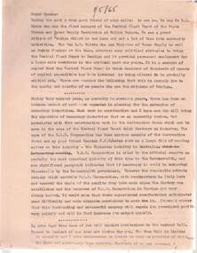
Flyer, Land Sale Advertisement - Banool Gardens Subdivision, Ringwood, Vic. c.1985
... Double-sided advertisement for Banool Gardens subdivision with site plan, location plan, terms of sale, and summary of homesite features and local services & facilities. Subdivision includes Wonga Road, Hamilton Drive, Tinworth Place, Andrea Parade and Benjamin Court, Ringwood North. ...Double-sided advertisement for Banool Gardens subdivision with site plan, location plan, terms of sale, and summary of homesite features and local services & facilities. Subdivision includes Wonga Road, Hamilton Drive, Tinworth Place, Andrea Parade and Benjamin Court, Ringwood North. ...Double-sided advertisement for Banool Gardens subdivision with site plan, location plan, terms of sale, and summary of homesite features and local services & facilities. Subdivision includes Wonga Road, Hamilton Drive, Tinworth Place, Andrea Parade and Benjamin Court, Ringwood North. Managing agent - Ollson Real Estate Pty. Ltd., North Croydon Shopping Plaza, Maroondah Highway. Croydon, Vic. 3136. Telephone 726 9988 After Hours 876 4190. Project by Darnley Developments (Vic.) Pty. Ltd. Accompanying handwritten notation by Richard Carter R.E.S.I. - "Part of original Banool property (Mahon, sold to Stallman, sold to McMahon, sold to Len Macley etc etc). Hamilton Drive named after Lynn Hamilton McMahon, Tinworth Place after his son-in-law, David Tinworth". -
 Ringwood and District Historical Society
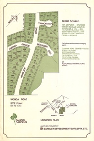
Map - Plan of Subdivision, Parts of Crown Portions 10 and 10B Parish of Ringwood - 1958
... Accompanying clipping on scrap paper backing from Land Sale Brochure with description of available services and local facilities and terms of sale - £75 Deposit £10 Monthly....Accompanying clipping on scrap paper backing from Land Sale Brochure with description of available services and local facilities and terms of sale - £75 Deposit £10 Monthly. ...Folded subdivision map of 15 residential allotments in McKay Court Ringwood, off Wantirna Road north of Canterbury Road. Rubber stamped by Surveyors and Chartered Engineers J.S. Watson & Associates, Mornington and South Yarra, with illegible signature dated 17/2/58. Handwritten notations indicating allotment sale names and amounts or where passed in. Accompanying clipping on scrap paper backing from Land Sale Brochure with description of available services and local facilities and terms of sale - £75 Deposit £10 Monthly. -
 Ringwood and District Historical Society
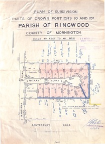
Flyer, Land Sale Brochure, Kardinia Park Estate, North Ringwood, Vic. - circa 1948
... Folded buff-coloured land sale advertisement for Kardinia Park Estate in Warranwood area of North Ringwood, including terms of sale, area map, layout plan of the estate, and summary of local facilities and services. Front page features photograph of a man and dog in front of a house captioned as Lot 1 on four acres shown on the estate layout as cnr of Brysons Road and Range View Parade (later Omeo Parade). ...Folded buff-coloured land sale advertisement for Kardinia Park Estate in Warranwood area of North Ringwood, including terms of sale, area map, layout plan of the estate, and summary of local facilities and services. Front page features photograph of a man and dog in front of a house captioned as Lot 1 on four acres shown on the estate layout as cnr of Brysons Road and Range View Parade (later Omeo Parade). ...Folded buff-coloured land sale advertisement for Kardinia Park Estate in Warranwood area of North Ringwood, including terms of sale, area map, layout plan of the estate, and summary of local facilities and services. Front page features photograph of a man and dog in front of a house captioned as Lot 1 on four acres shown on the estate layout as cnr of Brysons Road and Range View Parade (later Omeo Parade). Second page includes bushland swimming pool photograph and promotional information for prospective buyers.Subdivision includes Kardinia Crescent, Wonga Road, Brysons Road, Range View Parade (later Omeo Parade), Motor Coach Road (later Wonga Park Road, then Warranwood Road). (Agent/s) T.A.W. Burkitt, Main Street, Ringwood, Phone (9 to 6) Ringwood 242, Evenings, Ringwood 157, and J. McEwan & Co, 317 Collins Street, Melbourne, Phone 6750 Central. -
 Melbourne Tram Museum
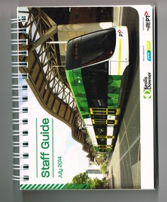
Document - Guide Book/notes, Yarra Trams, "Staff Guide July 2014", 2014
... Has a message from the CEO, Clement Michel, listing of contents on page 3 including Myki, location information of Melbourne facilities eg churches, hotels, museums etc, including route designation, TramTracker, tram stops by route and useful numbers....Has a message from the CEO, Clement Michel, listing of contents on page 3 including Myki, location information of Melbourne facilities eg churches, hotels, museums etc, including route designation, TramTracker, tram stops by route and useful numbers. ...Book, 146 pages, including card covers, white spiral bound titled "Staff Guide July 2014", with a photo of E 6001 at Southern Cross on the front cover along with logos for Keolis Downer, Yarra Trams and Public Transport Victoria (PTV). Has a message from the CEO, Clement Michel, listing of contents on page 3 including Myki, location information of Melbourne facilities eg churches, hotels, museums etc, including route designation, TramTracker, tram stops by route and useful numbers.trams, tramways, yarra trams, routes, myki, melbourne, tram stops, staff, tram 6001 -
 Eltham District Historical Society Inc
Photograph, N. J. Tillings Timber Factory, 15 June, 1975, 15/06/1975
... Off street parking facilities most important." . The front of the photo has pen marks indicating points of interest....Off street parking facilities most important." . The front of the photo has pen marks indicating points of interest. 1 black and white photograph printed with white border N. ...N. J. Tillings Timber Factory was part of the Brougham Street, Light industrial area, Eltham. Brick bulidings includes signage: Wakefield Pr... (printer?) No 17 Building C. This is one of 7 B/W 8x10 inch photos with notes on obverse by Dick Crichton. Accompanying letter from Florence Chrichton 2013 : "Originally sent to Shire of Eltham Engineer, Mr. McDonald. [These photographs were part of their campaign to the Shire of Eltham in 1975] claiming that the zoning regulations were being breached by the occupants of various factories in the nearby light industrial zone [Brougham Street, Eltham] - to the detriment of those living in adjoining residential zones, and that, despite .. earlier objections and complaints, nothing was done about it."1 black and white photograph printed with white borderInscribed on back: "Weekend photograph of factories in Brougham Street surrounded by by residential zone. On weekdays cars surround premises - these have been built approx. two years - where is the landscaping? * Undeveloped light industrial land. Careful planning needed for future. Being on high elevations backs of future buildings will be seen from Main Road Eltham and future Art Centre complex. Also Bolton Street becoming heavily used arterial road. Off street parking facilities most important." . The front of the photo has pen marks indicating points of interest.industrial estate, brougham street, eltham -
 Marysville & District Historical Society
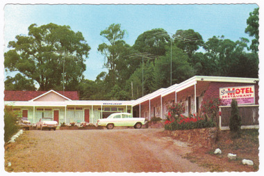
Postcard (item) - Colour postcard, John Sands Pty. Ltd, Unknown
... ./ Tiled shower recess and toilet,/ bedside lamps, T.V., radio, refrigerator. Tea-making facilities./ Breakfast served to units. Parking at door. ..../ Tiled shower recess and toilet,/ bedside lamps, T.V., radio, refrigerator. Tea-making facilities./ Breakfast served to units. Parking at door. ...A colour postcard of the Scenic Motel in Marysville. The postcard was produced by John Sands Pty. Ltd. as a souvenir of Marysville.A colour postcard of the Scenic Motel in Marysville. The postcard was produced by John Sands Pty. Ltd. as a souvenir of Marysville.Sandscene/International PLACE/STAMP/HERE PRINTED IN/ AUSTRALIA Post Card POST OFFICE/PREFERRED John Sands Pty. Ltd., Printers, Australia SPVI-SCENIC MOTEL, 5 DARWIN STREET, MARYSVILLE,/ Phone 92 "Modern luxuriously appointed sound proof bedsitting rooms./ all units wall-to-wall carpets./ Tiled shower recess and toilet,/ bedside lamps, T.V., radio, refrigerator. Tea-making facilities./ Breakfast served to units. Parking at door. Magnificent Scenic/ Views. Restaurant open 6 p.m. A La Carte Meals."marysville, victoria, australia, scenic motel, accommodation, postcard, john sands pty. ltd., souvenir -
 Kiewa Valley Historical Society
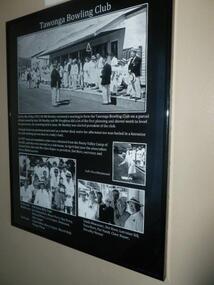
Posters - "Tawonga Remembers" x 7, 2016
... Tawonga consisted of essential amenities including a store, school, Butter factory, sporting facilities, post office, hall and hotel. Activities involved sport, social get togethers eg. dances, fund raising, CWA etc....Tawonga consisted of essential amenities including a store, school, Butter factory, sporting facilities, post office, hall and hotel. Activities involved sport, social get togethers eg. dances, fund raising, CWA etc. ...The town of Tawonga is in the Kiewa Valley surrounded by farmland. It is adjacent to Mt Beauty (built from 1946), an SECV town built for the workers on the Kiewa Hydro Electric Scheme which was being constructed from 1911 to 1961. Tawonga consisted of essential amenities including a store, school, Butter factory, sporting facilities, post office, hall and hotel. Activities involved sport, social get togethers eg. dances, fund raising, CWA etc.The posters are a collection of historical photos, documentation and information regarding the history of the town of Tawonga, which is the centre of a farming community in the Kiewa Valley. Posters framed with thin black plastic strip, covered by glass. Each one has a title re 'Tawonga Remembers' and includes print and photos. 1. Tawonga Bowling Club 1953 includes 5 B&W photos on black background. 2. Bogong Hotel 4 B&W photos on black background. 3. Bogong Hotel 1970s - 2011 3 B&W photos and 3 coloured photos on black background 4. Tawonga Butter Factory 3 B&W photos on sepia background. 5. Tawonga Store 2 B&W photos on black background. 6. Post Office 3 B&W photos and 1 coloured photo on sepia background. 7. Debutante Balls held in the Hall 2 B&W photos on sepia background.tawonga, photos of early tawonga, kiewa valley, tawonga remembers -
 Kiewa Valley Historical Society
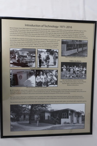
Posters - "Tawonga Remembers" x 5
... Tawonga consisted of essential amenities including a store, school, butter factory, sporting facilities, post office, hall and hotel. Activities involved sport, social get togethers eg. dances, fundraising, CWA etc....Tawonga consisted of essential amenities including a store, school, butter factory, sporting facilities, post office, hall and hotel. Activities involved sport, social get togethers eg. dances, fundraising, CWA etc. ...The town of Tawonga is in the Kiewa Valley surrounded by farmland. It is adjacent to Mt Beauty (built from 1946), an SECV town built for the workers on the Kiewa Hydro Electric Scheme which was being constructed from 1911-to 1961. Tawonga consisted of essential amenities including a store, school, butter factory, sporting facilities, post office, hall and hotel. Activities involved sport, social get togethers eg. dances, fundraising, CWA etc.The posters are a collection of historical photos, documentation and information regarding the history of the town of Tawonga, which is the centre of a farming community in the Kiewa Valley.Posters framed with thin black plastic strip, covered by glass. Each one has a title re "Tawonga Remembers" and includes print and photos in black and white. Beige background. 1.Butcher Shop and Slaughter Yard; 2. Tawonga Saw Mill; 3. Post Office; 4. Tawonga District Hospital (2 pages); 5. Introduction of Technology: 1971-2016tawonga, photos of early tawonga, kiewa valley, tawonga remembers, businesses -
 Kiewa Valley Historical Society
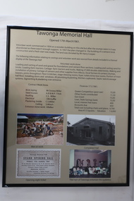
Posters - "Tawonga Remembers" x 5
... Tawonga consisted of essential amenities including a store, school, butter factory, sporting facilities, post office, hall and hotel. Activities involved sport, social get togethers eg. dances, fundraising, CWA etc. ...Tawonga consisted of essential amenities including a store, school, butter factory, sporting facilities, post office, hall and hotel. Activities involved sport, social get togethers eg. dances, fundraising, CWA etc. ...The town of Tawonga is in the Kiewa Valley surrounded by farmland. It is adjacent to Mt Beauty (built from 1946), an SECV town built for the workers on the Kiewa Hydro Electric Scheme which was being constructed from 1911-1961. Tawonga consisted of essential amenities including a store, school, butter factory, sporting facilities, post office, hall and hotel. Activities involved sport, social get togethers eg. dances, fundraising, CWA etc. The posters are a collection of historical photos, documentation and information regarding the history of the town of Tawonga, which is the centre of a farming community in the Kiewa Valley.Posters framed with thin black plastic strip, covered, by glass. Each one has a title re "Tawonga Remembers" and includes print and photos in black and white. Beige background. 1. Tawonga Memorial Hall 2. Opening of the Second Public Hall 1925 3. Public Hall for Tawonga 4. Tawonga Debutante Ball 1947 5. Tawonga Hall Ghosttawonga, photos of early tawonga, kiewa valley, tawonga remembers, tawonga hall -
 Kiewa Valley Historical Society
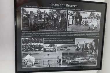
Posters - "Tawonga Remembers" x 4
... Tawonga consisted of essential amenities including a store, school, butter factory, sporting facilities, post office, hall and hotel. Activities involved sport, social get togethers eg. dances, fundraising , CWA etc....Tawonga consisted of essential amenities including a store, school, butter factory, sporting facilities, post office, hall and hotel. Activities involved sport, social get togethers eg. dances, fundraising , CWA etc. ...The town of Tawonga is in the Kiewa Valley surrounded by farmland. It is adjacent to Mt Beauty (built from 1946), an SECV town built for the workers on the Kiewa Hydro Electric Scheme which was being constructed from 1911 to 1961. Tawonga consisted of essential amenities including a store, school, butter factory, sporting facilities, post office, hall and hotel. Activities involved sport, social get togethers eg. dances, fundraising , CWA etc.The posters are a collection of historical photos, documentations and information regarding the history of the town of Tawonga, which is the centre of a farming community in the Kiewa Valley.Posters framed with thin black plastic strip, covered, by glass. Each one has a title re "Tawonga Remembers" and includes print and photos in black and white. Black background. 1. Recreation Reserve 2. St Aidan's Church 3. Lois Pearce 4. Boarding Housetawonga, photos of early tawonga, kiewa valley, tawonga remembers, tawonga businesses -
 Kiewa Valley Historical Society
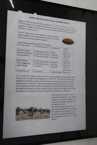
Posters - "Tawonga Remembers" x 8
... Tawonga consisted of essential amenities including a store, school, butter factory, sporting facilities, post office, hall and hotel. Activities involved sport, social get togethers eg. dances, fundraising, CWA etc. ...Tawonga consisted of essential amenities including a store, school, butter factory, sporting facilities, post office, hall and hotel. Activities involved sport, social get togethers eg. dances, fundraising, CWA etc. ...The town of Tawonga is in the Kiewa Valley surrounded by farmland. it is adjacent to Mt Beauty (built from 1946), an SECV town built for the workers on the Kiewa Hydro Electric Scheme which was being constructed from 1911 to 1961. Tawonga consisted of essential amenities including a store, school, butter factory, sporting facilities, post office, hall and hotel. Activities involved sport, social get togethers eg. dances, fundraising, CWA etc. The posters are a collection of historical photos, documentations and information regarding the history of the town of Tawonga, which is the centre of a farming community in the Kiewa Valley.Posters framed with thin black plastic strip, covered by glass. Each one has a title re "Tawonga Remembers" and includes print and photos in black and white. White background. 1. Where and How Kiewa Valley Soldiers Served; 2. Tawonga and Dederang Servicemen; 3. Kergunyah and Gundowring Servicemen and Women; 4. Kiewa and Tangambalanga Servicemen.5. Sacrifice and Honour; 6. The End of the Great War; 7. World War 1914-18; 8. Soldiers in Uniform (Black background and glass cracked) tawonga, photos of early tawonga, kiewa valley, tawonga remembers, ww1 -
 Port of Echuca
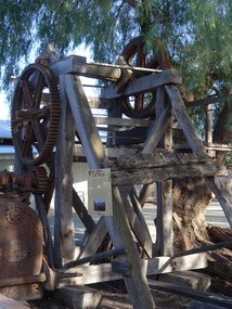
Machine - Log Winch, Early 1920
... The log winch is a rare and unusual item of considerable interest in the context of the Echuca and Murray River Red Gum industry The winch is of historical significance for its association with the Evans Sawmill from early to mid-twentieth century, It helps demonstrate the role of the industry in the exploitation of the Murray River red gum timber, the process of converting the forests to a saleable commodity and the relationship between the industry the river Echuca township and the transport facilities of the wharf, paddlesteamers and the railway,...Port of Echuca 74 Murray Esplanade Echuca the-murray The log winch is a rare and unusual item of considerable interest in the context of the Echuca and Murray River Red Gum industry The winch is of historical significance for its association with the Evans Sawmill from early to mid-twentieth century, It helps demonstrate the role of the industry in the exploitation of the Murray River red gum timber, the process of converting the forests to a saleable commodity and the relationship between the industry the river Echuca township and the transport facilities of the wharf, paddlesteamers and the railway, The log winch is a rare and unusual item of considerable interest in the context of the Echuca and Murray River Red Gum industry, and the transport industry of Victoria, The structure is composed of red gum timber with four main posts with diagonal braces supporting a cog system and winch cable on the drive shaft at the top of the structure There is a platform on one side of the structure to enable the operator to reach the operating levers. ...The log winch is a rare and unusual item of considerable interest in the context of the Echuca and Murray River Red Gum industry The winch is of historical significance for its association with the Evans Sawmill from early to mid-twentieth century, It helps demonstrate the role of the industry in the exploitation of the Murray River red gum timber, the process of converting the forests to a saleable commodity and the relationship between the industry the river Echuca township and the transport facilities of the wharf, paddlesteamers and the railway,The log winch is a rare and unusual item of considerable interest in the context of the Echuca and Murray River Red Gum industry, and the transport industry of Victoria,The structure is composed of red gum timber with four main posts with diagonal braces supporting a cog system and winch cable on the drive shaft at the top of the structure There is a platform on one side of the structure to enable the operator to reach the operating levers. There was also a rod control to regulate the winch engine and boiler. -
 Kiewa Valley Historical Society
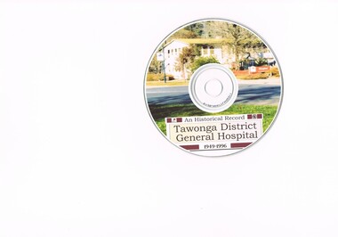
DVD - Tawonga Hospital, early 2000's
... It was a period of intense evolution of both the expansion in population and the increase in the medical facilities provided by a once slightly remote rural hospital to that of one of a regional and alpine advanced hospital. ...It was a period of intense evolution of both the expansion in population and the increase in the medical facilities provided by a once slightly remote rural hospital to that of one of a regional and alpine advanced hospital. ...This DVD of the development of the Tawonga and Mount Beauty General Hospital covers the time period 1949 to 1996. It was a period of intense evolution of both the expansion in population and the increase in the medical facilities provided by a once slightly remote rural hospital to that of one of a regional and alpine advanced hospital. The population expansion of the region during this period was due to the greater growth of local (Kiewa Hydro Scheme) and tourism population provided the need of advancement in the modus operandi of hospital treatments.This DVD details the medical evolution in rural areas and the greater availability of medical professionals to rural areas. The relative isolation of the Kiewa Valley before transport and communications were greatly advanced in the mid to late 1900's resulted in not only increases in population but also the tourism trade. These two important factors required the degree of professionalism for the hospital and with an increasing aged population the diversity into aged care.This DVD has a coloured photograph of the Tawonga District Hospital as a background drop. Printed in black on the front 'An Historical Record / Tawonga District General Hospital / 1949 - 1996.'On the DVD label "An Historical record" below this "Tawonga District General Hospital" below this "1946-1996"hospital dvd, tawonga, mount beauty hospital, specialised treatments -
 Glen Eira Historical Society
Article - CLARA HOUSE
... This file contains 1 item: 1/A clipping from the Leader newspaper (titled ‘House offers refuge for women’, by Lorna Swinstead, dated 10/08/1988) about Clara House, a facility in South Caulfield designed to accommodate women in the early stages of mental illness without separating them from their children, as conventional facilities tend to. The remainder of the clipping consists solely of unrelated advertisements, which nevertheless are retained due to revealing the provenance....Glen Eira Historical Society 965 Glen Huntly Rd Caulfield VIC 3162 melbourne This file contains 1 item: 1/A clipping from the Leader newspaper (titled ‘House offers refuge for women’, by Lorna Swinstead, dated 10/08/1988) about Clara House, a facility in South Caulfield designed to accommodate women in the early stages of mental illness without separating them from their children, as conventional facilities tend to. The remainder of the clipping consists solely of unrelated advertisements, which nevertheless are retained due to revealing the provenance. ...This file contains 1 item: 1/A clipping from the Leader newspaper (titled ‘House offers refuge for women’, by Lorna Swinstead, dated 10/08/1988) about Clara House, a facility in South Caulfield designed to accommodate women in the early stages of mental illness without separating them from their children, as conventional facilities tend to. The remainder of the clipping consists solely of unrelated advertisements, which nevertheless are retained due to revealing the provenance.clara house, south caulfield, geroe clara dr, women’s refuges, caulfield south, malvern-caulfield progress, welfare establishments, woods anne, swinstead lorna, office of psychiatric services -
 Montmorency–Eltham RSL Sub Branch
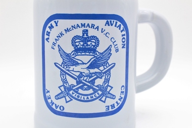
Memorabilia - Cup
... Since then, the RAAF Station Oakey facilities have been used few times for some minor activities. ...Since then, the RAAF Station Oakey facilities have been used few times for some minor activities. ...The Oakey Army Aviation Centre is a training facility formed in October 1943 at Oakey, Queensland. It was built with the purpose of providing a maintenance facility: the units would erect, repair and insect aircrafts and engines. At the end of the war in 1945, the depot was used to store surplus aircraft. In early 1946, the RAAF Station Oakey was disbanded and categorised ‘to be retained but not maintained’. Since then, the RAAF Station Oakey facilities have been used few times for some minor activities. Although there are no information relating to the owner or usage of the cup; it holds historic significance for its direct link with the Australian Army Aviation Centre in Oakey and its involvement in World War II; and more generally for its link to the Australian Army.Large white cup with a handle; decorated with a blue ink symbol (displaying a crown and below it, a bird handling two swords) and blue ink inscriptions (from the Army Aviation Centre Oakey). Inscription on top: 'Frank McNamara VC Club' Inscription at the bottom of the symbol: 'Vigilance' Inscription circling the symbol: 'Army Aviation Centre Oakey' -
 Federation University Historical Collection
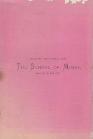
Booklet - Annual Report, The Ballarat Star, The School of Mines Ballaarat Annual Report, 29 December, 1879, 1879
... The School of Mines Annual Report, 29 December, 1879, Bequest - form of, Certificates granted by Council, Donations of Books, Specimens and facilities for forwarding, Examiners, Extracts from Visitors Book, Fees - table of, Geological Indications for Determining Position of Lodes, General Balance Sheet, Honorary Correspondents, Laboratories - cost of, Lecturers, Life Governors, Museums, Office-Bearers, Statement of Receipts and Expenditure, Subscriptions and Donations, Treatment of Tailings, Visitors invited to inspect...Barker Library (top floor) Mount Helen goldfields The School of Mines Annual Report, 29 December, 1879, Bequest - form of, Certificates granted by Council, Donations of Books, Specimens and facilities for forwarding, Examiners, Extracts from Visitors Book, Fees - table of, Geological Indications for Determining Position of Lodes, General Balance Sheet, Honorary Correspondents, Laboratories - cost of, Lecturers, Life Governors, Museums, Office-Bearers, Statement of Receipts and Expenditure, Subscriptions and Donations, Treatment of Tailings, Visitors invited to inspect the school of mines annual report life governors honorary correspondents office-bearers subjects and lecturers subjects and examiners fees mr j. noble r. f. hudson mr hoelscher dr usher r. m. serjeant h. r. caselli j. campbell j. flude g. preshaw j. oddie t. mann a. h. king w. hy. barnard geo. perry certificates mr denny mr roberts mr john hickman his excellency sir george ferguson bowen his worship w. g. murray sir c. gavan duffy b. g. davies john whiteman e. j. dixon w. murray ross j. m. templeton friendly societies royal commission the right rev. dr. thornton benjn.h. dods john garbutt rev. f. coghlan the right rev. dr o'connor - bishop of ballaarat j. e. bromby his excellency sir wm. drummond jervois h. b. de la poer wall charles h. pearson w. carrington t. brodribb wm. nicholas t. couchman j. alfd. griffiths joseph flude charles flude John Hickman W.G. ...The School of Mines Annual Report, 29 December, 1879, Bequest - form of, Certificates granted by Council, Donations of Books, Specimens and facilities for forwarding, Examiners, Extracts from Visitors Book, Fees - table of, Geological Indications for Determining Position of Lodes, General Balance Sheet, Honorary Correspondents, Laboratories - cost of, Lecturers, Life Governors, Museums, Office-Bearers, Statement of Receipts and Expenditure, Subscriptions and Donations, Treatment of Tailings, Visitors invited to inspectPink booklet of 40 pages, Annual Report 1879. Image of the Patent Grinder and Amalgamator.the school of mines, annual report, life governors, honorary correspondents, office-bearers, subjects and lecturers, subjects and examiners, fees, mr j. noble, r. f. hudson, mr hoelscher, dr usher, r. m. serjeant, h. r. caselli, j. campbell, j. flude, g. preshaw, j. oddie, t. mann, a. h. king, w. hy. barnard, geo. perry, certificates, mr denny, mr roberts, mr john hickman, his excellency sir george ferguson bowen, his worship w. g. murray, sir c. gavan duffy, b. g. davies, john whiteman, e. j. dixon, w. murray ross, j. m. templeton, friendly societies royal commission, the right rev. dr. thornton, benjn.h. dods, john garbutt, rev. f. coghlan, the right rev. dr o'connor - bishop of ballaarat, j. e. bromby, his excellency sir wm. drummond jervois, h. b. de la poer wall, charles h. pearson, w. carrington, t. brodribb, wm. nicholas, t. couchman, j. alfd. griffiths, joseph flude, charles flude, john hickman, w.g. murray, gavin duffy, jospeh gflude, james oddie, william barnard, george perry, bejamin dodds -
 Sunshine and District Historical Society Incorporated
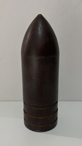
Weapon - Projectile (Reject) Armour Piercing
... 2nd World War - Various industries through Defense Department set up manufacturing facilities for Armaments - McKAY MASSEY HARRIS had one such facility. ...2nd World War - Various industries through Defense Department set up manufacturing facilities for Armaments - McKAY MASSEY HARRIS had one such facility. ...2nd World War - Various industries through Defense Department set up manufacturing facilities for Armaments - McKAY MASSEY HARRIS had one such facility. Corner Hertford & Hampshire Rds, for manufacture of Armour Piercing Shells. Materials: Steel Production Method: Shell Lathe & Heat Treatment When made: 1943 When used: 1943 - 45 Where made: Australia, Victoria, Sunshine Where used: Australia, Victoria, War zonesProjectile (Reject) Armour Piercingprojectile, h.v. mckays massey harris, sunshine harvester works, manufacturing -
 Kew Historical Society Inc
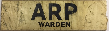
Uniform, Air Raid Precautions Warden Armlet, c.1941
... Air raid wardens managed groups of people in using air raid facilities that were constructed throughout the district. ...Air raid wardens managed groups of people in using air raid facilities that were constructed throughout the district. ...Part of a suite of materials used by Air Raid Precautions (ARP) wardens in Kew in the Second World War. Air raid wardens managed groups of people in using air raid facilities that were constructed throughout the district. The ARP scheme was based on that developed in the United Kingdom. The collection of ARP items, originally belonging to Mr Samuel James Gare of Bowen Street, Kew, was donated five years after his death by his son.Primary resources showing the materials and advice developed to protect civilians on the home front. Examples of such support in the Kew Historical Society's collection includes advice for authorised community representatives, insignia and equipment.White rubberised canvas armband with tape ties. Printed in black on the band is 'ARP/WARDEN'. A similar example in the Australian War Memorial's collection notes that this: "Example of the type of Air Raid Precaution (ARP) armband used by the State Emergency Service (SES) of Victoria during the Second World War; this style worn by ARP wardens. The Victorian style of armband differed from those of other states, and is indicative of the variety of ARP organisations found across the states."Inscribed on reverse: "KH-2019"air raid precautions - uniforms, second world war 1939-1945, arp, air raid precautions, state emergency services victoria 1939-1945, second world war — air raid precautions, world war 2 — 1939-1945, home front — kew (vic.) -
 Melbourne Tram Museum
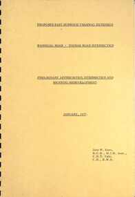
Document - Report, John Knee, "Warragul Road - Toorak Road Intersection", Jan. 1977
... Looks at the intersection, how the shopping centre could be accessed, possible Mall development, residential issues, passenger facilities and pedestrian capacity. Includes a number of possible access routes for the area. ...Looks at the intersection, how the shopping centre could be accessed, possible Mall development, residential issues, passenger facilities and pedestrian capacity. Includes a number of possible access routes for the area. ...Report - "proposed East Burwood Tramway Extension - Warragul Road - Toorak Road Intersection - Preliminary Appreciation intersection and shopping redevelopment - Jan. 1977". Prepared by John W Knee for the MMTB and others. Looks at the intersection, how the shopping centre could be accessed, possible Mall development, residential issues, passenger facilities and pedestrian capacity. Includes a number of possible access routes for the area. None were applied when the tram line was extended.Yields information about a consideration for the extension of the Toorak Road line to East Burwood in 1977.Comb bound report with clear plastic covers, brown covers, 17 A4 pagesmmtb, east burwood, toorak road, warragul road, new tramways, john knee -
 Emerald Museum & Nobelius Heritage Park
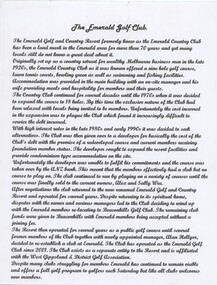
Essay - Local history typescript, The Emerald Golf Club, c.1990s
... It offered accommodation and dining, a nine-hole golf course, tennis courts, a bowling green as well as swimming and fishing facilities. By the 1970s the exclusive nature of the club had been relaxed and the golf course expanded. ...It offered accommodation and dining, a nine-hole golf course, tennis courts, a bowling green as well as swimming and fishing facilities. By the 1970s the exclusive nature of the club had been relaxed and the golf course expanded. ...The Emerald Country Club was originally set up as a country retreat for the wealthy in the late 1920s. It was modelled on American country clubs and it was situated on land formerly owned by the Gembrook Nurseries. It offered accommodation and dining, a nine-hole golf course, tennis courts, a bowling green as well as swimming and fishing facilities. By the 1970s the exclusive nature of the club had been relaxed and the golf course expanded. Its complex history since then is detailed in the typescript. This short essay describes the history of golf in Emerald.A typed A4 page entitled: 'The Emerald Golf Club'. The font is of a cursive style.emerald country club, gembrook nurseries, golf, emerald golf club -
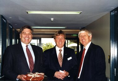 Vision Australia
Photograph - Image, Rob Knowles visit to Kelaston, 1997
... As part of it's Centenary Appeal, the Association for the Blind wished to upgrade it's facilities at Kelaston. In these images, the Minister for Aged Care (Rob Knowles) visited the site and viewed the proposed redevelopment....As part of it's Centenary Appeal, the Association for the Blind wished to upgrade it's facilities at Kelaston. In these images, the Minister for Aged Care (Rob Knowles) visited the site and viewed the proposed redevelopment. ...039 - Rex Hollioake, appeal chairman, shows Minister for Health and Aged Care Rob Knowles and another man the plans for a redeveloped Kelaston. 043 - Minister for Health Rob Knowles with Terry Fraser, Kelaston manager, and John Cook, Association for the Blind CEO. As part of it's Centenary Appeal, the Association for the Blind wished to upgrade it's facilities at Kelaston. In these images, the Minister for Aged Care (Rob Knowles) visited the site and viewed the proposed redevelopment.2 x colour photographs of visit by Health Minister Rob Knowlesjohn cook, association for the blind, kelaston home (ballarat), rex hollioake, rob knowles, terry fraser -
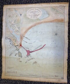 Warrnambool and District Historical Society Inc.
Map - Warrnambool Port 1879, 1879
... The port facilities in Warrnambool Bay were in constant use from the first years of Warrnambool’s settlement but there were also difficulties for the shipping trade – a small and unsafe anchorage, the lack of loading facilities and little natural protection from the southerly gales. ...Warrnambool and District Historical Society Inc. 2 Gilles Street (south of Merri St) Warrnambool great-ocean-road The port facilities in Warrnambool Bay were in constant use from the first years of Warrnambool’s settlement but there were also difficulties for the shipping trade – a small and unsafe anchorage, the lack of loading facilities and little natural protection from the southerly gales. ...The port facilities in Warrnambool Bay were in constant use from the first years of Warrnambool’s settlement but there were also difficulties for the shipping trade – a small and unsafe anchorage, the lack of loading facilities and little natural protection from the southerly gales. From the 1870s on there was local agitation for some sort of Breakwater to be built and an Andrew Kerr design was approved by the Warrnambool Council but no funds were made available from the Victorian Government. Throughout the 1870s the building of a Breakwater was a major political issue in the district with preliminary work being funded and started in 1874. In 1879 the Government agreed to a further inspection of the area and an official report. Sir John Coode (1816-1892) was commissioned to make this report. He had come to Australia in 1872 to advise on harbour construction. Coode recommended a 1800 feet long Breakwater and wharf connected to the shore and it was this proposal that the plan described herein and drawn up in 1879 was to accompany. The original plan was eventually modified because of the cost and a Breakwater was completed in 1890 under the direction of the engineer, Arthur Dudley Dobson, with extensions early in the 20th century. This plan is of great interest as it shows in simple graphic form the original plans proposed by Sir John Coode for the Warrnambool Breakwater. It is therefore of great historical importance. The Breakwater was not the maritime success that it was hoped it would be but it is today a significant feature of our foreshore. This is a Plan drawn up in 1879 by Victorian Harbours to accompany Sir John Coode’s Report on the proposed Warrnambool Breakwater. The chart detail is hand-drawn and hand-tinted on canvas with the names of places, geographical and marine features and local points of interest added in print. The edges of the chart are rubbed and the chart is somewhat faded and dirty but the main colours of red, green and brown are still clearly discernible. The title of the plan is printed in an oval inset at the top of the chart. The plan shows two possible Breakwater designs, one from the Borough Surveyor (Andrew Kerr?) and one from Sir John Coode.Victorian Harbours Warrnambool Plan to accompany Sir John Coode’s report Dated 28th Feby 1879 warrnambool breakwater, andrew kerr, sir john coode, arthur dudley dobson, warrnambool, warrnambool harbour, warrnambool history, warrnambool beach -
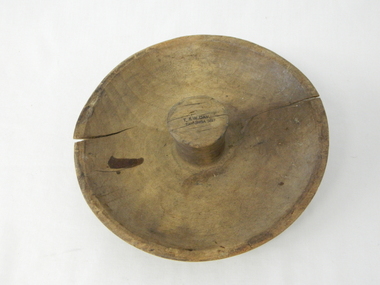 Kiewa Valley Historical Society
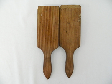
Mould Butter, unknown, post 1967
... The 1960's was a time when facilities especially goods and services started to improve drastically. ...The 1960's was a time when facilities especially goods and services started to improve drastically. ...This butter mould/pat may have been manufactured post 1967(year post codes appeared in Australia) however the post code was only stamped on after it was machined. This type of butter mould was used by rural families to fashion home/farm made butter. This period was in most rural regions a time of self sufficiency where any domestic type implement which could be fashioned by the family would be crafted with skill. Shopping for goods required catalogues from stores located in major rural towns and cities and involved lengthy waiting times. Travelling to and from these specialised stores was not pleasant due to the relatively poor quality of the roads and the lengthy times taken. The small general stores in the Kiewa Valley could not cater for all the needs of the valley. The 1960's was a time when facilities especially goods and services started to improve drastically. The S.E.C. of Victoria with its Kiewa Hydro Electricity Scheme provided not only an improvement of facilities in the valley but also a increase in the population. This increase resulted in a greater demand for local produce. This item is one of many domestic food processing implements used by Kiewa Valley households in the mid 1900s, whether on the farm or in the small towns and hamlets. Self sufficiency was the key to survival during these early times. Where ever possible supplies from within the valley were preferred to that brought in by travelling salesmen or traders. This butter mould and butter pat was commonly used to fashion "home" made butter throughout the valley and in some cases supplied to "outside" regional towns. Although this method of production was phased out by better access to goods from nearby cities the revival of the good organic home grown produce in the 1980s saw a greater demand of this type of farm based produce.This well crafted circular wooden butter mould could also be used as a butter pat.The handle in the middle of the mould was not added after the crafting but has been fashioned from the initial block of wood when the bowl was crafted. The bowl structure has a rim around the edge.The top of the handle has an ink stamp "T. & W. Dav" on the top line and "Tawonga 3697" underneath.domestic food preparation, wooden butter pat, butter mould circular, dairy industry -
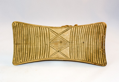 Kiewa Valley Historical Society
Pat Butter Profiler, Circa 1950s
... The 1960's was a time when facilities especially goods and services started to improve drastically. ...The 1960's was a time when facilities especially goods and services started to improve drastically. ...This butter pat profiler may have been manufactured post 1967(year post codes appeared in Australia) however the post code was only stamped on after it was machined. This type of butter mould was used by rural families to fashion home/farm made butter. This period was in most rural regions a time of self sufficiency where any domestic type implement which could be fashioned by the family would be crafted with skill. Shopping for goods required catalogues from stores located in major rural towns and cities and involved lengthy waiting times. Travelling to and from these specialised stores was not pleasant due to the relatively poor quality of the roads and the lengthy times taken. The small general stores in the Kiewa Valley could not cater for all the needs of the valley. The 1960's was a time when facilities especially goods and services started to improve drastically. The S.E.C. of Victoria with its Kiewa Hydro Electricity Scheme provided not only an improvement of facilities in the valley but also a increase in the population. This increase resulted in a greater demand for local produce.This item is one of many domestic food processing implements used by Kiewa Valley households in the mid 1900s, whether on the farm or in the small towns and hamlets. Self sufficiency was the key to survival during these early times. Where ever possible supplies from within the valley were preferred to that brought in by travelling salesmen or traders. This butter mould and butter pat was commonly used to fashion "home" made butter throughout the valley and in some cases supplied to "outside" regional towns. Although this method of production was phased out by better access to goods from nearby cities the revival of the good organic home grown produce in the 1980s saw a greater demand of this type of farm based produce.This butter Pat/Profiler has on its base two patterns. On each end it has horizontal grooves cut into the wood which produce distinct lines onto the surface of the butter. between these grooves there is a section of two double lines crossing in the middle and separated by eleven horizontal lines The base has an elongated rectangular shape. The upper body has been sanded into a smooth convex shaped form where a wooden circular hand grip has been fashioned.On the top of the hand grip is stamped in black print"T. & W. Davies" and under this"TAWONGA 3697"domestic food preparation, wooden butter pat, butter mould circular, dairy industry -
 Kiewa Valley Historical Society
Pat Butter, Circa 1950
... The 1960's was a time when facilities especially goods and services started to improve drastically. ...The 1960's was a time when facilities especially goods and services started to improve drastically. ...This butter pat profiler may have been manufactured post 1967 (year post codes appeared in Australia) however the post code was only stamped on after it was machined. This type of butter mould was used by rural families to fashion home/farm made butter. This period was in most rural regions a time of self sufficiency where any domestic type implement which could be fashioned by the family would be crafted with skill. Shopping for goods required catalogues from stores located in major rural towns and cities and involved lengthy waiting times. Travelling to and from these specialised stores was not pleasant due to the relatively poor quality of the roads and the lengthy times taken. The small general stores in the Kiewa Valley could not cater for all the needs of the valley. The 1960's was a time when facilities especially goods and services started to improve drastically. The S.E.C. of Victoria with its Kiewa Hydro Electricity Scheme provided not only an improvement of facilities in the valley but also a increase in the population. This increase resulted in a greater demand for local produce.This item is one of many domestic food processing implements used by Kiewa Valley households in the mid 1900s, whether on the farm or in the small towns and hamlets. Self sufficiency was the key to survival during these early times. Where ever possible supplies from within the valley were preferred to that brought in by travelling salesmen or traders. This butter mould and butter pat was commonly used to fashion "home" made butter throughout the valley and in some cases supplied to "outside" regional towns. Although this method of production was phased out by better access to goods from nearby cities the revival of the good organic home grown produce in the 1980s saw a greater demand of this type of farm based produce.This butter pat is one of two,see KVHS 0071 (B). It has been crafted from wood. One side has grooves running from the handle to the square shaped bottom. These grooves would stop the wet butter from clinging to the pat. The top side of the pat has been bevelled on both sides and the bottom edge. The hand grip is flat and curved to allow for a comfortable hold.domestic food preparation, wooden butter pat, butter mould circular, dairy industry, butter -
 Kiewa Valley Historical Society
Pat Butter Profiler, Circa 1950
... The 1960's was a time when facilities especially goods and services started to improve drastically. ...The 1960's was a time when facilities especially goods and services started to improve drastically. ...This butter pat profiler may have been manufactured post 1967(year post codes appeared in Australia) however the post code was only stamped on after it was machined. This type of butter mould was used by rural families to fashion home/farm made butter. This period was in most rural regions a time of self sufficiency where any domestic type implement which could be fashioned by the family would be crafted with skill. Shopping for goods required catalogues from stores located in major rural towns and cities and involved lengthy waiting times. Travelling to and from these specialised stores was not pleasant due to the relatively poor quality of the roads and the lengthy times taken. The small general stores in the Kiewa Valley could not cater for all the needs of the valley. The 1960's was a time when facilities especially goods and services started to improve drastically. The S.E.C. of Victoria with its Kiewa Hydro Electricity Scheme provided not only an improvement of facilities in the valley but also a increase in the population. This increase resulted in a greater demand for local produce.This item is one of many domestic food processing implements used by Kiewa Valley households in the mid 1900s, whether on the farm or in the small towns and hamlets. Self sufficiency was the key to survival during these early times. Where ever possible supplies from within the valley were preferred to that brought in by travelling salesmen or traders. This butter mould and butter pat was commonly used to fashion "home" made butter throughout the valley and in some cases supplied to "outside" regional towns. Although this method of production was phased out by better access to goods from nearby cities the revival of the good organic home grown produce in the 1980s saw a greater demand of this type of farm based produce.This butter pat is one of two,see KVHS 0071 (A). It has been crafted from wood. One side has grooves running from the handle to the square shaped bottom. These grooves would stop the wet butter from clinging to the pat. The top side of the pat has been bevelled on both sides and the bottom edge. The hand grip is flat and curved to allow for a comfortable hold.domestic food preparation, wooden butter pat, butter mould circular, dairy industry -
 Kiewa Valley Historical Society
Posters - "Tawonga Remembers" x 5, 2016
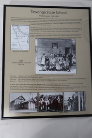
... Tawonga consists of essential amenities including a store, school, post office, butter factory, sporting facilities, hall and hotel. Activities involved sport, social get togethers eg. dances, fund raising, CWA etc....Tawonga consists of essential amenities including a store, school, post office, butter factory, sporting facilities, hall and hotel. Activities involved sport, social get togethers eg. dances, fund raising, CWA etc. ...The town of Tawonga is in the Kiewa Valley surrounded by farmland. It is adjacent to Mt Beauty (built from 1946), an SECV town built for workers on the SECV's Kiewa Hydro Electric Scheme, which was being constructed from 1911-1961. Tawonga consists of essential amenities including a store, school, post office, butter factory, sporting facilities, hall and hotel. Activities involved sport, social get togethers eg. dances, fund raising, CWA etc.The posters are a collection of historical photos, documentation and information re the history of the town of Tawonga, which is the centre of a farming community in the Kiewa Valley.Posters framed with thin black plastic strip, covered by glass. Each one has a title re "Tawonga Remembers" and includes print and photos in black and white. These have a beige background. 1. Tawonga 1907; 2. Tawonga 1962; 3. Tawonga State School- 1880-1929; 4. Tawonga Primary School -1960; 5. The Beginning of Change: 1930-1970tawonga, photos of early tawonga, kiewa valley, tawonga remembers, tawonga school -
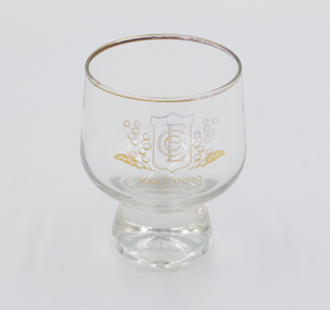 Emerald Museum & Nobelius Heritage Park
Functional object - Drinking glass with short stem, c.1980s-1990s
... Its profile included a golf club and a bowls club serviced by a club house that provided meeting and eating facilities. It played an important role in the local community as it attracted state, national and international visitors for special sporting events and regular recreation. ...Its profile included a golf club and a bowls club serviced by a club house that provided meeting and eating facilities. It played an important role in the local community as it attracted state, national and international visitors for special sporting events and regular recreation. ...The Emerald Country Club operated from the late 1920s until around 2010 on the northern section of the land previously occupied by Gembrook Nurseries. Its profile included a golf club and a bowls club serviced by a club house that provided meeting and eating facilities. It played an important role in the local community as it attracted state, national and international visitors for special sporting events and regular recreation. This was awarded to Doreen Ball for success in a bowls competition between 1983 and 1995.This glass is an artifact from the Emerald Country Club which was an iconic part of the Emerald community for around 90 years. It contributed to and played a major role in the social and sporting profile of the district.One clear drinking glass, squat, round shape, gold-rimmed with a short stem, awarded as a prize by the Emerald Country Club. "BOWLS TROPHY" with associated ECC logo on the bowlemerald, emerald country club, emerald country club and golf course, sports, trophy, glassware -
 Glen Eira Historical Society
Article - Glen Huntly Park
... This file contains two items. 1/ An article from the CAULFIELD CONTACT on the history of Glen Huntly Park and its facilities, dated Jan/ Feb 1992. It includes 2 black and white photos: one of Cr Nicholas Gold and one of Mr Victor Townsend (Secretary/Treasurer for Glen Huntly Park Committee of Management) in front of the new pavilion. 2/ Two of the same original colour photographs of the pavilion at Glen Huntly Park, date unknown....Glen Eira Historical Society 965 Glen Huntly Rd Caulfield VIC 3162 melbourne This file contains two items. 1/ An article from the CAULFIELD CONTACT on the history of Glen Huntly Park and its facilities, dated Jan/ Feb 1992. It includes 2 black and white photos: one of Cr Nicholas Gold and one of Mr Victor Townsend (Secretary/Treasurer for Glen Huntly Park Committee of Management) in front of the new pavilion. 2/ Two of the same original colour photographs of the pavilion at Glen Huntly Park, date unknown. ...This file contains two items. 1/ An article from the CAULFIELD CONTACT on the history of Glen Huntly Park and its facilities, dated Jan/ Feb 1992. It includes 2 black and white photos: one of Cr Nicholas Gold and one of Mr Victor Townsend (Secretary/Treasurer for Glen Huntly Park Committee of Management) in front of the new pavilion. 2/ Two of the same original colour photographs of the pavilion at Glen Huntly Park, date unknown.glen huntly park, e. e. gunn park, city of caulfield, caulfield, glen huntly, football clubs, cricket clubs, caulfield north ward, caulfield racecourse, neerim road caulfield, booran road caulfield, parks, reserves, glen huntly sports ground, gold nicholas cr, townsend victor, clyde holding mp, pavilions, barbecues, picnic spots, playgrounds, tennis courts, north caulfield/ glen huntly cricket club, glen huntly amateur football club, the bloods football club, australian rules football, sports establishments, recreations establishments, sports grounds, sports, recreations, sporting clubs, clubs, associations, football clubs, tennis clubs, cricket clubs, leisure, cultural events, cultural activities, ovals, playing fields