Showing 2626 items
matching house plan
-
 Port Melbourne Historical & Preservation Society
Plan - Toll bar, house and closet, Sandridge, Charles Clay?, Borough Surveyor, 1860s - 1870s
... Street) Port Melbourne melbourne Toll bar, house and closet ...Plan and elevation for Borough of Sandridge toll bar, house and closet, hand drawn and coloured 1860s-70s. Master copy.Signed by Chas. Clay, Suveyor and John L. Forrester (?) and witnessed bt Thomas R. Warren (?).built environment - civic, charles clay, thomas peek warren, john l forrester -
Port Melbourne Historical & Preservation Society
Plan - Weighbridge house, Sandridge, Charles Clay, Borough Surveyor, c. 1893
... Plan Plan of design for a house to the weighbridge for Borough ...Plan of design for a house to the weighbridge for Borough of Sandridge, date unknownSigned by Chas. Clay and Irwin Walter Brinton (?) near bottom right hand corner (Borough Surveyors Office)built environment - civic, charles clay, irwin walter brinton -
Port Melbourne Historical & Preservation Society
Plan - Housing Commission Victoria, Erection of State houses, Fishermen's Bend, 1930s
... , Erection of State houses, Fishermen's Bend Plan Housing Commission ...Housing Commission Victoria. Plan of area at Fishermen's Bend Port Melbourne, to be used for erection of State houses. late1930sNotations in Pencil.town planning, garden city, fishermans bend -
Port Melbourne Historical & Preservation Society
Plan - Handcoloured identification of wood and brick buildings, hotels and lanes on copy of a section of MMBW map, 1930s
Given to Peter Libbis, who hand ocloured legend etc. while researching his house and family, then donated to society in 1997.Photocopy of MMBW plan 326 - block between Stokes and Princes, Rouse and Graham. Colour coded for brick or wood builidngs, lanes marked in green and four hotels indicated.As abovebuilt environment, hotels, religion - roman catholic church (st josephs), peter libbis -
 Monbulk RSL Sub Branch
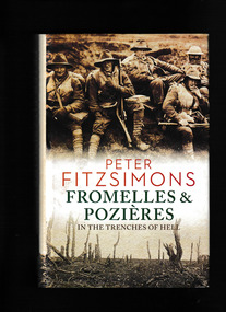
Book, Peter Fitzsimons, Fromelles and Pozières : in the trenches of hell, 2015
In the Trenches of Hell On 19 July 1916, 7000 Australian soldiers - in the first major action of the AIF on the Western Front - attacked entrenched German positions at Fromelles in northern France. By the next day, there were over 5500 casualties, including nearly 2000 dead - a bloodbath that the Australian War Memorial describes as 'the worst 24 hours in Australia's entire history. Just days later, three Australian Divisions attacked German positions at nearby Pozi�res, and over the next six weeks they suffered another 23,000 casualties. Of that bitter battle, the great Australian war correspondent Charles Bean would write, 'The field of Pozi�res is more consecrated by Australian fighting and more hallowed by Australian blood than any field which has ever existed . . .' Yet the sad truth is that, nearly a century on from those battles, Australians know only a fraction of what occurred. This book brings the battles back to life and puts the reader in the moment, illustrating both the heroism displayed and the insanity of the British plan. With his extraordinary vigour and commitment to research, Peter FitzSimons shows why this is a story about which all Australians can be proud. And angry.Index, bibliography, notes, ill (maps), p.816.In the Trenches of Hell On 19 July 1916, 7000 Australian soldiers - in the first major action of the AIF on the Western Front - attacked entrenched German positions at Fromelles in northern France. By the next day, there were over 5500 casualties, including nearly 2000 dead - a bloodbath that the Australian War Memorial describes as 'the worst 24 hours in Australia's entire history. Just days later, three Australian Divisions attacked German positions at nearby Pozi�res, and over the next six weeks they suffered another 23,000 casualties. Of that bitter battle, the great Australian war correspondent Charles Bean would write, 'The field of Pozi�res is more consecrated by Australian fighting and more hallowed by Australian blood than any field which has ever existed . . .' Yet the sad truth is that, nearly a century on from those battles, Australians know only a fraction of what occurred. This book brings the battles back to life and puts the reader in the moment, illustrating both the heroism displayed and the insanity of the British plan. With his extraordinary vigour and commitment to research, Peter FitzSimons shows why this is a story about which all Australians can be proud. And angry.world war 1914-1918 - campaigns - western front, world war 1914-1918 - australian participation - fromelles and pozieres -
 Monbulk RSL Sub Branch
Book, Hermes House, The ultimate illustrated history of World War II : an authoritative account of one of the deadliest conflicts in human history with analysis of decisive encounters and landmark engagements, 2009
This history of the war has commentary on the political and economic factors leading to the conflict, the key turning points of the war and the impact of new technologies. Colour campaign maps and battle plans complement the description of every major battle on land and at sea, along with analysis of the success and failure of the various military strategies. It focuses on the key military figures who shaped the course of the war and describes all of the most successful weapons of war, with a specification box on each weapon providing key technical details.Index, ill, maps, p.256.This history of the war has commentary on the political and economic factors leading to the conflict, the key turning points of the war and the impact of new technologies. Colour campaign maps and battle plans complement the description of every major battle on land and at sea, along with analysis of the success and failure of the various military strategies. It focuses on the key military figures who shaped the course of the war and describes all of the most successful weapons of war, with a specification box on each weapon providing key technical details.world war 1939-1945 - history, world war 1939-1945 - campaigns -
 Ithacan Historical Society
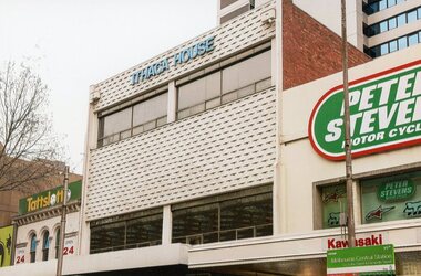
Photograph, Ithaca House, 2016
Ithaca House located at 329 Elizabeth Street Melbourne has been the site of the clubrooms of the Ithacan Philanthropic Society since 1958. Over the decades the club rooms have served as a meeting place and a venue for many social, cultural and fundraising activities. Prior to the building of Ithaca House, the clubrooms been located at Michael's Building, corner Lonsdale and Elizabeth Streets since 1917.In 1956, the Ithacans of Melbourne purchased a site, formerly two shops, at 329-335 Elizabeth Street for £35,000, with a view to building their own club rooms. A three storey building, a stone's throw from the old Michael's clubrooms, was finally erected in 1958 at a cost of £25,000. This was achieved by capital raising from the membership in the form of non-redeemable £10 and £50 debentures (1957-58). Plans were drawn up by the Australian born and newly qualified Ithacan architect, Nicholas Sofarnos (Sofianos). The then President Eustathios (Stathis) Vlassopoulos was key driver of the project. A colour photograph of the front upper stories of Ithaca House -
 Coal Creek Community Park & Museum
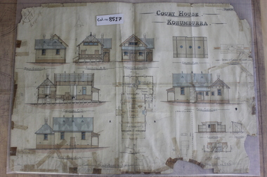
Korumburra Courthouse Plan, Court House. Korumburra, 27-04-1899
... Korumburra gippsland Korumburra Courthouse Plan Court House ...8517.1 - Architectural/Design plan of the Korumburra court house and attendant "Fuel Shed". Colour painted. Various notes and marks in pensil and ink; a lot of tapoe holding it together. -
 Cockatoo History & Heritage Group
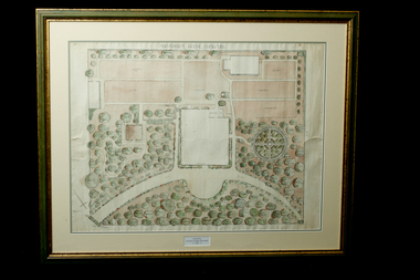
Landscape Plan, Providence House Cockatoo, 1930's
... -and-the-dandenong-ranges Landscape Plan Providence House Cockatoo Framed ...The Presbyterian Church owned three lots of land bounded by Pakenham Road and the northern side of Dorchester Road, between 1927 and 1964. Providence House opened in 1927 as a peaceful country rest home for “tired mothers” from the inner suburbs, and their children. It was also used, at different times, for kindergarten groups and in 1955 for a girls Bible Class for Easter “studies, fun and fellowship.”Cockatoo had several guest houses which took paying guests. Providence House did not charge fees, but is the best-documented of the large houses which provided accommodation.Framed landscape design plan under glass, with detailed plant listings. Original watercolourDonated by Victoria & Digby Newcombe 2003presbyterian church, rest home, landscape plan, garden design, cockatoo victoria, providence house, black n.c, -
Moorabbin Air Museum
Administrative record (item) - Documents Relating to a CAC Designed and Produced Housing Project, Housing Project - Myer House
Includes floor plans and other documents relating to the project -
 Eltham District Historical Society Inc
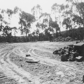
Work on paper (item) - Photograph, 2 Metery Road, Eltham South
Robert and Ada Zull built an Alistair Knox designed house at 2 (lot 8) Metery Road, Eltham, a one acre property for their family of five in the mid 1960s. The cleared block is an expanse of dirt with wheel tracks, with trees and bush in the background and piles of rocks on the right hand side. Susan Bennett, nee Zull's reminiscences are published in EDHS Newsletter, February and April 2020. ".. the block was big.. Building the house was slow going. The plans had to be discussed, then drawn up, finance found, council permits obtained and labourers engaged. " This series of photographs together with the account of personal remiscences provide a unique document of the construction of an Alistair Knox designed home. Knox was a pioneer in the use of mudbricks and recycled materials and is significant to his contribution of this style of architecture in Eltham and the wider Shire of Nillumbik.zull family, clearing, eltham south, 2 metery road, alistair knox -
 Eltham District Historical Society Inc
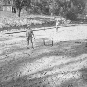
Work on paper (item) - Photograph, 2 Metery Road, Eltham South
Robert and Ada Zull built an Alistair Knox designed house at 2 (lot 8) Metery Road, Eltham, a one acre property for their family of five in the mid 1960s. The form of the house is laid out on the cleared block. There was a dam at the bottom of the block. Susan Bennett, nee Zull's reminiscences are published in EDHS Newsletter, February and April 2020. ".. the block was big.. Building the house was slow going. The plans had to be discussed, then drawn up, finance found, council permits obtained and labourers engaged. " This series of photographs together with the account of personal remiscences provide a unique document of the construction of an Alistair Knox designed home. Knox was a pioneer in the use of mudbricks and recycled materials and is significant to his contribution of this style of architecture in Eltham and the wider Shire of Nillumbik.zull family, clearing, eltham south, 2 metery road, alistair knox, bow and arrow -
 Eltham District Historical Society Inc
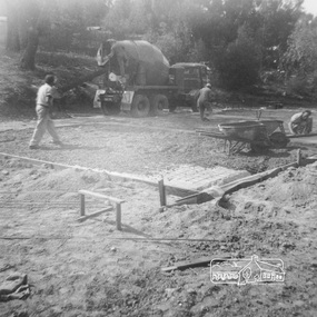
Work on paper (item) - Photograph, 2 Metery Road, Eltham South
Robert and Ada Zull built an Alistair Knox designed house at 2 (lot 8) Metery Road, Eltham, a one acre property for their family of five in the mid 1960s. Concrete footings are poured. The house had a concrete floor. Susan Bennett, nee Zull's reminiscences are published in EDHS Newsletter, February and April 2020. ".. the block was big.. Building the house was slow going. The plans had to be discussed, then drawn up, finance found, council permits obtained and labourers engaged. " This series of photographs together with the account of personal remiscences provide a unique document of the construction of an Alistair Knox designed home. Knox was a pioneer in the use of mudbricks and recycled materials and is significant to his contribution of this style of architecture in Eltham and the wider Shire of Nillumbik.zull family, eltham south, 2 metery road, alistair knox, bow and arrow, footings, concrete, concrete mixer -
 Eltham District Historical Society Inc
Work on paper (item) - Photograph, 2 Metery Road, Eltham South
Robert and Ada Zull built an Alistair Knox designed house at 2 (lot 8) Metery Road, Eltham, a one acre property for their family of five in the mid 1960s. This series of photographs show the bush block before construction, concrete footings and base being poured and the timber frame takes shape. The house had a concrete floor. Susan Bennett, nee Zull's reminiscences are published in EDHS Newsletter, February and April 2020. ".. the block was big.. Building the house was slow going. The plans had to be discussed, then drawn up, finance found, council permits obtained and labourers engaged. "This series of photographs together with the account of personal remiscences provide a unique document of the construction of an Alistair Knox designed home. Knox was a pioneer in the use of mudbricks and recycled materials and is significant to his contribution of this style of architecture in Eltham and the wider Shire of Nillumbik.zull family, eltham south, 2 metery road, alistair knox, footings, concrete, concrete mixer, frame, bush block, fj holden standard sedan -
 Eltham District Historical Society Inc
Film - Video (DVD), Nillumbik Shire Council, Edendale Farm Community Environment Centre: History, c.2009
EDENDALE FARM Edendale Farm is Nillumbik Shire Council's environment centre situated in Gastons Road, Eltham between the railway and the Diamond Creek. The homestead on the property was built in 1896 and is of historical significance, being the subject of a Heritage Overlay under the Nillumbik Planning Scheme. The Edendale property was originally part of an extensive land purchase in 1852 from the Crown by pioneer Eltham farmer Henry Stooke. He initially purchased 51 acres and later expanded his holdings by purchasing another three adjacent Crown allotments extending northerly from Josiah Holloway's Little Eltham subdivision. Despite clearing the land, Stooke did not build on this property, choosing to live on his property "Rosehill" at Lower Plenty. In 1896 Thomas Cool, Club Manager of the Victoria Coffee Palace in Melbourne purchased 7 acres of the original Stooke land and built the house now known as Edendale. Cool did not farm the land, instead using it as a gentleman’s residence, retiring to Eltham at weekends. In 1918 he purchased an additional 7 acres but in 1919 he sold the property. Later owners included J.W. Cox, the Gaston family and D. Mummery. In the 1980s the Eltham Shire Council purchased the site for use as a Council depot, but this use did not proceed. Subsequently, it was used as the Council pound. The Edendale Farm Pet Education and Retention Centre was established in the summer of 1988/1989 and was set up to replace the existing dog kennels with a high standard pet retention centre. The design style of the building was established to compliment the features of the existing house. It was equipped with 10 retention pens, a veterinary room and a pet education area where school children and other interested parties learnt about pet care procedures. It was later developed into a community farm and was run by an advisory committee and in 2000 it became an Environment Centre. In early 2006 an advisory committee was established for the development of a master plan for future development at Edendale Farm. The committee included Russell Yeoman, a former long-time shire planner and founding member of the Eltham District Historical Society. At the time of filming the Master Plan and future for Edendale was about continuing to develop Edendale as a centre of environment learning and looking at expanding displays and school program, running a lot more of life-long learning and workshops around sustainable living.edendale community farm, eltham, gastons homestead, gastons road, shire of nillumbik, video recording -
 Eltham District Historical Society Inc
Document - Building Plan, J.M. Harcourt, 22 Peter Street, Eltham, c.1946
Pise or Adobe Brick Cottage for Mr D. Sawer in Peter St., Eltham Design and drawings by J.M. Harcourt, Clay Nuneham, Eltham. The cottage at present day 22 Peter Street was built circa 1946. Also Drawing of planned carport and future extension for 22 Peter Street, Eltham22 peter street, building plans, clay nuneham, d. sawer, eltham, j.m. harcourt design, adobe house, j.m. harcourt designc.1946, pise house -
 Eltham District Historical Society Inc
Photograph - Digital Photograph, Alan King, Allwood House, Hurstbridge, 16 April 2008
Allwood - built in 1894 by Henry Hurst’s relatives, stands near the site of his house, which was demolisherd in the 1940s. Until 1924 Hurstbridge was known as Allwood. The building, one of the district's oldest is situated back from the corner of Arthurs Creek Road and Main Road. Covered under Heritage Overlay, Nillumbik Planning Scheme Published: Nillumbik Now and Then / Marguerite Marshall 2008; photographs Alan King with Marguerite Marshall.; p17This collection of almost 130 photos about places and people within the Shire of Nillumbik, an urban and rural municipality in Melbourne's north, contributes to an understanding of the history of the Shire. Published in 2008 immediately prior to the Black Saturday bushfires of February 7, 2009, it documents sites that were impacted, and in some cases destroyed by the fires. It includes photographs taken especially for the publication, creating a unique time capsule representing the Shire in the early 21st century. It remains the most recent comprehenesive publication devoted to the Shire's history connecting local residents to the past. nillumbik now and then (marshall-king) collection, hurstbridge, henry hurst, allwood house -
 Eltham District Historical Society Inc
Photograph - Digital Photograph, Alan King, Sweeney's Cottage, Sweeneys Lane, Eltham, 30 January 2008
Part of the original cottage named Culla Hill built by Thomas Sweeney (a former convict) remains as a small section of today’s house. Covered under Heritage Overlay, Nillumbik Planning Scheme National Estate National Trust of Australia (Victoria) Local Sifgnificance Published: Nillumbik Now and Then / Marguerite Marshall 2008; photographs Alan King with Marguerite Marshall.; p19This collection of almost 130 photos about places and people within the Shire of Nillumbik, an urban and rural municipality in Melbourne's north, contributes to an understanding of the history of the Shire. Published in 2008 immediately prior to the Black Saturday bushfires of February 7, 2009, it documents sites that were impacted, and in some cases destroyed by the fires. It includes photographs taken especially for the publication, creating a unique time capsule representing the Shire in the early 21st century. It remains the most recent comprehenesive publication devoted to the Shire's history connecting local residents to the past. nillumbik now and then (marshall-king) collection, culla hill, eltham, sweeney's cottage, sweeneys lane, thomas sweeney -
 Eltham District Historical Society Inc
Photograph - Digital Photograph, Marguerite Marshall, Former Head Teacher's residence, Eltham Primary School, Dalton Street, Eltham, 7 September 2008
Built in 1891 for Head Teacher John Brown. His predecessor and the school's first Head Teacher, John Clark, lived in his own house 'Shoestring' in Metery Road, adjacent to the school. At the time of this photograph, the building was being used for before and after school care. Its present-day (2023) use is for school administration offices. Covered under Heritage Overlay, Nillumbik Planning Scheme. Published: Nillumbik Now and Then / Marguerite Marshall 2008; photographs Alan King with Marguerite Marshall.; p49This collection of almost 130 photos about places and people within the Shire of Nillumbik, an urban and rural municipality in Melbourne's north, contributes to an understanding of the history of the Shire. Published in 2008 immediately prior to the Black Saturday bushfires of February 7, 2009, it documents sites that were impacted, and in some cases destroyed by the fires. It includes photographs taken especially for the publication, creating a unique time capsule representing the Shire in the early 21st century. It remains the most recent comprehenesive publication devoted to the Shire's history connecting local residents to the past. nillumbik now and then (marshall-king) collection, dalton street, eltham, eltham primary school, headmaster's residence, main road, state school no. 209 -
 Eltham District Historical Society Inc
Photograph - Digital Photograph, Marguerite Marshall, Souter House, 23 Falkiner Street, Eltham, 20 June 2008
Originally built in the 1850s by Charles Souter from earth excavated from his property. It was a forerunner for a building style that was later to be synonymous with Eltham. The house is historically significant as the oldest mud brick building in the Shire of Nillumbik, as one of less than half a dozen buildings from the 1850s that survive in the Shire. It underwent several additions and alterations between c.1950s-1980s. It is also significant for its associations with Mervyn Skipper from the well-known Eltham family who was one of the founders of the artist's colony at Montsalvat. The house is architecturally significant because its north section was designed by the noted 'Eltham-style' architect, Alistair Knox, and the two long Oregon beams supporting the main floor were added by the noted 'Eltham-style' builder, Horrie Judd who built the southern room. A onetime tenant in the house, Judd built many Eltham houses and was a major builder of Montsalvat. The 1934 flood destroyed the south wall and the house remained unoccupied for some time. Sonia Skipper, one of Montsalvat’s builders who also worked for Alistair Knox oversaw rebuilding it. She employed landscape designer Gordon Ford, artist Peter Glass and Tim Burstall. The house originally had a cellar for making and storing wine, reputedly the first made in the district according to Alistair Knox in his book ‘We are what we stand on’ (p33). Water would seep into the cellar so Sonia’s father and then owner of the house, Mervyn Skipper bulldozed a channel outside to divert it. The Brocksopp family purchased the house in 1950 and added an outside door to the cellar and converted it into a gallery. Covered under Heritage Overlay, Nillumbik Planning Scheme. Published: Nillumbik Now and Then / Marguerite Marshall 2008; photographs Alan King with Marguerite Marshall.; p51This collection of almost 130 photos about places and people within the Shire of Nillumbik, an urban and rural municipality in Melbourne's north, contributes to an understanding of the history of the Shire. Published in 2008 immediately prior to the Black Saturday bushfires of February 7, 2009, it documents sites that were impacted, and in some cases destroyed by the fires. It includes photographs taken especially for the publication, creating a unique time capsule representing the Shire in the early 21st century. It remains the most recent comprehenesive publication devoted to the Shire's history connecting local residents to the past. nillumbik now and then (marshall-king) collection, eltham, falkiner street, mud brick building, mudbrick houses, souter house -
 Eltham District Historical Society Inc
Photograph - Digital Photograph, Alan King, Eltham Living and Learning Centre, 26 January 2008
In 1857, tanner John Pearson purchased three and a half acres of land in Little Eltham, at the western end of Pitt Street, with a 70-foot frontage to Maria Street (Main Road) and stretching down to the Diamond Creek for £100. He contracted Benjamin Oliver Wallis to build house for him. Wallis, a mason by trade who originated from the Cornish village of Newlyn, migrated to Melbourne in 1853 and was shortly engaged by Richard Warren to build the Eltham Hotel, which opened in 1854. When Warren fell into financial difficulty in 1858, Wallis purchased the hotel. That same year, Pearson constructed a tannery below the house with access to the water in the Diamond Creek. When Pearson became bankrupt in 1867, Wallis similarly acquired the house from Pearson’s creditors in 1868 and lived there until his death in 1896. For some of this time the house was in the name of Wallis’s son Richard but following his death in 1888, ownership reverted to his father. It was purchased by retired teacher Richard Gilsenen in 1899. Gilsenen was made acting head teacher at the Eltham State School in 1906 following the sudden death of head teacher John Brown. In the 1950s the house was bought by retired engineer Dr Alfred Fitzpatrick and his wife Claire who made various modifications to house goats and poultry as well as structural modifications to the house. In the early 1970s, Eltham Shire Councillors Frank Maas and Don Maling proposed an extended communities’ activities program be set up and the Commonwealth Grants Commission was approached for financial assistance. In 1974 a $50,000 Commonwealth Grant was received by the Shire Council to acquire the Fitzpatrick property as part of the planning to establish an extended communities’ activities program. The Fitzpatricks moved next door and Claire taught at the new Living and Learning Centre, which began in 1975, one of the first community education centres in Victoria. Covered under Heritage Overlay, Nillumbik Planning Scheme. Published: Nillumbik Now and Then / Marguerite Marshall 2008; photographs Alan King with Marguerite Marshall.; p59This collection of almost 130 photos about places and people within the Shire of Nillumbik, an urban and rural municipality in Melbourne's north, contributes to an understanding of the history of the Shire. Published in 2008 immediately prior to the Black Saturday bushfires of February 7, 2009, it documents sites that were impacted, and in some cases destroyed by the fires. It includes photographs taken especially for the publication, creating a unique time capsule representing the Shire in the early 21st century. It remains the most recent comprehenesive publication devoted to the Shire's history connecting local residents to the past. nillumbik now and then (marshall-king) collection, benjamin oliver wallis, claire fitzpatrick, don maling, dr alfred fitzpatrick, eltham living and learning centre, frank maas, john pearson, richard gilsenen, tannery -
 Eltham District Historical Society Inc
Photograph, Belle Vue, Livingstone Road, Eltham, c.1960, 1960c
Photo taken at time of ownership by Eric Staff. Originally purchased by pioneer Eltham farmer Henry Stooke, Belle Vue farm comprised about 56 ha (140 acres) extending northerly from the northern boundary of Holloway’s 1851 Little Eltham subdivision. On the present day map the southern boundary was just north of Elsa Court and Grove Street. The western boundary was the Diamond Creek and extended northerly to Main Road where it turns easterly towards Research. It was traversed by the main road to Kangaroo Ground and beyond and from 1912 by the railway to Hurstbridge. From 1895 the farm was owned by William Williams and his wife Mary Ann. In 1914-1915 they built a new house now known as “Belle Vue”. They sold the land in 1920 and residential subdivision began soon after that. “Belle Vue” remains today on a large residential lot in Livingstone Road. The house and many old trees on the site have been subject to a heritage overlay under the Nillumbik Planning Scheme. Despite that overlay, most of the heritage trees were removed during sub-division and development of the property.Digital file only from scan of copy on loan to EDHSbelle vue, eltham, eric staff, houses, livingstone road, staff family -
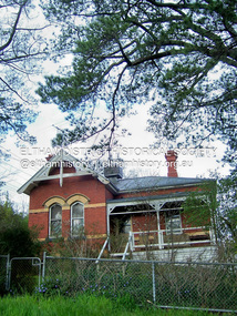
 Eltham District Historical Society Inc
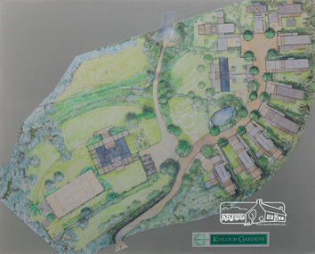
Drawing, Architectural Concept Plan: Kinloch Gardens proposed development, 93 Arthur Street, Eltham, 1997
Proposed design for Kinloch Gardens project with 12 sites illustrated plus Kinloch Main House. Ian Jelbart owned the entire Woodridge Estate but retained the top of the hill in Arthur Street until this development in 1997-1998, which he developed in conjunction with Graeme Gunn. Ian Jelbart inherited the land from his father who had purchased it cheap during the Great Depression. Kinloch is a castle in Scotland. Ink, wash and pencil on paper adhered to 13mm thick polyurethane boardKinloch Gardensarthur street, eltham, graeme gunn, ian jelbart, jelbart property, kinloch gardens -
 Eltham District Historical Society Inc
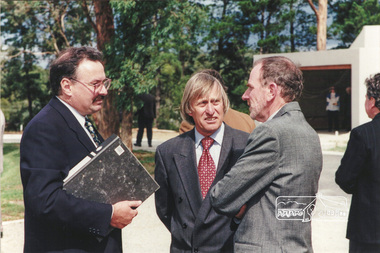
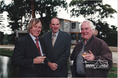
Photograph, Ian Jelbart (right) and Robert Marshall (centre) at the launch of the Kinloch Gardens development, 93 Arthur Street, Eltham, April 1998
Launch of the Kinloch Gardens development, 12 new double and triple storey homes along a private road in the gardens of Kinloch, a mansion set on 2.4ha in Arthur St. The launch was attended by Planning Minister Rob Maclellan and Nillumbik Shire president Robert Marshall, Architects Graeme Gunn and Ian Jelbart and approximately 100 guests.8 images; digital file only; created from scan undertaken by EDHS of a set of 26 colour 10 x 15 cm prints arthur street, eltham, graeme gunn, houses, ian jelbart, jelbart property, kinloch gardens, robert marshall, woodridge estate -
 Eltham District Historical Society Inc
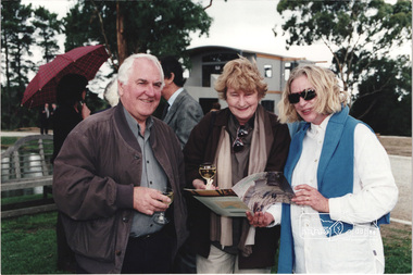
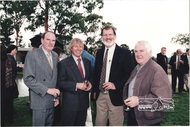
Photograph, Architect Graeme Gunn with unknown guests at the launch of the Kinloch Gardens development, 93 Arthur Street, Eltham, April 1998
Launch of the Kinloch Gardens development, 12 new double and triple storey homes along a private road in the gardens of Kinloch, a mansion set on 2.4ha in Arthur St. The launch was attended by Planning Minister Rob Maclellan and Nillumbik Shire president Robert Marshall, Architects Graeme Gunn and Ian Jelbart and approximately 100 guests.1 images; digital file only; created from scan undertaken by EDHS of a set of 26 colour 10 x 15 cm prints arthur street, eltham, graeme gunn, houses, ian jelbart, jelbart property, kinloch gardens, robert marshall, woodridge estate -
 Eltham District Historical Society Inc
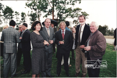
Photograph, Nillumbik Shire President Robert Marshall on left with Architects Ian Jelbart (centre) and Graeme Gunn at the launch of the Kinloch Gardens development, 93 Arthur Street, Eltham, April 1998
Launch of the Kinloch Gardens development, 12 new double and triple storey homes along a private road in the gardens of Kinloch, a mansion set on 2.4ha in Arthur St. The launch was attended by Planning Minister Rob Maclellan and Nillumbik Shire president Robert Marshall, Architects Graeme Gunn and Ian Jelbart and approximately 100 guests.4 images; digital file only; created from scan undertaken by EDHS of a set of 26 colour 10 x 15 cm prints arthur street, eltham, graeme gunn, houses, ian jelbart, jelbart property, kinloch gardens, robert marshall, woodridge estate -
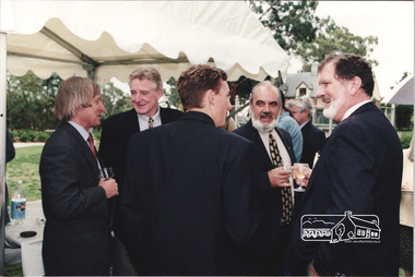
 Eltham District Historical Society Inc
Photograph, L-R: Architect Ian Jelbart, Nillumbik Shire President Robert Marshall, Nillumbik Cr. John Graves and Architect Graeme Gunn at the launch of the Kinloch Gardens development, 93 Arthur Street, Eltham, April 1998
Launch of the Kinloch Gardens development, 12 new double and triple storey homes along a private road in the gardens of Kinloch, a mansion set on 2.4ha in Arthur St. The launch was attended by Planning Minister Rob Maclellan and Nillumbik Shire president Robert Marshall, Architects Graeme Gunn and Ian Jelbart and approximately 100 guests.3 images; digital file only; created from scan undertaken by EDHS of a set of 26 colour 10 x 15 cm prints arthur street, eltham, graeme gunn, houses, ian jelbart, jelbart property, john graves, kinloch gardens, robert marshall, woodridge estate -
 Eltham District Historical Society Inc
Photograph, L-R: Christine and Ian Jelbart, Robert Marshall, John Graves and Graeme Gunn at the launch of the Kinloch Gardens development, 93 Arthur Street, Eltham, April 1998
Launch of the Kinloch Gardens development, 12 new double and triple storey homes along a private road in the gardens of Kinloch, a mansion set on 2.4ha in Arthur St. The launch was attended by Planning Minister Rob Maclellan and Nillumbik Shire president Robert Marshall, Architects Graeme Gunn and Ian Jelbart and approximately 100 guests.8 images; digital file only; created from scan undertaken by EDHS of a set of 26 colour 10 x 15 cm prints arthur street, christine jelbart, eltham, graeme gunn, houses, ian jelbart, jelbart property, john graves, kinloch gardens, robert marshall, woodridge estate -
 Eltham District Historical Society Inc
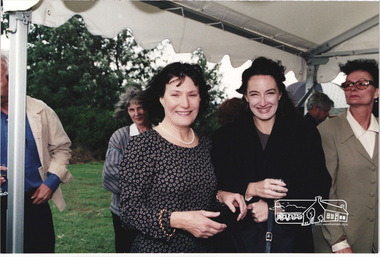
Photograph, Christine Jelbart (left) with two unknown women at the launch of the Kinloch Gardens development, 93 Arthur Street, Eltham, April 1998
Launch of the Kinloch Gardens development, 12 new double and triple storey homes along a private road in the gardens of Kinloch, a mansion set on 2.4ha in Arthur St. The launch was attended by Planning Minister Rob Maclellan and Nillumbik Shire president Robert Marshall, Architects Graeme Gunn and Ian Jelbart and approximately 100 guests.1 images; digital file only; created from scan undertaken by EDHS of a set of 26 colour 10 x 15 cm prints arthur street, christine jelbart, eltham, houses, jelbart property, kinloch gardens, woodridge estate -
 Eltham District Historical Society Inc
Photograph, Nillumbik Shire President Robert Marshall (left), Planning Minister Rob Maclellan (centre back to camera) and Cr. John Graves (right) at the launch of the Kinloch Gardens development, 93 Arthur Street, Eltham, April 1998
Launch of the Kinloch Gardens development, 12 new double and triple storey homes along a private road in the gardens of Kinloch, a mansion set on 2.4ha in Arthur St. The launch was attended by Planning Minister Rob Maclellan and Nillumbik Shire president Robert Marshall, Architects Graeme Gunn and Ian Jelbart and approximately 100 guests.1 images; digital file only; created from scan undertaken by EDHS of a set of 26 colour 10 x 15 cm prints arthur street, eltham, houses, jelbart property, john graves, kinloch gardens, rob maclellan, robert marshall, woodridge estate