Showing 919 items
matching rocks
-
 The Beechworth Burke Museum
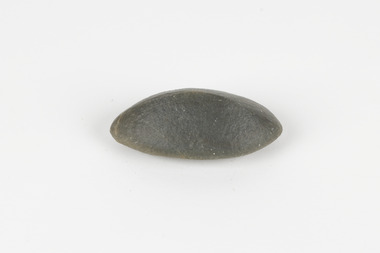
Geological specimen - Ventifact (wind- or ice-shaped) pebble
Ventifacts are sand-blasted rocks that are typically faceted and often display parallel grooves carved by wind-blown sand. They are useful indicators of wind direction and strength in environments such as deserts, mountains, and coastal areas because they are usually not hidden by later sediment, soil or vegetation cover. In Antarctica ventifaction is strongly related to the composition or type of rock. Ventifacts are important because they provide evidence for abraders such as sand, dust or snow and ice crystals, and offer a unique understanding of past wind processes that are effective in the reconstruction of past wind flow conditions and can provides clues to weather and climate changes in the past. Interestingly ventifacts have also been found on the surface of Mars. They were a threat to the NASA rover due to the sharp angles of the facets, created by the Martian wind over the course of millions of years. These Martian ventifacts act like weathervanes for past wind and weather patterns on the red planet in a similar manner to those found on earth.The Geological Survey of Victoria was instigated in response to the Victorian Gold Rush which began around 1851 in the Beechworth, Castlemaine, Daylesford, Bendigo and Ballarat areas. The survey was conducted by Alfred Richard Cecil Selwyn from his arrival in December 1852 until his resignation in 1869and during this time he trained many notable geologists, e.g. Aplin, Wilkinson, Daintree, who went on to other State survey senior positions. This specimen was among those donated to the Burke Museum in 1868.A hand-sized solid mineral specimen in shades of dark and light browns with light lines visible in all configurations and a groove on configuration 2.light lines visible in all configurations and a groove on configuration 2burke museum, beechworth, geological, geological specimen, ventifact, antarctic region, antarctic, alfred richard cecil selwyn, alfred selwyn, wind direction, wind strength, abraders, wind flow, climate change, reconstruction of wind flow conditions, weather change, mars -
 Bendigo Historical Society Inc.
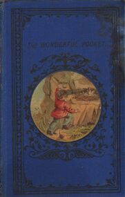
Book - HARRIS COLLECTION: BOOK AWARDED TO JONATHAN HARRIS, AXEDALE
Blue cover 160 page book 'The Wonderful Pocket', title barely discernible on front cover. Circular coloured painting of small child climbing upwards on rocks to reach bird nest, centred on front cover. Written on fly page, very faded, 'Presbyterian Sabbath School Axedale, Awarded to Jonathan Harris for attendance, October 1886 (? faint) Impress of bookseller ' Bookseller, R. Souter, Sandhurst' on top RH corner of flyleaf. Book is an instructive text 'an attempt to embody some useful truths in a form to interest the young' and contains a chapter at the end titled: 'wise sayings from Africa'. Author Chauncey Giles. Published by Wakefield, William Nicholson and Sons, London. S.D. Ewins and Co., and W. Tegg.Chauncey Gilesperson, individual, jonathan harris -
 The Beechworth Burke Museum
Geological specimen - Oil shale
This particular specimen is found in Wolgan Valley, New South Wales. It could be linked to the abandoned oil shale mining sites in Wolgan Valley such as Newnes. Newnes was an industrial complex operational in the early 20th century is now partly surrounded by Wollemi National Park. It produced motor spirit, kerosene, and gas oil. Newnes's Torbanite oil shale rock contained around 350 litres of oil shale per tonne. The Torbanite was mined by the Commonwealth Oil Corporation Ltd. Oil shale is a sedimentary rock and also a form of fossil fuel. It is often formed millions of years ago and usually contain fossilised remains of plants and/or animals. Oil shale is rich in kerogen that releases hydrocarbon when heated. These hydrocarbon can be used as an alternative petroleum or natural gas. The oil-shale rock was converted into oil by "destructive distillation"; the rock being heated until it broke down to form an oily vapour and an ash residue. Oil bearing shale is one of Australia's national assets. There are many oil companies established in Australia. It reflects Australia's rich natural resources as well as connection to the Australia's engineering and oil industry. The booming oil shale extraction businesses can be traced as far back as 1920s. This specimen is part of a larger collection of geological and mineral specimens collected from around Australia (and some parts of the world) and donated to the Burke Museum between 1868-1880. A large percentage of these specimens were collected in Victoria as part of the Geological Survey of Victoria that begun in 1852 (in response to the Gold Rush) to study and map the geology of Victoria. Collecting geological specimens was an important part of mapping and understanding the scientific makeup of the earth. Many of these specimens were sent to research and collecting organisations across Australia, including the Burke Museum, to educate and encourage further study.Piece of dark gray oil bearing shale with shades of light brown and fossilised leavesExisting label: OIL BEARING SHALE with / FOSSILISED LEAVES / Locality: Wongan Valley, NSW / Donor: Miss M. Cambell geological specimen, geology, geology collection, burke museum, beechworth, oil shale, shale, fossil fuels, alfred selwyn, wolgen valley, 1868 geological survey of victoria, rocks, sedimentary rocks, newnes, torbanite, commonwealth oil corporation ltd -
 Kiewa Valley Historical Society
Photograph - Folder of Photographs – Photocopied set of black and white photographs (pages 39 - 48) from the display folder put together by KVHS to document life on the Kiewa Valley Hydro-electric Scheme
Although the Kiewa Hydro-Electric Scheme was first proposed in 1911, construction did not commence until 1938. As part of the push to cut electricity costs and diversify supply, the Victorian Government (circa 1930) initiated the conversion from primarily brown coal supply to hydro – electricity. Field investigations during the 1940’s resulted in a new proposal for a scheme that had more than double the capacity of the 1938 scheme. The Kiewa Hydroelectric Scheme became the largest scheme of its kind in the State Of Victoria and the second largest scheme in Australia. The number of personnel involved in the planning and construction of the scheme increased dramatically. During the late 1940’s, most activity centered around the construction of the West Kiewa Power Station, Rocky Valley Reservoir, McKay Creek Power Station and the Bogong Creek Aqueduct.A common thread across all the larger hydro scheme constructions was the need for workers, both qualified and unqualified who came from around the world seeking a new life for themselves and their families. New accommodation and facilities were required for the army of workers engaged in construction in often remote and wild areas. The SEC had a high demand for timber, and set up the first of a number of sawmills at Bogong Creek in 1939 and set up the first hardwood logging in the headwaters of the Kiewa River. These new ‘towns’ such as Mt Beauty and Bogong, survived, serving the needs of operational personnel and their families, and expanding with growth of new industries. Mount Beauty, and to a lesser extent Bogong, are among these places. Large A3 size spiral bound display folder containing photocopied black and white photographs of various aspects of the early days of the Kiewa Valley Hydro-electric scheme including equipment, various work sites and photographs of workers and their families. 1-Breakdown in Circuit Breaker (Isolating Contacts) 2-Big Hill Bench- Site of No 5 Devlopment 3-No 1 Power Station 4-No 1 Pipeline, Anchor No 8 5-Push Dozing-RD8 Tractor 6- Tractor and driver at work 7- Workmen in unnamed tunnel 8- Front page of Journal of SECV Vol 15. Photograph of No 1 pipeline viewed from McKay Portal 9-Rocky Valley Dam Core Wall 10-Workmen working inside tunnel loading rocks into a rail truck. 1-Breakdown in (generator) Circuit Breaker (Isolating Contacts) Handwritten underneath (This is not a picture of any part of a generator. It is a circuit breaker Signed Ron White Ron was the Principal Hydro Engineer of the SEC Kiewa Scheme Page number 39 2-Big Hill Bench – Site of No. 5 Development (abandoned) Page number 40 3-No 1 Power Station Page number 41 4-No. 1 Pipeline, Anchor No. 8 Page number 42 5-Push Dozing – RD8 Tractor, 12 cubic yard Carryall and FD Cletrac Tractor Page number 43 6-No marking Page number 44 7-No marking Page number 45 8-Journal of State Electricity Commission of Victoria SEC Vol 15 No… April-May, 19… No 1 Pipeline-A view from McKay Portal G Hempenstall and D Sutton stiffening pipe section for transport during construction (….indicates missing text) Page Number 46 9-Rocky Valley Dam Core Wall Page number 47 10-No markings Page number 48 secv; kiewa hydro electric scheme; construction area; power stations; reservoirs; aqueduct; mt beauty; bogong -
 Flagstaff Hill Maritime Museum and Village
Painting - Oil painting, W. Langley-Taylor, Eagle Rock, Warrnambool, Vic, Late 19th to early 20th century
This painting is one of a pair of large paintings by W. Langley-Taylor in our collection. Currently, no further information has been found about the artist but research is ongoing. The subjects of these paintings are seascapes of notable areas of the coast on each side of Port Phillip Bay, south of Melbourne, Victoria. This painting is of Eagle Rock, Warrnambool, which is on the west of Port Phillip Bay. Eagle Rock is located about 400 metres west of Thunder Point, near Shelly Beach. The painting includes the rocky cliff formations looking east towards the Warrnambool Breakwater. The walk from the Thunder Point car park westwards to Shelly Beach has been popular over the decades with residents as well as tourists. Many photographs include the rock, with varying backgrounds depending on the angle of the camera. It is a popular dive site for locals and visitors, in calm weather! The site can be approached by boat from the open sea in favourable conditions, and there is plenty of native marine to be seen in this marine sanctuary. This part of Warrnambool’s rugged coastline is unprotected from the Southern Ocean with its wild icy winds and high seas. The painting’s crashing waves and the northerly direction of the smoke on the steamship sailing north show the effect of the southerly wind. INSCRIPTIONS “Mrs M Irby” and “980/Regency” The significance of the inscription “Mrs M Irby”, on the back of each of the two paintings, has not yet been discovered. Perhaps she was connected with the ship or shipping company “Irby”. A ship named “Irby”, built in Merseyside, Liverpool in 1881 by R & J Evans, Birkenhead. It was a four-masted iron ship built for the White Star Line. Henry Wilson Hewitt bought her in 1882, then later she was owned by Chadwick & Pritchard. In 1888 she was registered under the Irby Ship Co. Ltd. (trading as J. Joyce) in Liverpool. In 1912 Galgate Co. Ltd owned her. She traded between London, England and Australia, and is recorded as being in Melbourne and Hobart. In 1919 the Irby was destroyed by a mine when on her way to England. Or perhaps her name and the inscription in pencil “980/Regency” on the Eagle Rock Warrnambool, painting could be a delivery address for the paintings, perhaps an apartment in a hotel. This painting is significant geographically for its representation of the coastal scenery of Victoria, Australia. It is also significant as one of a pair of paintings of seascape, one at sites each side of Port Phillip Bay. The painting is significant historically as an example of late 19th and early 20th methods and materials used to construct a painting’s frame. Painting oil on board in a dark wooden frame, portrait orientation. Seascape of rock formation and cliffs, two yachts, a two-masted steamboat with red funnel and smoke, flying birds, high waves breaking onto rocks, blue sky with clouds, some tinted pink.. The title is painted on lower left corner and the artist, W. Langley-Taylor, has signed his name on lower right. The inscription on the back is a handwritten script in red crayon or thick red pencil. The board is held in place inside the timber frame with small, dark metal tacks around all sides. Metal eyes join the wire to the frame. Small round, dark metal nail heads are dispersed around the frame and there is a change of colour on both the board and the wood of the frame. Painted on front “W.LANGLEY-TAYLOR.” and “EAGLE ROCK, WARRNAMBOOL, VIC.” Handwritten on back “Mrs. M. Irby” and “980 [underlined] Regency”flagstaff hill, warrnambool, shipwrecked coast, flagstaff hill maritime museum, maritime museum, shipwreck coast, flagstaff hill maritime village, great ocean road, eagle rock warrnambool, w. langley-taylor, oil painting, wall decoration, seascape of victoria's coast, mrs m irby, art, seascape, pair of paintings -
 Federation University Historical Collection
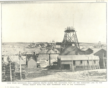
Book, J.W. Gregory, Memoirs of the Geological Survey of Victoria No. 4: The Ballarat East Gold-Field, 1907, 1907
Blue soft covered report with 40 plates and plans. Inciudes Geology of Ballarat. Little Bendigo Goldfield, Ballarat West Goldfield, Ballarat East Goldfield, history, nuggets, indicators, faults, microscopic structure of Ballarat Rocks and ores, general type of the Ballarat East Mines and the genesis of their ores. Mines include New Zealand Trust, Llanberris No. 1, Llanberris No 2, Victoria United, Britannia United, New Britannia, Last Chance, Exchange, Normanby North, New Normanby, North Woah Hawp. Photpgraphic plates include: Victoria United Mine, Llanberres No. 1, Normanby North, North Woah Hawp Mine, View looking south from the Britannia Mullock Heap, View from Sovereign Hill, The place in Learmonth Street Golden Point where gold was first discovered at Ballarat. j.w. gregory, ballarat east, ballarat east goldfield, e.j. dunn, geolological survey of victoria, new zealand trust, llanberris no. 1, llanberris no 2, victoria united, britannia united, new britannia, last chance, exchange, normanby north, new normanby, north woah hawp, mining, indicators, gold mining, poppet head -
 Phillip Island and District Historical Society Inc.
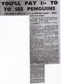
Memorabilia, Phillip Island Memorabilia
Items used in Research for Book - "Penguin Land" by Gregor BuchananHistorical1162-01 Article from the Wonthaggi Express - Penguin Parade Admission 1162-02 Brochure called "The Short Way to Cowes" detailing taking the train from Flinders Street Railway Station, Melbourne to Stony Point then by Ferry to Cowes 1162-03 Pg 1 & 2 - Souvenir Programme "Music for the People" to be held weather permitting on the Cowes Foreshore at 2pm February 20th, 1955 1162-04 - Card - Drawing of a Fur Seal - one of the 5000-odd Seals on Seal Rocks, as seen from The Nobbies Road House, Phillip Island 1162-05 Pg 1 & 2 - Cowes - Dandenong Road Service showing Daily Road Route and connection from Dandenong to Flinders St. Melbourne. Time Table to and from Cowes to Dandenong"penguin land" book, gregor buchanan, seals, ferry, stony point to cowes, cowes to dandenong, penguin parade, variety concert ticket, tourism -
 Eltham District Historical Society Inc
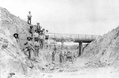
Negative - Photograph, Construction of Railway Line, Greensborough to Eltham, 1901
The Silver Street Bridge, 1901 Butty Gang workers excavate a rock cutting near the Silver Street bridge prior to laying of track. The Butty Gang system versus the Contract System was subject to public debate regarding cost benefits at the time of the Eltham line construction. Butty gang workers were a group of men who take a contract for a part of a work, as in the construction of railroads, etc., the proceeds being equally divided between them, with something extra to the foreman. Some hold picks, a couple of horses and carts are lined up probably for carting the broken rock away, dirt, rocks and shale lay at the bottom. A pair of small wooden buckets are evident, most likley to provide drinking water. The timber Silver Street bridge crosses the cutting in the background. The opening of the railway line from Heidelberg to Eltham took place on the 6th June 1902. Similiar to 810. Source: Mrs. Dandy, Montmorency and Miss McColl, 8 Anderson St., HeidelbergThis photo forms part of a collection of photographs gathered by the Shire of Eltham for their centenary project book,"Pioneers and Painters: 100 years of the Shire of Eltham" by Alan Marshall (1971). The collection of over 500 images is held in partnership between Eltham District Historical Society and Yarra Plenty Regional Library (Eltham Library) and is now formally known as the 'The Shire of Eltham Pioneers Photograph Collection.' It is significant in being the first community sourced collection representing the places and people of the Shire's first one hundred years.Digital image 120 format B&W negativeshire of eltham pioneers photograph collection, eltham, railway workers, 1901, butty gang, overpass, railway construction, railway line construction, silver street bridge -
 National Wool Museum
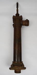
Tool - Water Pump, c.1960
A windmill may be considered one of the most iconic sights of Australian Farming life. A pump like this rest at the heart of all such windmills, turning wind energy into water for farmers both here in Australia and worldwide alike. The water windmills access is referred to as an aquifer, an underground layer of water trapped in rocks but accessible with use of water wells and windmills. Australia is home to an underground aquifer known as the Great Artesian Basin. It is the largest and deepest aquifer in the world. Stretching over 1,700,000 square kilometres, the Basin underlies nearly a quarter of the continent including most of Queensland, the south- east corner of the Northern Territory, the north-east part of South Australia and the northern part of New South Wales. The basin is 3,000 metres deep in places and is estimated to contain 64,900 cubic kilometres of groundwater. To try and give this number context, a megalitre is a million litres. The Great Artesian Basin contains 65,000 million megalitres of water. This would be enough to cover all the land on the planet in almost half a metre of water.Lift style piston pump typical of an Australian farm connected to a multi-bladed windmill. Bronze cylindrical construction coming up from removable wood base. Rotating lever is above outlet pipe which would send water to the storage tank.windmill, australian farming, great artesian basin, aquifer -
 Queenscliffe Maritime Museum
Functional object - Bottle
Recovered from the wreck site of the Fiji. The barque Fiji left Hamburg on 22nd of May 1891. The vessel went ashore at 3 am on the morning of the 6th of September 1891in squally and boisterous weather soon after sighting Cape Otway. The wind had suddenly veered, and the vessel missed stays after attempting to wear ship and was driven onto the rocks. Attempts were made to launch the boats but they were swamped and dashed to pieces. Delays in getting the lifeboat and rocket apparatus to the scene resulted in 12 of the 25 crew drowning after 10 hours trapped on board. A local resident, Arthur Wilkinson, lost his life trying to save one of the crew who was struggling in the surf. Coffins were made out of the wreck timbers and the men buried on the cliff top above the wreck. The deaths precipitated critical comment in the press over the lack of prompt action. Other news items appeared claiming drunk and disorderly behaviour by plunderers amongst the corpses and wreckage on the beach. The controversy reached parliament.Brown bottleWarner's, Safe, Cure, Melbourne Aust, London Eng, Toronto Can, Rochester NY USAwrecks, salvage, bottle, barque fiji -
 Stawell Historical Society Inc
Photograph, Fluming Water Supply in the Grampians 1991 -- 9 Photos -- Coloured
Coloured photos of Fluming Water Supply in the Grampians. a. Grampians Exit of tunnel through Mt William Range built 1874. b. Halls Gap Fyan's Creek with buried pipe from new diversion Weir Nov 24/91 (Fume Main). c. Halls Gap New Diversion Weir (Keith Phillips) Nov 24/1991. d. Halls Gap Old pipe to open flume adapter Nov 24/1991. e. Halls Gap Old metal open flume Nov24/91. f. Halls Gap Old metal flume and man made stone supporting wall. g. Halls Gap Overhanging rocks above old fume line Nov 24/1991. h. Halls Gap Old pipe to open flume adapter Bill Holmes Nov 24/91. i. Grampians Old hut for controlling flow valves etc. at Stawell side of Mount William Range after tunnel exit. Nine colour photographs of various views around a tunnel through a hill site.grampians water supply flume -
![Waterfall Scene on the Coliban River, near Elphinstone / [by] Nicholas Caire, circa 1876](/media/collectors/550653872162f11fb04854aa/items/577b4d42d0cdd10948c96acf/item-media/577b4dbfd0cdd10948c9b34f/item-fit-380x285.jpg) Kew Historical Society Inc
Kew Historical Society IncPhotograph, Anglo-Australasian Photographic Company, Waterfall Scene on the Coliban River, near Elphinstone, c. 1876
Nicholas Caire was born on Guernsey in the Channel Islands in 1837. He arrived in Adelaide with his parents in about 1860. In 1867, following photographic journeys in Gippsland, he opened a studio in Adelaide. From 1870 to 1876 he lived and worked in Talbot in Central Victoria. In 1876 he purchased T. F. Chuck's studios in the Royal Arcade Melbourne. In 1885, following the introduction of dry plate photography, he began a series of landscape series, which were commercially successful. As a photographer, he travelled extensively through Victoria, photographing places few of his contemporaries had previously seen. He died in 1918. Reference: Jack Cato, 'Caire, Nicholas John (1837–1918)', Australian Dictionary of Biography.An original, rare photograph from the series 'Views of Victoria: General Series' by the photographer, Nicholas Caire (1837-1918). The series of 60 photographs that comprise the series was issued c. 1876 and reinforced a neo-Romantic view of the Australian landscape to which a growing nationalist movement would respond. Nicholas Caire was active as a photographer in Australia from 1858 until his death in 1918. His vision of the Australian bush and pioneer life had a counterpart in the works of Henry Lawson and other nationalist poets, authors and painters.Views of Victoria (General Series) No.23 / ‘Waterfall scene on the Coliban River, near Elphinstone’ / Albumen silver photograph mounted on boardOn reverse: ‘The scene this illustration presents is but one of the many that exist along the course of this shallow River, which, like its parent the Campaspe, abounds with rocky and romantic scenery. The fall of the River at this place is over one hundred feet, but is broken by a long course of rocks to the lower bed; the actual fall as seen is about forty feet. The Coliban, though only a branch of the Campaspe, derives its name from the fact that its course runs through the Coliban Park. Gold is found in considerable quantities along the banks and in the stream, but at the present time these diggings are worked only by Chinamen.’nicholas caire (1837-1918), australia - landscape photography -
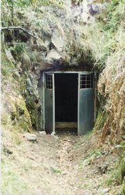
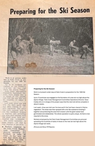 Falls Creek Historical Society
Article - Newspaper article "Last Hoot" development - Summer of 1984/85
Over the summer of 1984/85 extensive regeneration work was carried out to establish the “Last Hoot”. It was a big job and took all summer to complete the work which included throwing rocks of the run, digging in cross drains and spreading the area with hay. All work was done manually. Though difficult physical work, those who dedicated their time and labour to the task have interesting memories of that time, including arriving to load up hay bales only to find the cattle from the high plains had walked across the dam wall to come and enjoy a fabulous feast! The Hoot Ski Trail has two sections. Fast Hoot is a 341 metre blue downhill run located near Falls Creek. The Last Hoot is a one km blue ski run (piste) trail which can be used in both directions. It finishes at Slalom Plaza in Falls Creek Village. Snowlands Lodge is near the bottom of the trail in Slalom Street. One of its most popular features is “The Last Hoot” Restaurant.This article is significant because it documents the work carried out to establish a popular ski trail at Falls Creek, VictoriaThis newspaper article reports on the work carried out to prepare for a new ski trail the "Last Hoot" at Falls Creek over the summer of 1984/85.In image L to R Debbie Howie, Larraine Boulton, Nina Frueauf, Rob McEwan, Eric Napierthe last hoot, deb howie -
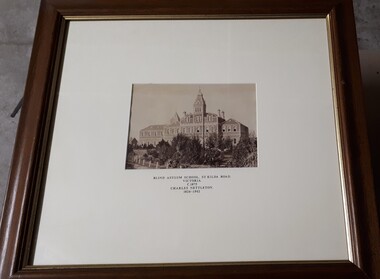 Vision Australia
Photograph - Image, Charles Nettleton, Blind Asylum School, St Kilda Road, circa 1875
Unsubstantiated photograph of the Asylum for the Blind in 1875. The four storey bluestone building rises above a group of trees planted in the garden. A picket and wire/string fence border the unpaved circular driveway. 2 black and white images of the Guiding Light at Elanora Blind Asylum School, St Kilda Road Victoria c. 1875 Charles Nettleton 1826-1902 Spencer Scott Sandilands 546 High Street, East Preson, 3181 Melbourne, Victoria, Australia, Tel: (03) 529 8011 Fax: (03) 521 1754 33 George Street, The Rocks, 2000 Sydney, New South Wales, Australia, Tel: (02) 241 4251 Fax: (02) 2414535 Rare Prints, Antiquarian Books, Old Maps, Australiana, Antiques, Photographs, Framing c.1875 Charles Nettleton School from the Blind Original Photograph $65 Guaranteed over 100 years oldroyal victorian institute for the blind, buildings -
 The Beechworth Burke Museum
Photograph
This photograph depicts four men standing near a large unidentified building. This building is the entrance to a deep lead mine shaft. There is a bridge entering the building, which was used to access the elevator to the shaft. Deep lead mining involved placing large shafts into the ground which miners use to access deeper locations in order to excavate the rocks in the search for lead. Deep lead mining was highly dangerous as roofs could cave in of the soil was loose. Therefore, this particular mining considered to be highly undesirable profession as many miners did not want to work long hours nor risk their lives in the search for lead. Indigo Shire was a large area where deep lead mining took place, and thus the landscape and environment was largely impacted by these mining businesses. The Indigo Shire grew in population and wealth in the early 1850s when people came into this location in the hopes of finding gold and making a fortune. Ultimately, the accessibility and availability of gold and precious metals decreased once the gold reserves dried up and alongside this, the large population moved away. The Ovens was also heavily impacted environmentally as deep mining resulted in the change in land formation.The search for gold is ingrained into the history of Victoria and therefore, images like this one which portray an open cut sluicing site can reveal important information for society and technology for the date when the photograph was taken. This image is of important historical significance for its ability to convey information about the methods used to find gold in Indigo Shire. It also shows a location where deep mining was undertook which provides insight into the impact of deep mining on the environment at a time when it was done. This image is important for current research into the history of Indigo Shire, a region in Victoria's north-east. Therefore, this image has the capacity to be beneficial for research into society and the motivations of those living and working in this region during this period and therefore, has social significance. The Beechworth Burke Museum has additional images relating to deep lead mining and Indigo Shire which can be analysed and studied alongside images like this one.Sepia coloured retangular photo printed on gloss photographic paper.Reverse: 1997, 2510/ A02570/ Deep Lead Mining/ page 94/ 65%/ Burke Museum, Photo 44beechworth, burke museum, indigo shire, deep lead mining, mining, gold, gold mining -
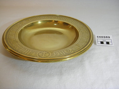 Christ Church Anglican Parish of Warrnambool
Plate, Untitled, Brass Alms dish, C.1902
Brass Collection Plate presented to St Paul's Anglican Church, Allansford, by the mother of Joseph & Frank Dallimore as a Memorial to the two brothers who drowned at Ryan's Den (near Cape Otway) on Jan 1st 1903. Major Joseph Dallimore (aged 32) was on leave from Sth Africa during the war and he, his wife (Beatrice Wiggs) and baby, his brother Frank Rupert Dallimore (aged 22), a farm hand Arthur Geach (aged 19) and a house maid servant, were picnicing at Ryan's Den (near Cape Otway) when the three men went walking, but never returned, all assumed drowned. One theary has it - Mrs M.E. Dallimore was picnicing at Lake Gillear beach when an enormous wave swept over the shore - (much larger than any other during that day) and rolled in all along the beach. This wave may have also reached the area where the three men were walking on the rocks and swept them into the ocean. Only one body was recovered - some 4 weeks later - that of Frank Rupert Dallimore and washed into Brown's Creek, 1 mile from the Johanna River and ten miles east of Ryans Den.It is a memorial plate and records the family's attachment and importance to the Church.Brass engraved and embossed Memorial Collection PlateEmbossed wording around edge of plate in Old English font reads - "All things come of Thee and of Thine own have we given Thee". The inscription on the tondo of the plate reads - "TO THE GLORY OF GOD / AND IN MEMORY OF / JOSEPH & FRANK RUPERT DALLIMORE, / WHO WERE DROWNED AT RYAN'S DEN, / JAN 1ST 1903. / PRESENTED BY THEIR LOVING MOTHER, / M.E.DALLIMORE."brass st pauls anglican church allansford warrnambool church of england christ church parish of warrnambool collection plate memorial plate dallimore drowning ryan s den alms dish -
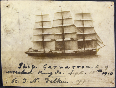 Mission to Seafarers Victoria
Photograph, George Schutze, Ship Carnarvon Bay wrecked King Island 15 September 1910 - R.J.N Filkin apprentice, c. 1910
The ship Carnarvon Bay bound from Liverpool to Sydney with a general cargo struck rocks off Stokes Point on the coast of King Island on Thursday 15 September 1910. On the day the crew used two lifeboats but were separated. One of them with Captain W. Griffith and 17 men was rescued by the SS Taracoola and brought back to Melbourne. Apprentice, R.J.N Filkin was amongst them (his name is listed on the Argus article relating the event (Monday 19 September 1910). In the article called "Welcome Shelter" it seems it was the first sea voyage for the young Filkin. The other boat with 15 men was lost for several hours. There was no casualties but the 3000 ton cargo was lost. The seamen were received at the Sailors Home then welcomed at the Mission by Reverend Haire as shown on a photograph publish in the Punch (22 September 1910). Reverend Gurney Goldsmith was in England at the time. The crew was invited to an evening of entertainment organised by artist Violet Teague at the Masonic Hall on the 19th of September. According to the article "Welcome Shelter" she was painting the "tableaux" at the Mission when the seamen were present, interviewed by the journalist. This evening organised by the Ladies Harbour Lights Guild was planned to raise funds for the Mission.Sepia photograph depicting the ship Carnarvon Bay at sea with a written inscription in black ink.Ship Carnarvon Bay wrecked King Island 15 September 1910 - R.J.N Filkin apprenticeshipwreck, apprentice, king island, carnarvon bay, captain griffith, violet teague, masonic hall, ss taracoola, crews and ships -
 Warrnambool and District Historical Society Inc.
Souvenir - Shipwreck item, Falls of Halladale, 1886
The Falls of Halladale was a four-masted iron-hulled barque built for the long-distance bulk carrier trade. In dense fog on the night of 14 November 1908 she was sailed onto rocks off Peterborough due to a navigational error. The 29 crew abandoned ship safely and reached shore by boat. The ship was left foundering with sails unfurled. For weeks afterwards large crowds gathered to view the ship as she gradually broke up and sank in the shallow water. Shortly after the accident the ship's master, Captain Thomson, faced a Court of Marine Enquiry in Melbourne. He was found guilty of a gross act of misconduct, having carelessly navigated the ship, neglected to take proper soundings and failing to place the ship on a port tack before it became too late to avoid shipwreck. Thomson's punishment included a small fine and six months suspension of his Master's Certificate of Competency. The hull lies on its starboard side about 300 metres off-shore in 3-15 metres of water. The original cargo included 56,763 roofing slates and coils of barbed wire. 22,000 slates were salvaged in the 1980s and used as roofing at Flagstaff Hill Maritime Village, Warrnambool.This item has historical significance as it came from one of the known shipwrecks along the South West coast of Victoria. There are a number of photographs of the wreck as it founded on the rock and hence is an image with which many people are familiar. Curved piece of timber with flat base from the wreck of the ship Falls of Halladale. Inside is recessed with slight ledge near back. A chunk of timber is missing on the top. The face has swirled carvings with leaf and seed design and base curved to the edge.Hand painted in red paint on inside bottom edge 'PETERBOROUGH'. Hand painted in white paint on bottom 'FALLS OF HALLADALE/WRECKED/PETERBOROUGH/VIC/NOV. 1908'melbourne, shipwrecks, flagstaff hill maritime village, warrnambool, falls of halladale, barques, peterborough victoria, roofing slates, captain thomson, thomson, court of marine enquiry -
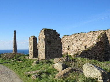
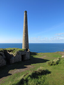
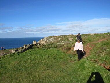
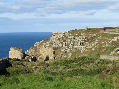
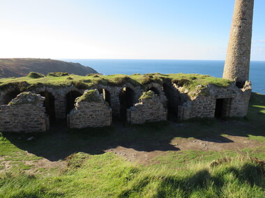
 Ballarat Heritage Services
Photograph - Colour, Dorothy Wickham, St Just, Cronwall, World Heritage Site
A stone’s throw from Land’s End, this is the most westerly Area of the Site. St Just is characterised by big skies, jagged rocks, stark moorland, and iconic clifftop engine houses perched above the Atlantic in some incredible locations. No wonder this dramatic setting has inspired generations of artists, writers and photographers. World-famous for their mineralogy, the mining sites here are extremely well preserved – as is the sense of community amongst the people whose lives they once dominated. This Area’s unique geography and mineralogy meant that undersea mining was more concentrated here than anywhere else in the world in the 18th and 19th centuries. The oldest surviving Cornish beam engine (constructed in 1840) remains in its original engine house at Levant, restored and still working under steam. Geevor, one of the last mines to close in Cornwall (1990), was saved from demolition and is now the largest metalliferous mine site open to the public in the UK. The historic mining town of St Just is home to characteristic rows of granite mine workers’ cottages, public squares, shops, cafés, art galleries and, just off Bank Square, a medieval grassed amphitheatre – the Plen an Gwary or ‘playing place’.st just, world heritage, ellis, penrose, cornwall, mining, mines -
 Ballarat Heritage Services
Photograph - Colour, Dorothy Wickham, St Just, Cornwall, World Heritage Site
A stone’s throw from Land’s End, this is the most westerly Area of the Site. St Just is characterised by big skies, jagged rocks, stark moorland, and iconic clifftop engine houses perched above the Atlantic in some incredible locations. No wonder this dramatic setting has inspired generations of artists, writers and photographers. World-famous for their mineralogy, the mining sites here are extremely well preserved – as is the sense of community amongst the people whose lives they once dominated. This Area’s unique geography and mineralogy meant that undersea mining was more concentrated here than anywhere else in the world in the 18th and 19th centuries. The oldest surviving Cornish beam engine (constructed in 1840) remains in its original engine house at Levant, restored and still working under steam. Geevor, one of the last mines to close in Cornwall (1990), was saved from demolition and is now the largest metalliferous mine site open to the public in the UK. The historic mining town of St Just is home to characteristic rows of granite mine workers’ cottages, public squares, shops, cafés, art galleries and, just off Bank Square, a medieval grassed amphitheatre – the Plen an Gwary or ‘playing place’.st just, world heritage,, ellis,, penrose, cornwall, mining, mines -
 Ballarat Heritage Services
Photograph - Colour, Dorothy Wickham, St Just, Cornwall, World Heritage Site
A stone’s throw from Land’s End, this is the most westerly Area of the Site. St Just is characterised by big skies, jagged rocks, stark moorland, and iconic clifftop engine houses perched above the Atlantic in some incredible locations. No wonder this dramatic setting has inspired generations of artists, writers and photographers. World-famous for their mineralogy, the mining sites here are extremely well preserved – as is the sense of community amongst the people whose lives they once dominated. This Area’s unique geography and mineralogy meant that undersea mining was more concentrated here than anywhere else in the world in the 18th and 19th centuries. The oldest surviving Cornish beam engine (constructed in 1840) remains in its original engine house at Levant, restored and still working under steam. Geevor, one of the last mines to close in Cornwall (1990), was saved from demolition and is now the largest metalliferous mine site open to the public in the UK. The historic mining town of St Just is home to characteristic rows of granite mine workers’ cottages, public squares, shops, cafés, art galleries and, just off Bank Square, a medieval grassed amphitheatre – the Plen an Gwary or ‘playing place’.st just, world heritage, ellis, penrose, cornwall, mining, mines -
 Ballarat Heritage Services
Photograph - Colour, Dorothy Wickham, St Just, Cronwall, World Heritage Site
A stone’s throw from Land’s End, this is the most westerly Area of the Site. St Just is characterised by big skies, jagged rocks, stark moorland, and iconic clifftop engine houses perched above the Atlantic in some incredible locations. No wonder this dramatic setting has inspired generations of artists, writers and photographers. World-famous for their mineralogy, the mining sites here are extremely well preserved – as is the sense of community amongst the people whose lives they once dominated. This Area’s unique geography and mineralogy meant that undersea mining was more concentrated here than anywhere else in the world in the 18th and 19th centuries. The oldest surviving Cornish beam engine (constructed in 1840) remains in its original engine house at Levant, restored and still working under steam. Geevor, one of the last mines to close in Cornwall (1990), was saved from demolition and is now the largest metalliferous mine site open to the public in the UK. The historic mining town of St Just is home to characteristic rows of granite mine workers’ cottages, public squares, shops, cafés, art galleries and, just off Bank Square, a medieval grassed amphitheatre – the Plen an Gwary or ‘playing place’.st just, world heritage, ellis, penrose, cornwall, mining, mines -
 Ballarat Heritage Services
Photograph - Colour, Dorothy Wickham, St Just, Cornwall, World Heritage Site
A stone’s throw from Land’s End, this is the most westerly Area of the Site. St Just is characterised by big skies, jagged rocks, stark moorland, and iconic clifftop engine houses perched above the Atlantic in some incredible locations. No wonder this dramatic setting has inspired generations of artists, writers and photographers. World-famous for their mineralogy, the mining sites here are extremely well preserved – as is the sense of community amongst the people whose lives they once dominated. This Area’s unique geography and mineralogy meant that undersea mining was more concentrated here than anywhere else in the world in the 18th and 19th centuries. The oldest surviving Cornish beam engine (constructed in 1840) remains in its original engine house at Levant, restored and still working under steam. Geevor, one of the last mines to close in Cornwall (1990), was saved from demolition and is now the largest metalliferous mine site open to the public in the UK. The historic mining town of St Just is home to characteristic rows of granite mine workers’ cottages, public squares, shops, cafés, art galleries and, just off Bank Square, a medieval grassed amphitheatre – the Plen an Gwary or ‘playing place’.st just, world heritage, ellis, penrose, cornwall, mining, mines -
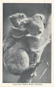 Phillip Island and District Historical Society Inc.
Souvenir Photographs, Valentine Publishing Co. Pty. Ltd, 1940's
Souvenir Photographic Strip photo envelope donated by Anne LucasBlack & White photographs in a Souvenir Folder. Photos of wildlife and coastal scenes at Phillip Island.On Cover: "Cowes, Phillip Island. Photographic Souvenir" 230-01. "Australian Native Bears (Koalas)." 230-02. "Bathing scene at Cowes." 230-03. "The Pier, showing Isle of Wight Hotel." 230-04. "The Beach at Cowes." 230-05. "Seals on Seal Rock." 230-06. "The Beach, Cowes." 230-07. "War Memorial and Pier". 230-08. "The Pier. Cowes (Phillip Island)" 230-09. "Rocks at Cape Woolamai. Cowes (Phillip Island)." 230-10. "The Nobbies." 230-11. "Sea Birds at Phillip Island." 230-12. "Rocky Headland, Cape Woolamai." 230-13. "Australian Native Bears (Koalas)." 230-14. "Forrest Caves."wildlife - koalas, wildlife - sea birds, coastline cape woolamai, the nobbies phillip island, seals on seal rocks phillip island, wildlife - seals, cowes pier phillip island, cowes jetty, cowes beach phillip island, forrest caves, phillip island, seal rocks phillip island, cowes war memorial, war memorial cowes phillip island, cenotaph cowes phillip island, anne lucas -
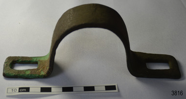 Flagstaff Hill Maritime Museum and Village
Functional object - Bracket
This metal bracket is part of the wooden barque, the Grange, built in 1840. The bracket was recovered from the shipwreck of the Grange in around 1968, 110 years after the Grange was wrecked (see below for further details on the Grange). It is part of the John Chance Collection. THE GRANGE, 1840-1858- The wooden barque ’Grange’ was a three-masted ship built in Scotland in 1840 for international and coastal trade. On March 22, 1858, the Grange set sail from Melbourne under Captain A. Alexander, carrying a cargo of ballast. The barque had left the Heads of Phillip Bay and was heading west along the Victorian coast towards Cape Otway. The ship struck Little Haley’s Reef at Apollo Bay due to a navigational error and was stuck on the rocks. The crew left the ship carrying whatever they could onto the beach. Eventually, the remains of the hull, sails and fittings were salvaged before the wreck of the Grange broke up about a month later. About 110 years later, in 1968, the wreck of the Grange was found by divers from the Underwater Explorers Club of Victoria. They were amazed to find a unique, six to nine pound carronade (type of small cannon) and a cannonball on the site. There have been no other similar carronades recorded. In that same year the anchor of the Grange was recovered by diver John Chance and Mal Brown. The bracket is significant historically as an example of hardware used when building wooden ships in the early to mid-19th century. The bracket is historically significant as an example of the work and trade of blacksmith. The bracket also has significant as it was recovered by John Chance, a diver from the wreck of the Grange in the 1968. Items that come from several wrecks along Victoria's coast have since been donated to the Flagstaff Hill Maritime Village’s museum collection by his family, illustrating this item’s level of historical value. The bracket is historically significant for its association with the 1840s wooden barque, the Grange. The Grange is an historical example of a Scottish built vessel used for international and coastal trader of both cargo and passengers in the mid-19th century. The Grange is an example of an early ship, designed with a wooden hull. It is significant as a ship still available to divers along the south coast of Victoria, for research and education purposes. The Grange is an example of a mid-19th century vessel that carried a weapon of defence onboard.Bracket, brass, U shaped with rectangular flat ends. Both ends have a formed rectangular hole in them; the hole has rounded corners. The metal has corroded in places and has green concretion.flagstaff hill, warrnambool, flagstaff hill maritime museum, maritime museum, shipwreck coast, flagstaff hill maritime village, great ocean road, west coast trader, apollo bay, mid-19th century shipwreck, the grange, scottish barque, little henty reef, captain a alexander, underwater explorers club of victoria, 1840s carronade, vhr 5297, coastal trader, wooden shipwreck, john chance, wooden ship, ship fitting, bracket -
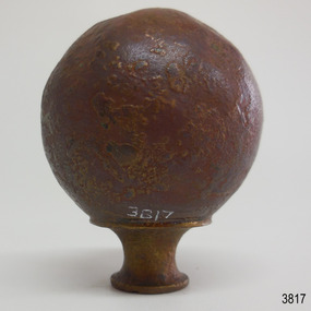 Flagstaff Hill Maritime Museum and Village
Decorative object - Sphere
This metal sphere is part of the wooden barque, the Grange, built in 1840. The sphere was recovered from the shipwreck of the Grange in around 1968, 110 years after the Grange was wrecked (see below for further details on the Grange). It is part of the John Chance Collection. THE GRANGE, 1840-1858- The wooden barque ’Grange’ was a three-masted ship built in Scotland in 1840 for international and coastal trade. On March 22, 1858, the Grange set sail from Melbourne under Captain A. Alexander, carrying a cargo of ballast. The barque had left the Heads of Phillip Bay and was heading west along the Victorian coast towards Cape Otway. The ship struck Little Haley’s Reef at Apollo Bay due to a navigational error and was stuck on the rocks. The crew left the ship carrying whatever they could onto the beach. Eventually, the remains of the hull, sails and fittings were salvaged before the wreck of the Grange broke up about a month later. About 110 years later, in 1968, the wreck of the Grange was found by divers from the Underwater Explorers Club of Victoria. They were amazed to find a unique, six to nine pound carronade (type of small cannon) and a cannonball on the site. There have been no other similar carronades recorded. In that same year the anchor of the Grange was recovered by diver John Chance and Mal Brown. The sphere is significant historically as an example of hardware used when building wooden ships in the early to mid-19th century. The sphere is historically significant as an example of the work and trade of blacksmith. The sphere also has significant as it was recovered by John Chance, a diver from the wreck of the Grange in the 1968. Items that come from several wrecks along Victoria's coast have since been donated to the Flagstaff Hill Maritime Village’s museum collection by his family, illustrating this item’s level of historical value. The sphere is historically significant for its association with the 1840s wooden barque, the Grange. The Grange is an historical example of a Scottish built vessel used for international and coastal trader of both cargo and passengers in the mid-19th century. The Grange is an example of an early ship, designed with a wooden hull. It is significant as a ship still available to divers along the south coast of Victoria, for research and education purposes. The Grange is an example of a mid-19th century vessel that carried a weapon of defence onboard. Sphere; thin hollow copper, various shades of brown, dimpled or hammered surface with a sheen, no joins. Base has a small hole and is fitted with a hollow, cylindrical brass collar. The collar had a rim on top, inward curving sides and a narrower rim on the bottom. The sphere looks similar to a bed post knob.flagstaff hill, warrnambool, flagstaff hill maritime museum, maritime museum, shipwreck coast, flagstaff hill maritime village, great ocean road, west coast trader, apollo bay, mid-19th century shipwreck, the grange, scottish barque, little henty reef, captain a alexander, underwater explorers club of victoria, 1840s carronade, vhr 5297, coastal trader, wooden shipwreck, john chance, wooden ship, ship fitting, sphere, knob, bed knob, post decoration -
 Phillip Island and District Historical Society Inc.
Photographs, Kodak, c 1948
A collection of photographs donated by Rhonda McInnes (nee Closs) from her father, Don Closs 's collection. Taken whilst her parents were courting and had a trip to Phillip Island.327-01 - Black & White photograph of Westernport with Cowes Ferry and other ships in the background. 327-02 - Black & White photograph of Cowes Pier looking towards Cowes. 327-03 - Black & White photograph of the Hollydene Guest House with people standing at the front gate. 327-04 - Black & White photograph of the Cowes Vehicular Ferry arriving/departing from the Cowes Pier. 327-05 - Black & White photograph of the Proprietor of the Hollydene Guest House with Janet ? 327-06 - Black & White photograph of The Nobbies, Phillip Island. 327-07 - Black & White photograph of The Nobbies with Seal Rocks in the distance. 327-08 - Black & White photograph of The Nobbies with Janet ? in the foreground. 327-09 - Black & White photograph of Churchill Island from Phillip Island. 327-10 - Black & White photograph of the Phillip Island Suspension Bridge taken from San Remo. 327-11 - Black & White photograph of Bert West and his bus with two passengers getting onto the bus. the nobbies, cowes pier phillip island, westernport, cowes car ferry, hollydene guesthouse cowes phillip island, churchill island, phillip island suspension bridge, bert west -
 The Beechworth Burke Museum
Photograph, Unknown
The A1 Gold Mine is located north of Woods Point, near Jamieson, in the Upper Goulburn region of Victoria. Gold was discovered at the A1 site in 1861 and mining operations began in 1864. The A1 Mine Settlement refers to a small township known variously as Castle Reef, Castle Point, and Raspberry Creek, which developed in the 1860s around mining industry centred on a crushing machine that worked the three gold reefs in the area. Historically, the name "A1"referred to the high quality of gold found in the quartz reefs at depths of at least two thousand feet. Along with the Morning Star mine at Woods Point, the A1 gold mine produced almost sixty percent of Victoria's gold output in the 1950s to 1970s and continued operating until 1992 when it went into administration. Operations at the site were revived in 2016 and the A1 Mine is now considered one of Victoria's premier gold mines. The A1 mine is part of the extensive and prospective Lachlan Fold Belt, a north-west trending belt of tightly folded Early Devonian sedimentary rocks extending from New South Wales to Victoria. Mineralisation is hosted within or immediately adjacent to diorite dykes. Contemporary development of the 'Queens Lode' at the A1 mine signals a move from high-grade, narrow vein airleg mining into larger scale, mechanical mining designed to increase ore production volume. This original, undated photograph of the A1 Mine appears to depict an area or phase of disuse or abandonment. The aged and humble appearance of the cottage suggests association with the historical A1 Mine Settlement, therefore the image may have been taken prior to the 1950s-1970s revival period in which the A1 mine is known to have produced high gold yields. The photograph contributes to our understanding of the A1 Gold Mine's impact on the landscape and the social, environmental impacts of mining on communities and may be compared with others in the Burke Museum's extensive collection of mining photographs to deepen our understanding of mining in the Jamieson area.Black and white rectangular photograph printed on photographic paperReverse: 5577 / A1 Mine / Near Jamieson / Vic. /burke museum, beechworth museum, beechworth, gold fields, gold rush, victorian gold rush, mining tunnels, gold ming history, colonial australia, australian gold rushes, mining technology, beechworth historic district, indigo gold trail, indigo shire, upper goulburn shire, jamieson, woods point-walhalla goldfield, a1 gold mine, victorian high country, modern mining methods, orogenic gold province, gold mineralisation, devonian, dykes -
 Flagstaff Hill Maritime Museum and Village
Functional object - Wood sample
This oak wood sample is part of the wooden barque, the Grange, built in 1840. The wood sample was recovered from the shipwreck of the Grange in around 1968, 110 years after the Grange was wrecked (see below for further details on the Grange). It is part of the John Chance Collection. THE GRANGE, 1840-1858- The wooden barque ’Grange’ was a three-masted ship built in Scotland in 1840 for international and coastal trade. On March 22, 1858, the Grange set sail from Melbourne under Captain A. Alexander, carrying a cargo of ballast. The barque had left the Heads of Phillip Bay and was heading west along the Victorian coast towards Cape Otway. The ship struck Little Haley’s Reef at Apollo Bay due to a navigational error and was stuck on the rocks. The crew left the ship carrying whatever they could onto the beach. Eventually, the remains of the hull, sails and fittings were salvaged before the wreck of the Grange broke up about a month later. About 110 years later, in 1968, the wreck of the Grange was found by divers from the Underwater Explorers Club of Victoria. They were amazed to find a unique, six to nine pound carronade (type of small cannon) and a cannonball on the site. There have been no other similar carronades recorded. In that same year the anchor of the Grange was recovered by diver John Chance and Mal Brown. The wood sample is significant historically as an example of hardware used when building wooden ships in the early to mid-19th century. The sample is historically significant as an example of the work and trade of blacksmith. The sample is also has significant as it was recovered by John Chance, a diver from the wreck of the Grange in the 1968. Items that come from several wrecks along Victoria's coast have since been donated to the Flagstaff Hill Maritime Village’s museum collection by his family, illustrating this item’s level of historical value. The sample is historically significant for its association with the 1840s wooden barque, the Grange. The Grange is an historical example of a Scottish built vessel used for international and coastal trader of both cargo and passengers in the mid-19th century. The Grange is an example of an early ship, designed with a wooden hull. It is significant as a ship still available to divers along the south coast of Victoria, for research and education purposes. The Grange is an example of a mid-19th century vessel that carried a weapon of defence onboard. Wood sample, oak wood fixed between plates and secured by a washer and bolt. There are five layers, each decreasing in size from base to the top. The bottom is a five-sided copper plate, above it is the oak sample that is crumbling and fragile, then a half-disc metal plate, then a square metal washer, then a round metal bolt head. The metal plate has unequal sides, the longest is parallel to the strait side of the half disc. flagstaff hill, warrnambool, flagstaff hill maritime museum, maritime museum, shipwreck coast, flagstaff hill maritime village, great ocean road, west coast trader, apollo bay, mid-19th century shipwreck, the grange, scottish barque, little henty reef, captain a alexander, underwater explorers club of victoria, 1840s carronade, vhr 5297, coastal trader, wooden shipwreck, john chance, wood sample, wooden ship, oak timber, ship fitting