Showing 15697 items
matching docuents-maps-france
-
 Melbourne Tram Museum
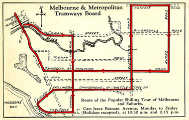
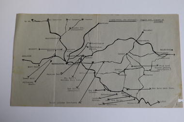
Drawing - Digital Image, Shilling Tour Map, 1927
Map shows the route of the Shilling Tour Map, using Y469 - shows the direction of travel and departure times from Batman Ave. Destination City 5th Edition notes that the services with the tram commenced in June 1927.Yields information about the MMTB's 1927 Shilling tour of Melbourne.Digital Image of an MMTB Map.trams, tramways, y class, tours, tourist trams, tourist trips, tram 191 -
 8th/13th Victorian Mounted Rifles Regimental Collection
Photograph - Mensford 13th ALH
1389 Trooper Samuel Mensford of Hay NSW. The 13th Light Horse Regiment (AIF) was raised at Broadmeadows Victoria in March 1915. Following service at Gallipoli the regiment was broken up with squadrons going to France as Divisional Cavalry Squadrons of 2nd, 4th and 5ht Divisions. The regiment was reformed as firstly 1st Anzac Corps Mounted Troops and lather Australian Corps Mounted Troops. Black and white photograph of Trooper S Mensford 13th Light Horse, mounted on his horse. He is holding his rifle and is wearng a steel helmet." 13 ALH Trooper France 1917 "world war one, wwi, mensford, 13th, light horse -
 Bendigo Military Museum
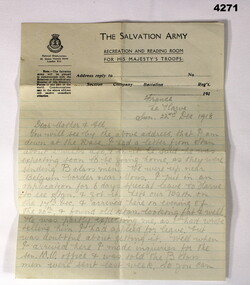
Letter - PERSONAL LETTER WW1, 22.12.1918
Letter is from Alf Ferris to his family at home, written from Le Harve France on 22.12.1918. Refer Cat No 4183.3P for his service detailsHand written letter in pencil on Salvation Army letter head, second page is on plain paper, written from France.letters, salvation army, personnel, military -
 Melbourne Legacy
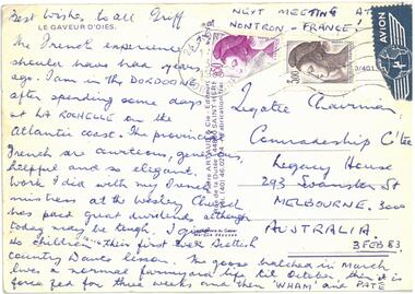
Postcard - Document, postcard, 1983
A postcard to the Comradeship Committee when a Legatee was travelling in France. The postcard was addressed to the Legatee Chairman of the Comradeship Committee. Dated 3 Feb 1983. It is signed GRIFF, it says: The French experience I should have had years ago. I am in the DORDONGE after spending some days at LA ROCHELLE on the Atlantic coast. The provincial French are courteous, generous, helpful and so elegant. Work I did with my French mistress at the Wesley Church has paid great dividends although today may be tough. I give 40 children (aged 10-14) their first ever Scottish Country dance lesson. The goose hatched in March lives a normal farmyard life till October, then it is force fed for three weeks and then 'WHAM' and PATE. Next meeting at Norton - France! Best wishes to all - GRIFF.A record of a Legatee travelling and relating experiences back to his comrades in Melbourne.Colour postcard of a Frenchman.Printed "Le Gaveur D'oies." French postage stamps. Handwritten text in blue pen.comradeship, legatee -
 Bacchus Marsh & District Historical Society
Map, The Unique Advertising Combine, The Unique Combine's New Map of the Shire of Bacchus Marsh, 1890
This map was one of a number of similar maps produced for advertising purposes by a company called, 'The Unique Advertising Combine'. The company was located in Melbourne on Queens Walk. A brief item in the Bacchus Marsh Express newspaper on 29 March 1890 , page 2, indicated that subscribers to the Bacchus Marsh Express could obtain a copy of this map in the next issue of that newspaper. On the map is the detail that it was compiled by W.H. Bonney from official records supplied by D. A. Little, hire Secretary, (of Bacchus Marsh Shire).This map with its accompanying illustrations of local businesses and shops in Bacchus Marsh is an important documentary and visual snapshot of the town and district of Bacchus Marsh in the later part of the nineteenth century. The illustrations for some of the local businesses are the only known visual record of those particular buildings. The map is a rare surviving example of the material produced by The Unique Advertising Combine. Another similar example for the Shire of Mornington is held by the State Library of Victoria,A map of the Shire of Bacchus Marsh produced in March 1890. The map is mounted on a board and enclosed within a timber frame. The map includes an inset detail section showing the central part of the township of Bacchus Marsh including the main shopping and business streets. Land holdings with the first European land holders names indicated are included on the map. Rivers, creeks, major roads and the railway line are also shown on the map. Around the edges of the map are illustrated advertisements mostly for Bacchus Marsh businesses but which also includes some businesses located in Melbourne. maps bacchus marsh shire, shops bacchus marsh -
 Greensborough Historical Society
Map - Map (Copy), C. Hodgkinson, District Surveyor et al, Parish of Yan Yean 1856: Village site during construction of the Yan Yean Reservoir, 1978
Copy of map part Sec. 13, Parish of Yan Yean 1856, Map 3, Village site... Scale: 8 chains to 1 inch. Drawn by C. Hodgkinson, District Surveyor, redrawn by A. R. Blair 1978. 1 p. photocopy of map. yan yean reservoir, yan yean -
 Eltham District Historical Society Inc
Book, Melway Great Melbourne street directory including Geelong, Phillip Island Healesville, Bellarine & Mornington Peninsulas, 1998
... maps ...25th edition. Coloured detailed maps accessed by a street or location index. Cover: (Includes) New Southbank map including Crown Complex, enlargements of Footscray and Kensington, bike paths, walking tracks & horse trails, latest public transport information, South east Australia tours maps, Vic Roads new route numbers, map of Australia1 atlas (22, 772 p.) : col. maps ; ISSN 03113957streets, maps, roads, melbourne -
 Bendigo Military Museum
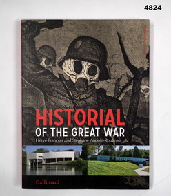
Booklet, FRANCOIS Herve and AUDOIN-ROUZEAU Stephanie, Historial of The Great War, 2018
Museum Exhibition - "The Musee de Peronne" the overall conflict. "Musee de Thiepval" Battle of the Somme.Soft cover book, Soft cover, cardboard, red and white colour print on front, spine and back. Front cover - illustrated top copy of illustration in black and white of figure with gas mask. Bottom colour photographs of the two museums. 32 pages paper and lightweight cardboard with foldout pages. Illustrated black and white; and colour photographs, posters, paintings, displays, maps. Front and back and papers - illustrated, sepia tones, handwritten letters.Museum Exhibition - "The Musee de Peronne" the overall conflict. "Musee de Thiepval" Battle of the Somme.books, museums, ww1 -
 Bendigo Military Museum
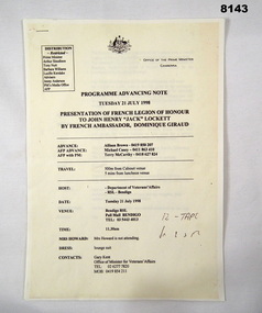
Programme - PRESENTATION OF FRENCH LEGION OF HONOUR, Office of the Prime Minister, pre 21.7.1998
This is a copy of the original produced by the Office of the Prime Minister of Australia. The presentation of the French Legion of Honour to John Henry Lockett (Jack) by the French Ambassador His Excellency Dominique Giraud was to be held in the main Hall of the Soldiers Memorial Institute Pall Mall Bendigo on 21.7.1998. (Now Bendigo Military Museum) Refer Cat No 8144 re the program on the day, Cat No 8145.10P for photographs.Program copy of original, 3 pages stapled, all print in black on yellow background. Details the presentation of the French Legion of Honour by the French Ambassador Dominique Giraud to John Henry Lockett on 21 July 1998. Covers arrivals, guests, timings, dress, speeches with the main guest being the Australian Prime Minister Mr John Howard.brsl, smirsl, french, legion of honour -
 Greensborough Historical Society
Map, Australia. Department of Minerals and Energy, Melbourne, topographic map, 1970_
A topographic map of Victoria with Melbourne as the centre. Provisional edition showing contours in feet. International map of the world [scale] 1:1,000,000. Prepared by the Department of Minerals and Energy, Canberra in 1970.A pre-metric map, shows the Hume Highway travelling through towns such as Seymour and Benalla, now by-passed by the Hume Freeway.Map, printed in colour on one side.victoria - maps -
 Marysville & District Historical Society
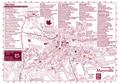
Map (Item) - Information map, Michael Hampton, 2000
An information map of the township of Marysville. This map was produced by McNamara Country Real Estate in 2000. The artist who drew the map was named Michael Hampton.An information map of the township of Marysville.MICHAEL HAMPTON/ 2000 VERSION 1:2/ 01/01marysville, victoria, australia, tourist map, information map, mcnamara country real estate, michael hampton -
 Bacchus Marsh & District Historical Society
Map, 'Map of Darley' circa 1877-1897
This map shows the early laid out streets and roads for the village of Darley and the main roads and streets in the central area of the township of Bacchus Marsh. The date of the map is not known. Landmarks indicated on the map including the Anglican Church in Church Street (Gisborne Road), opposite the Presbyterian Church, and the Baptist Church at its pre-1898 Main Street location suggest the map is dated between 1877 and 1897. Landholders names can be seen on some of the allotments of land marked in this map, including the names Clifton, Cosgrove, O'Hagan, McFarlane, Nagle, O'Hagan, Simpson and Vallence.A single page paper map showing the village of Darley and the township of Bacchus Marsh. Scale 10 chains to 1 inch. The map is pasted into a bound volume containing 76 maps or plans in total. High resolution digital image stored on BMDHS computer network. darley victoria maps, bacchus marsh victoria maps -
 Robin Boyd Foundation
Slide, Robin Boyd, 1950
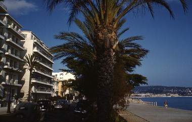
Penleigh Boyd, Robin and Patricia Boyd's son, writes “Prior to 1950 Robin, like most other amateur or hobby photographers, took black and white printed photographs. The oldest slides date from 1950 when Robin and Patricia travelled to Europe on Robin’s Robert Haddon Travelling Scholarship.” In 1948 Robin Boyd was awarded ‘joint first place’ in the Robert Haddon competition for his design of Mildura art gallery. The scholarship helped fund their first overseas trip. Robin and Patricia were passengers on the Greek ship “Cyrenia” departing in May 1950, passing through the Suez Canal and landing in Genoa five weeks later. For six months, they travelled extensively throughout Europe (predominantly driving themselves) - France, Italy, United Kingdom, Sweden, Denmark, Germany, Austria, Switzerland and Spain.Colour slide in a mount. Foreshore, Nice, FranceNice / Foreshore (All Handwritten)haddon travelling scholarship, haddon, robin boyd, slide -
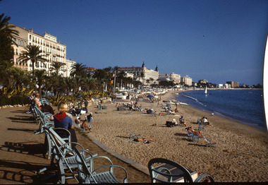 Robin Boyd Foundation
Slide, Robin Boyd, 1950
Penleigh Boyd, Robin and Patricia Boyd's son, writes “Prior to 1950 Robin, like most other amateur or hobby photographers, took black and white printed photographs. The oldest slides date from 1950 when Robin and Patricia travelled to Europe on Robin’s Robert Haddon Travelling Scholarship.” In 1948 Robin Boyd was awarded ‘joint first place’ in the Robert Haddon competition for his design of Mildura art gallery. The scholarship helped fund their first overseas trip. Robin and Patricia were passengers on the Greek ship “Cyrenia” departing in May 1950, passing through the Suez Canal and landing in Genoa five weeks later. For six months, they travelled extensively throughout Europe (predominantly driving themselves) - France, Italy, United Kingdom, Sweden, Denmark, Germany, Austria, Switzerland and Spain.Colour slide in a mount. Beach, Cannes, FranceCannes / Beach (All Handwritten)haddon travelling scholarship, haddon, robin boyd, slide -
 Warrnambool and District Historical Society Inc.
Map - Tourist Map Collection: Warrnambool & District Tourist Maps, Philprint, Warrnambool
This is a diverse collection of Tourist Maps for the Warrnambool & District area. [.1] From information on this guide it dates from the mid 1970's. It appears to not have been commercially printed and includes details of attractions no longer operating in Warrnambool such as Warrnambool Aquarium and the Oasis Reptile Park and Zoo. [.2] Commercially printed Warrnambool tourist map (c mid 1980's) surrounded by advertisements for local businesses. [.3] Commercial printed December 1991 tourist map of Warrnambool and District includes a competition entry form [.4] Commercially printed tourist map aimed at children [.5] Walking map of Warrnambool and District [.6] Commercially printed Warrnambool tourist map (c mid 1980's) surrounded by advertisements for local businesses. This collection of maps from the mid 1970's to early 1990's gives an insight into what was available to assist tourists find their way around Warrnambool and District. They include advertisements for business operating during this period and include lists of available accommodation, eateries, and tourist attractions.[.1] Tourist Attractions In and Around Warrnambool two foolscap pages with two sides of type written information of local and district attractions. There is a Warrnambool City map with points of interest marked and a hand drawn district map; [.2]Commercially printed grid map of Warrnambool City surrounded by advertisements from local businesses. Reverse side has a district map and a map of the Warrnambool CBD surrounded by advertising. [.3] Brochure including small grid maps of Warrnambool and district listing accommodation providers and places of interest. Stylised blue & bright green design of Norfolk pines and sea. [.4] Children's treasure hunt map to Warrnambool There are two examples, one with blue edging (Jan 1986) and one with red edging (Aug 1993) Both have a circular logo with a stylised whale and lighthouse [.5] Walking maps of Warrnambool blue printed photo of four tourists walking coastline on the front cover. [.6] Commercially printed grid map of Warrnambool with a bright yellow inset of Warrnambool CBD main shopping centre. The map is surrounded by advertising for local businesses.warrnambool, tourist maps, warrnambool businesses, warrnambool accommodation -
 4th/19th Prince of Wales's Light Horse Regiment Unit History Room
Christmas Card, 1917
A small, coloured Christmas card showing the rising sun badge, a sketch of purple pansies and the words" To greet you and wish you a Merry Christmas" on the front. There is a green woven cord down the spine holding the internal sheet on which is written "Christmas, 1917. Did you hear a whispered "Coo-ee". Did you feel a clasping hand, When the Christmas bells were ringing, In Australias Golden Land? For in my thoughts I send them you, From the shatter'd fields of war, That we might meet, greet as in dear days of yore; And O how low distant distant seem those times, When you and I were near, Oh would the Southern Cross and you were shining on me here. From 2987 Sapper C A Roney 1st Aust Divn Signal Coy AIF France"As describedchristmas card, ww1, france -
 University of Melbourne, Burnley Campus Archives
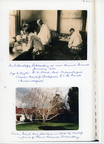
Photograph - Sepia and black and white photocopies, The Fruit World of Australasia, Charles French Jnr, 1929-1933
Donated by Charles French's daughter. Information about Charles French Jnr., Biologist in charge of the Plant Research Laboratory. Photocopies of photographs. (1) Sepia "In Entomology Laboratory at new Science Branch January 1933 Left to Right K.M. Ward, Asst. Entomologist, Charles French Jnr. (Biologist), R.T.M. Pescott (Entomologist)." (2) C. "Silver Birch tree planted in 1929 by myself in front of Plant Research Laboratory." (3) "Plant Research laboratory, Burnley Gardens, Burnley. Opened 1929." (4) Photocopy of newspaper cutting in The Fruit World of Australasia 1/5/33, "Some of the Staff at the Vict. Government Plant Research Laboratory, Burnley" (named). (5) Other information about French from unnamed source. charles french jnr., biologist, plant research laboratory, entomology laboratory, science branch, k.m. ward, assistant entomologist, r.t.m. pescott, entomologist, birch tree -
 Bendigo Military Museum
Photograph - PHOTOGRAPH, FRAMED WW1, Wayne Eels, C.2008/09
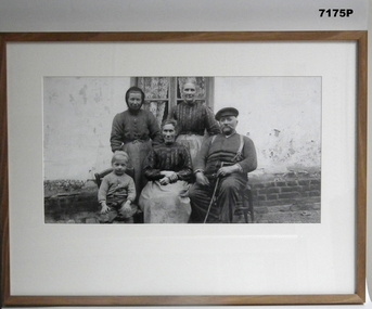
The Grinton Collection. Unknown French Family. Refer Cat No. 1280 for Jack Grintons service history.Photograph - framed. Photograph - black and white photograph on paper depicts a group portrait of five civilians, two women standing and boy, women and man seated in front. Background exterior building wall and window. Frame - timber, light varnish finish, Perspex front, cardboard backing."Group 2: Burden of War". "K. Group portrait of five French civilians."framed accessories, camera on the somme, ww1, 38th bn, 'grinton -
 Bacchus Marsh & District Historical Society
Map, Allotments in the Village of Rowsley, Parish of Gorrocburkghap, County of Grant c.1856
Rowsley is a locality 11 kilometers south-west of Bacchus Marsh. The date of this map is uncertain. A very similar map held by the State Library of Victoria (SLV) contains slightly more information than this copy and is dated as an 1856 map. SLV reference: 'Allotments in the Village of Rowsley, Parish of Gorrocburkghap, County of Grant', by T. Nixon, Assistant Surveyor, May 1856 ; Surveyor General’s Office, July 18 1856 (lithographed by R. Meikle). (1856). Melbourne: Surveyor General’s Office. MAPS 820 BJE 1837- ROWSLEY 1856. A single page paper map. A cadastral map of the Village of Rowsley in Victoria, showing numbered land allotments. 57 allotments are shown on the map and some areas set aside as reserves. Allotments 8, and 10-16 are outlined in red ink and allotment 9 has a cross in red ink on it. The map is pasted into a bound volume containing 76 maps or plans in total. High resolution digital image stored on BMDHS computer network. rowsley victoria history, rowsley victoria maps -
 Peterborough History Group
Document - Survey of Town of Peterborough, 2014
Proclamation of road district and Shires, Map of original town blocks and ad for SaleDisplays original township settlement and layoutPhotocopies, copies of maps, peterborough history, peterborough 3270 -
Beechworth Honey Archive
Map- Chiltern/Barnawartha
(4x) Map centred on Chiltern and Barnawartha. Shows Murray River, Hume Highway, Chiltern- Barnawartha Rd and Chiltern- Rutherglen Rd. Scale 1:50,000. Paper is white on back, yellow on front.Map labelled 'Albury series R652' Some markings in red and blue on some maps- blue writes '74-75'map, chiltern, barnawartha, paper, beechworth honey -
Victorian Aboriginal Corporation for Languages
Book, RMW Dixon, Australian languages: their nature and development, 2002
Very comprehensive technical linguistic introduction to the Australian language family, a follow-up to Dixon?s ?The Languages of Australia? (1980). Numerous maps, isoglosses, tables, comparative grammar, phonology, semantics, etc. 1. The language situation in Australia 2. Modelling the language situation 3. Overview 4. Vocabulary 5. Case and other nominal suffixes 6. Verbs 7. Pronouns 8. Bound pronouns 9. Prefixing and fusion 10. Generic nouns, classifiers, genders and noun classes 11. Ergative/?accusative morphological and syntactic profiles 12. Phonology 13. Genetic subgroups and small linguistic areas 14. Summary and conclusion.Mapslinguistics, language surveys -
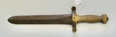 Lara RSL Sub Branch
Short Sword, French 1831 Pattern Artillary Shord Sword
French 1831 Pattern Artillery Short Sword A French 1831 pattern brass handle dismounted artillery mans short sword, marked Talabotts Paris with black leather brass mounted scabbard. Blade, length 49cm, total length 64cm The French 1816-1831 sword was based on ancient sculptural depictions of the Roman gladius, the standard sword of the Roman legionaries. Both sword and scabbard are in very good condition.Short Sword Brass Handle with 26 cm Blade French 1831 Pattern Artillery. Based on ancient sculptural depictions of the Roman gladius, the standard sword of the Roman legionaries.Stamped number on center of the guard of the hilt is 770. There is some marks also on center of the guard on the opposite side but not readable.french short sword 1831, brass handle, metal blade -
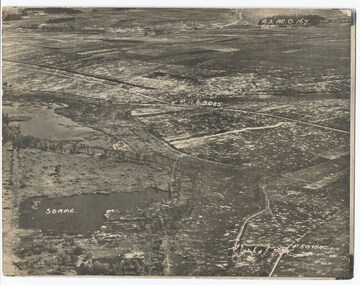 Melbourne Legacy
Photograph - Photo, Aerial view of the Somme
An aerial photo of the Somme Swamp in France during World War One. There are coordinates or numbers in some areas. Was with 11 other photos of World War One that had been mounted on board for display at Legacy House at some stage. When they were taken off display they were put in the archive cabinets. The founding legatees all served in World War One so these photos would have been of significant places for them. (see 01888 to 01899)Photos from World War One that would have been significant to the founding legatees.Sepia photo of the Somme battlefield in France during World War One.world war one, france, somme -
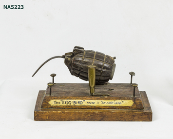 Whitehorse Historical Society Inc.
Artwork, other - French Art WWI, "The Egg Bird"
Example of WWI French Art, using found material.Contemporary label, Whimsical article made from weapons (hand grenade + Bullet casing) + uniform buttons.Example of WWI French Art consisting of hand grenade "bird" mounted on wooden base using .303 calibre cartridges as pivot surrounded by 4 British Buttons as "fence".Contemporary label: The Egg-Bird" found in "No-Man's Land"french art - mounted with contemporary label.. -
 Glenelg Shire Council Cultural Collection
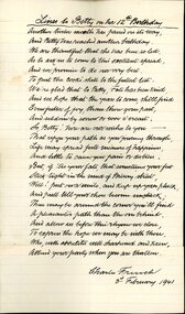
Literary work - Birthday Poem for Betty Vivian, Charles French, 03/02/1941
Charles French owned a shop on Percy Street in Portland.Poem written for Betty Vivian on her 12th birthday, by Charles French on the 3rd of February 1941. White lined paper, handwritten in black ink. Slight discolouration to paper. Lines to Betty on her 12th Birthday / Another 12 months has passed on its way, / And betty has reached another birthday. vivian family records, poem, written word, birthday -
Beechworth Honey Archive
Map- Beechworth
Compiled from 1972 aerial photography. Printed in 1977.Map centred on Beechworth. SHows Beechworth toen, Wooragee, Reids Creek, Woolshed Falls and Lake Kerford. Scale 1:25,000 Printed colour on paper.Map labelled Reids Creek. No. 8225-3-1.map, beechworth, wooragee, reids creek, woolshed falls, lake kerford, aerial photography, paper, beechworth honey -
Whitehorse Historical Society Inc.
Map, Shire of Boroondara, Parish of Nunawading, 1904
... Maps ...Photocopy of printed map extending from Camberwell to Middleborough Road.Photocopy of printed map extending from Camberwell to Middleborough Road. note on verso: From a book of maps dated 1904.Photocopy of printed map extending from Camberwell to Middleborough Road. maps, shire of boroondara, parish of nunawading -
 Mission to Seafarers Victoria
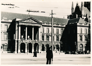
Photograph, Allan Charles Quinn, Rouen City Council, 05 June 1949
This photograph is one of a series taken by Allan Quinn while travelling through France in mid-1946. There are several letters relating to this journey.This is a photograph from the Allan Charles Quinn collection which is a collection of letters and photograph depicting aspects of life at sea for a young man in the era immediately following World War II.A black and white photograph of the facade of the City Council in Rouen, France, taken on the 5th of June, 1949. There is a narrow white boarder around the image.On reverse: ROUEN 5-6-49 handwritten in blue ink. Below this is the mark "ItI" in pencil.allan-quinn, photograph, rouen, france -
 Bendigo Military Museum
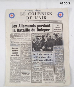
Newspaper - NEWSPAPERS, FRENCH, Le Courrier De L'air, 28th October 1943
The newspaper written in French detailing Allied actions in Europe, distributed by the RAF to French speaking allies. Part of the Frederick Gardner Davey DFC No 410533 RAAF collection. Refer Cat No 3536P for his service record..1) & .2) Four page newspaper written in French, RAF symbol in colour on top LH & RH corner of page 1.Information in black type with B & W photographs..1) Top of page 1 “Orleans 5/6 - 11 - 43”, hand written in black ink.newspapers, french, allies