Showing 11149 items
matching re-survey
-
 Anglesea and District Historical Society
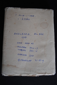
Map, Royal Australian Survey Corps, Anglesea, Victoria, 1954
Anglesea, Victoria [cartographic material] produced by Royal Australian Survey Corps. Colour; Scale [1:63,360] 1 mile to 1 inch; transverse Mercator projection; Sheet No. 866, Zone 7. Two stamps: 1. Rankine and Dobbie Pty Ltd. 2. Authorised for sale / Price 2/- / By Department of the Army Original date: November 1928.(See above)anglesea map, topographic map -
 Bendigo Historical Society Inc.
Book - FORTUNA COLLECTION: LANSELL'S FORTUNA
Produced by Army Survey Regiment, Bendigo. Describes grandeur of Fortuna and the vision and enterprise that saw the complex of mansion , gardens and mine buildings develop on the site. Twelve pagesArmy Survey Regimentbendigo, house, fortuna villa, fortuna, george lansell, ballerstedt, sandhurst, bendigo -
Clunes Museum
Document (Item), DEPARTMENT OF LANDS AND SURVEY, RENEWALS GARDEN LICENCE 5/
RECEIPT BOOK DEPARTMENT OF LANDS AND SURVEY. LICENCE TO ENTER UPON CROWN LANDS NOT EXCEEDING IN AREA ONE ACRE, AS SPECIFIED HEREUNDER, FOR PURPOSES OF GARDEN AND RESIDENCE. FEE PER ANNUM 5 / O (FIVE SHILLINGS) FIFTY CENTSlocal history, local government, council, licence, garden -
 Bendigo Military Museum
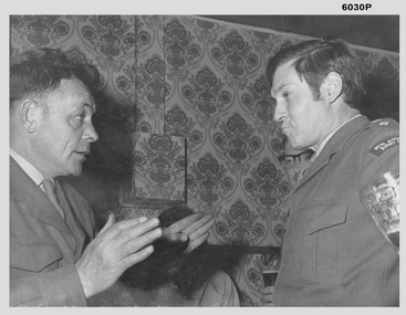
Photograph - AHQ Survey Regiment - LTCOL DR Ridge and SSGT G Haswell Circa 1972-1975, 1975
Photograph taken in the Sergeants Mess, Fortuna Villa circa 1972-1975 whilst LTCOL DR Ridge was the Commanding Officer of the Army Survey Regiment and SSGT G Haswell was a stores NCO. WO2 Szentirmay (in the background) was a Lithographic Technical Warrant Officer. 4233 LTCOL DR Ridge was commissioned from the ranks and served from 1946 - 1975, he was Commanding Officer of the Army Survey Regiment from 1972-1975. 310207 SSGT G Haswell served 1950- 1978 after a British Army career, 14613 WO2 T Szentirmay BEM served 1958-1980 after an Eastern European Army career.Black and White photograph of LTCOL DR Ridge and SSGT G Haswell Circa 1972-1975 taken at the Sergeants Mess at Fortuna Villa, Bendigoroyal australian survey corps, rasvy, fortuna, army survey regiment, army svy regt, asr -
 Glenelg Shire Council Cultural Collection
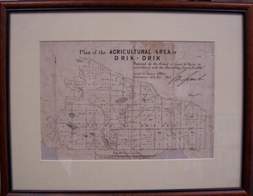
Map - Map of Drik-Drik, 1865
Displayed at History House.Print of map pasted onto board, mounted and framed under glass. Buff-coloured mount. Mahogany stained moulded wood frame, black inner frame.Front: Plan of the Agricultural Area of Drik-Drik L.2556/Prepared by the Board of Lands and Works in accordance with the "Amending Land Act 1865". Lands and Survey Office, Melbourne 11th May 1865. (printed, upper centre). Back: Duncan Hedditchmap, drik drik, plan, geography, cartography -
 Bayside Gallery - Bayside City Council Art & Heritage Collection
Map, Department of Crown Lands and Survey et al, Moorabbin, County of Bourke, Government Roads, 1920
The cadastral map of the Parish of Moorabbin in Victoria (L.6104) shows parish boundaries and land ownership 1920 when Sandringham was a Town. The government roads have been coloured in red pencil.moorabbin, county of bourke, map, plan, land subdivision, land titles, foreshores, hampton, beaumaris, highett, cheltenham, department of lands and survey, land owners, cartographic material, brighton, sandringham, town of sandringham, government roads -
Bendigo Historical Society Inc.
Plan - JAMES LERK COLLECTION: BENDIGO HISTORIC SOCIETY FEATURE PLAN OF VICTORIA HILL AREA COMPILED BY AHQ SURVEY REGIMENT MAY 1971
BHS CollectionPaper plan produced for the Bendigo Historic Society Victoria Hill Area Compiled by AHQ Survey Regiment May 1971 plan with black print, has been rolledAHQ Survey regiment -
 Bendigo Military Museum
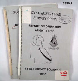
Administrative record - Royal Australian Survey Corps Report on Operation Aright 85 / 86 1 Field Survey Squadron 1986, 1986
Operation ARIGHT 85 was mounted by 1 Fd Svy Sqn 14 May to 8 Aug 1985 and 1 May to 15 May 1986. In the 1:250,000 SG54-15 Rutland Plains map area. In addition 18 X 1:50 000 maps were field completed.6359.1 Copy 1. 6359.2 Copy 2. A4 Cardboard cover, grey, plastic ring binder, report, diagrams, maps, plastic ring binder.royal australian survey corps, 1 field survey squadron, 1fd svy sqn, rasvy, fortuna, army survey regiment, army svy regt, asr -
Moorabbin Air Museum
Newspaper (item) - Aviation - A Survey By Peter Finn - A survey by The Australian Tuesday March 2 1971
-
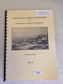 Stawell Historical Society Inc
Book, Norman Taylor, Geological Survey of Victoria No3, Geological Survey of Stawell, 1875-1876
stawell mining -
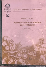 Beechworth Honey Archive
Publication, Australian National Residue Survey - Report on the Australian National Residue Survey Results 2001-2002 (Dep of Agriculture Fisheries & Forestry), 2002
Soft cover book slightly larger than A5 siz, green spine with an off white cover with pencil drawings of cattle sheep, pig. seafood, chicken, eggs, sunflowers & wheat 93 pages -
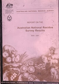 Beechworth Honey Archive
Publication, Australian National Residue Survey - Report on the Australian National Residue Survey Results 2000-2001 ( Dept of Agriculture, Fisheries and Forestry - Australia), 2001
Soft Cover book slightly larger than A5 size, Dark Green spine with an off white cover & pencil drawings of a pig, fruit, seafood, chickens, eggs,sunflower grain, cattle, sheep 74 pages -
Glenelg Shire Council Cultural Collection
Photograph - Photograph - aerial view of railway between Heywood and Rennick, 03/05/1952
Black and white aerial photographs (aerial survey record print) of the railway line between Heywood and Rennick (S.A. border) Taken for Victorian Railways, May 1952. Some photos have annotations later added to the front of the image in penVictorian Railways aerial survey record print of the railway line between Heywood and Rennick (S.A. border) Black and white, white vertical strip on imageBack: 'Heywood - Rennick 21389 - 19660 261m 3c ' - all black ink. Purple VR aerial survey stamp. '3 May 1952' - black stampvictorian railways, train track, transport -
Glenelg Shire Council Cultural Collection
Photograph - Photograph - aerial view of train track between Heywood and Rennick, 03/05/1952
Black and white aerial photographs (aerial survey record print) of the railway line between Heywood and Rennick (S.A. border) Taken for Victorian Railways, May 1952. Some photos have annotations later added to the front of the image in penVictorian Railways aerial survey record print of the railway line between Heywood and Rennick (S.A. border) Black and white, white vertical strip on imageBack: 'Heywood - Rennick 21453 - 19724 267m 19c ' - all black ink. Purple VR aerial survey stamp. '3 May 1952' - black stampvictorian railways, train track, transport, travel -
 Bayside Gallery - Bayside City Council Art & Heritage Collection
Map, Department of Lands and Survey, Land under the control of the City of Sandringham, 1962
The cadastral map showing land under the control of the City of Brighton in 1962.map, plan, foreshores, sndringham, hampton, beaumaris, cheltenham, department of lands and survey, cartographic material, moorabbin, black rock, street map, city of sandringham, board of lands and works -
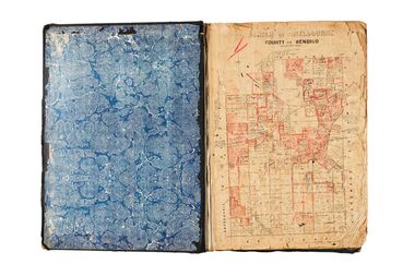
 City of Greater Bendigo - Civic Collection
Administrative record - Land Sales, Department of Lands and Survey et al, 1929
This type of album was created by agents auctioning and selling land.Large portfolio style album with green cloth cover bound with three large metal pins. One hundred and then pages with thirty three Department of Lands and Survey maps pasted in. Index page. Maps have handwritten notes and markings throughout in pencil and pen. Covers the Counties of Bendigo, Rodney, Talbot, Gunbower, Gladstone, Tatchera and Karkarooc, Shires of East Loddon and Huntly and Swan Hill District. -
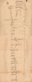 Bendigo Historical Society Inc.
Document - VIRGINIA MINE
Transverse section of the Virginia mine on the Garden Gully line of Reef at Eaglehawk, being Plate V of Bulletin No. 47 from the Geological Survey Office at BendigoGeological Survey Office Bendigogold, goldfields, virginia mine, gold mines, garden gully line of reef, virginia mine , eaglehawk -
Clunes Museum
Administrative record - BOOK, DEPARTMENT OF LAND AND SURVEY, LICENCE
RECEIPTS ISSUED BY DEPARTMENT OF LANDS AND SURVEY TO CUT AND TAKE AWAY WOOD. ISSUED EACH QUARTER. LOCALITY - ALL CROWN LANDS, NOT BEING IN STATE FORESTS OR RESERVES FOR ANY SPECIAL PURPOSE. GUM, STRINGYBARK, BOX, MESSMATE AND OTHER KINDS OF EUCALYPTUS TIMBER EXCEPTING RED GUM AND IRON BARK.BLUE CARDBOARD COVERED BOOK CONTAINING TIMBER LICENCES FOR ORDINARY WOOD, COSTING 5/- .1 ISSUED 1886 - 1887 RECEIPT NUMBERS 181901 - 181925 .2 ISSUED 1885 - 1886 RECEIPT NUMBERS 185276 - 185300 DETAILS OF NAMES OF PERSONS LICENCES ISSUED TO ATTACHED TO BACK OF BOOKSlocal history, receipt books, early citizens, wood licences -
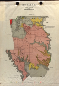 Federation University Historical Collection
Map - Plan, E.J. Dunn, Bungal County of Grant Parish Plan
E.J. Dunn was the surveyor of this parish plan.Colour geological plan of Bungal in the County of Grant, Victoria. The areas circled in red ar craters.plan, bungal, bungeltap, black horse co. egerton, egerton, mount egerton, sister rose shaft, south learmonth co, kerrit bareet, bungaeeltap, yaloak, eastern moorabool river, corong, bungal station preemptive right, lal lal, western moorabool river, moorabool rover, borhoneychurck, mount egerton battery, bungal creek -
 Federation University Historical Collection
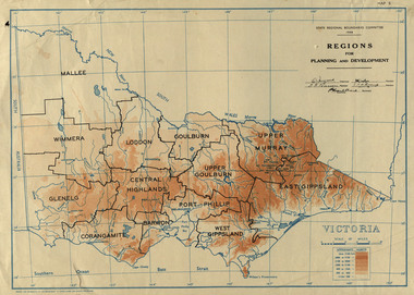
Map, Victoria: Regions for Planning and Development, 1944, 1944
This map was produced for the State Regional Boundaries Committee Two colour map of Victoria showing the regions for planning and development. The regions are Central Highlands, Mallee, Wimmera, Glenelg, Corangamite, Barwon, Loddon, Goulburn, Upper Goulburn, Upper Murray, East Gippsland, West Gippsland, Port Phillip.central highlands, mallee, wimmera, glenelg, corangamite, barwon, loddon, goulburn, upper goulburn, upper murray, east gippsland, west gippsland, port phillip, victoria, m4486 -
 Federation University Historical Collection
Plan, Burrumbeep, 1884, 16/10/1884
Auctions of Crown land were introduced in the Colony of Victoria from 1851 to encourage settlers to occupy and work the land. Many squatters purchased land at auction at the upset (minimum) price of £1 per acre. In some areas where demand was high, such as the goldfields, the price realised at auction was much more. Land was put up for sale in the study area on the Burrumbeep run in May 1855, on the Lexington run in 1857, and on the Gorrinn run in 1858. (http://www.ararat.vic.gov.au/library/document/thermatics.pdf, accessed 27 January 2015) For 70 years or more, Yalla-y-Poora, Burrumbeep, Edgarley, Mount William and Narrapumelap ranked in the leading wool producers in Victoria. 1 Stud owners at Yalla-y-Poora, Eurambeen, Burrumbeep and Challicum crossed merino sheep with sheep descended from John Macarthur's Camden Park in New South Wales. (http://www.ararat.vic.gov.au/library/document/thermatics.pdf, accessed 27 January 2015) In what was to become the Ararat Mining Division, gold was discovered in May 1854 on the Burrumbeep run at a place that became known as Pinky Point on the Mount William goldfield. By 21 June 1854, between 600 and 1,000 people had arrived. (http://www.ararat.vic.gov.au/library/document/thermatics.pdf, accessed 27 January 2015)\ Town allotment plan for Burrumbeep. Merrymbuela, Borung, Lexington and Langi Logan are neighbouring areas. The plan includes the Burrumbeep Pre-Emptive Right (Roger and Wright); licensed land holders including Stephen Young, John Carroll, William Walsh, Thomas Purcell, Martha M. Bond, Colin Johnson, John Charles Webb, Henry Withycombe, William Henry Barbridge, John Wall, Thomas Flatelly, William Jenkinson, Elisia Radford, V. Radford, Denis Byrne, George Cook. Land holders included Andrew Maloney, Richard Wingfield Harrocks, W. Sporton, Terence Lynch, F. S. Falkiner, A. Millman, H. Morris, George Upham, J. McCLure, S. Fletcher, W. Parker, Thomas Myers, William wright, W.C. Winter, C. Wordman, Oliver A. Winter This plan is associated with former Ballarat School of Mines student Richard Squire (1875-6) Gift of the Squire FamilyVerso written in pencil - Plan of Burrembeep Ararat Burrembeep Araratburrumbeep, corrinn, langi logan, merrymbuela, lexington, ararat, roger & wright, cook, rogers, upham, george upham, ross, parsans, morris, johnson, withycoombe, colin johnson, falkiner, dsporton, john carroll, donald gordon, denis bryne, maurice dooley, martha bond, william harricks, \william wingfield harricks, william l.c. harricks, michael houlihan, thomas purcell, martin ryan, michael cody, fletcher, mccaw, w. parker, j.m. clow, elisia radford, thomas radford, thomas myers, barbridge, e. wilde, j. wall, flatelly, g. wardman, w.c. winter, david ball, jenkinson, ballarat school of mines, richard squire, squire -
 Federation University Historical Collection
Plan, Smythesdale, County of Grenville, 01/12/1892
This plan is associated with former Ballarat School of Mines Student Richard Squire (1875-1876). Gift of the Squire FamilyA plan showing the Borough of Smythesdale, Smythesdale, Browns and Scarsdale, allotments, water reserve, Timber reserve, Nintingbool Pre-emptive Right, Reserve for public gardens, Reserve for Cricket Ground, Reserve for Reservoirsmythesdale, scarsdale, browns, yarrowee, carngham, samuel barlett, sheridan, wrigley, p. land, r. simpson, d. davis, nintingbool, mclachlan, a. mclachlan, c. taylor, w. c. smith, d. davies, w. williams, m. jones, t. mcgurk, r. selkirk, a. mooney -
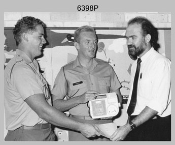 Bendigo Military Museum
Photograph - 2 FD Svy Sqn Childrens Hospital Charity Presentation, Sydney, NSW, 1989
This photograph of a charity donation from 2 FD Svy Sqn to the Director of the Prince of Wales Childrens Hospital, was taken in Sydney in 1989. CPL Bob Hopper and SPR Bob White presented a Kangaroo Pump, used for feeding sick children to the Director that was purchased with leftover Regimental funds when the unit closed down. This photograph of a charity donation from member of 2 FD Svy Sqn to the Director of the Prince of Wales Childrens Hospital was taken in Sydney in 1989. The black & white photograph was printed on photographic paper and is part of the Army Survey Regiment’s Collection. The photograph was scanned at 300 dpi. .1) - Photo, black & white, 1989. L to R: SPR Bob White, CPL Bob Hopper, Director of the Prince of Wales Childrens Hospital..1P – annotated in red pen ‘2 Fd, presenting the Director of the Prince of Wales Childrens’ Hospital with a Kangaroo Pump, used for feeding sick children. The pump was purchased with leftover Regimental funds when the unit closed down.’royal australian survey corps, rasvy, army survey regiment, army svy regt, 2 fd svy sqn -
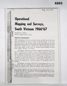 Bendigo Military Museum
Booklet - Operational Mapping and Surveys - South Vietnam 1966/67, Royal Australian Survey Corps
Report written for the "Australian?" Army Journal. This report describes in some detail the Australian 1st Topographical Survey Troop from its initial formation in Oct 1965 through its deployment to South Vietnam in May 1966 and its Operational activities during 1966/67 in support of the 1st Australian Task Force.A4 booklet, stapled in top left corner. "SSgt Learmonth" written on front cover.royal australian survey corps, rasvy, fortuna, army survey regiment, army svy regt, asr, 1st topographical survey troop, south vietnam -
 Federation University Historical Collection
Map, Ballaarat Gold Field, 1861, 21/10/1861
A party of surveyors camped by Yuille's Swamp (later Lake Wendouree) and surveyed the countryside for a map to be produced by the Geological Survey of Victoria. In November 2004 the Central Highlands Regional Library presented a special edition of 200 copies of the 1861 map reproduced from a copy in their collection. Original geological map of Ballarat showing property, waterways, mines, churches, schools, water races, and garden reserves. It was compiled and drawn from the surveys of Mining Surveyors Davidson, Fitzpatrick and Cowan.Compiled & Drawn from the Survey of Mining Surveyors Davidson, Fitzpatrick and Cowan & the Plans in the Surveyor General's Office by J. Brahe, 21st October 1861. R. Brough Smyth, Secretary for Mines. The Honourable J.B. Humffray, M.L.A. Commr of Mines.ballarat, map, davidson, robert brough-smyth, fitzpatrick, cowan, yuille's swamp, public garden reserve, manure depot, black hill, ballarat east, old post office hill, pennyweight hill, claytons hill, golden point, mining, railway, cricket ground, swamp creek, cemetery, sludge reserve, bakery hill, gaelic church, juvenile reformatory, orphanage, specimen hill, eureka lead, cattle yard hill, dalton's flat, chinese village, poverty hill, railway reserve, little bendigo diggings, pound reserve, allied armies, flour mill, agricultural reserve, marsh, survey reserve, survey corps, white flat, yarrowee, yarrowee creek, brache, j. brache, survey, ballaarat gold field 1861 -
 City of Greater Bendigo - Civic Collection
Administrative record - Land Sales, A. J. Mullet Government Printer, 1927
This type of album was created by agents auctioning and selling land.Large portfolio style album with black cloth cover bound with three large metal pins. Blue marbled pastedown endpapers. Seventy nine pages, seventy five with Department of Lands and Survey maps attached. No index page. Maps have handwritten notes and markings throughout in pencil and pen. Covers the Counties of Bendigo, Rodney, Gladstone and Talbot and Parishes of Kerang, Salisbury, Mandurang and Tarnagulla. Includes a hand written note on William Wallace & Co letterhead. city of bendigo commerce -
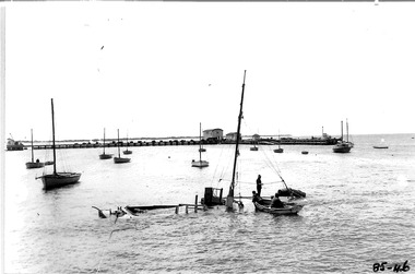 Queenscliffe Maritime Museum
Photograph - Sinking of the Ports & Harbour launch "Flinders", Photographer unknown, Photographs
Photos of the Ports & Harbour launch "Flinders' at anchor prior to sinking.Realism, historical1. Envelope of Notes 2. Page 1 of 3 Notes re Photos 46 to 54. 3. Page 2 of 3 Notes re Photos 46 to 54. 4. Page 3 of 3 Notes re Photos 46 to 54. 5. Photo of sunk Flinders and Bass towing it 6. Reverse of photo showing notes.On the reverse - " P2A49 - Couta boats in background - Sunk boat - FLINDERS - P&H survey launch - 1953 - Ports & Harbours survey launch with tow rope - P&H Survey Launch BASS" -
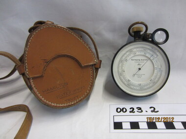 Wannon Water
Aneroid, ER Watts & Son
Possibly used for surveying pipe linesSurveying Aneroid Compensated -
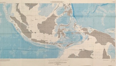 Federation University Historical Collection
Map - Geological, U.S. Government Printing Office, Bathymetric Map of the Indonesian Region: Folio of the Indonesian Region Map I-875-A, 1974, 1974
Map was prepared on behalf of the Government of Indonesia, The United Nations Economic Commission for Asia and the Far East, the Agency for International Development and the U.S. Department of State in cooperation with the Geological Survey of Indonesia. The area covered shows the islands and seas from Latitude 12 degree North to 16 degrees South and Longitude 90 degrees to 148 degrees. Various water features are also named.Large map showing the Indonesian area - islands and seasLongitude and Latitude are shown. Major / Capitol cities indicated. Names of those responsible for the productionindonesia, united nations economic commission, department of state, geological survey, latitude, longitude, government of indonesia -
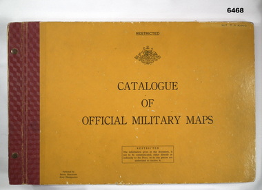 Bendigo Military Museum
Album - Australian Army Catalogue of Official Military Maps, Survey Directorate, Army Headquarters, 1962
This is a catalog of Australian Military maps prior to 1 Nov 1962. Later Catalogs exist showing much more map coverage, but this example is valuable as it shows the limit of Australian military mapping existing at the time. This Catalog was donated by Stephen King nephew of the owner 52878 SGT JD King who served at the Army Headquarters Survey Regiment, Fortuna, Bendigo in the 1960's.Large book, heavy orange cover, red binding, held together with Chicago screws. Commonwealth of Australia badge on cover contains diagrams and text.Hand written "SGT TD KING" top right hand cornerroyal australian survey corps, rasvy, fortuna, army survey regiment, army svy regt, asr