Showing 23443 items
matching emu-creek
-
 Kiewa Valley Historical Society
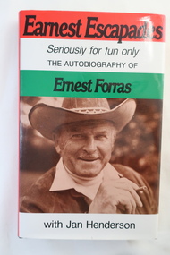
Book - The Autobiography of Ernest Forras, Earnest Escapades Seriously for fun only The autobiography of Ernest Forras with Jan Henderson
Ernest migrated from Hungary in January 1951 and helped bring commercial development to Australia's fledgling snowfields. He was keen to find Alpine employment, eventually importing ski and sports gear. This book covers his time in Hungary and his visits to the Alpine Ski Resorts - an insight into the early years of skiing in Australia.Ernest visited Falls Creek on the Bogong High Plains in 1951 and describes the area on pages 66 to76 from the point of view of an Hungarian migrant. He visited Falls Creek because his brother had got work on Kiewa Hydro Electric Ssheme.Hard dark brown cover book with dust cover coloured in red, white and green with title in black and a photo of Ernest Forras below. It consists of 190 pages. After page 54 and between Part one and Two, there are 18 pages of photos on photographic paper.Written in shaky writing on inside first page "To Debbie / From Hungary With Love / Ernest Forras 2002 / Mt Beautyernest forras, australian ski resorts from 1951, hungary pre 1951 -
 Kiewa Valley Historical Society
Photos: Skiers at Falls Creek x2 copies
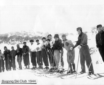
Bogong Ski ClubBogong Ski Club - SECV employeesBlack and white photo of 14 skiers from Bogong Ski Club 1944bogong ski club -
 Kiewa Valley Historical Society
Photos - Falls Creek - C. Stals Collection
See letters enclosed with photos from c1960sHistorical development of Falls Creek and social changes re status of women in business.3 groups of photos each with letter of explanationfalls creek, carol stals -
Kiewa Valley Historical Society
Safety Helmet - SECV
Safety helmets were used by workers on the Kiewa Hydro Electric Scheme.While working at McKay Creek Power Station, Alec Menzies was hit on the head with a rock and fell about 10 metres. Luckily he survived, and after a stint in hospital he was admitted to what was known as the Turtle Club. Ref. Mal Menzies, his son.Cream coloured safety helmet with 3 ridges at the top from back to front. It is light in weight. Inside has an attached cloth band with 'netting' of 6 straps attached to band and an inner band. Underneath the shade, at the front, it is coloured green.Centre front - a sticker - "Member/ Turtle Club. Inside: embossed an oval shape with 'hard/soiled' in its middle and underneath also embossed E.D. Bullard Co. / S.F. U.S.A.safety helmet, mckay creek power station, alec menzies, turtle club -
 Kiewa Valley Historical Society
Tapes - x10 Native Orchids and Birds, Lake Guy
Orchids, birds on the Bogong High Plains and surrounds and the SECV construction on the Kiewa Hydro Electric Scheme were topics of interest for the workers living there. Taping them would have been an interesting hobby for Jack Farrell.Jack Farrell (1920s - 1990s) worked for the State Electricity Commission of Victoria on the KHES. He worked in the workshop and lived on the river side of Simmonds Creek Road. x10 tapes of orchids, birds and Lake Guy etc. and 1 Panasonic Battery Pack VW-VBC4E for movie camera.The battery has a sticker on it "$99.00"orchids, birds, kiewa hydro electric scheme, movies of native flora, movies of birds -
 Kiewa Valley Historical Society
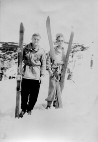
Photo - Skiers at Falls Creek
Small black and white photo of 2 unidentified skiers standing with skis and wearing the fashion of the day -
 Kiewa Valley Historical Society
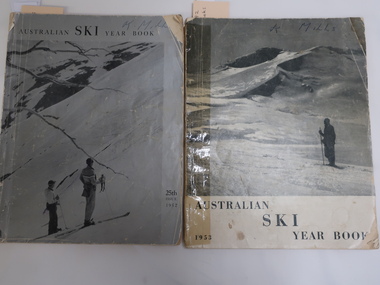
Books - Australian Ski Year Books 1952 and 1953, Australian Ski Year Book 1952 and 1953
In the early 1950s snow skiing was becoming more popular as indicated by these two books of 94 pages covering the snow fields in N.S.W., Victoria and Tawmania. The first publication was limited to the Kosciusko Alpine Club in 1928. The 1952 edition being the 25th issue. Due to the construction of the Kiewa Hydro Electric Scheme many SECV employees had access to the Bogong High Plains including Falls Creek. These books are of historical value as indicated by the advertisements for the resorts, the equipment in the snow eg. tows, skis and clothes being used at the time, the results of ski races, etc. The accommodation has also developed and attracted a variety of people. The articles include disasters, people involved in the sport and overseas updates. In the 1952 book relevant pages for the Bogong High Plains and Falls Creek are pages 36, 38, and 68-69. In the 1953 book relevant pages are 62 and 71-72 and for aborigines 66 - 69Both books have a greyish photo as a cover with the title and year. Each book has 94 pages of soft paper. The books consist of advertisements, a Contents page and articles. Photos and diagrams are in black and white. On the front covers is written: "K. Mills"bogong high plains, skiing, falls creek, aborigines -
 Kiewa Valley Historical Society
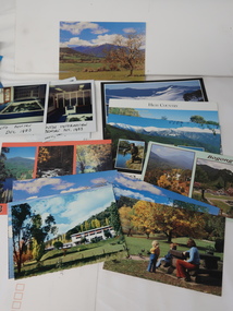
Photos, Postcards - Kiewa Valley
Mt Beauty township, at the head of the Kiewa Valley, is situated at the foot of Mt Bogong. The town was established by the State Electricity Commission of Victoria during the construction of the Kiewa Hydro Electric Scheme on the High Plains.Mt Beauty is a popular tourist resort. The main highway from Mt Beauty to the Bogong High Plains is most picturesque throughout the year. During the winter months, Falls Creek provides access to Falls Creek Ski Village for snow sports. Tawonga, 6.5 km north of Mt Beauty, is famed for its trout fishing and camping on the Kiewa River. Deciduous trees make a show of colour during Autumn. The postcards are of historical value showing photos taken at an earlier time.The postcards can be compared to the attractions of the time as they do not include cycling (mountain bikes and road bikes), snow boarding, gliding and paragliding. Advertising for tourism has also changed as attractions are now available on-line. 1. 9 Coloured Photos of Bogong (5) and Visitors Information Centre display (4) 2. Two fold out coloured sets of postcards "Mt Beauty and the Kiewa Scheme", "Mt. Beauty Victoria" 3. x10 Coloured postcards Mt Beauty, Kiewa Valley, Bogong 4. x6 Coloured postcards High Country and Bogong Villagepostcards kiewa valley -
 Kiewa Valley Historical Society
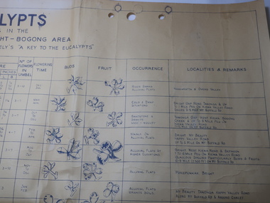
Chart - Eucalypts occurring in the Wangaratta, Bright, Bogong Area
On the 2nd April 1948 the SECV noted the Eucalypts in the area of the Kiewa Hydro Electric Scheme. The Forestry Officer was an employee of the SECV and would have given advice in his area of expertise. This chart may have been used with regard to logging and enabling those involved in the identification of the trees.The last row has the heading "Localities and Remarks" and includes those found around the KHES eg. "Tawonga Gap. West Kiewa. Bogong Creek & up to 5 mile peg on Kiewa Valley Road. 7-12 Mile on Mt Buffalo Rd." Also significant to compare these eucalypts with current locations and numbersLarge chart with black print and pictures on yellowing thick paper. The chart has 18 headings across the top and 24 eucalypts listed under the headings.Printed in the bottom right hand corner "Compiled by W.G. Chandler / Forestry Officer / State Electricity Commission of Victoria / 2-4-48"forestry, w.g.chandler, eucalypts in bogong area -
 Kiewa Valley Historical Society
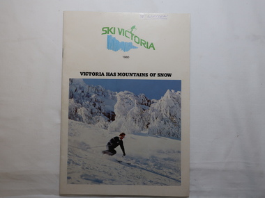
Magazine - Ski Victoria 1980
The introduction: "Skiing has been a sport in Victoria since the turn of the century. It has only been popular since the 1950s however, when the Alpine areas were opened up to commercial development."Employees of the SECV skied on the High Plains during the construction of the KHES. In 1946 the first lodge was approved by the SEC at Falls Creek. See Falls Creek pages 6-11 for details of amenities in 198048 pages held by 2 staples. 1980 Issue. Front Cover "Victoria has mountains of snow". In color - skier in front of trees laden with snow.Front cover in pen and underlined "J. Watson"falls creek ski resort, snow sport -
 Kiewa Valley Historical Society
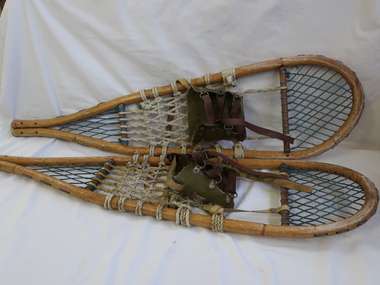
Snow Shoes - Pair
Snow shoes enable the wearer to walk on the snow without sinking into it. These snow shoes are an earlier variety as there is no plastic.Used at Falls Creek on the Bogong High PlainsLong basket (webbing) framed with cane into an oblong attached at the back and wider at the front. Leather/material straps are in the middle for the boot to be attached.snow shoes -
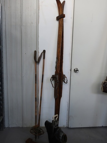 Kiewa Valley Historical Society
Skis, Boots, Stocks
Skis and snow equipment has changed / developed over the years from the 1940s to the present day. The collection of skis etc. is an example of the changesThe Kiewa Valley is below the Bogong High Plains with the ski resort Falls Creek 30 km away. The local people are involved with the ski industry providing ski equipment to the visitors. A variety of skis, stocks and boots used for cross country skiing and downhill skiing.skis, ski boots, ski stocks, cross country skiing, downhill skiing -
 Kiewa Valley Historical Society
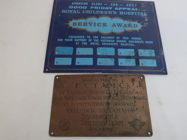
Plaques - Awards
1. The Good Friday Appeal is held annually in Victoria with proceeds being raised for the Royal Children's Hospital. 2. Yamaha, a Japanese Company, encouraged Australian businesses to use their products. In this case the Snowmobile.The Kiewa Valley took part in the Good Friday Appeal and Yamahs snowmobiles were used at Falls Creek. 1. Blue metal plaque with holes in each corner and pale blue print informing details of Award . There is a thin gold line around the circumference. 2. Gold metal plaque with holes in each corner and black print informing details of the award.Includes: 1. Good Friday Appeal / Royal Children's Hospital Service Award. 2. Presented to F.C.T.A.M.C by Yamaha Motor Company, Japan. and Milledge Bros. Melbourne re Yamaha / Snowmobile / testing team / July 1972good friday appeal, royal children's hospital, yamaha co. japan, snowmobile falls creek -
 Kiewa Valley Historical Society
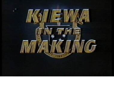
VHS Video - Kiewa, Kiewa Compile, Date compiled 25th Nov. 1998
The construction and development of the Kiewa Hydro scheme showing its construction and the people in work and play during its duration. It also shows the development of Mt Beauty and Bogong townships. The films were used as News Reels, Tourist Information and Entertainment.This item provids a snap shot in time (1990) when the Kiewa Valley was still relatively under populated and holiday houses owned by city bound workers was still relatively insignificant. As more and more holiday makers retire to a small but friendly region(Kiewa Valley and Mount Beauty) the increase in visitor numbers will affect the local rural bush scene more and more. The changes that will occur (in time) can be measured against the scenes presented in this video. The additional resources provided by the State Electricity Commission of Victoria of "alpine bush" fire control and management, together with an ongoing educational scheme for school children in learning about what constitutes the Alpine country's unique environment, are a very important offshoot, benefitting to both the communities within the Kiewa Valley and regional Victoria.This VHS tape is stored within its own plastic cover which has a front side Titled "KIEWA in the MAKING". The VHS tape is nestled within a formed inner structure which not only prevents the tape from moving to and fro but also unnecessary intrusion of foreign particles. Titled "Kiewa Compile" with 4 short films titled 1. Kiewa in the Making 2. Kiewa Capers 3. It only seems like yesterday 4. Kiewa.kiewa, hydro electricity, state electricity commission of victoria, construction towns, 1940s 1960s, mt beauty, bogong, falls creek, clover power station, mckay power station, bill sutton, news film, construction workers, early machinery -
 Kiewa Valley Historical Society
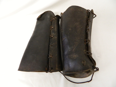
Gaiters Riding, Late 19th Century
These gaiters where used circa 1800's to mid 1900's, by horse riders "cattle men" to protect their shins and long trousers against wear and tear. They were used rather than having expensive boots damaged. Gaiters were a lot easier to fasten and clean than boots. They were used in the Kiewa Valley and the High Plains grazing areas.These gaiters were part of a cattleman's "out fit". The Gaiters were easily cleaned and did away with expensive riding boots. They were used throughout the valley and high plains areas both by horse riders herding cattle and the recreational rider of both sexes. After the 1950s more recreational riders from Melbourne ventured onto the high plains and not so rugged mountain slopes. Small settlements such as Mount Beauty, Bogong village and Falls Creek provided a secure backdrop for short term horse back adventures. The increasing pressure of city life provided a greater flow of stressed out city dweller to find the peace and quiet that city life does not have. Horse riding preceded the modern trail bikes and other recreational vehicles of the late 1900s. Thick leather tapered gaiters with six metal Hooks and Leather lacing through metal eyelets. All bar two eyelets have a metal reinforced punch holes. Left gaiter missing most of lacing.horse, country, leather, gaiters, high, grazing, cattlemen, laces, studs -
 Kiewa Valley Historical Society
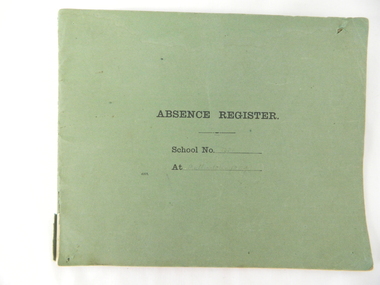
Register School Administration, Absence Register School No. 2539 Mullindolingong, circa 1910
Historical look (early 20th century) at the administrative requirements for the running of a small country school. The level of accountability was limited to a monthly report and a visit from the District Inspector. This was still in the era where paper reporting was utmost and faster electronic reporting had still to be implemented.The significance of this register is that it highlights the need in the early 1900s for travelling time, to and from, the duties required at a small country town to be detailed closely for a bureaucracy that was relatively isolated within the larger cities of Australia. Decentralisation of not only government but also of industry had not as yet entered the Australian environment. This register also shows that the written word was clearly hand scribed and thereby a more personal form of communication. This was still in the age where you " can tell a lot about a person from their handwriting" Lucy Goonan was Leonie Prime's relation and came from Glen Creek to teach at Mullindolingong School for a couple of years. None of the other names are 'known' names from the district.Green coloured cardboard backed book with two large staples holding each page at the left side of the spine Each page of has been folded in half from a 51cm overall length to produce each individual page of the register. This method of production of the book provides 25 double sided pages. Markings on cover " Absence Register, School No........ At ......." Markings on inside cover " ABSENCE REGISTER." Underneath this heading there are six explanatory and conditional usage. Each page is printed with the heading ABSENCE REGISTER and underneath "Roll No. 191(part of initial year reference), Record No. Name of Teacher Position Date of Absence Cause of Absence No. of times absent from beginning of year, total number of days absence and remarks requirements staff /reason/time taken during the period 1923 to 1950. Each page was printed with only three numbers of the calender year 191-.This was so that each year could be manually inserted.teachers absence register small school administration, mullindolingong school 1923 -1950 -
 Kiewa Valley Historical Society
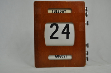
Calendar Desk Perpetual, circa mid 1950s
This item appears to be a calendar which was in use for a multiple clientele office e.g. post office, commercial office or bank, school or educational administration area, small government office or hospital administration in the Kiewa Valley or its region. The time this item was first used, electrical or battery powered desk and office calendars did not exist for semi isolated rural regions. These type of perpetual calendars not only looked impressive but were not affected by power shortages. This was a time when not all of Victoria was adequately supplied by power. This item is quite relevant to the Kiewa Valley as it demonstrates that the time before the Hydro electricity generators where built (Mount Beauty to Falls Creek), power supplies were not keeping up to the ever increasing demand from city and rural customers. This item was in a period before mass produced automated date and time pieces were available and hand operated date and time pieces were both in a social and commercial sphere a necessity.Wooden box (varnished) with three openings (on the front) detailing ,the day(Monday to Sunday), the date (1st to 31st) and the month (January to December). On the right side of the calendar box are two winding screws (RHS 6 steel) for each opening. These permit the scrolling of the information i.e. day, number and month. This ability results in a desk calendar which is perpetual. On the back there is a steel (screwed on) hanger with a slot for wall screw.perpetual calendar, office calendars, desk calendars, desk furniture -
 Kiewa Valley Historical Society
Book - Non Fiction History, The Kiewa Story, circa 1993
This book provides in chronological order the development of the Kiewa Hydro-electricity scheme from the first concept (1911) to final construction work (1961). It covers the first attempt to utilise the power of the Victorian Alps water system. It started from a private syndicate and developed to the current State Electricity Commission of Victoria. The incentive for the Hydro scheme was to make money and not as an alternative to the carbon producing coal fired power plants. These coal fired power plants were increasing in numbers to service an ever increasing demand made by population expansion, especially in cities and large rural settlements. This demand spiraled up after World War II when there was a tremendous spike in immigration numbers due to refugees and displaced persons in Europe. The ability to utilise the untapped water provided by the winter snow fields, for a higher yield in electricity, was a powerful incentive to overcome the physical hardships in this remote Alpine region. Future power requirements may initiate the re-installation of the other two power stations(Pretty Valley and Big Hill) covered in original Scheme. This publication not only covers the development of the Kiewa Valley region with respect to population (within a socio-economical framework) but also the subtle but yet strong physical changes of a relatively pristine alpine region. The demands that an ever growing regional population places on the environment is clearly documented in print and black and white photographs. The working and living conditions of those who constructed and gave life to this hydro scheme is well documented in this book. It may be viewed as spartan now but was relevantly good at that moment in time, especially for those workers fleeing a devastated European environment. The successful planning and consideration to minimising any intrusion upon the natural alpine forests and high plains can viewed as an example (compared to the Tasmanian Hydro schemes) of how future hydro schemes (an inevitable requirement) will proceed. Most rural towns (in the early 1900s) were built by unencumbered rural based citizens, with the exception of Mount Beauty and Falls Creek. These two settlements were brought into life by a State (Victorian) Authority for a specific function and program. They were a gated community, that is, only open to construction workers involved with the hydro scheme. All facilities within these communities were provided by the State Electricity Commission of Victoria. The impact on the social, financial and individual independency of the community, by the transition from the S.E.C .environment to one of local government (Shire of Bright), had in some cases a severe impact.This hard covered book has a green cover with pictures on the front and back covers. The front cover has a coloured picture of a snow covered Mount Bogong taken from the opposite mountain range. The valley between both ranges has a whisk of mist over it. At the bottom of this picture are three black and white photographs covering the construction of the Kiewa Hydro - Electricity Scheme. On the back cover is a photograph, (black and white) detailing the Bogong village and Junction dam containing lake Guy. The inside front cover is a black and white photograph which details the construction of the West Kiewa tailrace tunnel during April 1951. The inside back cover is a black and white photograph of the concrete pour at the Clover Dam circa 1952. All photographs and sketches are in black and white. The pages are approximately 160 g/m2 and those which have photographs are on gloss paper.Book spine: "The Kiewa Story Graham Napier Geoff Easdown" alongside this is a white framed circle with white spokes radiating out and underneath in white lettering SECkiewa valley, hydro scheme, victorian alpine region, electricity generators, graham napier, geoff easdown -
 Eltham District Historical Society Inc
Ledger, Eltham Road District. Assessment for the Year ending Oct. 14th, 1858, 1857c
The Eltham Roads Board was established in 1856. This is a unique significant record of early settlers in the Shire of Eltham. One of 6 early rate books. This is among the oldest items in the EDHS collection. An article in the Eltham and Whittlesea Shires Advertiser Friday 21 Nov 1941 Page 5 titled: District's Early History states: "The first rate book which is still in existence at the Shire Office is for the year ending October 14, 1858 and is probably the best record possible to indicate the development of the district. At the time properties were rated as follows: Cultivated land. 6d. per acre; pasture land, 1d. per acre: estimated annual value of buildings, etc., 6d in the (pound). The total amount of rate recorded for the year was (pounds)153/14/8. Properties were described as being situated at Lower Plenty, Yarra Yarra, Eltham, Lower Eltham, Kangaroo Ground, Yarra Flats, Diamond Creek and the Yarra."Ledger with printed columns: Number, Name of Occupier, Description, Where situated, Cultivated land, Pasture land, Estimated annual value of buildings, Rate, Remarks. Ledger filled out by hand with 152 entries (not alphabetically arranged). A number of blank pages are included. Copy re-bound in green hard leather look card by Arnall & Jackson Pty Ltd Brunswick, 1968 Inside cover includes a compliments slip taped to the cover from Arnall & Jackson Pty Ltd. with handwritten inscription: "Ian, I hope the hysterical society doesn't get historical about this". Organised 1968 I. Maynard Inside cover includes pasted printed note: RATE OF ASSESSMENT AS FOLLOWS: Cultivated land 6d per acre Pasture land 1 per acre Estimated Annual Value of Buildings, &c., 6d. in the Pound eltham roads board, rate book, rate payers, transaction, pioneers, settlers, 1858, assessment ledger, eltham road district, public records office victoria (prov), rate books, shire of eltham archives -
 Eltham District Historical Society Inc
Ledger, Eltham Road District. Assessment for the Year ending Oct. 14th, 1859, 1858c
The Eltham Roads Board was established in 1856. This ledger includes the signature of Road Board Secretary and Collector Wingrove, a significant person in Eltham's early history. This is a unique significant record of early settlers in the Shire of Eltham. One of 6 early rate books. This is among the oldest items in the EDHS collection. An article in the Eltham and Whittlesea Shires Advertiser Friday 21 Nov 1941 Page 5 titled: District's Early History states: "The first rate book which is still in existence at the Shire Office is for the year ending October 14, 1858 and is probably the best record possible to indicate the development of the district. At the time properties were rated as follows: Cultivated land. 6d. per acre; pasture land, 1d. per acre: estimated annual value of buildings, etc., 6d in the (pound). The total amount of rate recorded for the year was (pounds)153/14/8. Properties were described as being situated at Lower Plenty, Yarra Yarra, Eltham, Lower Eltham, Kangaroo Ground, Yarra Flats, Diamond Creek and the Yarra."Ledger with printed columns: Number, Name of Occupier, Description, Where situated, Cultivated land, Pasture land, Estimated annual value of buildings, Rate, Remarks, Arrears collected, excused, unoccupied, uncollected and amount actually collected. Ledger filled out by hand with 173 entries (not alphabetically arranged). A number of blank pages are included. Inside cover includes pasted printed note: RATE OF ASSESSMENT AS FOLLOWS: Cultivated land 6d per acre Pasture land 2d per acre Unalienated Pasture Land 8d per Acre Estimated Annual Value of Buildings, &c., 6d. in the Pound eltham roads board, rate book, rate payers, transaction, pioneers, settlers, wingrove, 1859, assessment ledger, eltham road district, public records office victoria (prov), rate books, shire of eltham archives -
 Eltham District Historical Society Inc
Ledger, Eltham Road District. Assessment for the Year ending Oct. 14th, 1860 (Version 1), 1859c
The Eltham Roads Board was established in 1856. This is a unique significant record of early settlers in the Shire of Eltham. One of 6 early rate books. This is among the oldest items in the EDHS collection. An article in the Eltham and Whittlesea Shires Advertiser Friday 21 Nov 1941 Page 5 titled: District's Early History states: "The first rate book which is still in existence at the Shire Office is for the year ending October 14, 1858 and is probably the best record possible to indicate the development of the district. At the time properties were rated as follows: Cultivated land. 6d. per acre; pasture land, 1d. per acre: estimated annual value of buildings, etc., 6d in the (pound). The total amount of rate recorded for the year was (pounds)153/14/8. Properties were described as being situated at Lower Plenty, Yarra Yarra, Eltham, Lower Eltham, Kangaroo Ground, Yarra Flats, Diamond Creek and the Yarra."Ledger with printed columns: Number, Name of Occupier, Description, Where situated, Cultivated land, Pasture land, Estimated annual value of buildings, Rate, Remarks, Arrears collected, excused, unoccupied, uncollected and amount actually collected. Ledger filled out by hand with 177 entries (not alphabetically arranged). A number of blank pages are included. Inside cover includes pasted printed note: RATE OF ASSESSMENT AS FOLLOWS: Cultivated land 6d per acre Pasture land 2d per acre Unalienated Pasture Land 8d per Acre Estimated Annual Value of Buildings, &c., 6d. in the Pound eltham roads board, rate book, rate payers, transaction, pioneers, settlers, wingrove, 1860, assessment ledger, eltham road district, public records office victoria (prov), rate books, shire of eltham archives -
 Eltham District Historical Society Inc
Ledger, Eltham Road District. Assessment for the Year ending Oct. 14th, 1860 (Version 2), 1859c
The Eltham Roads Board was established in 1856. This is a unique significant record of early settlers in the Shire of Eltham. One of 6 early rate books. This is among the oldest items in the EDHS collection. An article in the Eltham and Whittlesea Shires Advertiser Friday 21 Nov 1941 Page 5 titled: District's Early History states: "The first rate book which is still in existence at the Shire Office is for the year ending October 14, 1858 and is probably the best record possible to indicate the development of the district. At the time properties were rated as follows: Cultivated land. 6d. per acre; pasture land, 1d. per acre: estimated annual value of buildings, etc., 6d in the (pound). The total amount of rate recorded for the year was (pounds)153/14/8. Properties were described as being situated at Lower Plenty, Yarra Yarra, Eltham, Lower Eltham, Kangaroo Ground, Yarra Flats, Diamond Creek and the Yarra."Ledger with printed columns: Number, Name of Occupier, Description, Where situated, Cultivated land, Pasture land, Estimated annual value of buildings, Rate, Remarks, Arrears collected, excused, unoccupied, uncollected and amount actually collected. Ledger filled out by hand with 177 entries (not alphabetically arranged). A number of blank pages are included. This version was slight changes to version one. Inside cover includes pasted printed note: RATE OF ASSESSMENT AS FOLLOWS: Cultivated land 6d per acre Pasture land 2d per acre Unalienated Pasture Land 8d per Acre Estimated Annual Value of Buildings, &c., 6d. in the Pound eltham roads board, rate book, rate payers, transaction, pioneers, settlers, 1860, assessment ledger, eltham road district, public records office victoria (prov), rate books, shire of eltham archives -
 Eltham District Historical Society Inc
Ledger, Eltham Road District. Assessment for the Year ending Oct. 14th, 1861, 1860c
The Eltham Roads Board was established in 1856. This is a unique significant record of early settlers in the Shire of Eltham. One of 6 early rate books. This is among the oldest items in the EDHS collection. An article in the Eltham and Whittlesea Shires Advertiser Friday 21 Nov 1941 Page 5 titled: District's Early History states: "The first rate book which is still in existence at the Shire Office is for the year ending October 14, 1858 and is probably the best record possible to indicate the development of the district. At the time properties were rated as follows: Cultivated land. 6d. per acre; pasture land, 1d. per acre: estimated annual value of buildings, etc., 6d in the (pound). The total amount of rate recorded for the year was (pounds)153/14/8. Properties were described as being situated at Lower Plenty, Yarra Yarra, Eltham, Lower Eltham, Kangaroo Ground, Yarra Flats, Diamond Creek and the Yarra."Ledger with printed columns: Number, Name of Occupier, Description, Where situated, Cultivated land, Pasture land, Estimated annual value of buildings, Rate, Remarks, Arrears collected, excused, unoccupied, uncollected and amount actually collected. Ledger filled out by hand with 185 entries (not alphabetically arranged) and summary section. A number of blank pages are included. Inside cover includes pasted printed note: RATE OF ASSESSMENT AS FOLLOWS: Cultivated land 6d per acre Pasture land 2d per acre Unalienated Pasture Land 8d per Acre Estimated Annual Value of Buildings, &c., 6d. in the Pound eltham roads board, rate book, rate payers, transaction, pioneers, settlers, 1861, assessment ledger, eltham road district, public records office victoria (prov), rate books, shire of eltham archives -
 Eltham District Historical Society Inc
Ledger, Eltham Road District. Assessment for the Year ending Oct. 14th, 1862, 1861c
The Eltham Roads Board was established in 1856. This is a unique significant record of early settlers in the Shire of Eltham. One of 6 early rate books. This is among the oldest items in the EDHS collection. An article in the Eltham and Whittlesea Shires Advertiser Friday 21 Nov 1941 Page 5 titled: District's Early History states: "The first rate book which is still in existence at the Shire Office is for the year ending October 14, 1858 and is probably the best record possible to indicate the development of the district. At the time properties were rated as follows: Cultivated land. 6d. per acre; pasture land, 1d. per acre: estimated annual value of buildings, etc., 6d in the (pound). The total amount of rate recorded for the year was (pounds)153/14/8. Properties were described as being situated at Lower Plenty, Yarra Yarra, Eltham, Lower Eltham, Kangaroo Ground, Yarra Flats, Diamond Creek and the Yarra."Ledger with printed columns: Number, Name of Occupier, Description, Where situated, Cultivated land, Pasture land, Estimated annual value of buildings, Rate, Remarks, Arrears collected, excused, unoccupied, uncollected and amount actually collected. Ledger filled out by hand with 184 entries (not alphabetically arranged) and summary section. A number of blank pages are included. Inside cover includes pasted printed note: RATE OF ASSESSMENT AS FOLLOWS: Cultivated land 6d per acre Pasture land 1/2d per acre Unalienated Pasture Land 1/28 per Acre Estimated Annual Value of Buildings, &c., 6d. in the Pound eltham roads board, rate book, rate payers, transaction, pioneers, settlers, 1862, assessment ledger, eltham road district, public records office victoria (prov), rate books, shire of eltham archives -
 Eltham District Historical Society Inc
Ledger, Eltham Road District. Assessment for the Year ending Oct. 14th, 1863, 1862c
The Eltham Roads Board was established in 1856. This is a unique significant record of early settlers in the Shire of Eltham. One of 6 early rate books. This is among the oldest items in the EDHS collection. An article in the Eltham and Whittlesea Shires Advertiser Friday 21 Nov 1941 Page 5 titled: District's Early History states: "The first rate book which is still in existence at the Shire Office is for the year ending October 14, 1858 and is probably the best record possible to indicate the development of the district. At the time properties were rated as follows: Cultivated land. 6d. per acre; pasture land, 1d. per acre: estimated annual value of buildings, etc., 6d in the (pound). The total amount of rate recorded for the year was (pounds)153/14/8. Properties were described as being situated at Lower Plenty, Yarra Yarra, Eltham, Lower Eltham, Kangaroo Ground, Yarra Flats, Diamond Creek and the Yarra."Ledger with printed columns: Number, Name of Occupier, Description, Where situated, Cultivated land, Pasture land, Estimated annual value of buildings, Rate, Remarks, Arrears collected, excused, unoccupied, uncollected and amount actually collected. Ledger filled out by hand with 181 entries (not alphabetically arranged) and summary section. A number of blank pages are included. Inside cover includes pasted printed note: RATE OF ASSESSMENT AS FOLLOWS: Cultivated land 6d per acre Pasture land 1/2d per acre Unalienated Pasture Land 1/28 per Acre Estimated Annual Value of Buildings, &c., 6d. in the Pound eltham roads board, rate book, rate payers, transaction, pioneers, settlers, 1863, assessment ledger, eltham road district, public records office victoria (prov), rate books, shire of eltham archives -
 Eltham District Historical Society Inc
Photograph, George W. Bell, Eltham Railway, 1960c
Black and white photograph of railway line near Eltham trestle bridge c.1960.railways, bridges, eltham, diamond creek, george w bell collection -
 Eltham District Historical Society Inc
Photograph, George W. Bell, Flood Eltham early 1950's, 1950c
Black and white photograph of flood remains Eltham early 1950s.floods, eltham, diamond creek, george w bell collection -
 Eltham District Historical Society Inc
Photograph, George W. Bell, Smiths Dam, Eltham, 1961, 1961
Black and white photograph of concrete dam on Smith property Karingal Drive Eltham 1961karingal drive, st helena road, d.b smith, eltham west drain, karingal creek, st helena creek, dams, george w bell collection -
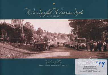 Eltham District Historical Society Inc
Book, Warrandyte Historical Society, Wonderful Warrandyte - A Portrait by Valerie Polley, 2014
The Warrandyte Historical Society aims to collect, preserve and present the town's history. This books draws on the archival and memorabilia resources of the Society and other sources to paint a portrait of the township, its landscape, buildings, organisations and community.Warrandyte holds a significant place in Victoria's gold mining, art and settlement history.ISBN 9780992429102warrandyte, anderson's creek -
 Eltham District Historical Society Inc
Photograph, Ruth H. Pendavingh, Reconstruction of Main Road from Main Road Bridge to Mount Pleasant Road, Eltham, 1984
Two colour photographs1984, bridge construction, diamond creek (creek), eltham south, main road, main road bridge, road construction, antoinette boulevard, mount pleasant road