Showing 11254 items
matching tea-tree
-
 Melbourne Legacy
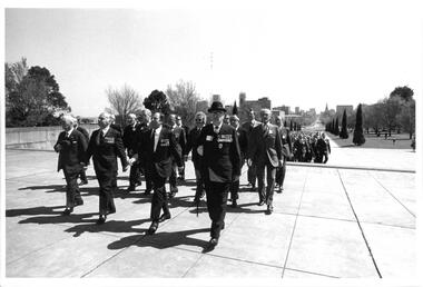
Photograph, Legacy 50th Anniversary Event at the Shrine, 1973
Photos of a ceremony and wreath laying at the Shrine of Remembrance in Melbourne. It was part of the Golden Jubilee 50 year celebrations in 1973. (see also 00479). It is the same event when an Olive Tree of Peace was planted in the western lawn of the Shrine (see 00441 and 00442). The photos show a group of Legatees marching towards the Shrine behind a military band. The men were being led by Legatee Bob Risson. Photos came from an envelope marked P1 Federal Conference 1973 / 50 Year anniversary.A record of a ceremony to mark the 50th year of Legacy.Black and white photo x 7 of a service at the Shrine for the 50th Anniversary.All stamped "This Photograph is the compliments of the Ministry of Tourism, Government of Victoria. Please acknowledge Michael Cheshire" in grey ink. 00479.3 Label on front says "L/Bob Risson with parade at Shrine". 00479.4 Label on front says "Fall in at Shrine".golden jubilee, conference, wreath laying ceremony -
 Bayside Gallery - Bayside City Council Art & Heritage Collection
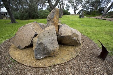
Sculpture, Ellen José, Boon wurrung Blossom, 2008
The bluestone is laid on crushed yellow ochre sandstone, with the base encircled by indigenous flowering plants. Each rock represents one of the six clans that made up the Boon wurrung. For thousands of years, Boon wurrung women and children congregated in this area during special periods in spring and summer. The area was rich in seafood and had fresh water wells dotted around it. Among the Banksia trees that provided shelter, grew indigenous plants and flowers through which the women made garlands to wear in their hair.boon wurrung, blossom, sculpture, public art, indigenous, bayside indigenous coastal trail, ellen josé, ellen jose, bluestone, sandstone -
 Surrey Hills Historical Society Collection
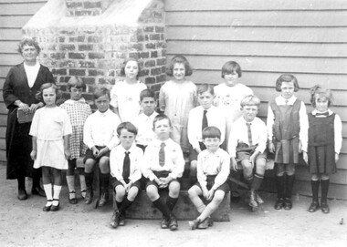
Photograph, Miss Susan Kelsall's school, Canterbury Road, Surrey Hills, 1925
Date is approximate. The teacher is presumed to be Miss Susan Kelsall; 3 of the children are identified as: Back row left: Thora Holmes Back row right: Gwen Evans and Betty Austin. Miss Kelsall was registered as a primary and music teacher in 1908. In 1919 she had a school at Wyclif Church in Norfolk Road. From 1924-1930 the school was in the hall, perhaps built for her, at 426 Canterbury Road, just west of Warrigal Road. This was demolished in 1985; a gum tree marked the spot.Black and white photo of a teacher holding a book and 3 rows of children in front of a weatherboard wall with a brick chimney protruding from the wall. The children are not in uniform although a couple of the girls are wearing tunics and all the boys are wearing ties. independent schools, schools, primary education, music, miss susan kelsall, miss gwen evans, miss betty austin, miss thora holmes, mrs betty harvey -
 Vision Australia
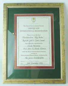
Certificate - Text, Certificate of International Registration for Rhododendron 'Tilly Aston', 31 December 1996
At the top of the page is a shield with a fruit tree inside it and the words 'Founded 1804' and 'Incorporated by Royal Charter 1809'. The certificate reads as follows: The Royal Horticultural Society Certificate of International Registration This is to certify that Rhododendron 'Tilly Aston' 'Apricot Gold' x 'Lem's Cameo' was officially registered by Olinda Nurseries, PO Box 55, Olinda Victoria with the Royal Horticultural Society acting as International Registration Authority for the genus Rhododendron Registrar (signed) Alan C Leslie Date 31st December 19961 cream page with maroon border and gold scrollingassociation for the blind, awards -
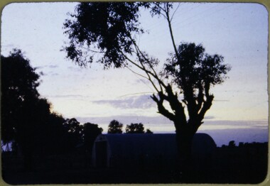 Melbourne Legacy
Slide, Operation Firewood, 1960s
Colour slide of a tree silhouetted against a sunset. It was during Operation Firewood. Legatees would organise collection of wood from the country and distribute it to widows in metropolitan Melbourne. Other slides show the cutting and loading of wood and delivery to widows in metropolitan Melbourne. Was with many other slides taken in the 1950s and 1960s. The slides have been photographed to make digital images and moved to archive quality sleeves. In many cases the original images were not well focussed and the digital image the best available.A record of Legacy helping widows by sourcing, supplying and delivering firewood. When open fires were the main source of heating, a load of firewood and help moving it, would have been very important to the widows.Colour slide of a view of a sunset during Operation Firewood in brown Anscochrome cardboard mount.Printed on front in red ink 'Anscochrome / View from this side / Made in Australia'. Hand written on front 'Firewood' in blue pen. Printed on reverse in red ink 'Processed by Verycolor photo labs. Melbourne, Victoria'.operation firewood, trees -
 Surrey Hills Historical Society Collection
Work on paper - Photograph, Post-war wedding of Norman Pryde and Hilda Scales, 1935
Information from the donor by email gives: Norma Pryde married John Cleak in Camberwell in 1947. Norma's parents were Norman & Hilda Pryde. Norma was born in 1924 in Surrey Hills and attended Surrey Hills State School. Information from the donor's Ancestry.com.au tree: Norma and John had 5 children: 4 boys and one girl. Norma died in 1997 in Murray Bridge, South Australia. John's full name was John Patrick Cleak (1923-2023). This photo documents a post-war wedding when quite often the bride, groom, and wedding party would all simply wear their best suits and dresses.A copy B&W wedding photo of 2 men and 2 women. The men are dressed in suits and wearing buttonholes. The women are wearing hats; the older woman has a corsage on the lapel of her coat and the younger woman is carrying a bouquet.NILnorma pryde, norma cleak, jenny pomeray, 1947, 1940-1949, norman pryde, hilda pryde, hilda gwendoline scales, hilda scales, john cleak, hilda gwendoline pryde, clothing and dress, weddings, john patrick cleak -
 Greensborough Historical Society
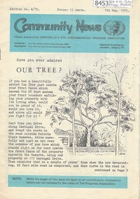
Newsletter, Greenhills and North Greensborough Progress Association, Community News: official journal of the Greenhills and Nth. Greensborough Progress Association. 5th May, 1975. Edition No. 4/75, 05/05/1975
This edition includes a report on the Progress Association's April 1975 meeting, Have you ever admired our trees? Stop press: purchase agreement for a 413 acre park in Diamond Valley [from Mr. and Mrs. Young's combined properties], Diamond Valley Repertory, From the Council Chamber, Letter to the Editor, In memoriam: Gertrude Kerry, Jack Moncrieff, This and that, Kinder news, Meet the natives, Half a horse. Is it better than no horse? A digital copy of this Newsletter is available from Greensborough Historical Society.Newsletter, 23 p., illus.greenhills and north greensborough progress association, greenhills -
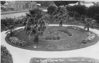
 Stawell Historical Society Inc
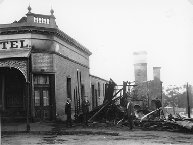
Photograph, Mr Gustav Mahnke’s Bakery Shop on the corner of Main & Wimmera Streets Stawell -- burnt out by fire 1922, 1922
Ruins of Gustav Mahnke’s Bakery Shop Corner of Main Street and Wimmera Street Stawell destroyed by fire 1922. The Chimneys left standing would have belonged to the ovens. Firemen Left R. Chapman - extreme right Alf Pickering , inspecting damage. The Post Office Hotel and the destroyed bakery on the corner of Main and Wimmera Streets. Gustav Mahnke, a German, was a borough Councilor, Mayor for three successive terms - 1904-07. Note extreme right in the backgorundbehind trees - Stawell Baths.B/W. Photograph of the ruins of a burnt building, next to a Hotel with four men.Part of a sign reading "TEL"stawell business streetscape -
 St Kilda Historical Society
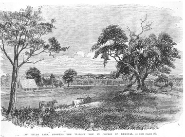
Photograph - Photograph of artwork, St Kilda Park, showing the viaduct now in course of removal, 25/06/1867
St Kilda Park, now Albert Park Reserve, showing cows, eucalyptus trees, oval and a railway viaduct in background. The viaduct was part of the Windsor to St Kilda loop line which operated between 1857 and 1867. The loop line ran from the St Kilda railway station on a combination of wooden viaducts and earth embankments fifteen feet high, crossing over St Kilda and Punt Roads by way of bridges and then gradually decreasing to a level crossing at Union Street and then on to Windsor station. Black and white photograph of a lithograph published in a book (unidentified)ST KILDA PARK, SHOWING THE VIADUCT NOW IN COURSE OF REMOVAL - SEE PAGE 85st kilda railway station, albert park, windsor to st kilda rail loop -
 Stawell Historical Society Inc
Photograph, Central Park Gardens --- 2 Photos 1920's, c1910 - 1920
Central Park Gardens. T R G Williams of Ararat Postcard No36. View from Grandstand with Palms and C.E. General, store in Main Street in Background. Additional later similar photograph with two men near palm tree. John Straton's Wool Skin Store, Commission Agent, in background, later purchased by N. Godfrey who came from Rupanyup but lived in St. George St. Stawell. Photo from Ivan Hodder in 1988. Note Picket fence. Black & white Post card by photographer T.R.G. Williams Ararat of The Palms Central Park Stawell 36. Note Cypress hedge removed with view of general store across Lower Main St. c1910-1920 Second photograph taken from the same position c1920 - 1930 with 2 gentleman in lower left of photograph. John Straton's wool & skin store visible in background.Photograph by T.R.G. Williams Ararat stawell, streetscape -
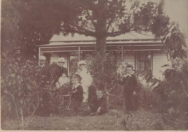 Linton and District Historical Society Inc
Photograph, Todd family in front of their house in Grantley Street, Linton, c.1893
The house in Grantley Street, Linton, is believed to have been the first home of William and Elizabeth Todd and family. The land was held under a miner's right. Original photograph is in an album donated by Stella Surman (nee Todd). Inscription across bottom of original photograph: "Dad / Will / Mum / Aunt Mill / Arthur under tree / Milton standing / Jack on bike / Aunty Mill with Susan / Mum with Charlie". Charlie Todd is a baby in this photograph. His birth year, 1893, was used to date it.Sepia photograph of a family group - three adults, five children and a baby - posed in the front garden outside a cottage. One of the children is seated on a tricycle. The photograph has been mounted on beige-coloured card.todd family, william todd, elizabeth todd, william (billy) todd [william todd jnr], arthur (paddy) todd, milton todd, john (jack) todd, susie todd, charlie todd, millie bennett -
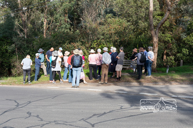 Eltham District Historical Society Inc
Photograph, Peter Pidgeon, Heritage Excursion: Mud Brick Meander, 6 March 2021
Corner of Diamond Street and Peter Street, Eltham. Walkers gather for the beginning of the walk led by local historian Russell Yeoman. The tree-covered hill that forms the western backdrop to the Eltham town centre exhibits many characteristics that are considered to contribute to the special character of Eltham. They include unmade streets, steeply sloping land, extensive tree cover and a large number of mud brick and pise (rammed earth) houses. A number of these were constructed in the 1940s and 50s by well-known builders John Harcourt and Alistair Knox. A significant proportion from this period were constructed by owner-builders. We walked around the upper part of the hill in the area of Kerrie Crescent and Peter Street. We visited several interesting houses (for external viewing only). The walk commenced at 2pm at the corner of Diamond Street and Peter Street (Melway ref 21H4) and was about 2 km. This free walk was open to the general public as well as Society members. Whilst COVID restrictions did not require the wearing of masks in the open, masks had to be carried and all attendees registered with name and contact number or via QR registration.Born Digital (8 images)covid-19, eltham, eltham district historical society, heritage excursion, mudbrick, peter street, diamond street, russell yeoman -
 Eltham District Historical Society Inc
Photograph, Belle Vue, Livingstone Road, Eltham, c.1960, 1960c
Photo taken at time of ownership by Eric Staff. Originally purchased by pioneer Eltham farmer Henry Stooke, Belle Vue farm comprised about 56 ha (140 acres) extending northerly from the northern boundary of Holloway’s 1851 Little Eltham subdivision. On the present day map the southern boundary was just north of Elsa Court and Grove Street. The western boundary was the Diamond Creek and extended northerly to Main Road where it turns easterly towards Research. It was traversed by the main road to Kangaroo Ground and beyond and from 1912 by the railway to Hurstbridge. From 1895 the farm was owned by William Williams and his wife Mary Ann. In 1914-1915 they built a new house now known as “Belle Vue”. They sold the land in 1920 and residential subdivision began soon after that. “Belle Vue” remains today on a large residential lot in Livingstone Road. The house and many old trees on the site have been subject to a heritage overlay under the Nillumbik Planning Scheme. Despite that overlay, most of the heritage trees were removed during sub-division and development of the property.Digital file only from scan of copy on loan to EDHSbelle vue, eltham, eric staff, houses, livingstone road, staff family -
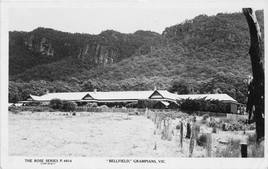 Halls Gap & Grampians Historical Society
Postcard, 03/04/1942
This photograph is the same one printed in 1925 soon after 'Bellfield' became a licenced hotel. Unfinished letter on reverse side indicates that at least 2 postcards were sent to the same recipient Reads as: "Belfield Hotel Grampians 3/4/42 Dear Mother, Well here we are once more amongst the Gum trees and believe me it is great to smell the fresh air once more after so long with the Rubber trees. We are right in the hills with towering mountains on the East and West and after the way the wind blew through gap last night, I would not be at all surprised if that were not the method by which the Gap were made. Several times last night we thought the roof would blow off and now I have cut pegs for the window I hope the rattle does not annoy us anymore. It took us until nearly five to get here last night but of course we did not find the time dragging on our hands. At Ballarat we made a rush for some lunch just got it back to the carriage when the waitress came round for"Photograph shows front of building with Wonderland Range behind handwritten letter on reverse side dated 03/4/42Rose Series P 4914accommodation, hotels, bellfield -
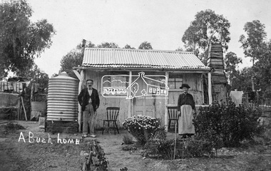 Eltham District Historical Society Inc
Photograph, Tom Prior, A Bush Home - Research, Vic, c.1895
A slab hut situated in Research, Victoria. An elderly man and woman stand in front of their small bark slab home with bark chimney. It has a tin roof and tin water tank to the side. A small garden is situated at the front. Reproduced on pp 38-39 of 'Pioneers & Painters: One Hundred years of Eltham and it's Shire" (1971) Article in "Australian Family Tree Connections" February 2000 by B. J. Parkinson claims that the people in this photo are "Jonas and Christina Jane (Gregg) PRIOR in front of their home at Ferny Hill, near Eltham, Victoria, 1877". Photocopy of photo also attached to 14 online family trees for the Prior family on Ancestry.com without the words "A Bush Home". References found to Prior in historical newspapers and the property "Ferny Hill". Jonas was a convict from Kent, England. He arrived in Hobart in 1821 aged 19 years. He married Christina Gregg in Hobart about 1834 and had 11 children. They came to Victoria about 1846. He died at Ferny Hill, near Research, Eltham in 1878 aged 74 years and was buried at Melbourne General Cemetery. His occupation was gardener.This photo forms part of a collection of photographs gathered by the Shire of Eltham for their centenary project book,"Pioneers and Painters: 100 years of the Shire of Eltham" by Alan Marshall (1971). The collection of over 500 images is held in partnership between Eltham District Historical Society and Yarra Plenty Regional Library (Eltham Library) and is now formally known as the 'The Shire of Eltham Pioneers Photograph Collection.' It is significant in being the first community sourced collection representing the places and people of the Shire's first one hundred years.Digital image 4 x 5 inch B&W Neg Print 20 x 25 cmshire of eltham pioneers photograph collection, research (vic.), ferny hill, jonas prior, christina prior, hut, prior, convict, pioneers and painters -
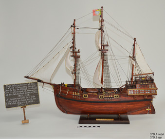 Flagstaff Hill Maritime Museum and Village
Craft - Ship Model, Portuguese Carvel, 1999
The Mahogany Ship is today regarded as a legend and refers to an ancient wreck that is purported to lie beneath the sand beside Armstrong Bay, several kilometres west of Warrnambool, Its location is currently unknown. For well over a century the mystery of this ship has fascinated Australians because the existence of such a vessel could throw a different light on the earliest phases of exploration of eastern Australia by Europeans. The story is that in January 1836 a party of whalers from Port Fairy travelled to the mouth of the Hopkins River in search of seals. Their boat overturned and one man was drowned. The three survivors were walking the 30 kilometres back to Port Fairy along the coast when, about halfway along, they discovered the wrecked ship in the dunes. It is said that Captain John Mills, who was in charge of the whaling station at Port Fairy promptly visited the wreck with several of his men, including Hugh Donnelly. Donnelly who was the originator of that version of events is now regarded as unreliable. Local history researcher Joan Fawcett believes Donnelly could not have visited the wreck in 1836 because he did not arrive in Victoria until 1841. The "mahogany" description can be traced to a letter from Port Fairy builder, architect and surveyor John Mason and published in the Melbourne Argus in 1876. He said he had seen the hull in 1846 and it "had the appearance of either cedar or mahogany." In 1884 Argus journalist `The Vagabond' wrote that the hull was built of "Spanish mahogany" and six years later Mason wrote another letter saying it might not have been mahogany but red gum or ironbark from New South Wales. He was too late with this new description as the wrecks mahogany tag was here to stay all through the hull was not visible as it had disappeared beneath the shifting sands by 1880. A more reliable account was later presented by the former editor of the Warrnambool Examiner, historian Richard Osburne, who wrote about the wreck in his book History of Warrnambool (published 1887). In it the author remembers to have noticed a wreck in the hummocks between Belfast and Warrnambool, in 1847 or 1848; he stated it was much nearer Warrnambool than Belfast, now known as Port Fairy, going on to state “in fact, it was only two or three miles from the former place, to the west of the big hummock which was supposed to fill Warrnambool Bay with drift sand washed by the Merri River before the cutting was made.” Osburne followed up with a letter to the Port Fairy Gazette on June 25, 1876, during a period of heightened interest in the wreck, although he was unsure of the provenance of the ship he went on to state in his letter. “The old wreck was, in fact, miles away from the Port Fairy beach, and only about four miles from Warrnambool. In the years 1847 and 1848. I have often seen the wreck and I regret to say I do not believe she was a foreign ship at all.”The ship model is significant for its association with the Warrnambool story of what is now referred to as the Mahogany Ship, an ancient shipwreck. The model is significant as it is an interpretation of a Portuguese caravel and possibly associated with the early history and exploration of Southern Australia. The model is a fine example of a hand crafted ship made from plans, not from a kit. Some of the materials used for the model are significant to the Gembrook community in that the timber used is a portion from a 30-meter pine tree that fell onto and destroyed the 120-year-old Gembrook church building. The model is also a dedication to Edward Kermond, who grew up in Warrnambool and claimed to have seen the shipwreck in the dunes when he was a lad in the late 19th century. (See note section of this document for further information on the creator and donation of the subject item).Ship model, an interpretation of a mahogany Portuguese carvel vessel in a glass display case with wood frame and a description plaque. Model is made from dark stained wood. The three masted vessel is fully rigged, with a Portuguese-like flag on mast. Plaque is rectangular, free standing on a pedestal. The model was handmade by Joe Hilder (Senior) in 1999 from flooring obtained from the Gembrook Uniting Church in Victoria. Inscriptions, hand written, under base of case and on plaque.Under base, black felt tip pen “Ship & Case made From / Flooring from Gembrook uniting Church, Flattened in 1999 / By Large Pine Tree.” On plaque, white paint "This interpretation of the Fabled Mahogany Ship was made by Joe Hilder, Gembrook Vic. is displayed in the memory of the late Edward Kermond (Ted) 1887-1973, a Warrnambool son who claimed to have seen the original ship as a child." flagstaff hill, warrnambool, flagstaff hill maritime museum, shipwreck coast, flagstaff hill maritime village, great ocean road, ship model, mahogany ship, mahogany ship story, portuguese caravel, joe hilder, edward kermond, ted kermond, gembrook uniting church, gembrook storm 1999, port fairy whalers, belfast whalers -
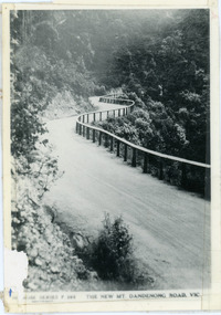 Mt Dandenong & District Historical Society Inc.
Photograph, The New Mt Dandenong Road, Vic
Copy of Rose Series postcard #385 showing the new Mt Dandenong Tourist Road with wooden railing fence on low side of road. Surface not yet made. This photograph has a detailed inscription on the back handwritten by John Lundy-Clarke in 1974.View downhill from the Windy Bend showing the site of the 1972 landslide. In this picture the road is running along the top edge of the wall 900’ thick of Kalorama Docite that plunges thousands of feet deep down into the earth below the Ranges and extends to Fern Tree Gully. It was once a horizontal terrace nearly ten miles square and tipped over to the left when the mountain subsided into its volcanic cauldron.mt dandenong road, rose series, windy bend, landslide -
![The Bend of the Yarra at Studley Park / [by] Nicholas Caire, circa 1876](/media/collectors/550653872162f11fb04854aa/items/5783120ed0cdd1176c47d8c8/item-media/57831278d0cdd1176c4805d6/item-fit-380x285.jpg) Kew Historical Society Inc
Kew Historical Society IncPhotograph, Anglo-Australasian Photographic Company, The Bend of the Yarra at Studley Park, c. 1876
Nicholas Caire was born on Guernsey in the Channel Islands in 1837. He arrived in Adelaide with his parents in about 1860. In 1867, following photographic journeys in Gippsland, he opened a studio in Adelaide. From 1870 to 1876 he lived and worked in Talbot in Central Victoria. In 1876 he purchased T. F. Chuck's studios in the Royal Arcade Melbourne. In 1885, following the introduction of dry plate photography, he began a series of landscape series, which were commercially successful. As a photographer, he travelled extensively through Victoria, photographing places few of his contemporaries had previously seen. He died in 1918. Reference: Jack Cato, 'Caire, Nicholas John (1837–1918)', Australian Dictionary of Biography.An original, rare photograph from the series 'Views of Victoria: General Series' by the photographer, Nicholas Caire (1837-1918). The series of 60 photographs that comprise the series was issued c. 1876 and reinforced a neo-Romantic view of the Australian landscape to which a growing nationalist movement would respond. Nicholas Caire was active as a photographer in Australia from 1858 until his death in 1918. His vision of the Australian bush and pioneer life had a counterpart in the works of Henry Lawson and other nationalist poets, authors and painters.‘The Bend of the Yarra at Studley Park’ : Views of Victoria (General Series) No.49 : Albumen silver photograph | Photo on card with Title and Description on reverse | Mounted 24 x 30 cm; Photo 12 x 17 cm.On Reverse: The subject of the present illustration is taken from near the Kew Road, on the Park-hill side of the Yarra. The curve of the River at this and other parts of the Park represents a gigantic letter S. It is a remarkable fact that the hilly side of the River is covered with a mass of foliage of various descriptions, from the stately gum tree to the stunted wattle, whilst the opposite side of flat country has scarcely a shrub to be seen any where.’nicholas caire (1837-1918), studley park, yarra river, kew, landscape photography - victoria -
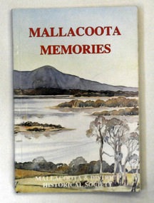 Orbost & District Historical Society
book, Mallacoota Memories, 1980
This book was produced by the Mallacoota and District Historical Society. The Society, founded in 1974, has a museum housed in a World War 2 Bunker in Mallacoota . The bunker was handed over to the Society by the R.S.L.A small 104 pp book titled Mallacoota Memories. On the front cover is a coloured photo of lakes and trees. The title is in red. The book contains early observations by J.[G] A. Robinson; contact with settlers; mentions Biduelli, Kruatungulung, Murring, Ben- Kurnai, Mallekotang Mittong, Tinnon, Kyrekong, Ponedyang, Worarer Mittong groups. The history is from 1841 -1945. It was produced by Mallacoota and District Historical Society.mallacoota-history robinson-j.a -
 Flagstaff Hill Maritime Museum and Village
Photograph - Portrait, Arthur & Son, photographers, Miss Carmichael, 1878
Miss Eva Carmichael, the subject of the photograph, was one of only two survivors from the wreck of the Loch Ard, wrecked on Mutton Bird Island near Port Campbell, Victoria, on June 1st, 1878..The photograph holds great significance for its connection to Eva Carmichael, one of two survivors from the wreck of the Loch Ard. It is also significant for its connection to the Loch Ard, one of the most tragic shipwrecks in Victoria's coastline and listed on the Historic Shipwreck Register.Photographic portrait mounted on brown cardboard of Miss Eva Carmichael. Miss Carmichael is standing near an upholstered chair and rests wth both hands upon a masonry pillar. Behind her is a balustrade in the classic style common to that period. The background consists of a large tree giving the impression of a garden setting. It was produced at the studio of Arthur & Son, Mount Gambier, 1878. Inscriptions handwritten below the photograph. Handwritten in white "Miss Carmichael" Stamped "Arthur & Son / MOUNT GAMBIER"flagstaff hill, warrnambool, shipwrecked-coast, flagstaff-hill, flagstaff-hill-maritime-museum, maritime-museum, shipwreck-coast, flagstaff-hill-maritime-village, photograph, shipwreck loch ard, eva carmichael, portrait, arthur & son, mount gambier, loch ard, shipwreck, mutton bird island -
 Bendigo Military Museum
Photograph - PHOTOGRAPHS WW1, C.1918
.1) On rear: 10 days furlough to England. I left the trenches on the 22nd Dec and arrived in England on the 27th and left again on the 6th Jan for the Somme. I had a Bon Time. This fits in with James Archibald TODD No 2418 AIF. By his records this was 1917 - 1918 leave. Refer Cat No 1340P for his service details. .2) On rear: France 2.6.18. Kindest Regards to all from Jim. .3) On rear: Le Mart France, Dear -- this is some of my mates, I am on this -- with love to all, Jim. The 3 photos all relate to James Archibald TODD No 2418 AIF. Refer Reg No 1217 for his brother Charles, KIA. .1) Photo postcard, sepia, showing 4 soldiers, 2 sitting & 2 standing. Handwriting on rear in purple pencil. .2) Photo postcard, sepia, showing a group of 17 soldiers dressed for entertainment. Handwriting on rear in blue ink. .3) Photo, sepia, showing a large group of uniformed men with trees in the background. 3 dogs are in the front row. Handwriting on rear in black pen..2) Printed in white underneath the photo: “ANZAC COVES - PIERROT TROUPE DIRECT FROM THE FIRING LINE”photographs, france, todd -
 Streatham and District Historical Society
Post Card, 1914-1918
Paper card with a picture of a house with a thatched roof. There is a stone wall and two trees that are beginning to blossom. There are four children two boys and two girls. One girl has no footwear. One boy is holding a goat. There are two goats a large pig and chicken in the picture. The words" An Irish Cabin" appears on the lower left side and a Orange ribbon has been attatched to the lower right side."Dear Bess I suppose you think I an never going to answer your pursuit but I thought I would do so while here in Belfast cause I know you have a lot of time for the Micks. How would you like a little home like this one no cows to milk only goats no horses to drive only donkies & it looks as though the girls have no boots to clean by this card but there is some first class sig hias this one has taken a purge he must be an Ulsty show. Love from Donald -
 Glen Eira Historical Society
Photograph, Gloucester Court, 6, Murrumbeena, 2001
Originally labelled "Beauville Estate, Established 1936, Still Thriving 65 years on, 10th March 2001", the Beauville Estate Album contains colour photographs of houses in the Estate. They were taken around the time of the Beauville Estate’s 65th Heritage Celebration held on 10/03/2001 and donated to the Caulfield Historical Society shortly afterwards. Photographer unknown. City of Glen Eira’s Heritage Management Plan Vol 2 p79 (this is p84 of the pdf version) – HO12 Beauville Estate and environs, Murrumbeena: The Beauville Historic Area is important at the State level as the first large housing estate undertaken by the AV Jennings Construction Co, later Jennings Group Limited, Victoria’s largest home builder. It is important also as a very early estate development incorporating a range of features other than houses and including made roads, shops and recreation facilities. In this respect it was the forerunner of the comprehensively planned housing estate of the post war era. The estate is distinguished by its aesthetic values, as is the earlier and comparable Hillcrest Estate, which are formed by a combination of restrained diversity in house styles, with the exception of no. 30 in the emerging International style, and by a landscaped garden environment. Colour photograph of a fence with four rows of unpainted variegated brown bricks at the bottom and six cream rendered columns topped by two rows of the same unpainted bricks. Timber pickets painted in the same colour complete the fence between the columns. The pitched roof of the rendered house can be seen in the background and the gable has a simple aeroplane-like decoration. Tall trees are behind and in the foreground. murrumbeena, houses, architectural styles, 1930's, inter war style, a.v. jennings, av jennings, jennings, brick houses, beauville estate, gloucester court, sir albert victor jennings, a v jennings construction co, beauville estate heritage area, glen eira city council, architectural features, jennings group limited, land subdivision, gardens, beauville historic area, rendered houses, timber and brick fences -
 Federation University Historical Collection
Postcard - photographic, Nouza Gardens, Egypt, c1916
The photograph is associated with Harry Holmes who was a member of the Australian Imperial Force based in Egypt at the time. Egypt was a major base for the AIF from December 1914. A number of campaigns were fought in this theatre. There were two campaigns involving the AIF. Note that not all the fighting was actually geographically in Egypt. (http://www.aif.adfa.edu.au:8888/about3.html) Four postcards of Nouza Gardens, alexandria, Eygpt. .1) Two English soldiers walk down a tree lined avenue at Nouza gardens .2) Garden setting with fernery building on the right. .3) Gardens with towered building in the centre of the photograph .4) Three Egyptian boys who acted as guide to Australian Soldiers Harry Holmes and his friends sit on a seat in front of a fernery building. .1) Aveue at entrance to Nouza gardens, Two tommies in the foreground. .2) View at gardens. Nouza .3) View taken at Nouza Gardens, Alexandria. .4) The fernery at Nouza Gardens. Very pretty inside. the three boys we picked up and they acted as our guides. chatham family archive, chatham, holmes, world war, world war 1, world war i, world war one, harry holmes, nouza gardens, alexandria, egypt -
 Yarra Glen & District Historical Society
Sepia postcards, Yarra Glen
Sepia postcard with a view taken from the Grand Hotel tower looking down on Bell Street and the railway crossing at Yarra Glen very late 19th century. Young street trees on Bell Street. On east side of Bell Street are a dwelling, a general store, the Victoria Hall, a horse trough. Beyond the railway line is 'River View', the bridge over the river and the Yering flats.On back of postcard at the top "POST CARD". On the left hand side "THIS SPACE MAY BE USED FOR PRINTED OR WRITTEN MATTER”. On the right hand side "ONLY THE ADDRESS TO BE WRITTEN HERE”. In a box in the right hand corner "A HALF-PENNY STAMP TO BE PLACED HERE". Along the left hand margin "Ajax series. Printed in England". In blue biro is written "G. Keets Yarra Glen". Copy 2 has the following handwritten in black ink: "Yarra Glen. 28.8.11. Dear Maggie Hope you will like the Postcard. I also hope your head is better. On Saturday we took the kitten down to Dawborn's shop to catch some mice. When we got down there the kitten got away from us and we never got it till Monday morning. This is all the news this time. From your loving cousin, Walter.yarra glen, railway line, grand hotel, victoria hall, bell street, tree guards, railway crossing, river view, street trees, bell st, general store, horse trough -
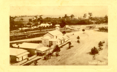
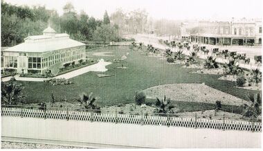 Bendigo Historical Society Inc.
Photograph - BLACK AND WHITE PHOTOGRAPH OF THE CONSERVATORY GARDENS AND SURROUNDING AREA
Black and white photograph of the conservatory gardens and surrounding area. The phot shows the early plantings of the palm trees along the outer fence, and the layout of garden beds waiting to be filled with plants.Just left of centre is a white statue. At the start of Bridge street on the right side there is a line cabs waiting for business. Centre can be seen the bridge over the Bendigo Creek. To the right centre there are a group of retail establishments.bendigo, parks and gardens, conservatory gardens -
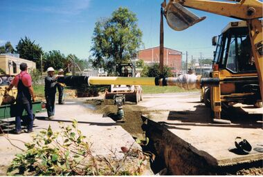 Bendigo Historical Society Inc.
Photograph - CASTLEMAINE GAS COMPANY COLLECTION: PHOTO EXCAVATION
Pipe being laid in trench, 3 workers handling the pipe another one on a bobcat and one on an excavator, man in red shirt standing next to a generator on a trailer, Centre is a hand activated compactor, behind which is the bobcat, left background is cream coloured building, Tree at rear of bobcat, Red brick building to right of centre, right front corner is welding eye shield on the ground.Kodakorganisation, industry, gas and fuel -
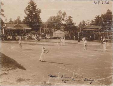 Bendigo Historical Society Inc.
Photograph - TENNIS COURTS, UPPER RESERVE, BENDIGO
Sepia photograph of tennis players. Pavilion with backdrop of mature trees, small marquee. Males in long pants, female in long dress. Spectators seated around courts. On front written in black ink 'tennis courts, upper reserve, Bendigo' MP128 at TR corner. Asphalt tennis course situated immediately behind where the Bendigo Croquet Club is now located, Rosalind Park.place, sport, tennis courts, upper reserve, ben -
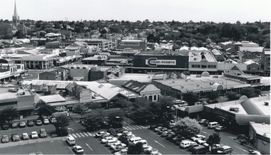 Bendigo Historical Society Inc.
Photograph - AERIAL VIEW OF BENDIGO, 1995
Black and white photo: view of Bendigo with Mitchell St. from centre left to centre. Shows Sacred Heart Cathedral at left. Coles supermarket carpark in foreground. Dome of RSL in Pall Mall in front of trees to right. On back C 26A. Noelene Wild July 2000 ' photo by Peter Hyett 1995 from St. Paul's Myer St., Sacred Heart Cathedral at left.'Peter Hyettplace, aerial view of bendigo -
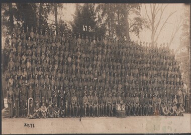 Bendigo Historical Society Inc.
Photograph - 67TH BATTALION, c1917
Sepia photo. 67th Battalion, large number of men, in the front 2 rows have music instruments. Markings/Inscriptions: 67 Batt is written on the trees centre rear. X1572 bottom of photo on the left. Bottom right corner of board: Phone 4397. 'Darge'1,5 Collins St, Melbourne. On rear in hand writing is Broadmeadows February 1917. Golden Square 31 Aug '22.Darge, Collins St, Melbourneorganization, military, 67 batallion, darge, collins street, melbourne. ph 4397