Showing 2217 items
matching railway line
-
 Surrey Hills Historical Society Collection
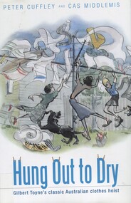
Book, Hung out to dry: Gilbert Toyne's classic Australian clothes hoist, 2009
... was in Mont Albert Road near the railway line and the family lived.... The factory was in Mont Albert Road near the railway line ...Archibald McKirdy purchased the Toyne's hoist business in 1925 and moved its production from Carnegie to Mont Albert where the family had lived since the 1880s. The factory was in Mont Albert Road near the railway line and the family lived at 2 Stanhope Street. 'Hung Out to Dry' is based on detailed and innovative research and analysis; part family history, part social history, part industrial history, part garden history. It is the story of the rotary clothes hoist.'Hung Out to Dry' is based on detailed and innovative research research and analysis; part family history, part social history, part industrial history, part garden history. It is the story of the rotary clothes hoist.(mr) gilbert toyne, inventors, (mr) archibald mckirdy, clothes lines, (mr) peter cuffley, cas middlemis -
 Eltham District Historical Society Inc
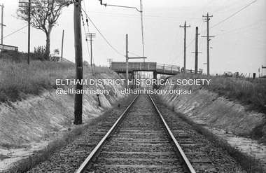
Photograph, Railway overpass on Sherbourne Road at junction of Para Road and Simms Road, Briar Hill, 3 November, 1967
... Viewed from railway line opposite Graham Body Works. Simms...Viewed from railway line opposite Graham Body Works. Simms ...Viewed from railway line opposite Graham Body Works. Simms Road is running to the right in front of the old house. The house belongs to Mrs Cameron whose daughter married a DAVEY after which Davey Street is named. Excavation work is being undertaken for the realignment of the Para Road and Sherbourne Road intersection where the current roundabout is located, approximately where the two cars are parked. Mrs Cameron's house and the other are where Montmorency Secondary College is situated. The school opened in 1969.Roll of 35mm black and white negative film, 6 strips Ilford HP3briar hill, cameron, davey, davey road, graham body works, greensborough, montmorency secondary college, sherbourne road, simms road -
 City of Kingston
Photograph - Colour, c. 1993
... , Kananook Creek and Nepean Highway. The railway line can be seen... Reserve, Kananook Creek and Nepean Highway. The railway line can ...Patterson Lakes is a suburb in the City of Kingston that is built one kilometre upstream of the mouth of the Patterson River. The area is bordered by the Patterson River and Eel Race Drain which enters the Kananook Creek. The suburb consists predominantly of newer housing developments and the tidal canal system of the development joins Port Phillip Bay.Patterson Lakes and the Kananook Creek were previously part of the extensive Carrum Carrum Swamp. The area was once a source of fish and eels for the Mayone-Bulluk clan of the Bunurong people. Over time the area was drained and in 1973 investigations commenced into the development of a unique residential area that would be built adjacent to canals and waterways. It was originally proposed to be known as "Gladesville". The development would give the suburb's homeowners access to Port Phillip Bay "from their back door". Circa 1974, the area was rezoned from rural to residential and named Patterson Lakes. Development has been continuous since the 1970s with construction of residential housing, schools, shopping centres, marinas, a hotel and library.Laminated colour aerial photograph of the Carrum and Patterson Lakes region within City of Kingston. This 1993 image includes Patterson River Secondary College, Roy Dore Reserve, Kananook Creek and Nepean Highway. The railway line can be seen as it veers inland from Eel Race Road, Seaford. The section of Palm Beach Drive, Curlew Point Drive, Snapper Point Drive, Clipper Island and Myola Street in Patterson Lakes appears to be a recent development with many spare blocks and new houses under construction.patterson lakes, seaford, kananook creek, carrum carrum swamp, canals and waterways -
City of Kingston
Photograph - Black and white, 17 January 1951
... . Nepean Highway and the Frankston railway line run centrally... Club are visible. Nepean Highway and the Frankston railway line ...Moorabbin, Cheltenham and Highett are suburbs in the City of Kingston with a diverse mix of development and zoning. This 1954 image shows the market gardens, farms and paddocks of the Moorabbin and Cheltenham area. which have gradually been sub-divided into The Highett Gas Works is visible and Cheltenham Park and Victoria Golf Club.The suburbs of Cheltenham and Moorabbin were originally developed with extensive market gardens. Over time the district has been transformed with the farms and paddocks replaced by housing, factories and shopping centres. The Highett Gas Works on the Nepean Highway was a significant feature of the landscape and has now been demolished. and the site has undergone remediation.Aerial photograph of Cheltenham, Moorabbin and Highett within the City of Kingston. The area depicted in this 1951 aerial view includes Wickham Road, Highett (bottom right), Keys Road, Moorabbin (bottom left), Centre Dandenong Road Cheltenham (top left), Park Road, Cheltenham (top right), Nepean Highway (left section), Graham Road and Middleton Street, Highett (bottom right). Cheltenham Park and Victoria Golf Club are visible. Nepean Highway and the Frankston railway line run centrally through the image.White type: 1416-37 538 RUN239 LENS 5312" MELBOURNE METROPOLITAN 12150 17-1-51 ↆ M539 Black pencil: N [arrow]cheltenham, highett, highett gas works, market gardens -
 Orbost & District Historical Society
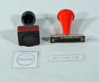
stamps, c. 1916-1987
... Used by Victorian Railways at the Orbost Railway Station... with the history of the Orbost-Bairnsdale railway line and therefore ...Used by Victorian Railways at the Orbost Railway Station. The line to Orbost closed in 1987.This item is associated with the history of the Orbost-Bairnsdale railway line and therefore reflects the role that the rail line played in the social and economic history of Orbost.Two stamps, one with a black handle, one with red handle. One is square and has the word CANCELLED within a circle. The other is rectangular in shape and has the words ORBOST FREIGHT DEPOT. CANCELLED ORBOST FREIGHT DEPOTrailway-history orbost-railway -
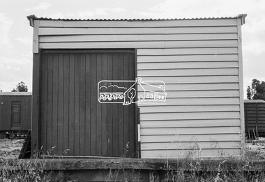
 Eltham District Historical Society Inc
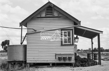
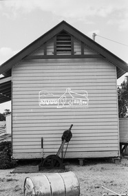
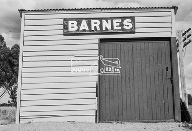
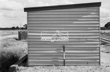
Photograph, Barnes Railway Station, Moama, NSW, c.November 1962, 1962
... . Deniliquin railway line https://en.wikipedia.org/wiki.... Deniliquin railway line https://en.wikipedia.org/wiki ...The railway reached Echuca in 1864 and transformed the town into a major river port, with a famous wharf and substantial urban growth in the 1870s. In 1876 the Deniliquin and Moama Railway Company opened its 71 km (44 mi) private railway northwards to Barnes and Deniliquin, and the line at Echuca was extended across the Murray River into Moama to join the railway. This section was taken over by Victorian Railways in 1923, as part of the 1922 Border Railways Act. Barnes station was closed in 1979. Deniliquin railway line https://en.wikipedia.org/wiki/Deniliquin_railway_lineDigital TIFF file Scan of 35mm Ilford FP3 black and white negative transparencybarnes railway station, echuca, george coop collection, moama -
 Eltham District Historical Society Inc
Photograph, Barnes Railway Station, Moama, NSW, c.November 1962, 1962
... . Deniliquin railway line https://en.wikipedia.org/wiki.... Deniliquin railway line https://en.wikipedia.org/wiki ...The railway reached Echuca in 1864 and transformed the town into a major river port, with a famous wharf and substantial urban growth in the 1870s. In 1876 the Deniliquin and Moama Railway Company opened its 71 km (44 mi) private railway northwards to Barnes and Deniliquin, and the line at Echuca was extended across the Murray River into Moama to join the railway. This section was taken over by Victorian Railways in 1923, as part of the 1922 Border Railways Act. Barnes station was closed in 1979. Deniliquin railway line https://en.wikipedia.org/wiki/Deniliquin_railway_lineDigital TIFF file Scan of 35mm Ilford FP3 black and white negative transparencybarnes railway station, echuca, george coop collection, moama -
 Federation University Historical Collection
Book, Railway Practice: a collection of working plans and practical details of construction in the public works of the most celebrated engineers, 1847 (exact)
... of the London to Birmingham railway line. He published two technical... to Birmingham railway line. He published two technical books called ...A green cloth hard cover book. Title and author's name are engraved in gold on spine. This is the 3rd edition, first series with black and white illustrations. It describes the engineering practices of the early days of British railroads. The book includes (series 1 to 4)and it contains, roads, tramroads and railroads, bridges, aqueducts, viaducts, wharfs, warehouses, roofs, and sheds, canals, locks, sluices, & the various works on rivers, streams, etc., harbours, docks, piers and jetties, tunnels, cuttings and embankments, the several works connected with the drainage of marshes, marine sands, and the irrigation of land, water-works, gas-works, water-wheels, mills, engines.civil engineering, railway practice, rail constructions, s c brees, western railway great britain, public works, railroads, canals, s.c. brees, samuel brees, samuel charles brees -
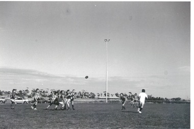 Sunbury Family History and Heritage Society Inc.
Photograph, Clarke Oval
... and Shields Streets. Later land adjacent to the railway line, now... Streets. Later land adjacent to the railway line, now Sunbury ...The Sunbury Football Club, known as 'The Swifts' was formed in 1897 and the early matches were probably played on Munro's which was a stretch of land bounded by Evans, Barkly, O'Shanassy and Shields Streets. Later land adjacent to the railway line, now Sunbury Shopping Centre was where football was played until Clark Oval was opened in 1953. Since then it has been the town's main sporting venue and the site for the annual show and other events. In this photograph the football match is being played on the Clark Oval with the clubrooms visible in the background. The Sunbury Football Club is one of a number of sports clubs established vin Sunbury.A non-digital black and white photograph of a football match being played on an oval. The clubrooms are visible in the distance.sunbury football club, clark oval, "the swifts' -
 Wodonga & District Historical Society Inc
Award - Darts Trophy - A.W.D.D.A Winter '93 - A-Grade
... in Wodonga, with clear links to the establishment of the railway line..., with clear links to the establishment of the railway line ...The Terminus Hotel was one of the earliest hotels in Wodonga, with clear links to the establishment of the railway line. It was an important business and meeting place from the original construction in 1873 until 1st June 1998 the Terminus Hotel when it was destroyed by fire. It provided a popular venue for social activities, including competitive darts, both through its own competition and as part of the Albury-Wodonga District Darts Association. The remains of the building were demolished in 1999. This is a trophy for the Albury-Wodonga District Darts Association won by the team "Terminus Goers' in 1993.The Terminus Hotel was an important meeting place in Wodonga for more than 100 years. This item is representative of one of the social and sporting activities it provided for members of the local community.A trophy made from timber and metal with a representation of a dart on the top.On plaque lower front "A.W.D.D.A WINTER '93/A GRADE PREMIERS TERMINUS GOERS" In vertical list "B. TINGWELL (C) S. GRIFFITHS J. DE KRUIFF A. GARDNER R. GARDNER L. SIMS W. KILPATRICK B. SNEDDONterminus hotel, terminus hotel darts, sport and recreation wodonga -
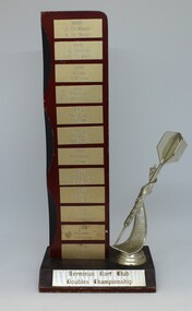 Wodonga & District Historical Society Inc
Award - Darts Trophy - Terminus Dart Club Doubles Championship, 1985
... in Wodonga, with clear links to the establishment of the railway line..., with clear links to the establishment of the railway line ...The Terminus Hotel was one of the earliest hotels in Wodonga, with clear links to the establishment of the railway line. It was an important business and meeting place from the original construction in 1873 until 1st June 1998 the Terminus Hotel when it was destroyed by fire. It provided a popular venue for social activities, including competitive darts, both through its own competition and as part of the Albury-Wodonga District Darts Association. The remains of the building were demolished in 1999. This is a perpetual trophy for the Terminus Dart Club Doubles Championship from 1985 to 1992.The Terminus Hotel was an important meeting place in Wodonga for more than 100 years. This item is representative of one of the social and sporting activities it provided for members of the local community.A wood and metal engraved trophy with stylised dart mounted on the side.At base: " TERMINUS DART CLUB/ DOUBLES CHAMPIONSHIP" On vertical list - top to bottom 1985 J. DEKRUIFF/ H. DEKRUIFF 1985 R. HUDSON/ A. FLEMING 1986 K. COOK/ H.M. COOK 1986 TONY LOWE / K.A.COOK 1987 J. DEKRUIFF/ A. FLEMING 1987 L. STOKES / K. MERRILESS 1988 J. DEKRUIFF/ T. LOWE 1989 ROB BENNETT/ B. STEWART 1989 L. BRUCE/B. STEWART 1991 J. DEKRUIFF/ P. HOLLINGSWORTH 1992 B. TINGWELL/ S. GRIFFITHS 1992 B. TINGWELL / C. BLUNDEN terminus hotel darts, terminus hotel wodonga, sport and recreation -
Whitehorse Historical Society Inc.
Article, Historic steam trip, 2/11/1982 12:00:00 AM
... of the Camberwell - Lilydale railway line. The K190 steam local will stop... was the case for 20 years. Railways Camberwell to Lilydale Rail Line ...Commemorative one day steam trip to celebrate the centenary of the Camberwell - Lilydale railway line.Commemorative one day steam trip to celebrate the centenary of the Camberwell - Lilydale railway line. The K190 steam local will stop at Blackburn for a short ceremony. The celebration on 27 November will be organized by the Australian Railway Historical Society. Archivist Keith Paterson said when the line opened December 1882 the area east of Box Hill had only small and scattered pioneer farms, no shops and only one post office at a hotel in Blackburn and 1 or 2 schools. In 1861 first station was opened, terminating at Hawthorn, which was the case for 20 years.Commemorative one day steam trip to celebrate the centenary of the Camberwell - Lilydale railway line. railways, camberwell to lilydale rail line centenary, australian railway historical society, patterson, keith arthur -
 Kew Historical Society Inc
Plan - Subdivision Plan, Harvest Home Estate, 1919
... Railway line [at the end of Owen Street]. Understandably... 11 residential allotments abutting the Outer Circle Railway ...Pru Sanderson, in her groundbreaking ‘City of Kew Urban Conservation Study : Volume 2 - Development History’ (1988), summarised the periods of urban development and subdivisions of land in Kew. The periods that she identified included 1845-1880, 1880-1893, 1893-1921, 1921-1933, 1933-1943, and Post-War Development. These periods were selected as they represented periods of rapid growth or decline in urban development. An obvious starting point for Sanderson’s groupings involved population growth and the associated economic cycles. These cycles also highlighted urban expansion onto land that was predominantly rural, although in other cases it represented the decline and breakup of large estates. A number of the plans in the Kew Historical Society’s collection can also be found in other collections, such as those of the State Library of Victoria and the Boroondara Library Service. A number are however unique to the collection.The Kew Historical Society collection includes almost 100 subdivision plans pertaining to suburbs of the City of Melbourne. Most of these are of Kew, Kew East or Studley Park, although a smaller number are plans of Camberwell, Deepdene, Balwyn and Hawthorn. It is believed that the majority of the plans were gifted to the Society by persons connected with the real estate firm - J. R. Mathers and McMillan, 136 Cotham Road, Kew. The Plans in the collection are rarely in pristine form, being working plans on which the agent would write notes and record lots sold and the prices of these. The subdivision plans are historically significant examples of the growth of urban Melbourne from the beginning of the 20th Century up until the 1980s. A number of the plans are double-sided and often include a photograph on the reverse. A number of the latter are by noted photographers such as J.E. Barnes.The ‘Harvest Home Estate’ was advertised as being a subdivision in East Kew. Now, Campbell and Owen Streets on which the allotments were located are classed as being in Kew. The Estate included 11 residential allotments abutting the Outer Circle Railway line [at the end of Owen Street]. Understandably, the vendors focused on the availability of transport by tram, noting that the Estate was near the High Street tram terminus at the Harp of Erin. A small note on the subdivision advises that the Cotham Road tram was only 3 minutes away. The location – ‘The most elevated position in lovely Kew’ – was also promoted as an advantage.subdivision plans - east kew, harvest home estate -
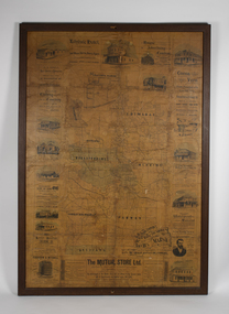 Bacchus Marsh & District Historical Society
Map, The Unique Advertising Combine, The Unique Combine's New Map of the Shire of Bacchus Marsh, 1890
... and the railway line are also shown on the map. Around the edges... and the railway line are also shown on the map. Around the edges ...This map was one of a number of similar maps produced for advertising purposes by a company called, 'The Unique Advertising Combine'. The company was located in Melbourne on Queens Walk. A brief item in the Bacchus Marsh Express newspaper on 29 March 1890 , page 2, indicated that subscribers to the Bacchus Marsh Express could obtain a copy of this map in the next issue of that newspaper. On the map is the detail that it was compiled by W.H. Bonney from official records supplied by D. A. Little, hire Secretary, (of Bacchus Marsh Shire).This map with its accompanying illustrations of local businesses and shops in Bacchus Marsh is an important documentary and visual snapshot of the town and district of Bacchus Marsh in the later part of the nineteenth century. The illustrations for some of the local businesses are the only known visual record of those particular buildings. The map is a rare surviving example of the material produced by The Unique Advertising Combine. Another similar example for the Shire of Mornington is held by the State Library of Victoria,A map of the Shire of Bacchus Marsh produced in March 1890. The map is mounted on a board and enclosed within a timber frame. The map includes an inset detail section showing the central part of the township of Bacchus Marsh including the main shopping and business streets. Land holdings with the first European land holders names indicated are included on the map. Rivers, creeks, major roads and the railway line are also shown on the map. Around the edges of the map are illustrated advertisements mostly for Bacchus Marsh businesses but which also includes some businesses located in Melbourne. maps bacchus marsh shire, shops bacchus marsh -
City of Kingston
Photograph - Black and white, 3 March 1954
... . Nepean Highway and the Frankston railway line run centrally... is prominent along the Frankston Railway line and the area still ...Cheltenham and Moorabbin are suburbs within the City of Kingston that were originally established as rural market gardening communities The area is bordered by Highett and Mentone. The market gardens, farms and paddocks have gradually been sub-divided into housing and industrial estates. Highett is developed with residential homes but was also the site of major facilities such as the Highett Gas Works. This aerial image covers a diverse section of the City of Kingston, taking in the suburbs of Moorabbin, Cheltenham, Highett and Mentone Residential housing development is prominent along the Frankston Railway line and the area still retains extensive market gardens and paddocks yet to be converted to a large industrial and commercial zone.Aerial photograph of Mentone, Cheltenham and Moorabbin within the City of Kingston. The area depicted in this 1954 aerial view includes Warrigal Road and Centre Dandenong Road intersection (top left); Charman Road, Patty Street, Bourke Street, Collins Street Mentone (top right); Keys Road Moorabbin (bottom left); Bay Road, Cheltenham (bottom right), Friendship Square, Cheltenham Park, Victoria Golf Club and Jack Barker Oval are visible. Nepean Highway and the Frankston railway line run centrally through the image. Highett Gasworks is also evident.White handwriting and type [indecipherable]. White image of clockface White image of compass White type 42956 Black handwriting 3/3/54 Williams [indecipherable] Black pencil: S [arrow] Black ink: 3/3/1954cheltenham, moorabbin, mentone, highett, market gardens -
 Orbost & District Historical Society
black and white photographs, Jude, Ray, 1915 - 1969
... 1916 as the terminus of the Orbost railway line, and closed... 1916 as the terminus of the Orbost railway line, and closed ...These photographs relate to the East Gippsland Railway. The Bairnsdale-Orbost railway was opened in 1916 to serve the agricultural and timber industry. Because of the decline in traffic and heavy operating costs, the line was finally closed in August, 1987. Orbost Railway Station was opened on Monday 10 April 1916 as the terminus of the Orbost railway line, and closed in 1987. The station was located on the west side of the Snowy River despite the town of Orbost being on the east side of the river, in order to save on the costs of a bridge over the river, which at the time had highly variable levels. These photographs are associated with the history of the Orbost-Bairnsdale railway line and therefore reflects the role that the rail line played in the social and economic history of Orbost.Seven black / white photographs and one postcard print.3103.1 on back - " Orbost- Snowy River flats viaduct 22-2-1964 ARHS special train Ray Jude photo" 3103.2 - on back -" Orbost Snowy River flats viaduct A.R.H.S. special train 22.2.1969" 3103.3 - on back - " A.R.H.S. special across bridge between Waygara & Nowa Nowa 22-2-1964 3103.4 - on back - " Nowa Nowa Boggy Creek Bridge A.R.H.s. Orbost tour Ray Jude photo" 3103.5 - on back - " Orbost 22-2-1969 SM office & goods shed Ray Jude photo" 3103.6 - on back - " Orbost Railway Yards - 22 February 19369 Ray Jude photo" 3103.7 - on back - " Orbost May 27 -1936 Orbost Rail Station" 3103.8 - on front - caption - Unloading Ballast Orbost line near Newmerella 1915 - J. Sullivan Colin ?orbost-railway east-gippsland-railway bairnsdale-orbost-railway -
 Orbost & District Historical Society
Victorian Railways pencil, Victorian Railways, c. 1960s-1980s
... -Bairnsdale line. The Bairnsdale-Orbost railway was opened in 1916...-Bairnsdale line. The Bairnsdale-Orbost railway was opened in 1916 ...Used by Victorian Railways at stations on the Orbost-Bairnsdale line. The Bairnsdale-Orbost railway was opened in 1916 to serve the agricultural and timber industry. Because of the decline in traffic and heavy operating costs, the line was finally closed in August, 1987. Orbost Railway Station was opened on Monday 10 April 1916 as the terminus of the Orbost railway line, and closed in 1987. The station was located on the west side of the Snowy River despite the town of Orbost being on the east side of the river, in order to save on the costs of a bridge over the river, which at the time had highly variable levels. This item is associated with the history of the Orbost-Bairnsdale railway line and therefore reflects the role that the rail line played in the social and economic history of Orbost.A thick, hexagonal shaped pencil made of wood, painted dark blue, containing blue graphite marker.VICTORIA RAILWAYS written in gold lettering Emperor, Made in Australia railway-history victorian-railways orbost-bairnsdale-railway -
 Orbost & District Historical Society
black and white photographs, 20th century
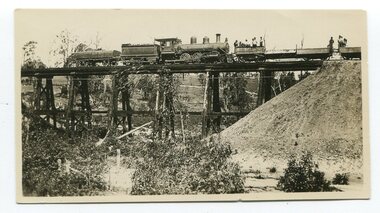
... Gippsland railway line. 3162.2 is possibly Hospital Creek and 3162.3... Gippsland railway line. 3162.2 is possibly Hospital Creek and 3162.3 ...These photographs are probably of bridges on the East Gippsland railway line. 3162.2 is possibly Hospital Creek and 3162.3 possibly Burn Road Newmerella. The Orbost-Bairnsdale railway initially played a crucial role in developing agricultural industries in Gippsland as well as tourism. It opened in 1916 and operated until 1987, principally carrying timber and farming produce. In the early days of the railway's operation dedicated passenger trains ran but these ceased by the 1930s. The line was completely closed to freightage in 1987.The track infrastructure was dismantled in 1994 and has been redeveloped as the East Gippsland Rail Trail.These photographs are associated with the history of the Orbost-Bairnsdale railway line and therefore reflects the role that the rail line played in the social and economic history of Orbost. Three black / white photographs of railway bridges. 3162.1 has a steam train on the bridge. 3162.3 shows three men on the right working at clearing vegetation. 3162.3 has been taken from a height.orbost-bairnsdale-railway east-gippsland-railway bridges-railway -
 Orbost & District Historical Society
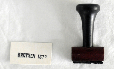
stamp, C 1960's
... 1916 as the terminus of the Orbost railway line, and closed... 1916 as the terminus of the Orbost railway line, and closed ...This stamp was used at the Orbost Railway Station. The Bairnsdale-Orbost railway was opened in 1916 to serve the agricultural and timber industry. Because of the decline in traffic and heavy operating costs, the line was finally closed in August, 1987. Orbost Railway Station was opened on Monday 10 April 1916 as the terminus of the Orbost railway line, and closed in 1987. The station was located on the west side of the Snowy River despite the town of Orbost being on the east side of the river, in order to save on the costs of a bridge over the river, which at the time had highly variable levels This item is associated with the history of the Orbost-Bairnsdale railway line and therefore reflects the role that the rail line played in the social and economic history of Orbost.A stamp with a black plastic handle. The bottom is wood and the stamp rubber. It has "BRUTHEN 1879" on it."BRUTHEN 1879"orbost-railway-station -
 Orbost & District Historical Society
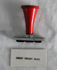
stamp, 1970's
... as the terminus of the Orbost railway line, and closed in 1987... as the terminus of the Orbost railway line, and closed in 1987 ...This stamp was used at the Orbost Railway Station. The Bairnsdale-Orbost railway was opened in 1916 to serve the agricultural and timber industry. Because of the decline in traffic and heavy operating costs, the line was finally closed in August, 1987. Orbost Railway Station was opened on Monday 10 April 1916 as the terminus of the Orbost railway line, and closed in 1987. The station was located on the west side of the Snowy River despite the town of Orbost being on the east side of the river, in order to save on the costs of a bridge over the river, which at the time had highly variable levels, This item is associated with the history of the Orbost-Bairnsdale railway line and therefore reflects the role that the rail line played in the social and economic history of Orbost.A stamp with a red plastic handle and a white stamping face - "ORBOST FREIGHT DEPOT".VUESTAMP AUSTRALIAorbost-railway -
 Kew Historical Society Inc
Photograph, Outer Circle Railway Bridge over River Yarra, c.1900
... of the Outer Circle Railway Line..... It was completed in November 1890 as part of the Outer Circle Railway Line ...This photograph forms part of the Eric Sibly collection of images and information relating to the Outer Circle Railway which he donated to the Kew Historical Society in 1974. Heritage Victoria Citation (Abridged) "The Chandler Highway Bridge, a 137 metre wrought iron lattice-truss girder bridge with four spans supported on red brick piers with moulded bluestone cappings. The bridge has a cantilevered walkway along the west side. ...The Chandler Highway Bridge crosses the Yarra River and connects Alphington and Kew. It was completed in November 1890 as part of the Outer Circle Railway Line.Black & white photograph of the railway viaduct over Yarra River looking south towards Kew.Reverse: "Pre 1930. Outer Circle Railway Bridge over River Yarra (now Chandler Highway) - note bridge over line on Kew side for Asylum Farm". KH - 56. Kew Historical Society.chandler highway, railway bridges - kew (vic), sir john monash, outer circle railway, river yarra - kew (vic) -
 Melbourne Legacy
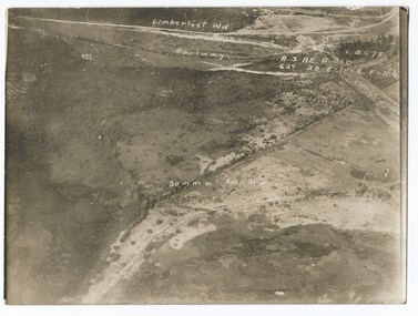
Photograph - Photo, Aerial view of the Somme
... labelled are the railway line and Canal du Nor and Limberlost Wood.... There are coordinates or numbers in some areas. Also labelled are the railway ...An aerial photo of the Somme Swamp in France during World War One. There are coordinates or numbers in some areas. Also labelled are the railway line and Canal du Nor and Limberlost Wood. Was with 11 other photos of World War One that had been mounted on board for display at Legacy House at some stage. When they were taken off display they were put in the archive cabinets. The founding legatees all served in World War One so these photos would have been of significant places for them. (see 01888 to 01899)Photos from World War One that would have been significant to the founding legatees.Sepia photo of the Somme battlefield in France during World War One.world war one, france, somme -
 Melbourne Tram Museum
Slide - Set of 4, Dave Menzies?, 19/04/1973 12:00:00 AM
... in Queens Parade under the Reservoir railway line railway bridge... in Queens Parade under the Reservoir railway line railway bridge ...Set of four colour slides of PCC car 1041 on its debut trip, but that broke down at the corner of Gertrude and Nicholson St. TMSV copy slides. Photographer unknown. Dated 19/4/1973. .1 - In Nicholson St with the Cable Tram winding house in the background. .2 - 1041 reversing and about to pass through the crossover. Has a W tram at the other end that has cleared the tram from the cross over shown in the first slide. .3 - has a W class tram at the rear - could be out of order. .4 - Being towed by W7 1001 in Queens Parade under the Reservoir railway line railway bridge. advertising Stegbar windows and Stott & Son Real Estate. See also Reg Item 6043 for other photos.Keith has written details on each slide including the date and the "TMSV" stamp.trams, tramways, gertrude st, new tramcars, winding houses, tram 1041, pcc class, tram 1001, w7 class, clifton hill -
Glen Eira Historical Society
Article - Rosstown Railway
... Rosstown Sugar Mill Railway line. Concluding with information... behind Rosstown Sugar Mill Railway line. Concluding ...This file contains three items: 1/A review of the ROSSTOWN RAIL TRAIL from LIVING IN GLEN EIRA, vol. 11, 2004, Issue 4, no. 25, date and author unknown. The review explains the purpose of the Rail Trail with a brief narrative of the history behind Rosstown Sugar Mill Railway line. Concluding with information on the location of the Trail and the expected time required to walk the entire track included in the review is a map of the Rail Trail, which marks significant sites along the trail with historic pictures. 2/A newspaper article from THE AGE, dated Tuesday 21/10/1980 and written by Iola Matthews, reporting on the circumstances that led to the publication of the book RETURN TO ROSSTOWN written by Des Jowett and Ian Weickhardt. The article begins with a brief biography of the authors before moving into details of the book’s content, providing a further biography of W. Murray Ross which includes information on his financial ventures – particularly the Rosstown Rail – his marriage and children. The article includes a black and white photograph of Weickhardt and Jowett walking along the route of the railway line, an illustration of the Rosstown sugar works and a map of the area surrounding the site of the mill. 3/Three photocopies of a black and white illustration of the Rosstown sugar works from the east, undated and artist unknown.rosstown rail trail, rosstown, ross william, ross w. murray, ross murray, sugar beet mills, mills, elsternwick, land transport, railways, railway lines, railway routes, carnegie neville street, carnegie miller street, factories, market gardens, horticulture, peat, soils, land forms, topography, geology, civic issues, cone sugar industry, elsternwick plaza, elsternwick, glenhuntly road, parks and reserves, ee gunn reserve, caulfield racecourse, sportsgrounds, caulfield, carnegie, riddell parade, clarence street, aileen avenue, princes park, dover street, marara road, oakleigh road, rosanna street, murrumbeena crescent, north road, kooyong road, hawthorn road, booran road, koornang road, poath road, warragul road, railway platforms, railway buildings, bambra road, swamps, landforms, landfill, council landfill, railway bridges, bridges, railway underpasses, sporting clubs, tennis clubs, bowls clubs, rosstown railway, rosanna street reserve, maps, railway maps, living in glen eira, weickhardt ian, jowett des, caulfield south, curraweena road, oakleigh, caulfield technical school, return to rosstown, beet sugar industry, crops, land booms, land development and subdivisions, bent thomas, fink benjamin, sugar works, rosstown hotel, oamdenong road, rosstown dry cleaners, shops, rosstown road, rosstown plate, people by circumstance, migrants, accountants, occupations, professionals, the grange, real estate, grange road, financial agents, judges, rosstown estate, financial trouble, rabbit preserving, breweries, political debates, political issues, political electorates, politics, political science, debt, financial loans, court procedures, court cases, legal events and activities, malleson and riggall, widowers, seabeach railway, economics, economic deadline, depression 1890s, economic crash, mortgages, divorce, social problems, poverty, ross claude, ross roderick, world war 1914-1918, wars, military history, servicemen, australian flying corps, engineers, caulfield council, swagmen, homelessness, glenhuntly road, glenhuntly road tram, woornack road, leila road, wild cherry road, melten avenue, illustrations, steam trains, trains, horse and cart, horse-drawn transport, railway stations -
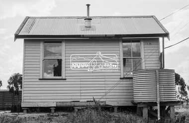
 Eltham District Historical Society Inc
Photograph, Barnes Railway Station, Moama, NSW, November 1962
... . Deniliquin railway line https://en.wikipedia.org/wiki.... Deniliquin railway line https://en.wikipedia.org/wiki ...Barnes station building photographed in November 1962. The railway reached Echuca in 1864 and transformed the town into a major river port, with a famous wharf and substantial urban growth in the 1870s. In 1876 the Deniliquin and Moama Railway Company opened its 71 km (44 mi) private railway northwards to Barnes and Deniliquin, and the line at Echuca was extended across the Murray River into Moama to join the railway. This section was taken over by Victorian Railways in 1923, as part of the 1922 Border Railways Act. Barnes station was closed in 1979. Deniliquin railway line https://en.wikipedia.org/wiki/Deniliquin_railway_lineDigital TIFF file Scan of 35mm Ilford FP3 black and white negative transparencybarnes railway station, echuca, george coop collection, moama