Showing 11442 items
matching maps
-
 Melbourne Tram Museum
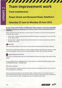
Pamphlet, Yarra Trams, "Tram Improvement work - Power Street and Burwood Road Hawthorn", Jun. 2015
Pamphlet, A4, full colour printed on gloss paper titled "Tram Improvement work - Power Street and Burwood Road Hawthorn" - Saturday 27 June to Monday 29 June 2015/ Gives notes on works, impacts to services and a map along with contact details. 2nd update.trams, tramways, trackwork, power st, burwood rd -
 Bendigo Historical Society Inc.
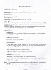
Document - NEW CHUM SYNCLINE MINE - NOTES ON THE NEW CHUM SYNCLINE MINE
Typed copy of notes on the New Chum Syncline Mine on the Nell Gwynne Line of Reef. Notes include depth of shaft, years of working, size of lease, locality, plant, best gold and total gold yield. Small locality map attached to front. Albert Richardson Collection.document, gold, new chum syncline mine, new chum syncline mine, notes on the new chum syncline mine, walker & coy bundaberg, cameron & sutherland, little 180, central deborah, mines department booklet 'bendigo goldfield' 1936, mines dept annual and quarterly reports, a richardson -
 Bendigo Military Museum
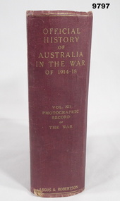
Book - PICTORIAL, WW1, C.E.W. BEAN and H.S. GULLET, "OFFICIAL HISTORY OF AUSTRALIA IN THE WAR OF 1914-18", 1937
From page before title page. "OFFICIAL/ ISTORY/ OF/ AUSTRALIA/ IN THE WAR/ OF 1914-18. VOL. X11/ PHOTOGRAPHI/ RECORD/ OF/ THE WAR". Part of the "William (Bill) THOMASON Collection." Refer Cat No. 4136P for more items.Hard cover book. Cover - cardboard, dark red colour buckram with gold print on spine. Pages are not numbered. White colour glossy paper, cut, plain. Pages 1 to X - Preface. Pages 1 to 753 - Illustrations, black and white photographs and maps at back - index.william (bill) thomason, publication, book, ww1, photographs -
 Bendigo Historical Society Inc.
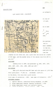
Document - ALBERT RICHARDSON COLLECTION: LADY BARKLY MINE, EAGLEHAWK
One page document, plus map, with information on the Lady Barkly Mine, New Chum line of reef, Eaglehawk. The location, early history, prominence, and gold production are described. References given on bottom of document. Document forms part of research referred to in Albert Richardson's paper 2264.70.bendigo, mining, lady barkly mine eaglehawk -
 Warrnambool and District Historical Society Inc.
Mixed media - Travellers Aid Bag, Travellers Aid bag & Contents, C 1980
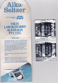
These items were given to clients of the Mid City Motel (probably the one in Ballarat ). The Mid City Motel company was formed in 1963 by a syndicate with the motel in Raglan Parade, Warrnambool. It was later sold with the company liquidated in 1982. The expansion from Warrnambool to Ballarat occurred in 1970 with a building in Doveton Street North, Ballarat. Items such as the sewing kit and shower cap are still given out as promotional material in many motels today. These items are of little importance but are examples of the promotional activities of the motel/tourism scene 30 or so years ago. They may be useful for display.This is a small plastic bag containing a paper sewing kit and a paper folder containing two Alka-Seltser tablets. The sewing kit is red and white and the Alka Seltzer packet is mostly blue. The three items come from the Mid-City Motel and are intended to be kept in a car. Plastic Bag: Mid City Motels, Princes Highway, Warrnambool, 055 62 8026, Doveton Street, Ballarat, 053 31 1222, Travellers Aid Bag for your car with Sewing Kit, Alka Seltzer, Shoe Shine, Shower Cap, Have a Nice Day, Ballarat City Map.warrnambool, mid city motel, tourism -
 Rutherglen Historical Society
Image, 1980
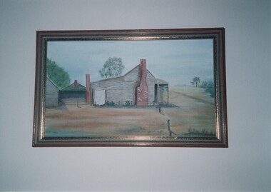
Colour photograph of a painting of a timber buildingWritten on back of photo: "Painted by O.J. Wood 1980 from original photo. Typed on back of photo: "Maddens Wine Hall, & Great Southern Post Office, & Coach Depot Circa 1910. | Located at Map-Ref' 536-074 | (Photo of painting of Mrs O.J. Wood, nee Olcorn)wood family, olcorn family, madden wine hall, great southern post office, coach depot -
 Bendigo Military Museum
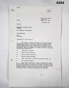
Letter - Army Survey Regiment - Letter of request for additional computer disk space for Automap 2, Army Survey Regiment, 19 Feb 1987
Automap 2 was the Army Survey Regiment's computerized Mapping system. This letter is a request for an additional 700 Mb of computer disk space for the Automap 2 System because of newly developed applications. Those applications were: Analytical Hill shading, Digital Terrain Modelling, Mask and stipple Production, RAAF Chart symbol Placement, ASTIS - Army Survey - Topographic Information System, and, Map Catalog Production.Two page letter, foolscap size, Stapled top left corner"A Spurling, Computer Operations Manager for CO"royal australian survey corps, rasvy, fortuna, army survey regiment, army svy regt, asr -
 Glen Eira Historical Society
Plan - Chinese Community in Glen Eira
Three pages on Chinese in Glen Eira. One hand drawn map of residents living in surrounds of Murton Hall, Chinese Church from SANDS AND MCDOUGALLS 1914 edition by Claire Barton. Printed page from FILE 1234 on Thomson Memorial Church. Hand written Chinese gardeners and related associations from SANDS AND MCDOUGALLS. Page from PROV Book 2013 with a Victorian Garden License.ruby street, reeves william, murton hall, chinese church, malva street, beattie rev. j., ocean street, gould mrs. s., belmont, house names, munn harry, maud street, ormond hall, taylor herbert, raymond rev. h., north road -
Glen Eira Historical Society
Document - Helenslea, Shelford CEGGS
Three copies of a photocopied fold out brochure relating to the auction of 48 lots in the Helenslea Estate on 25/03/1916. The brochure references St Mary’s Church, shops on Glen Eira Road, Caulfield Grammar School, and existing homes in the vicinity and includes photographs of these localities. Reference is also made to available public transport and trees on the Estate. The brochure also includes an illustrated bird’s eye map of the Estate.helenslea estate, glen eira road, st kilda east, mansions, orrong road, balaclava road, caulfield grammar school, fosberry avenue, st mary’s church, land subdivision, land brochures, residential development, auctions, caulfield north -
Tatura Irrigation & Wartime Camps Museum
Photograph, Camp 3
Photographs taken in Camp 3, Tatura. Official group photo including the Girschik family. Children with Father Panico. Departure of internees by train. Map of invasion of Persia by Britain & Russia. Helga Griffin (nee Girschik) addressing the Tatura Historical Society and presenting a dress embroidered in Camp 3 by Helga's mother. Peter Girschik addressing Historical Society, 23 October 2007, two digitised photos.helga griffin, helga girschik, father panico, camp 3 tatura, persia -
 Robin Boyd Foundation
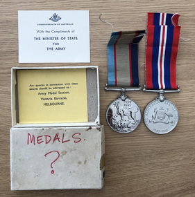
Medal - WWII medals
These are Robin Boyd's World War II medals. Robin Boyd commenced full-time war service on 19 November 1941 and was discharged in September 1945. He spent much of his war service preparing maps in the 3rd Field Survey Company in New Guinea and late in the war near Mareeba, Queensland. The Walsh Street Archive also holds the Demobilization Procedure Book (item D457).awards, honours, robin boyd, walsh st -
Stawell Historical Society Inc
Map - Drawings, Wendy Jacobs, Western Highway Community Precinct Development Structural Drawings, 2014
501 Slab and Footing Plan. 502 Slab and Footing Details. 505 Roof Framing Plan 506 Steel Framing Elevations - Sheet 1. 507 Steel Framing Elevations and Sections - Sheet 2 508 Steel Framing Details - Sheet 1 509 Steel Framing Details - Sheet 2 SN1 General Notes, Site map & Drawing Index Used in building Historical Society Building Eight (8) A1 Printed plans Structural DrwaingsWendy Jacobs Architect & Heritage consultant may 2014 -
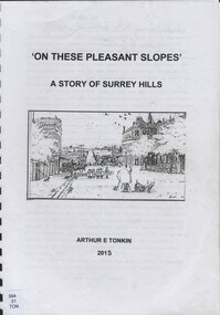 Surrey Hills Historical Society Collection
Book, On these pleasant slope's: a story of Surrey Hills, 2015
Sourced via conversations with those interested in Surrey Hills History. Including Alan Holt, Jack McLean, Frank Bamford, Jocelyn Hall. Includes: Topographical maps, first Elgar Survey. First Wesleyan Church in Surrey Hills. Bibliography on P.50 (last numbered page) Provides a chronological history of Surrey Hills. Includes: First settlers, location, early land sales, commerce and trade.Provides a chronological history of Surrey Hills. Includes: First settlers, location, early land sales, commerce and trade.Back of Title page: To the Surrey Hills Historical / Arthur E. Tonkinfreehold investment and banking company, windsor park estate, (mr) dennis delany, mont albert village, surrey hills - history, royal hotel, surrey hills, humberstone's hotel, chatham state school, holy trinity church, lydswood, lugano, (mr) john butler maling, (mr) john hanlon knipe, mont albert primary school, (mr) james sneddon, (mr) arthur tonkin -
 Surrey Hills Historical Society Collection
Book, Medlow Garden Survey and Landscape capability study 1983, Oct-83
Includes: Plan of Subdivision, Detailed plan, map of garden, Auctioneer's plan for 1854 sale, Botanical plan of Medlow & Landscape history notes. Full title : Medlow Garden survey and landscape capability survey. A report for the National Trust of Australia (Victoria) A report giving a detailed landscape survey of Medlow Garden estate. Includes landscape story, cultural significance, particulars about vegetarian, garden, rehabilitation and plans.Copy of a report giving a detailed landscape survey of Medlow Garden estate. Includes landscape story, cultural significance, particulars about vegetarian, garden, rehabilitation and plans. 38 pages with illustrations.land surveys, medlow garden, bismark estate, rosalie estate, warrigal road, surrey hills, bismarck avenue, warwick avenue, t p payne, (mr) hugh glass, boroondara, (mr) (maj) - cairncross, (mrs) mary jane cairncross, (dr) (mr) richard joseph bull, (mrs) catherine grace bull, (miss) norma bull, (mr) ronald richard bull, medlow -
 Surrey Hills Historical Society Collection
Book, Medlow Garden Survey and Landscape capability study 1983, Oct-83
Includes: Plan of Subdivision, Detailed plan, map of garden, Auctioneer's plan for 1854 sale, Botanical plan of Medlow & Landscape history notes. Full title : Medlow Garden survey and landscape capability survey. A report for the National Trust of Australia (Victoria) A report detailing the landscape survey of Medlow Garden estate. Includes landscape history, cultural significance, particulars about vegetarian, garden, rehabilitation and plans.A report detailing the landscape survey of Medlow Garden estate. Includes landscape history, cultural significance, particulars about vegetarian, garden, rehabilitation and plans. 38 p illland surveys, medlow garden, bismark estate, rosalie estate, warrigal road, surrey hills, bismarck avenue, warwick avenue, t p payne, (mr) hugh glass, boroondara, (maj.) (mr) - cairncross, (mrs) mary jane cairncross, (dr)(mr) richard joseph bull, (mrs) catherine grace bull, (miss) norma bull, (mr) ronald richard bull, medlow, house names, (mr) rex swanson, landform australia -
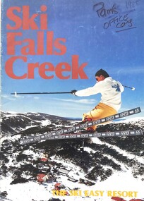 Falls Creek Historical Society
Magazine - Ski Falls Creek - The Ski Easy Resort
A part of a yearly marketing magazine promoting Falls Creek ski region for the winter holidays. It includes 24 pages of detailed information and maps describing resort facilities, different runs and access to the snow. Available accommodation is explained with the inclusion of tariffs for 25 different venues in both lodges and apartments. Transport, ski hire, other village services and insurance and booking agents are also explained. The brochure was published by Victour.This item is important as it documents seasonal activities at Falls Creek Alpine ResortAn A4 sized magazine titled "Ski Falls Creek - The Ski Easy Resort". It consists of 24 pages of information and images.falls creek 1985, the ski easy resort, falls creek marketing, falls creek maps, falls creek activities -
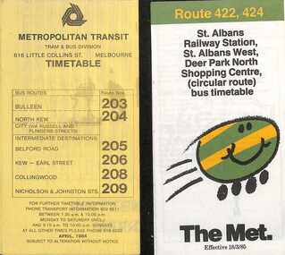 Melbourne Tram Museum
Ephemera - Timetables - The Met - buses - set of 2, The Met, 1984 and 1985
Timetables - provide information on ticketing, fares, timing points, with a description of the route and a map. 1 - Bulleen - North Kew - City, Belford Rd, Collingwood - routes 203, 204, 205, 206, 208, 209 - with the first "The Met" logo - April 1984 2 - St Albans - Deer Park North Shopping Centre - circular route - with the smiley face on wheels logo - dated 18/3/1985.Yields information about MMTB Bus services during the mid 1980s. Set of two The Met timetables, one printed on the folded sheet of yellow paper and the other on white paper.timetable, bulleen, north kew, collingwood, the met, deer park, st albans -
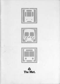 Melbourne Tram Museum
Document - Informaion booklet / folder, The Met, "The Met", late 1980s
Information document about The Met, its services, forward plans, trams, trains, buses. Includes maps showing where upgrades were planned, including roads, and electrification of rail lines. Has a forward by Kevin Shea the Managing Director of The Met. Undated, late 1980s, based on the text with some dates. Has a photo of B2 class tram No. 2005. Notes the completion of the Hong Kong project in 1988.Provides infomation about the forward planning of The Met in late 1980s.Document - 16 pages including folded out sheet + card covers.melbourne, tramways, trams, the met, mta, railways, buses, planning -
 Warrnambool and District Historical Society Inc.
Booklets Fletcher Jones, 001143.1 Project Book 001143.2 Booklet:Plusites 001143.3 Flyer, Mid 20th century
Fletcher Jones Clothing Factory was a key industry in Warrnambool from 1948 to its closure in 2005. The business was founded by David Fletcher Jones (1897-1977), a clothing manufacturer and retailer who worked as a hawker in the Western District following service with the A.I.F. in World War One. In 1924 Fletcher Jones opened three shops in Liebig Street selling men’s wear, hosiery and linen and operating a small tailoring business. He moved his shop to another location in Liebig Street and began to concentrate on men’s trousers production. In 1946 he opened a shop in Collins Street in Melbourne and eventually had stores and factories all over Australia. In Warrnambool he opened his factory at Pleasant Hill in Flaxman Street in 1948 and became a major Warrnambool employer, with over 1000 employees at one time. He transformed his business into a co-operative, with the name, ‘Fletcher Jones and Staff’ registered in 1947. The business diversified into other ranges of clothing for men and women but failed to compete with cheaper overseas clothing imports and the factory and shops were closed in the early 21st century. 001143.1 Project Book. This project book tells the story of the establishment and development of the Fletcher Jones company across the various stores which were established in Melbourne, Adelaide, Sydney, Geelong and Hobart. It explores the philosophy behind the business and milestones achieved and the factory gardens. The book itself provides an example of schoolwork completed in the mid 20th century. 001143.2 Booklet: Plusites: This is a staff booklet which has items of interest relating to staff such as births deaths and marriages. It tells of renovations and happenings in regard to the various shops around the country as well as trading figures. It tells of the royal visit of 1954 and other social events and items of interest around the various shops. 001143.3 Flyer :The text on this flyer also tells the story of the development of the Fletcher Jones brand to the point where there in the year2000 retail expansion was still happening but the Warrnambool workforce had shrunk from over 1000 at the peak to approximately 200. The company had commenced importing a range of clothing by this time These three items present different views of a company which was an important part of industry in Warrnambool for over 60 years in the latter part of the 20th century. The founder was one of Warrnambool’s most well respected people and many district people had connections to the firm. 001143.1 Project Book. Brown mottled card cover with cream insert for personal details. Back cover plain cream. It contains a student’s project work on the Fletcher Jones company. Some is handwritten and also contains a number of black and white photographs throughout the book. A coloured map of Australia is in the middle pages. 001143.2 Booklet: Plusites. White light card cover with dark blue text and diagram. Bottom left of page has a map of the coastline of Victoria. 20 pages. 001143.3 Flyer. Advertising Flyer re factory direct sales at Warrnambool. Black text with maroon border and Fletcher jones logo at the bottom and 4 photographs at the top. 001143.1 Project Book. T Cronin 4B WHS 001143.2 Booklet: Plusites. Vol 1 No 1 June 1954. 001143.3 Flyer fletcher jones, warrnambool history, fletcher jones and staff pty ltd -
 Bendigo Historical Society Inc.
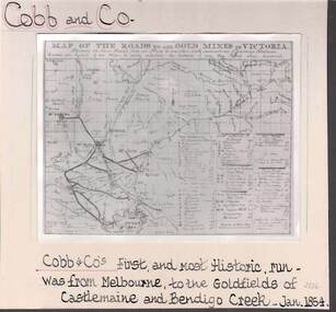
Photograph - COBB & CO,., MAP OF COACH RUN TO BENDIGO
black and white image ( copy ) on board : image shows map of roads to all gold mines in Victoria., showing Cobb & Co., routes. Written on board: Cobb and Co., Cobb & Co's first and most historic run was from Melbourne to the goldfields of Castlemaine and Bendigo Creek, Jan 1854./// image shows -'Map of the roads to all gold mines in Victoria., showing the Cross roads from one mine to another with indications of various stations divided into squares of ten miles to easily calculate the distance of any new mines when discovered ///There is a list of towns with their distance from Melbourne and to & from distances for other destinations Cobb & Co., routesbusiness, transport, cobb & co., cobb & co., bendigo, transport -
Southern Sherbrooke Historical Society Inc.
Information folder - Auxilium College
Folder containing items pertaining to history of Auxilium College, Lysterfield. Contents: -"Tarella Quin" - article by Margaret McInnes, photocopy of Knox Historian Vol. 4 No.1 May 1992, pp. 42-65 -"Salesian serenity" - article by Scott Spits, photocopy of Knox News, Dec. 1, 1998, pg. 9 -"Auxilium College formerly known as Leasowes", information sheet prepared for Southern Sherbrooke H.S. Heritage Week tour, April 2002 -"Map to get from Auxiliun College to Mount Heatherley", map prepared for tour -article. "The Life & Works Of Tarella Quin". Knox Historical Journal, 2006 -photos, eleven, taken during our tour -
 Ballarat Tramway Museum
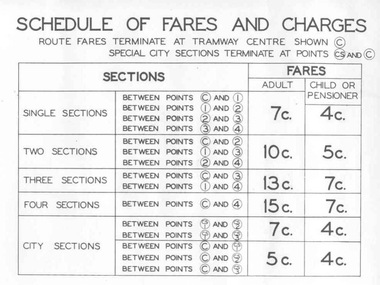
Poster, State Electricity Commission of Victoria (SECV), "Schedule of Fares and Charges - August 1966", Aug. 1966
Demonstrates an aspect of the SEC method of advising fares and sections to the travelling public. Also gave a small map that would have been useful to crews to explain to visitors where things were. Used in tramcars when trimmed. This poster made for the 1966 or second last fare increase. A similar arrangement used on Bendigo tramcars.Dyeline print of a drawing showing Ballarat Tramway (SEC) Fares, Charges, and Section Map. Also gives charges for Scholar's Monthly tickets, Luggage, Parcels, Newspapers and Chartered trams. Originally dated August 1965, amended August 1966. Note only shows decimal currency. Fares were applicable from 1/9/1966. Titled - "Schedule of Fares and Charges - August 1966" 2nd copy added 1/5/2001 - In good condition and images added as well. 3rd copy added 3-8-2006 - BTPS Cat. No. 608 - folded into four. For map - see blrtfcmap.jpg and for actual fare tables, btm705i1.jpg, btm705i2.jpg"BTPS 608" on outside of folded sheet in black ink and "Ballarat Tramway Preservation Society Catalogue No. 608" on top right hand corner of sheet.trams, tramways, ballarat, fares, sections, map -
 Ballarat Tramway Museum
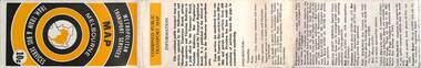
Map, Ministry of Transport, "Metropolitan Transport Services Map - Melbourne - Tram and Bus Services", c1970
Pocket size - folded - public transport map of Melbourne, printed in colours showing the bus, train and tram routes around Melbourne. Has a cover price of 10c. No printing date shown, but c1970 as distances are still in imperial, the West gate bridge is shown, though so is the Williamstown Ferry. Gives telephone numbers in 6 digit figures. Lists route numbers for trams, tramways board bus services and private services. Gives various telephone numbers for further information. Notes the map is a combined effort of the Tramways Board, Victorian Railways, Bus Proprietors' Association and the Transport Regulation Board. Single sheet of paper folded in 9 x 3 folds.trams, tramways, melbourne, map, public transport, routes -
Bendigo Historical Society Inc.
Booklet - Frontier Life in the Loddon Protectorate, 1967
95-page light cover booklet of Episodes from Early Days 1837-1842 in the Loddon Aboriginal Protectorate in Victoria. By Edgar Morrison. Map showing the approximate limits of the Protectorate in Victoria on title page. Map of early station boundaries on page iv. Sketch of an Aborigine holding a spear on front cover. Illustrated with B&W photos. B&W photo of Edward Stone Parker (1802-1865) Protector of Aborigines in the Loddon District. A reprint of Parker's Lecture on the Aborigines of Australia, May 10, 1854, is given in a 31-page section at the back. Foreword by Edgar Morrison Feb. 1967. Hugh McColl, Printer, 'Banner' Office, Latrobe StreetHandwritten in ink on front page. 'To Mr A. Chisholm from Alan J. Hardy (?)aborigines, loddon protectorate, edgar morrison, edward stone parker -
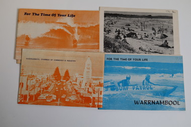 Warrnambool and District Historical Society Inc.
Booklet - Warrnambool Tourist Guides (5), Warrnambool Chamber of Commerce and Industry, Warrnambool - For the Time of Your Life, 1970-1975
Warrnambool Tourist Guides 1970-1975.1,.2,.3 - These are booklets of 36 pages with an orange cover with an illustration of two people on surf boards on the front cover and an image of a main street on the back cover. The cover has blue printing. The pages contain a map, advertisements, black and white photographs and printed text. One booklet is stapled and two have the staples removed. .4,.5 -These are booklets of 40 pages with a front cover with a photograph in blue tones of a surf patrol boat and two lifesavers and a back cover with a black and white photograph (beach scene). The pages contain a map, advertisements, black and white photographs and printed text. One booklet is stapled and one has the staples removed. non-fictionWarrnambool Tourist Guides 1970-1975warrnambool tourism, tourism in warrnambool in the 1970s -
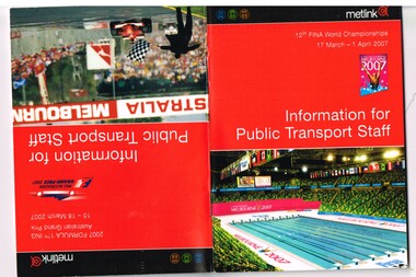 Melbourne Tram Museum
Book, Yarra Trams, "Information for public transport staff - 2007 FINA World Championships", "Information for public transport staff - 2007 Formula 1 Australian Grand Prix", Mar. 2007
Sixty four full colour publication plus covers "Information for public transport staff - 2007 Formula 1 Australian Grand Prix" and when turned upside down - "Information for public transport staff - 2007 FINA World Championships" (Swimming) Gives details of event for train, tram and bus crews, event program and transport map, including shunting details, announcements, bus replacement services, electric or automatic points, route alterations. On the back cover has contact telephone numbers and web addresses. See Reg Item 1064 for associated map. Item contained with in a plastic envelope with a black neck band. 2 copies held.trams, tramways, grand prix, metlink, formula 1, albert park, fina -
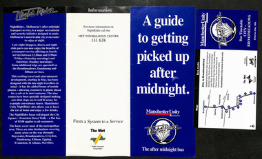 Melbourne Tram Museum
Pamphlet, Public Transport Corporation (PTC), "A guide to getting picked up after midnight", May. 1993
Pamphlet - titled "A guide to getting picked up after midnight" consisting of a 3 fold DL pamphlet and 8 bus night or night rider timetables. The DL 3 fold pamphlet sponsored by Manchester Unity and Fox FM introduced the 1993 service. Has a map of the various services and a brief suburb by suburb description. Has contact numbers and the logos of The Met and the PTC. The forerunner to night trams and trains. 8 timetables, each with a map list of stops and times. Operated Saturdays and Sundays only - dated May 1993. Each have two creases to enable folding. Werribee, Broadmeadows, St Albans, Epping, Eltham, Croydon, Boronia, Dandenong, Frankstontrams, tramways, nightrider, night trams -
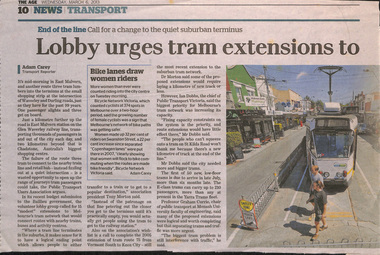 Melbourne Tram Museum
Newspaper, The Age, "Lobby urges tram extensions to avoid dead end trips", 6/03/2013 12:00:00 AM
Newspaper clipping from The Age, 6/3/2013, titled "Lobby urges tram extensions to avoid dead end trips" about extending existing tram lines to stations to make better transport connections and interchanges. Has a map showing possible extension. Written by Adam Carey with comments from Tony Morton, Ian Dobbs (comments about capacity issues), Graham Currie. Map shows 15 extensions. Adjacent to the item is an article about the Rowville train line extension. Has a photo of Z1 at the East Malvern terminus and box about women making use of bicycle lanes. Item spread over two sheets.trams, tramways, melbourne, tramways, new tramway, east malvern -
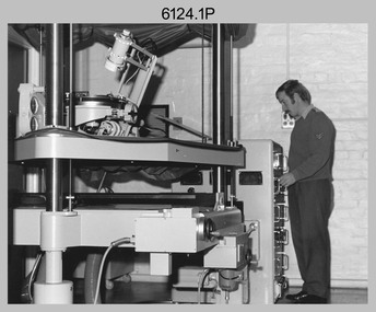 Bendigo Military Museum
photograph - Orthorectification Equipment - Army Survey Regiment, Fortuna, Bendigo, c1975
Orthophoto mapping provided the Survey Corps with the capability to produce map products quickly in the event of a crisis. These are four photographs of equipment used by the Army Survey Regiment to produce orthophotomaps. The Wild GZ1 orthophoto projector was introduced in 1973 and was the first equipment used to orthorectify colour and monochrome film aerial photography. Height profiles were originally produced on a PEB8 Stereo profiler and later were software generated. Photos of the PEB8 are available in Victorian Collections item 6222.17P, photos .5P and .6P. In the same era the IBM 1130 computer; OMI/Nistri AP/C-3 analytical plotter with coordinatograph, OP/C orthophoto projector and Zeiss Planimat D2 stereoplotters were introduced. Orthorectification is the process of removing geometric distortions and scale errors/variations from images. Images have tilt and relief distortions that make it difficult to compare accurately a map and an image of the same geographic area. Once an image is orthorectified, features on the image are shown in their planimetric locations. These four photographs of orthorectification equipment were taken at the Army Survey Regiment at Fortuna, Bendigo, c1975. Photo .1P and .3P were printed on photographic paper and scanned at 300 dpi. Photos .2P, .4P and .5P were on 35mm negative film and scanned at 96 dpi. They are part of the Army Survey Regiment’s Collection. .1) - Photo, black & white, c1975, Wild GZ1 orthophoto projector operated by CPL Phil Boyle. .2) - Photo, black & white, c1975, Wild GZ1 orthophoto projector. .3) - Photo, black & white, c1975, Wild GZ1 orthophoto projector. .4) - Photo, black & white, c1978, Zeiss D2 Planimat Stereoplotter. .5) - Photo, black & white, c1978, Zeiss D2 Planimat Stereoplotter..1P to .5P No annotations.royal australian survey corps, rasvy, army survey regiment, army svy regt, fortuna, asr -
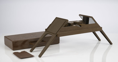 Department of Energy, Environment and Climate Action
Foldable Stereoscope
This stereoscope was used to view a pair of separate and overlapping aerial photos as a single three-dimensional image. This smaller foldable unit could be easily used in the field but larger, mirror stereoscope was used in offices. The aerial images were used to map forest types, timber stands, new roads and tracks, firebreaks, boundaries of timber harvesting, plantations, bushfires, insect and disease attack and so on In 1928, the Forests Commission undertook its first major aerial photography project over 15,000 acres of forest which is said to be the first of its kind in Australia. During the Second World War, large areas of Victoria were photographed by RAAF and used to produce orthophoto maps. By 1945 aerial photography of 13,000 square miles (3.4 M ha) was completed, including much of the inaccessible eastern forests. The Forests Commission started developing its own small format photography in the early 1970s. Simple, cheap and rapid methods of obtaining photographs using 70mm and 35mm cameras were developedFoldable plastic stereoscope in box Benallaforests commission victoria (fcv), surveying, forest measurement