Showing 11451 items matching "maps "
-
 Ballarat Tramway Museum
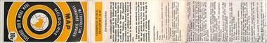
Map, Ministry of Transport, "Metropolitan Transport Services Map - Melbourne - Tram and Bus Services", c1970
Pocket size - folded - public transport map of Melbourne, printed in colours showing the bus, train and tram routes around Melbourne. Has a cover price of 10c. No printing date shown, but c1970 as distances are still in imperial, the West gate bridge is shown, though so is the Williamstown Ferry. Gives telephone numbers in 6 digit figures. Lists route numbers for trams, tramways board bus services and private services. Gives various telephone numbers for further information. Notes the map is a combined effort of the Tramways Board, Victorian Railways, Bus Proprietors' Association and the Transport Regulation Board. Single sheet of paper folded in 9 x 3 folds.trams, tramways, melbourne, map, public transport, routes -
 Bendigo Historical Society Inc.
Booklet - Frontier Life in the Loddon Protectorate, 1967
95-page light cover booklet of Episodes from Early Days 1837-1842 in the Loddon Aboriginal Protectorate in Victoria. By Edgar Morrison. Map showing the approximate limits of the Protectorate in Victoria on title page. Map of early station boundaries on page iv. Sketch of an Aborigine holding a spear on front cover. Illustrated with B&W photos. B&W photo of Edward Stone Parker (1802-1865) Protector of Aborigines in the Loddon District. A reprint of Parker's Lecture on the Aborigines of Australia, May 10, 1854, is given in a 31-page section at the back. Foreword by Edgar Morrison Feb. 1967. Hugh McColl, Printer, 'Banner' Office, Latrobe StreetHandwritten in ink on front page. 'To Mr A. Chisholm from Alan J. Hardy (?)aborigines, loddon protectorate, edgar morrison, edward stone parker -
 Warrnambool and District Historical Society Inc.
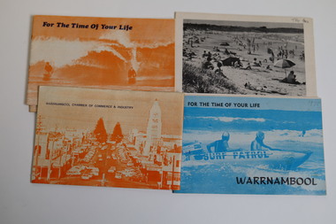
Booklet - Warrnambool Tourist Guides (5), Warrnambool Chamber of Commerce and Industry, Warrnambool - For the Time of Your Life, 1970-1975
Warrnambool Tourist Guides 1970-1975.1,.2,.3 - These are booklets of 36 pages with an orange cover with an illustration of two people on surf boards on the front cover and an image of a main street on the back cover. The cover has blue printing. The pages contain a map, advertisements, black and white photographs and printed text. One booklet is stapled and two have the staples removed. .4,.5 -These are booklets of 40 pages with a front cover with a photograph in blue tones of a surf patrol boat and two lifesavers and a back cover with a black and white photograph (beach scene). The pages contain a map, advertisements, black and white photographs and printed text. One booklet is stapled and one has the staples removed. non-fictionWarrnambool Tourist Guides 1970-1975warrnambool tourism, tourism in warrnambool in the 1970s -
 Melbourne Tram Museum
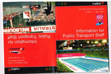
Book, Yarra Trams, "Information for public transport staff - 2007 FINA World Championships", "Information for public transport staff - 2007 Formula 1 Australian Grand Prix", Mar. 2007
Sixty four full colour publication plus covers "Information for public transport staff - 2007 Formula 1 Australian Grand Prix" and when turned upside down - "Information for public transport staff - 2007 FINA World Championships" (Swimming) Gives details of event for train, tram and bus crews, event program and transport map, including shunting details, announcements, bus replacement services, electric or automatic points, route alterations. On the back cover has contact telephone numbers and web addresses. See Reg Item 1064 for associated map. Item contained with in a plastic envelope with a black neck band. 2 copies held.trams, tramways, grand prix, metlink, formula 1, albert park, fina -
 Melbourne Tram Museum
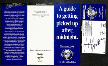
Pamphlet, Public Transport Corporation (PTC), "A guide to getting picked up after midnight", May. 1993
Pamphlet - titled "A guide to getting picked up after midnight" consisting of a 3 fold DL pamphlet and 8 bus night or night rider timetables. The DL 3 fold pamphlet sponsored by Manchester Unity and Fox FM introduced the 1993 service. Has a map of the various services and a brief suburb by suburb description. Has contact numbers and the logos of The Met and the PTC. The forerunner to night trams and trains. 8 timetables, each with a map list of stops and times. Operated Saturdays and Sundays only - dated May 1993. Each have two creases to enable folding. Werribee, Broadmeadows, St Albans, Epping, Eltham, Croydon, Boronia, Dandenong, Frankstontrams, tramways, nightrider, night trams -
 Melbourne Tram Museum
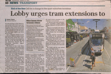
Newspaper, The Age, "Lobby urges tram extensions to avoid dead end trips", 6/03/2013 12:00:00 AM
Newspaper clipping from The Age, 6/3/2013, titled "Lobby urges tram extensions to avoid dead end trips" about extending existing tram lines to stations to make better transport connections and interchanges. Has a map showing possible extension. Written by Adam Carey with comments from Tony Morton, Ian Dobbs (comments about capacity issues), Graham Currie. Map shows 15 extensions. Adjacent to the item is an article about the Rowville train line extension. Has a photo of Z1 at the East Malvern terminus and box about women making use of bicycle lanes. Item spread over two sheets.trams, tramways, melbourne, tramways, new tramway, east malvern -
 Bendigo Military Museum
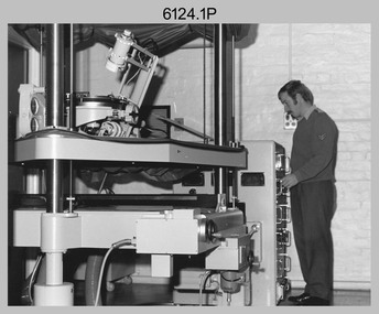
photograph - Orthorectification Equipment - Army Survey Regiment, Fortuna, Bendigo, c1975
Orthophoto mapping provided the Survey Corps with the capability to produce map products quickly in the event of a crisis. These are four photographs of equipment used by the Army Survey Regiment to produce orthophotomaps. The Wild GZ1 orthophoto projector was introduced in 1973 and was the first equipment used to orthorectify colour and monochrome film aerial photography. Height profiles were originally produced on a PEB8 Stereo profiler and later were software generated. Photos of the PEB8 are available in Victorian Collections item 6222.17P, photos .5P and .6P. In the same era the IBM 1130 computer; OMI/Nistri AP/C-3 analytical plotter with coordinatograph, OP/C orthophoto projector and Zeiss Planimat D2 stereoplotters were introduced. Orthorectification is the process of removing geometric distortions and scale errors/variations from images. Images have tilt and relief distortions that make it difficult to compare accurately a map and an image of the same geographic area. Once an image is orthorectified, features on the image are shown in their planimetric locations. These four photographs of orthorectification equipment were taken at the Army Survey Regiment at Fortuna, Bendigo, c1975. Photo .1P and .3P were printed on photographic paper and scanned at 300 dpi. Photos .2P, .4P and .5P were on 35mm negative film and scanned at 96 dpi. They are part of the Army Survey Regiment’s Collection. .1) - Photo, black & white, c1975, Wild GZ1 orthophoto projector operated by CPL Phil Boyle. .2) - Photo, black & white, c1975, Wild GZ1 orthophoto projector. .3) - Photo, black & white, c1975, Wild GZ1 orthophoto projector. .4) - Photo, black & white, c1978, Zeiss D2 Planimat Stereoplotter. .5) - Photo, black & white, c1978, Zeiss D2 Planimat Stereoplotter..1P to .5P No annotations.royal australian survey corps, rasvy, army survey regiment, army svy regt, fortuna, asr -
 Department of Energy, Environment and Climate Action
Foldable Stereoscope
This stereoscope was used to view a pair of separate and overlapping aerial photos as a single three-dimensional image. This smaller foldable unit could be easily used in the field but larger, mirror stereoscope was used in offices. The aerial images were used to map forest types, timber stands, new roads and tracks, firebreaks, boundaries of timber harvesting, plantations, bushfires, insect and disease attack and so on In 1928, the Forests Commission undertook its first major aerial photography project over 15,000 acres of forest which is said to be the first of its kind in Australia. During the Second World War, large areas of Victoria were photographed by RAAF and used to produce orthophoto maps. By 1945 aerial photography of 13,000 square miles (3.4 M ha) was completed, including much of the inaccessible eastern forests. The Forests Commission started developing its own small format photography in the early 1970s. Simple, cheap and rapid methods of obtaining photographs using 70mm and 35mm cameras were developedFoldable plastic stereoscope in box Benallaforests commission victoria (fcv), surveying, forest measurement -
 Department of Energy, Environment and Climate Action
Stereoscope
This stereoscope was used to view a pair of separate and overlapping aerial photos as a single three-dimensional image. Smaller units and could be easily used in the field but this larger, mirror stereoscope was used in offices. The aerial images were used to map forest types, timber stands, new roads and tracks, firebreaks, boundaries of timber harvesting, plantations, bushfires, insect and disease attack and so on In 1928, the Forests Commission undertook its first major aerial photography project over 15,000 acres of forest which is said to be the first of its kind in Australia. During the Second World War, large areas of Victoria were photographed by RAAF and used to produce orthophoto maps. By 1945 aerial photography of 13,000 square miles (3.4 M ha) was completed, including much of the inaccessible eastern forests. The Forests Commission started developing its own small format photography in the early 1970s. Simple, cheap and rapid methods of obtaining photographs using 70mm and 35mm cameras were developedFoldable metal stereoscope in wooden box with mirror covers Ex Dept of Defenceforests commission victoria (fcv), surveying, forest measurement -
 Bendigo Military Museum
Photograph - Army Survey Regiment - Fortuna & Surrounds, Bendigo, c1985
This set of 30 photographs of the Army Survey Regiment’s Fortuna Villa and surrounding facilities was taken circa 1985. The photos feature much of Fortuna’s exterior and most of the out-buildings spread over the property’s fifteen acres of grounds. After Defence took possession of Fortuna in 1942, the Q-store and engineering workshops were added during the wartime period. Soldiers were accommodated in tents during WW2 for 20 years next to the parade ground before the construction of accommodation buildings in 1962. In 1990 most of the weatherboard buildings in the Q-store area were replaced. A climate-controlled building was also constructed to house a map library and digital data media. This photo set also includes the exterior of Air Survey Squadron’s Building 16 and two modular buildings -16A and 16B that were added in the early 1980s to accommodate map production and technical services. See item 6457.22P for photos of Fortuna Villa’s interior that were taken at the same time.This set of 30 photographs of the Army Survey Regiment’s Fortuna Villa and surrounding facilities was taken circa 1985. The colour photographs were printed on photographic paper and are part of the Army Survey Regiment’s Collection. The photographs were scanned at 300 dpi. .1) - Photo, colour, c1985. Fortuna Villa – view from the lake. .2) to .4) - Photo, colour, c1985. Fortuna Villa – front view. .5) - Photo, colour, c1985. Fortuna Villa – balcony view of transport compound and Air Survey Squadron. .6) - Photo, colour, c1985. Fortuna Villa – balcony view of Q-store and transport compound. .7) - Photo, colour, c1985. Fortuna Villa – balcony view of transport compound and Bendigo. .8) - Photo, colour, c1985. Fortuna Villa – balcony view of Q-store buildings. .9) - Photo, colour, c1985. Fortuna Villa – Pompeii Fountain and Stables. .10) - Photo, colour, c1985. Fortuna Villa – coach house. .11) - Photo, colour, c1985. Lithographic Squadron delivery docks. .12) - Photo, colour, c1985. Fortuna Villa - Original Roman Bath entry. .13) - Photo, colour, c1985. RAEME and carpentry buildings. .14) - Photo, colour, c1985. Q-store buildings. .15) - Photo, colour, c1985. Q-store buildings. .16) - Photo, colour, c1985. Transport compound. .17) - Photo, colour, c1985. Fortuna Villa’s original laundry, gardeners’ building. .18) - Photo, colour, c1985. Duty Room. .19) - Photo, colour, c1985. L to R: Side of Duty Room, RAP building. .20) - Photo, colour, c1985. Transport compound, Q-store in background. .21) - Photo, colour, c1985. Air Survey Squadron’s Building 16 viewed from carpark. .22) - Photo, colour, c1985. Technical Services, Building 16B. .23) - Photo, colour, c1985. Air Survey Squadron’s Building 16 courtyard. .24) - Photo, colour, c1985. Technical Services, Building 16B viewed from Building 16 courtyard. .25) - Photo, colour, c1985. Air Survey Squadron’s Building 16A and fernery viewed from walkway. .26) - Photo, colour, c1985. Officers Accommodation. .27) - Photo, colour, c1985. Other Ranks (OR’s) ‘New’ Barracks. .28) - Photo, colour, c1985. OR’s Kitchen and Dining Room. .29) & .30) - Photo, colour, c1985. Army Survey Regiment - Front Entry GateThere are brief descriptions on a note behind each photograph.royal australian survey corps, rasvy, army survey regiment, army svy regt, fortuna, asr -
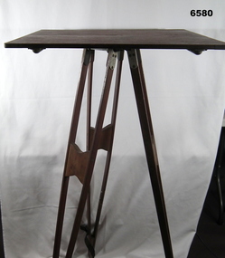 Bendigo Military Museum
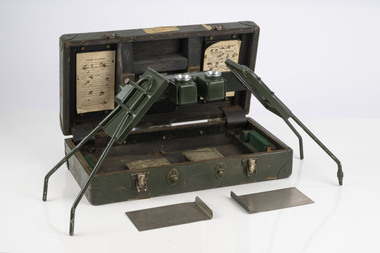
Instrument - Survey Plane Table with Tripod, Circa 1910
A Plane Table consists of a smooth wooden table surface (with metal strengthening supports) mounted on a sturdy base. The base, a three-legged Tripod, is designed to support the table over a specific point on land. The connection between the tabletop and the adjustable Tripod legs permits the user to level the table precisely, using bubble levels in a horizontal plane regardless of the roughness of the terrain. The Plane Table is a surveying device used in surveying and mapping to provide a level surface on which to make drawings, charts or maps. An alidade, with or without a telescope located on the tabletop is used to sight features and draw angles to that feature. Using these lines to the same feature from different setup locations it is possible to locate that feature on the map. Plane Tabeling was widely used by the early members of the Australian Survey Corps and in both World Wars. It remains a simple and effective tool to teach the fundamentals of mapping and surveying. It was simple to use and was reasonably robust and portable. See also item 6489.2 for the Plane Table Alidade.A wooden Plane Table with alloy fittings to strengthen and support the table top. The table is fixed to a three-legged wooden Tripod with cast alloy fittings and metal pointed tips.royal australian survey corps, rasvy, fortuna, army survey regiment, army svy regt, asr, 4 fd svy sqn, school of military survey -
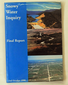 Orbost & District Historical Society
book, Snowy Water Inquiry, Snowy Water Inquiry Final Report, 1998
The Snowy Water Inquiry was commissioned in 1998 with a brief to recommend environmental water release options to the Commonwealth, Victorian, and NSW Governments so that corporatisation of the Snowy Mountains Scheme could proceed. These release options related to the Snowy River below Jindabyne, the Murray River and other rivers associated with the Scheme. The Inquiry objectives were that the recommendations would not adversely impact on water supplies to existing irrigators or the viability of the Snowy Mountains Scheme. (ref snowyhydro.com.au)This report contains information about water allocation and uses of the Snowy River.A book of 160 pp - Snowy River Inquiry Final report 23rd October 1998. Submitted to the Governments of New South Wales and Victoria / Commissioner: The Hon. Robert Webster. On the front cover are three aerial photographs of the Snowy River and Snowy Hydro Scheme. The book contains maps and photographs. snowy-river snowy-hydro snowy-mountains government-inquiry -
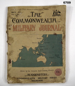 Bendigo Military Museum
Book - MILITARY JOURNAL
Journal issued by Commonwealth General Staff covering various aspects of Military Activities. Used as a training source by Military Servicemen.Brown A.4 size book with 201 pages issued May 1911 whose contents cover various aspects of Military Battlefield Donations. Cover has Commonwealth Emblem, Title, Volume No. and map covering Asian, African and Australian Zones. Military Journal in Red, large metal staples.Headed "The Commonwealth Military Journal Vol 1, May 1911. "Edited by General Staff (Training Branch), Commonwealth Military Forces Melbourne".passchendaele barracks trust, book, military training, ww1 -
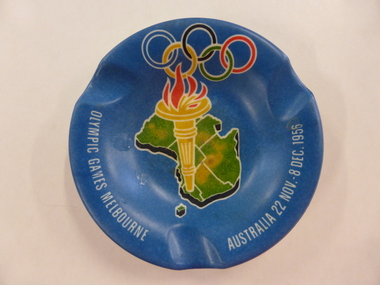 Warrnambool and District Historical Society Inc.
Promotion, Olympic games Melb 1956, 1956
This ash tray is a souvenir of the Olympic Games held in Melbourne in 1956. This was an important event in post World War Two Australia and the first time the Olympic Games had been held in the Southern Hemisphere. The Opening and Closing Ceremonies, the athletics events and some other events were held at the Melbourne Cricket Ground. These were the first televised Olympic Games. To mark the occasion many souvenir items were produced for tourists and collectors.This item is kept as a memento of the 1956 Melbourne Olympic Games, an event that interested and affected all Australians as it made Melbourne and Australia via press and television coverage etc. the centre of attention in the world at the time. It is also a memento that would no longer be made or sold today as cigarette smoking in general is no longer socially and medically acceptable. It will be useful for display.This is a plastic circular ash tray. It has a blue base with a multi-coloured image in the centre of the base of a map of Australia, an Olympic Games torch and the Olympic Games ring motifs. The printing is in white and the name of the maker is embossed on the back of the tray. There are three indents around the base for stubbing out the cigarettes. ‘Olympic Games Melbourne Australia 22 Nov. - 8 Dec. 1956’ ‘British Plastics Pty Ltd Melbourne Reg. Des.’ olympic games melbourne, 1956 olympics -
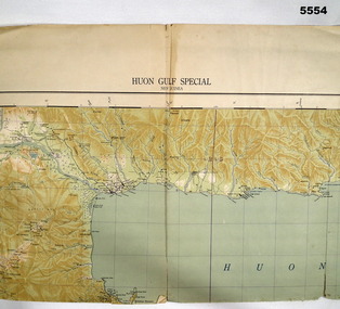 Bendigo Military Museum
Map - MAP, HUON GULF AREA, Aust Survey Corps et al, Aug 43
Refer Cat 5547 - Matheson.This is a single sided map, printed in colour. Scale 1:253,440, 4 miles to an inch, grid squares are 10mm x 10mm. Top right side shows Finschafen. Top centre is Lae, Middle is Salamau. Bottom is Lasanga Island. Top left vicinity is Nadzab and Markham River.There are four "corner" marks in pencil. Two on land and two out in the gulf.ww2, new guinea, map -
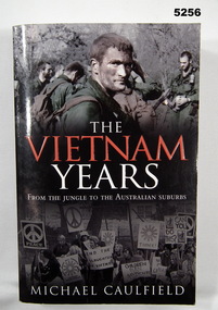 Bendigo Military Museum
Book - BOOK, VIETNAM WAR FROM BOTH SIDES, Michael CAULFIELD, "The Vietnam Years", 2007
"THE VIETNAM YEARS/FROM THE JUNGLE TO THE AUSTRALIAN SUBURBS". The Vietnam Years is the story of both sides of that war."Soft cover book. Soft cover - cardboard, red and white print on front, spine and back. Illustrated on front, top colour photograph of soldiers. Bottom black and white photograph of a civilian crowd. 493 pages, paper, cut, plain, white. Illustrated, black and white photographs and maps.books, history, vietnam war -
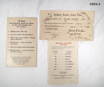 Bendigo Military Museum
Administrative record - LEAVE PASS & INFORMATION CARDS, c.1942
American Forces issue..1) Cream coloured Information card, black print on front. Map & information on reverse side in black & red print. .2) Cream coloured Sydney Leave Area Pass, black print. .3) Cream coloured Information sheet, paper, black & red print on both sides..2) Typed: “Sydney Leave Area Pass Thompson, Robert J Jnr, CPL Tech 33099209 Army from Dec 10 1943 to Dec 25 1943, APO 928 BRISBANE 2nd JN”administration, leave, pass -
 Bendigo Military Museum
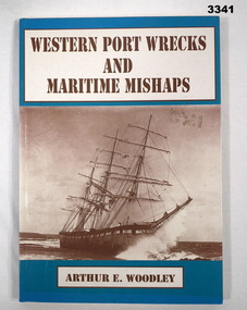
Book - BOOK, MARITIME, Arthur E Woodley, Western Port Wrecks & Maritime Mishaps, 1992
Soft cardboard cover. Brown print on front & spine, black print on back. Background colour aquamarine with front sepia photo of sailing ship. Back has 2 photos of the Cowes ferry. 103 pages, cut plain, off white. Illustrated with black & white photos & maps. Page XV has yellow highlighter pen applied to 2 sentences. Opposite p1, handwritten in blue ink on lined notepaper taped to page: “MIRANDA 1852, LADY MILDRED 1909, SEAGULL, CARPENTARIA, AT. * HARDWOOD. AIR. PORT, AMSTERDAM. FIVE (BEACHED), BUILT 1948. WORKED, YARRA RIVER, DIESEL MOTORS TOO BE RESTORED, * TOORADIN”book, maritime, wrecks, western port -
 Bendigo Military Museum
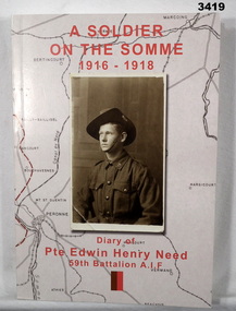
Book - BOOK WW1, Joan Scott, A Soldier of the Somme 1916 - 1918, 2014
Book, soft cover, cardboard, red print on front, spine & back. Sepia background map with half portrait sepia photo of soldier in uniform on front. 186 pages, cut plain, off white. Illustrated black & white photos, documents. End papers illustrated with diary notes.Title page: "Diary of Pte Edwin Henry Need, 59 Battalion AIF" Handwritten in black ink on title page: "Donated by Joan Scott" "Bendigo RSL stamp in black ink"book, somme, somme ww1 -
 Bendigo Military Museum
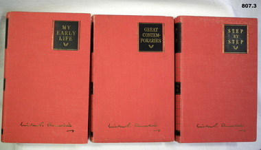
Book - SET OF BOOKS, Odhams Press Limited, 1) My Early Life; .2) Great Contempories; .3) Step by Step, 1) -.3) Reprinted 1948
3. Volume set. Autobiography by Winston Churchill; red cloth covers. Titles in gold on black panels. .1) 373 pages, plain, illustrated, black and white photographs. .2) 309 pages, plain, illustrated, black and white photographs. .3) 350 pages, plain, illustrated, map..1) - .3) Handwritten blue ink on title page "J.M. Coglin Feb 16th, 1949". .2) Handwritten blue ink on title page "Ralph ????ling Strathmore Loddon Vale"books, biography, military history -
 Bendigo Military Museum
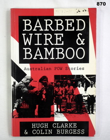
Book, Allen & Unwin Pty Ltd, Barbed Wire & Bamboo, 1992
Book, soft cover. Main background on front cover is red & white. Title is white ink on black background. Bottom half has 2 images showing Germans searching a British soldier & 4 Japanese guards lined up. 159 pages, illustrations, some maps & drawings.Donated by Bgo YMCA Stamped on 2nd fly leaf: Thailand Hellfire Pass ex POW Projectbooks, military, history, imprisonment -
 Flagstaff Hill Maritime Museum and Village
Document
1) Large map of Australia with information on explorers, navigators etc involved in its discovery. Title "The Discovery of Australia by Western Man" 2) Poster which explains in full information formulated on .1 Also gives in great detail natural history information relevant to the formation of the Australian continent.flagstaff hill, warrnambool, shipwrecked-coast, flagstaff-hill, flagstaff-hill-maritime-museum, maritime-museum, shipwreck-coast, flagstaff-hill-maritime-village -
 Bendigo Historical Society Inc.
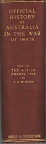
Book - OFFICIAL HISTORY OF AUSTRALIA IN THE WAR OF 1914-1918
Official History of Australia in the war of 1914-1918 Vol III The AIF in France 1916 - by C.E.W. Bean , published by Angus & Robertson 89 Castlereagh St Sydney 1942, maroon hard bound covered book with gold lettering, 475 illustrations and maps, signed Wesley Harry 1973.C.E.W. Beanbooks, military -
 Bendigo Historical Society Inc.
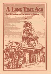
Document - A LONG TIME AGO: THE HISTORY OF THE MELBOURNE TO BENDIGO LINE
'A LONG TIME AGO: THE HISTORY OF THE MELBOURNE TO BENDIGO LINE' Bi-fold publication. A schematic 'strip' map of the line with particular places (approx 40) marked on the route with short descriptions of these sites. Concise description of the construction of the line; a summary of present attractions for the visitor to Bendigo and V/Line information.Walker Printing Bendigorailways, bendigo to melbourne, brochure, barkers creek , harcourt, elphinstone tunnel, malsmbury, malmsbury viaduct, kyneton, carlsruhe, hanging rock, woodend, mount macedon, riddells creek, clarkefield hotel, rupertswood, sunbury, diggers rest, sydenham, st albans, spencer street. v/line. -
 Bendigo Historical Society Inc.
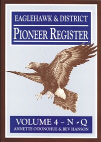
Book - EAGLEHAWK& DISTRICT PIONEER REGISTER VOLUME 4 N-Q, c2003
Eaglehawk & District Pioneer Register Volume 4 N-Q. Publisher Annette O'Donohue, Bendigo. ISBN: 0 9585948 6 4. 254 pages. Book Mark also included listing abbreviations and their meaning. Photographs, illustrations & maps. Signed by Annette O'Donohue & Bev Hanson 15.6.2003.Annette O'Donohue & Bev Hansonhistory, australian, pioneers, eaglehawk & district, bendigo history, eaglehawk pioneers, genealogy -
 Bendigo Historical Society Inc.
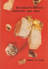
Book - BENDIGO'S MINING HISTORY 1851 - 1954, 1991
Bendigo's Mining History 1851 - 1954. Introduction and overview of gold and mining by the pioneers in the Bendigo area. Contains photographs, Illustrations and Maps. Page 1 has a letter of thanks from James Lerk to the Bendigo Historical Society for use of material in their collection. Autographed by author on 22 July 1991James A. Lerkhistory, mining -
 Bendigo Historical Society Inc.
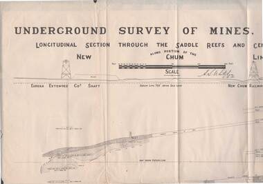
Map - STRUGNELL COLLECTION: NEW CHUM LINE OF REEF, 5/4/01
Map, Along portion of the New Chum Line, Underground Survey of Mines, Bendigo, Longitudinal Section through the Saddle Reefs and Centre Country. Eureka Extended Co's shaft, New Chum Railway Co's shaft. Surveyed under the supervision of H.Herman, B.C.E., F.G.S., Acting Government Geologist.H.S.Whitelowmap, bendigo, new chum line -
 Bendigo Historical Society Inc.
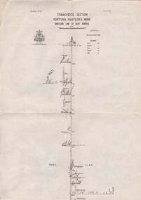
Map - STRUGNELL COLLECTION: HUSTLER'S LINE OF REEFS, BENDIGO, September 1913
Map, Hustler's Line of Reefs, Fortuna Hustler's Mine, Bendigo, Transverse Section. Plate Mo.111(3).Bulletin No 33 Signed H.A.Whitelaw. Drawing shows the vertical shaft descending to over 2228 feet and appears to show samples of connecting horizontal shafts with their respective mineral contentsUnderground Survey Office, Bendigo.map, bendigo, fortuna hustler's mine -
Port Melbourne Historical & Preservation Society
Flyer, Victorian Railways, Sandridge Rail Trail, 2005
Fold out flyer with black and white picture of train and three men on front cover. Back cover coloured image from Latrobe picture collection of park-like setting with steam train in background. Fold out section has history of railway, map, walk and ride descriptionstransport - railways, recreation, piers and wharves - station pier, piers and wharves - railway pier, hobson's bay railway company, melbourne and hobson's bay united railway company, montague street station, golden fleece hotel, st barnabas anglican church, north port station, lord raglan hotel -
 Bendigo Historical Society Inc.
Book - NORM GILLIES COLLECTION: COMPANY PROMOTIONAL POCKET DIARY
Gillies Company promotional gift pocket diary 1985 - blank unused Green plastic cover, with blue text including coloured maps Diary / almanac For 1985, covering 28/12/1984 to 02/01/1986 One of two pocket diaries (1984 diary refer 11850.17)